|
New Ireland (island)
New Ireland ( Tok Pisin: ''Niu Ailan'') or Latangai, is a large island in Papua New Guinea, approximately in area with 120,000 people. It is named after the island of Ireland. It is the largest island of New Ireland Province, lying northeast of the island of New Britain. Both islands are part of the Bismarck Archipelago, named after Otto von Bismarck, and they are separated by Saint George's Channel. The administrative centre of the island and of New Ireland province is the town of Kavieng located at the northern end of the island. While the island was part of German New Guinea, it was named Neumecklenburg ("New Mecklenburg"). Geography The island is part of the Bismarck Archipelago and is often described as having the shape of a musket. New Ireland is surrounded by the Bismarck Sea in the southwest and by the Pacific Ocean in the northeast. For much of its in length, the island's width varies between less than to , yet the central mountainous spine is very st ... [...More Info...] [...Related Items...] OR: [Wikipedia] [Google] [Baidu] |
Bismarck Archipelago
The Bismarck Archipelago (, ) is a group of islands off the northeastern coast of New Guinea in the western Pacific Ocean and is part of the Islands Region of Papua New Guinea. Its area is about 50,000 square km. History The first inhabitants of the archipelago arrived around 30–40,000 years ago. They may have traveled from New Guinea, by boat across the Bismarck Sea or via a temporary land bridge, created by an uplift in the Earth's Crust (geology), crust. Later arrivals included the Lapita people. The first European to visit these islands was Dutch explorer Willem Schouten in 1616. The islands remained unsettled by western Europeans until they were annexed as part of the German protectorate of German New Guinea in 1884. The area was named in honour of the Chancellor of Germany (German Reich), Chancellor Otto von Bismarck. On 1888 Ritter Island eruption and tsunami, 13 March 1888, a volcano erupted on Ritter Island causing a megatsunami. Almost the entire volcano fell into t ... [...More Info...] [...Related Items...] OR: [Wikipedia] [Google] [Baidu] |
Bismarck Sea
The Bismarck Sea (, ) lies in the southwestern Pacific Ocean within the nation of Papua New Guinea. It is located northeast of the island of New Guinea and south of the Bismarck Archipelago. It has coastlines in districts of the Islands Region, Momase Region, and Papua Region. Geography Like the Bismarck Archipelago, it is named in honour of the first German Chancellor Otto von Bismarck. The Bismarck Archipelago extends round to the east and north of the sea, enclosing the Bismarck Sea and separating it from the Southern Pacific Ocean. To the south it is linked to the Solomon Sea by the Vitiaz Strait. Official boundaries The International Hydrographic Organization defines the Bismarck Sea as "that area of the South Pacific Ocean off the northeast coast of New Guinea", with the following limits: ''On the North and East.'' By the Northern and Northeastern coasts of the islands of New Ireland, New Hanover, the Admiralty Islands, Hermit Island, and the Ninigo Group, through ... [...More Info...] [...Related Items...] OR: [Wikipedia] [Google] [Baidu] |
Willem Schouten
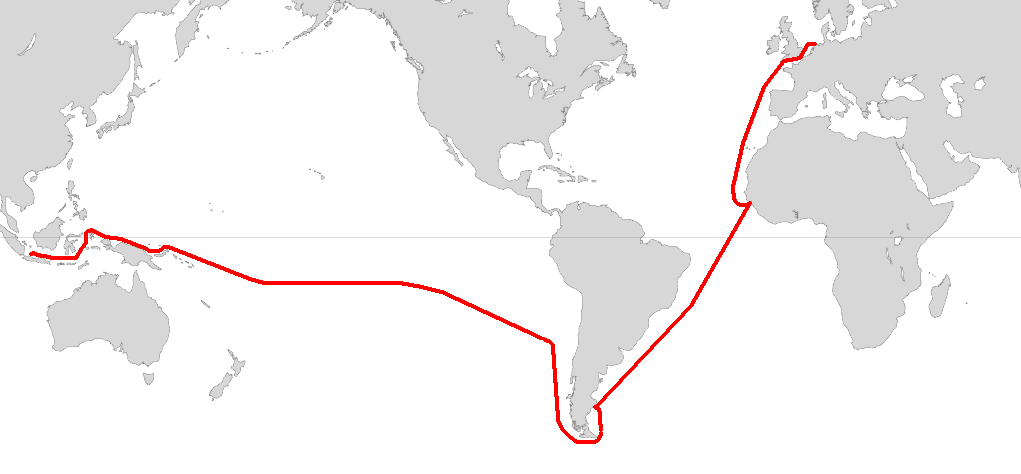
Willem Cornelisz Schouten ( – 1625) was a Dutch navigator for the Dutch East India Company. He was the first to sail the Cape Horn route to the Pacific Ocean. Biography Willem Cornelisz Schouten was born in c. 1567 in Hoorn, Holland, Seventeen Provinces. In 1615 Willem Cornelisz Schouten and his younger brother Jan Schouten sailed from Texel in the Netherlands, in an expedition led by Jacob Le Maire and sponsored by Isaac Le Maire and his ''Australische Compagnie'' in equal shares with Schouten. The expedition consisted of two ships: ''Eendracht'' and ''Hoorn''.Quanchi, ''Historical Dictionary of the Discovery and Exploration of the Pacific Islands'', pp. 222–33 A main purpose of the voyage was to search for '' Terra Australis''. A further objective was to explore a western route to the Pacific Ocean to evade the trade restrictions of the Dutch East India Company (VOC) in the Spice Islands. In 1616 Schouten rounded Cape Horn, which he named after the recently destro ... [...More Info...] [...Related Items...] OR: [Wikipedia] [Google] [Baidu] |
Jacob Le Maire
Jacob Le Maire (c. 1585 – 22 December 1616) was a Dutch mariner who circumnavigated the earth in 1615 and 1616. The strait between Tierra del Fuego and Isla de los Estados was named the Le Maire Strait in his honour, though not without controversy. It was Le Maire himself who proposed to the council aboard ''Eendracht'' that the new passage should be called by his name and the council unanimously agreed with Le Maire. The author or authors of ''The Relation'' took ''Eendracht'' captain Willem Schouten's side by proclaiming: :“ ... our men had each of them three cups of wine in signe of ioy for our good hap ... nd the naming ofthe ''Straights of Le Maire'', although by good right it should rather have been called ''Willem Schouten Straight'', after our Masters Name, by whose wise conduction and skill in sayling, the same was found.”. ''Eendracht'' then rounded Cape Horn, proving that Tierra del Fuego was not a continent. Biography Jacob Le Maire was born in either Antwerp ... [...More Info...] [...Related Items...] OR: [Wikipedia] [Google] [Baidu] |
Netherlands
) , anthem = ( en, "William of Nassau") , image_map = , map_caption = , subdivision_type = Sovereign state , subdivision_name = Kingdom of the Netherlands , established_title = Before independence , established_date = Spanish Netherlands , established_title2 = Act of Abjuration , established_date2 = 26 July 1581 , established_title3 = Peace of Münster , established_date3 = 30 January 1648 , established_title4 = Kingdom established , established_date4 = 16 March 1815 , established_title5 = Liberation Day (Netherlands), Liberation Day , established_date5 = 5 May 1945 , established_title6 = Charter for the Kingdom of the Netherlands, Kingdom Charter , established_date6 = 15 December 1954 , established_title7 = Dissolution of the Netherlands Antilles, Caribbean reorganisation , established_date7 = 10 October 2010 , official_languages = Dutch language, Dutch , languages_type = Regional languages , languages_sub = yes , languages = , languages2_type = Reco ... [...More Info...] [...Related Items...] OR: [Wikipedia] [Google] [Baidu] |
Malagan
Malagan (also spelled malangan or malanggan) ceremonies are large, intricate traditional cultural events that take place in parts of New Ireland province in Papua New Guinea. The word malagan refers to wooden carvings prepared for ceremonies and to an entire system of traditional culture. Malagan ceremonies ''Malagan'' ceremonies are the most large-scale and famous of the many events that take place within the ''malagan'' culture. They take place irregularly, and are typically large and complex events, taking several days, and requiring months or years of preparation. While a ''malagan'' ceremony is always held in the name of one or more people who have died in recent years, it is not at all merely a mortuary rite. Many other interactions take place within the overall event, including announcements, repayment of debts, recognition of obligations, resolution of disputes, and many other customary activities. Malagan carvings and carvers ''Malagan'' carvings, now world-fam ... [...More Info...] [...Related Items...] OR: [Wikipedia] [Google] [Baidu] |
Lapita
The Lapita culture is the name given to a Neolithic Austronesian peoples, Austronesian people and their material culture, who settled Island Melanesia via a seaborne migration at around 1600 to 500 BCE. They are believed to have originated from the northern Philippines, either directly, via the Mariana Islands, or both. They were notable for their distinctive geometric designs on dentate-stamped pottery, which closely resemble the pottery recovered from the Nagsabaran archaeological site in northern Luzon. The Lapita intermarried with the Papuans, Papuan populations to various degrees, and are the direct ancestors of the Austronesian peoples of Polynesia, eastern Micronesia, and Island Melanesia. Etymology The term 'Lapita' was coined by archaeologists after mishearing a word in the local Haveke language, ''xapeta'a'', which means 'to dig a hole' or 'the place where one digs', during the 1952 excavation in New Caledonia. The Lapita archaeological culture is named after the type ... [...More Info...] [...Related Items...] OR: [Wikipedia] [Google] [Baidu] |
Rainforest
Rainforests are characterized by a closed and continuous tree canopy, moisture-dependent vegetation, the presence of epiphytes and lianas and the absence of wildfire. Rainforest can be classified as tropical rainforest or temperate rainforest, but other types have been described. Estimates vary from 40% to 75% of all biotic species being indigenous to the rainforests. There may be many millions of species of plants, insects and microorganisms still undiscovered in tropical rainforests. Tropical rainforests have been called the "jewels of the Earth" and the " world's largest pharmacy", because over one quarter of natural medicines have been discovered there. Rainforests as well as endemic rainforest species are rapidly disappearing due to deforestation, the resulting habitat loss and pollution of the atmosphere. Definition Rainforest are characterized by a closed and continuous tree canopy, high humidity, the presence of moisture-dependent vegetation, a moist layer of ... [...More Info...] [...Related Items...] OR: [Wikipedia] [Google] [Baidu] |
Equator
The equator is a circle of latitude, about in circumference, that divides Earth into the Northern and Southern hemispheres. It is an imaginary line located at 0 degrees latitude, halfway between the North and South poles. The term can also be used for any other celestial body that is roughly spherical. In spatial (3D) geometry, as applied in astronomy, the equator of a rotating spheroid (such as a planet) is the parallel (circle of latitude) at which latitude is defined to be 0°. It is an imaginary line on the spheroid, equidistant from its poles, dividing it into northern and southern hemispheres. In other words, it is the intersection of the spheroid with the plane perpendicular to its axis of rotation and midway between its geographical poles. On and near the equator (on Earth), noontime sunlight appears almost directly overhead (no more than about 23° from the zenith) every day, year-round. Consequently, the equator has a rather stable daytime temperature ... [...More Info...] [...Related Items...] OR: [Wikipedia] [Google] [Baidu] |
Verron Range
The Verron Range is a mountain range in the southern part of New Ireland, Papua New Guinea, composed of limestone and volcanic rock. The highest point of the mountains is at 2,150 m. Together with the Hans Meyer Range and the Lelet Plateau, it is one of the main mountainous features of New Ireland. Geography The Verron Range is located in the broader southern part of New Ireland Island and runs roughly in a north–south-direction, parallel to the Hans Meyer Range. The Weitin valley divides the two ranges, Verron on the west and Hans Meyer on the east. This range was named "Verron" (Véron) after Pierre-Antoine Véron (1736-1770), the astronomer on Louis Antoine de Bougainville's ship who was able to determine the longitude by means of a solar eclipse around this location on 13 July 1768. This fact was important for it allowed Véron to establish the width of the Pacific Ocean with precision for the first time in history. While the island was part of German New Guinea, this rang ... [...More Info...] [...Related Items...] OR: [Wikipedia] [Google] [Baidu] |


