|
Nesselberg
The Nesselberg is a ridge up to high in the Calenberg Highland which, together with the Kleiner Deister and the Osterwald, forms a group of three contiguous hill regions in the northwestern part of the Leine Uplands. It lies between Altenhagen I and Coppenbrügge in Lower Saxony, Germany. Geography The Nesselberg is located more or less north of Coppenbrügge, immediately south of the Kleiner Deister and north west of the Osterwald. It lies north of the Gelbbach valley, through which state road no. 422 runs from Eldagsen to Coppenbrügge. Immediately east of this valley is the Osterwald. The border between Hanover region and the district of Hameln-Pyrmont runs along the crest of the Nesselberg. On the saddle between the Nesselberg and Kleine Deister, and therefore between the Wolfsköpfen to the northeast and the Grasberg to the southwest, stands the old ''Wolfsbuche'' (today a car park for walkers); the Schwarze Bach ("Black Brook"), a tributary of the Gehlenbach rises ... [...More Info...] [...Related Items...] OR: [Wikipedia] [Google] [Baidu] |
Kleiner Deister
The Kleiner Deister is a ridge of hills (up to ) in the Calenberg Uplands which, together with the Nesselberg and the Osterwald, forms a group of three adjacent hill ranges in the northern part of the Leine Uplands. It lies between Springe and Eldagsen (Springe), Eldagsen in Hanover region in Lower Saxony, Germany. Geography The Kleiner Deister is located immediately south of Springe and just north of the Nesselberg. It is drained by the river Haller (river), Haller. The Bundesstraße 217, B 217 federal highway from Hanover to Hamelin runs through the flat Mountain pass, pass of the Deister Gate. In the south east the Kleiner Deister is separated from the northern foothills of the Osterwald by a valley through which run both the Gehlenbach stream and the Landesstraße, L 422 from Eldagsen (Springe), Eldagsen to Coppenbrügge. At once time the old ''Wolfsbuche'' stood on the saddle between the Kleiner Deister and the Nesselberg and therefore between the Wolfsköpfe in the nort ... [...More Info...] [...Related Items...] OR: [Wikipedia] [Google] [Baidu] |
Leine Uplands
The Leine Uplands (german: Leinebergland, ) is a region in Germany's Central Uplands which forms a part of the Lower Saxon Hills and lies along the River Leine between Göttingen and Hanover. It borders on the Weser Uplands in the west, the Innerste Uplands in the northeast, the Harz in the east and Untereichsfeld in the southeast. Geography The Leine Uplands, which merge into the Weser Uplands to the east and the Harz to the west, are not a clearly defined landscape in terms of being a natural region but are nevertheless relatively easily delineated. Their extent from south to north is determined by the river that lends them their name and their extent from east to west by high ridges. From north to south the uplands can be broadly divided into a southern half around the wide trough of the River Leine's middle course and a northern half by the lower reaches of the same river. Landscapes either side of the Leine trough The River Leine flows from Friedland via Göttingen an ... [...More Info...] [...Related Items...] OR: [Wikipedia] [Google] [Baidu] |
Common Database On Designated Areas
The Common Database on Designated Areas or CDDA is a data bank for officially designated protected areas such as nature reserves, protected landscapes, national parks etc. in Europe. The data bank, which went live in 1999, is a community project of the European Environment Agency (EEA) of the Council of Europe and the United Nations Environment Programme World Conservation Monitoring Centre (UNEP-WCMC). The data bank is divided into a national area and an international area. The national area is for member states of the EU or EEA about the European Environment Information and Observation Network or ''EIONET''. Data cleansing for the national area of non-EEA members and the international area is carried out by UNEP-WCMC systems. The data bank follows the system of the International Union for Conservation of Nature and Natural Resources (IUCN) and the standards of the United Nations in order to ensure compatibility with similar data banks worldwide, especially the World Database on ... [...More Info...] [...Related Items...] OR: [Wikipedia] [Google] [Baidu] |
Berlin
Berlin ( , ) is the capital and largest city of Germany by both area and population. Its 3.7 million inhabitants make it the European Union's most populous city, according to population within city limits. One of Germany's sixteen constituent states, Berlin is surrounded by the State of Brandenburg and contiguous with Potsdam, Brandenburg's capital. Berlin's urban area, which has a population of around 4.5 million, is the second most populous urban area in Germany after the Ruhr. The Berlin-Brandenburg capital region has around 6.2 million inhabitants and is Germany's third-largest metropolitan region after the Rhine-Ruhr and Rhine-Main regions. Berlin straddles the banks of the Spree, which flows into the Havel (a tributary of the Elbe) in the western borough of Spandau. Among the city's main topographical features are the many lakes in the western and southeastern boroughs formed by the Spree, Havel and Dahme, the largest of which is Lake Müggelsee. Due to its l ... [...More Info...] [...Related Items...] OR: [Wikipedia] [Google] [Baidu] |
Reichstag Building
The Reichstag (, ; officially: – ; en, Parliament) is a historic government building in Berlin which houses the Bundestag, the lower house of Germany's parliament. It was constructed to house the Imperial Diet (german: Reichstag) of the German Empire. It was opened in 1894 and housed the Diet until 1933, when it was set on fire. In World War II, during the Battle of Berlin, the building was severely damaged by the Soviet Red Army. After the War, the building fell into disuse; the parliament of the German Democratic Republic (the ) met in the Palast der Republik in East Berlin, while the parliament of the Federal Republic of Germany (the Bundestag) met in the in Bonn. The ruined building was made safe against the elements and partially refurbished in the 1960s, but no attempt at full restoration was made until after German reunification on 3 October 1990, when it underwent a reconstruction led by architect Norman Foster. After its completion in 1999, it once again be ... [...More Info...] [...Related Items...] OR: [Wikipedia] [Google] [Baidu] |
Hanover
Hanover (; german: Hannover ; nds, Hannober) is the capital and largest city of the German state of Lower Saxony. Its 535,932 (2021) inhabitants make it the 13th-largest city in Germany as well as the fourth-largest city in Northern Germany after Berlin, Hamburg and Bremen. Hanover's urban area comprises the towns of Garbsen, Langenhagen and Laatzen and has a population of about 791,000 (2018). The Hanover Region has approximately 1.16 million inhabitants (2019). The city lies at the confluence of the River Leine and its tributary the Ihme, in the south of the North German Plain, and is the largest city in the Hannover–Braunschweig–Göttingen–Wolfsburg Metropolitan Region. It is the fifth-largest city in the Low German dialect area after Hamburg, Dortmund, Essen and Bremen. Before it became the capital of Lower Saxony in 1946, Hannover was the capital of the Principality of Calenberg (1636–1692), the Electorate of Hanover (1692–1814), the Kingdom of Hannover ... [...More Info...] [...Related Items...] OR: [Wikipedia] [Google] [Baidu] |
New City Hall (Hanover)
The New Town Hall (german: Neues Rathaus) is a city hall in Hanover, Germany. It opened on 20 June 1913 after construction lasting 12 years. A magnificent, castle-like building of the era of Wilhelm II in eclectic style at the southern edge of the inner city just outside the historic city centre of Hanover, the building is embedded within the . History Costing 10 million Marks, the New Town Hall was erected on 6026 beech piles by architects Hermann Eggert and Gustav Halmhuber. "Ten million Marks, Your Majesty – and all paid for in cash", the City Director, , is claimed to have announced when the New Town Hall was opened in the presence of Emperor Wilhelm II. In honour of Tramm the square in front of the building is named ''Trammplatz''. Upon opening, the New Town Hall replaced the as the main seat of administration, which had moved from the Old Town Hall into the Wangenheimpalais in 1863. , the New Town Hall is still "the residence of the Mayor and CEO, the head ... [...More Info...] [...Related Items...] OR: [Wikipedia] [Google] [Baidu] |
Opera House
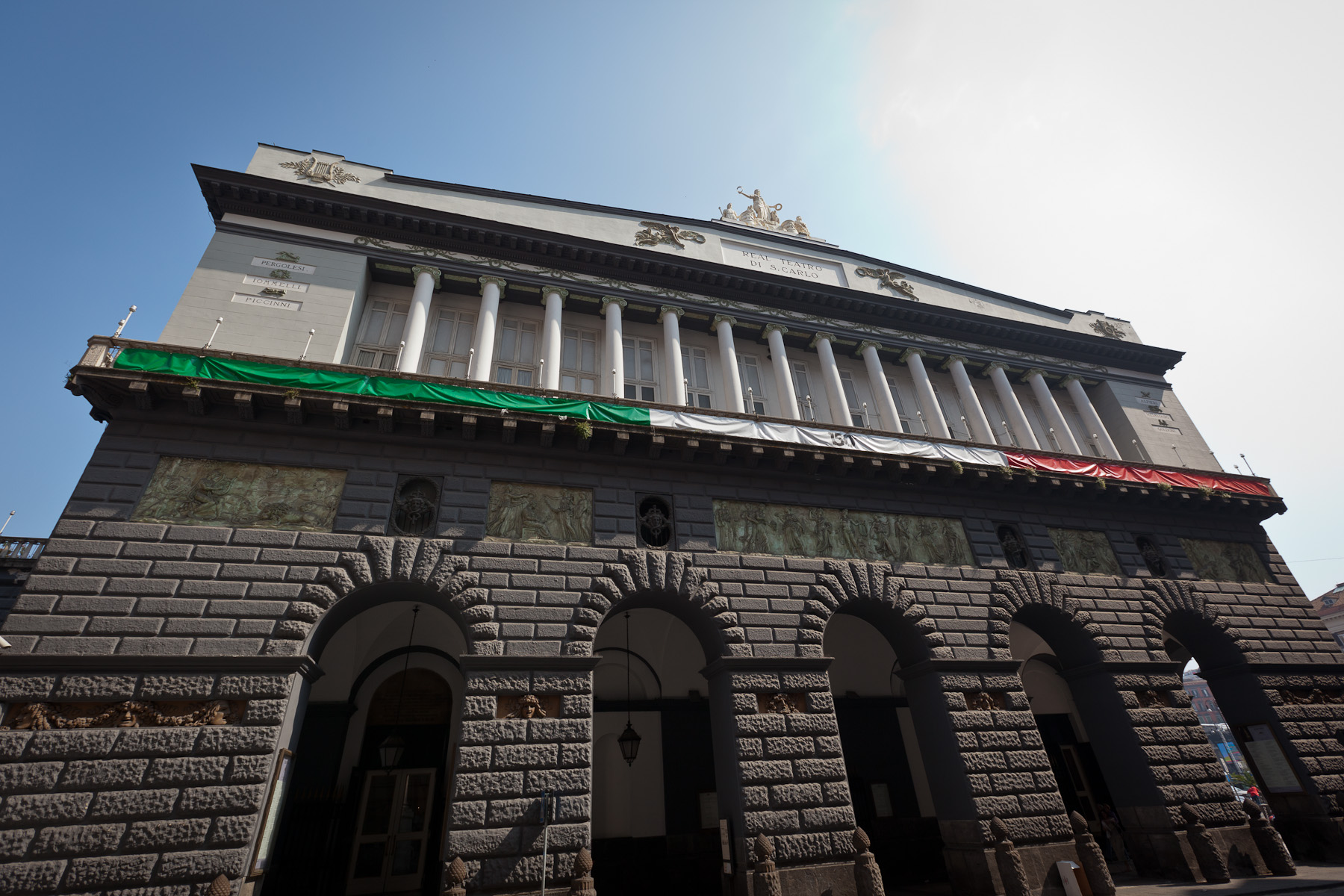
An opera house is a theatre building used for performances of opera. It usually includes a stage, an orchestra pit, audience seating, and backstage facilities for costumes and building sets. While some venues are constructed specifically for operas, other opera houses are part of larger performing arts centers. Indeed, the term ''opera house'' is often used as a term of prestige for any large performing-arts center. History Italy is a country where opera has been popular through the centuries among ordinary people as well as wealthy patrons and it continues to have many working opera houses such as Teatro Massimo in Palermo (the biggest in Italy), Teatro di San Carlo in Naples (the world's oldest working opera house) and Teatro La Scala in Milan. In contrast, there was no opera house in London when Henry Purcell was composing and the first opera house in Germany, the Oper am Gänsemarkt, was built in Hamburg in 1678, followed by the Oper am Brühl in Leipzig in 1693, and t ... [...More Info...] [...Related Items...] OR: [Wikipedia] [Google] [Baidu] |
Circular Rampart
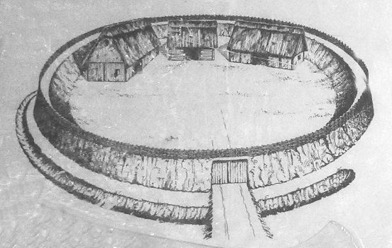
A circular rampart (German: ''Ringwall'') is an embankment built in the shape of a circle that was used as part of the defences for a military fortification, hill fort or refuge, or was built for religious purposes or as a place of gathering. The period during which these structures were built ranged from the Neolithic to the Middle Ages. Construction The key feature of a circular rampart is that the embankment formed the primary element of the defensive fortification. It can be constructed in various ways: as a simple earth embankment, as a wood and earth structure, or as a wall. Circular ramparts usually have a moat or ditch in front of them; the embankment can be enhanced with a wooden palisade. Often several concentric rings were built, which produced a more effective defensive position against attackers. The interior of such sites often shows evidence of buildings such as halls, barns, and other secondary structures. Locations Circular ramparts are found in north and we ... [...More Info...] [...Related Items...] OR: [Wikipedia] [Google] [Baidu] |
Lower Cretaceous
Lower may refer to: *Lower (surname) *Lower Township, New Jersey *Lower Receiver (firearms) *Lower Wick Lower Wick is a small hamlet located in the county of Gloucestershire, England. It is situated about five miles south west of Dursley, eighteen miles southwest of Gloucester and fifteen miles northeast of Bristol. Lower Wick is within the civil ... Gloucestershire, England See also * Nizhny {{Disambiguation ... [...More Info...] [...Related Items...] OR: [Wikipedia] [Google] [Baidu] |


.jpg)


