|
Natori District, Miyagi
was a districts of Japan, district located in Rikuzen Province (formerly in the central part of Mutsu Province) in Miyagi Prefecture. History From Ancient Establishment to Pre-modern Alignment (7C - 19C) Many kofuns had been built in the area of the future Natori district since the 5th century. Especially Raijinyama Kofun was the largest in the Tōhoku region of Honshu. The district was founded in the 7th century. Kōriyama Site had been the capital of Mutsu province since the end of the 7th century until 724. Natori Dan (Natori Battalion) had been long maintained as one of two, six or seven battalions of the province. Heijō-kyō excavation team discovered a wood tag attaching kombu (sea grass) tribute in 729 from "Natori district of Mutsu province" to the palace. And although date and year are unknown, a word ''Notori'' was written on a cup excavated at the Kōriyama Site. The first appearance in reliable literature is in ''Shoku Nihongi'' when Kimikobe Okina, a person of N ... [...More Info...] [...Related Items...] OR: [Wikipedia] [Google] [Baidu] |
Districts Of Japan
In Japan, a is composed of one or more rural municipalities (Towns of Japan, towns or Villages of Japan, villages) within a Prefectures of Japan, prefecture. Districts have no governing function, and are only used for geographic or statistical purposes such as mailing addresses. Cities of Japan, Cities are not part of districts. Historically, districts have at times functioned as an administrative unit in Japan, administrative unit. From 1878 to 1921The governing law, the district code (''gunsei'', 郡制Entry for the 1890 originalanentry for the revised 1899 ''gunsei''in the National Diet Library ''Nihon hōrei sakuin''/"Index of Japanese laws and ordinances"), was abolished in 1921, but the district assemblies (''gunkai'', 郡会) existed until 1923, the district chiefs (''gunchō'', 郡長) and district offices (''gun-yakusho'', 郡役所) until 1926. district governments were roughly equivalent to a County (United States), county of the United States, ranking below Prefectu ... [...More Info...] [...Related Items...] OR: [Wikipedia] [Google] [Baidu] |
Akiu, Miyagi
was a town located in Natori District, Miyagi Prefecture from 1967 to 1988. It is now the western part of Taihaku-ku, Sendai. Geography Most of the town limits are forest, and it is the drainage basin of Natori River. The town has many tourism resources from Akiu Waterfalls to Rairaikyo, to Akiu Hot Springs and Futakuchi Hot Springs. * Mountain Peaks - Mount Kamuro (1,356m), Mount Ōkura (433m), Mount Taihaku (321m) * Rivers - Natori River, Zaru River Surrounding municipalities * Miyagi Prefecture ** Sendai ** Kawasaki * Yamagata Prefecture ** Yamagata ** Higashine History * 1947 - The villages of Nikkawa (新川村), (馬場村), (長袋村), (境野村) and (湯元村) merged to become the village of Akiu. * 1955 - Former village of Nikkawa area was moved to the village of Miyagi. * 1967 - Becomes the town of Akiu. * 1988 - Absorbed by the city of Sendai. Transportation Railroads * Akiu Electronic Railway Akiu Line (cancelled in 1961) : Rairaikyō ... [...More Info...] [...Related Items...] OR: [Wikipedia] [Google] [Baidu] |
Iwanuma, Miyagi
270px, Iwanuma City Hall is a city located in Miyagi Prefecture, Japan. , the city had an estimated population of 43,946 in 18,062 households, and a population density of 730 persons per km². The total area of the city is . Iwanuma is at the convergence of two ancient roads, the Tōkaidō and the Rikuzen-Hama Kaidō. Geography Iwanuma is in the east-center Miyagi Prefecture, bordered by the Pacific Ocean to the east. It is also located at the mouth of the Abukuma River. Neighboring municipalities Miyagi Prefecture * Natori * Shibata * Murata * Watari Climate Iwanuma has a humid climate (Köppen climate classification ''Cfa'') characterized by mild summers and cold winters. The average annual temperature in Iwanuma is 12.6 °C. The average annual rainfall is 1252 mm with September as the wettest month. The temperatures are highest on average in August, at around 24.9 °C, and lowest in January, at around 1.6 °C. Demographics Per Japanese census data, t ... [...More Info...] [...Related Items...] OR: [Wikipedia] [Google] [Baidu] |
Natori, Miyagi
is a city located in Miyagi Prefecture, Japan. , the city had an estimated population of 79,459 in 31,748 households, and a population density of 810 persons per km². The total area of the city is . Geography Natori is in east-central Miyagi Prefecture, bordered by the Pacific Ocean to the east. Natori is located in the fertile plains of the Natori River and the Masuda River deltas; however, the Natori River is actually not inside Natori city limits. Traditionally, the area known as Natori District extended from the Natori River in the north and into the west. However, these regions have been absorbed into the greater Sendai area and are no longer part of Natori. Neighboring municipalities Miyagi Prefecture *Sendai * Murata *Iwanuma Climate Natori has a humid climate (Köppen climate classification ''Cfa'') characterized by mild summers and cold winters. The average annual temperature in Natori is . The average annual rainfall is with September as the wettest month. The t ... [...More Info...] [...Related Items...] OR: [Wikipedia] [Google] [Baidu] |
Sendai, Miyagi
is the capital city of Miyagi Prefecture, the largest city in the Tōhoku region. , the city had a population of 1,091,407 in 525,828 households, and is one of Japan's 20 designated cities. The city was founded in 1600 by the ''daimyō'' Date Masamune. It is nicknamed the ; there are Japanese zelkova trees lining many of the main thoroughfares such as and . In the summer, the Sendai Tanabata Festival, the largest Tanabata festival in Japan, is held. In winter, the trees are decorated with thousands of lights for the , lasting through most of December. On 11 March 2011, coastal areas of the city suffered catastrophic damage from a magnitude 9.0 offshore earthquake,UK Foreign Office 9.0 assessment [...More Info...] [...Related Items...] OR: [Wikipedia] [Google] [Baidu] |
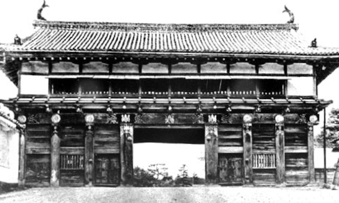
Sendai Castle
260px, Layout of Aoba Castle is a Japanese castle located in Sendai, Miyagi Prefecture, Japan. Throughout the Edo period, Aoba Castle was home to the Date clan, ''daimyō'' of Sendai Domain. The castle was also known as or as . In 2003, the castle ruins were designated a National Historic Site. Design Aoba Castle is located on a plateau overlooking the city of Sendai on the opposing bank of the Hirose River. The site is protected by cliffs to the south and east, and by a deep forest to the west. This forest was strictly guarded in the Edo period and is a rare survivor of the original virgin forests in Honshū. The area is now managed as a botanical garden by Tohoku University. The castle hill is partially surrounded by the Hirose River to the north and east, and a steep slope protects the south. The ''Honmaru'' (inner bailey) is about 115 meters high, and is a roughly square-shaped area 250 meters long surrounded by stone walls, in some places 15 meters high. It contained the ... [...More Info...] [...Related Items...] OR: [Wikipedia] [Google] [Baidu] |
Sendai
is the capital Cities of Japan, city of Miyagi Prefecture, the largest city in the Tōhoku region. , the city had a population of 1,091,407 in 525,828 households, and is one of Japan's 20 Cities designated by government ordinance of Japan, designated cities. The city was founded in 1600 by the ''daimyō'' Date Masamune. It is nicknamed the ; there are Japanese zelkova trees lining many of the main thoroughfares such as and . In the summer, the Sendai Tanabata Festival, the largest Tanabata festival in Japan, is held. In winter, the trees are decorated with thousands of lights for the , lasting through most of December. On 11 March 2011, coastal areas of the city suffered catastrophic damage from a 2011 Tōhoku earthquake and tsunami, magnitude 9.0 offshore earthquake,UK Foreign Office 9.0 assessment [...More Info...] [...Related Items...] OR: [Wikipedia] [Google] [Baidu] |
Sendai Domain
The , also known as the , was a domain of the Tokugawa Shogunate of Japan during the Edo period from 1600 to 1871. The Sendai Domain was based at Aoba Castle in Mutsu Province, in the modern city of Sendai, located in the Tōhoku region of the island of Honshu. The Sendai Domain was ruled for its existence by the '' tozama'' ''daimyō'' of the Date, and under the ''kokudaka'' system its income rating at 625,000 ''koku'' was the third-largest domain in Japan after the Satsuma Domain and Kaga Domain. The Sendai Domain was geographically the largest domain in northern Japan with its mostly-contiguous holdings covering most of southern Mutsu Province, including all of present-day Miyagi Prefecture, parts of southern Iwate Prefecture and northeastern Fukushima Prefecture. The Sendai Domain was the focal member of the Ōuetsu Reppan Dōmei against the Meiji Restoration during the Boshin War. The Sendai Domain was dissolved in the abolition of the han system in 1871 by the Meiji governme ... [...More Info...] [...Related Items...] OR: [Wikipedia] [Google] [Baidu] |


