|
Namkha Rural Municipality
Namkha ( ne, नाम्खा) is the largest rural municipality (by area) of Nepal located in Humla District of Karnali Province. The total area of the rural municipality is and total population is 3900 individuals (as of 2011 Nepal census) only. The rural municipality is divided into 6 wards. The rural municipality was established on 10 March 2017, when Government of Nepal restricted all old administrative structure ( Village development committee) and announced 744 local level units (although the number increased to 753 later) as per the new constitution of Nepal 2015. Hepka, Khagalgaun, Muchu and Limi Village development committees were incorporated to form this new rural municipality. The headquarters of the municipality is situated at Yalwang. Namkha RM is located in the most North-west part of Nepal in Humla District of Karnali Province. It is surrounded by Tibet (China) from North and West. Geographically Namkha is a difficult terrain which is also an isolated regi ... [...More Info...] [...Related Items...] OR: [Wikipedia] [Google] [Baidu] |
List Of Gaunpalikas Of Nepal
Gaunpalika ( ne, गाउँपालिका, lit=Rural municipal, translit=gāunpālikā}) is the newly formed lower administrative division in Nepal. This administrative division was established in 2017, and replaced the existing Village development committee (Nepal), village development committees. There are currently 460 rural municipalities. This is a list of the Gaunpalika or rural municipalities of Nepal published by the Ministry of Federal Affairs and General Administration (Nepal), Ministry of Federal Affairs and General Administration. Classification The Ministry of Federal Affairs and General Administration (Nepal), Ministry of Federal Affairs and General Administration has classified the local units into four grades based on infrastructure and social development. Province No. 1 There are a total of 88 Rural municipalities in Province No. 1 spread in 14 districts. *Sunkoshi (other), Sunkoshi is a name of three Gaunpalika, rural municipalities in Nep ... [...More Info...] [...Related Items...] OR: [Wikipedia] [Google] [Baidu] |
The Himalayan Times
''The Himalayan Times'' is an English-language broadsheet newspaper published and distributed daily in Nepal Nepal (; ne, नेपाल ), formerly the Federal Democratic Republic of Nepal ( ne, सङ्घीय लोकतान्त्रिक गणतन्त्र नेपाल ), is a landlocked country in South Asia. It is mai .... Rajan Pokhrel is the acting editor. In the annual newspaper classification report published by Press Council Nepal,it was placed in the A+ category, the highest possible rank. The newspaper was founded on 23 November 2001. It is based in Maharajgunj, Kathmandu. It is owned by International Media Network Nepal (Pvt) Ltd which in turn is owned by a Nepali investors. The paper's competitors tried to organise and lobby against the entry of foreign-owned newspaper in the country, but were not successful. At the time of its founding, it published in 12 pages, six of them coloured, and was priced as Rs 2. Within a year, it had b ... [...More Info...] [...Related Items...] OR: [Wikipedia] [Google] [Baidu] |
Simkot
Simkot ( ne, सिमकोट गाउँपालिका) is a rural municipality located in Humla District of Karnali Province of Nepal. The rural municipality is divided into total 8 wards and the headquarters of the rural municipality is situated at Simikot. Simikot airport is one and only airport of Humla, located on Simikot. Simkot serves as the gateway to Mansarobar/ Kailash pilgrimage. Demographics At the time of the 2011 Nepal census, 80.0% of the population in Simkot Rural Municipality spoke Nepali, 18.7% Tamang, 0.3% Magar, 0.3% Sign language, 0.2% Maithili and 0.1% Doteli as their first language; 0.4% spoke other languages. In terms of ethnicity/caste, 40.5% were Chhetri, 25.1% Thakuri, 19.1% Tamang, 9.9% Kami, 1.9% Damai/Dholi, 1.1% Hill Brahmin, 0.8% Byasi/Sauka, 0.5% Magar and 1.1% others. In terms of religion, 80.2% were Hindu, 19.4% Buddhist, 0.2% Christian, 0.1% Muslim Muslims ( ar, المسلمون, , ) are people who adhere to Islam, a ... [...More Info...] [...Related Items...] OR: [Wikipedia] [Google] [Baidu] |
Tibet Autonomous Region
The Tibet Autonomous Region or Xizang Autonomous Region, often shortened to Tibet or Xizang, is a Provinces of China, province-level Autonomous regions of China, autonomous region of the China, People's Republic of China in Southwest China. It was overlayed on the traditional Tibetan regions of Ü-Tsang and Kham. It was formally established in 1965 to replace the Tibet Area (administrative division), Tibet Area, the former Administrative divisions of China, administrative division of the People's Republic of China (PRC) established after the annexation of Tibet by the People's Republic of China, annexation of Tibet. The establishment was about five years after the 1959 Tibetan uprising and the dismissal of the Kashag, and about 13 years after the original annexation. The current borders of the Tibet Autonomous Region were generally established in the 18th century and include about half of historic Tibet, or the Tibet, ethno-cultural Tibet. The Tibet Autonomous Region spans ov ... [...More Info...] [...Related Items...] OR: [Wikipedia] [Google] [Baidu] |
Burang County
Purang County or Burang County (; ) is an administrative division of Ngari Prefecture in the Tibet Autonomous Region (''TAR'') of China. The county seat is Purang Town, known as ''Taklakot'' in Nepali. The county covers an area of , and has a population of 9,657 as of 2010. Geography Political geography Purang County has TAR's south-western border with Nepal's Sudurpashchim and Karnali province, Darchula, Bajhang and Humla District. Further west, India's Uttarakhand State, Pithoragarh district and Chamoli district borders. Buddhist, Hindu and Jain pilgrims going to Lake Manasarovar and Mount Kailash enter from Nepal via Simikot, and from India via Dharchula. The county is bounded by other counties in the Ngari Prefecture, including Zanda to the west, Gar to the northwest and Gê'gyai to the north. To the east is Zhongba County of Shigatse Prefecture. Physical geography The county covers an area of , and has a population of some 9,058 people as of 2010. The county seat, l ... [...More Info...] [...Related Items...] OR: [Wikipedia] [Google] [Baidu] |
Trekking
Backpacking is the outdoor recreation of carrying gear on one's back, while hiking for more than a day. It is often an extended journey, and may involve camping outdoors. In North America tenting is common, where simple shelters and mountain huts, widely found in Europe, are rare. In New Zealand, hiking is called tramping and tents are used alongside a nationwide network of huts. Hill walking is an equivalent in Britain (but this can also refer to a day walk), though backpackers make use of a variety of accommodation, in addition to camping. Backpackers use simple huts in South Africa. Trekking and bushwalking are other words used to describe such multi-day trips. Backpacking as a method of travel is a different activity, which mainly uses public transport during a journey which can last months. Definition Backpacking is an outdoor recreation where gear is carried in a backpack. This can include food, water, bedding, shelter, clothing, stove, and cooking kit. Given that back ... [...More Info...] [...Related Items...] OR: [Wikipedia] [Google] [Baidu] |
Himalayas
The Himalayas, or Himalaya (; ; ), is a mountain range in Asia, separating the plains of the Indian subcontinent from the Tibetan Plateau. The range has some of the planet's highest peaks, including the very highest, Mount Everest. Over 100 peaks exceeding in elevation lie in the Himalayas. By contrast, the highest peak outside Asia (Aconcagua, in the Andes) is tall. The Himalayas abut or cross five countries: Bhutan, India, Nepal, China, and Pakistan. The sovereignty of the range in the Kashmir region is disputed among India, Pakistan, and China. The Himalayan range is bordered on the northwest by the Karakoram and Hindu Kush ranges, on the north by the Tibetan Plateau, and on the south by the Indo-Gangetic Plain. Some of the world's major rivers, the Indus, the Ganges, and the Tsangpo–Brahmaputra, rise in the vicinity of the Himalayas, and their combined drainage basin is home to some 600 million people; 53 million people live in the Himalayas. The Himalayas have ... [...More Info...] [...Related Items...] OR: [Wikipedia] [Google] [Baidu] |
Simikot
Simikot is the administrative headquarters of Humla District of Karnali Zone in the mountain region of northwestern Nepal. Significance Lying at an altitude of just over 2,900m on a gentle slope high above the Humla Karnali River, Simikot lies on an ancient trade-cum-pilgrimage route to Mount Kailash. Mount Kailash is located in the Purang County of the Tibetan Autonomous Region, China, which borders Humla district of Nepal to the north. In the April 2015 Nepal earthquake, the popular Tatopani-Zhangmu route for the pilgrimage to Mount Kailash was badly damaged. In the aftermath of this earthquake the traffic for the annual pilgrimage to Mount Kailash shifted to Humla. Pilgrims would fly from Kathmandu to Nepalgunj, and then from Nepalgunj to Simikot. At Simikot, they would either spend a night in this village's few hotels, or would straightaway be taken in helicopter flights to Hilsa, from where they would cross into Tibet (China). Transport Access to Simikot from developed ... [...More Info...] [...Related Items...] OR: [Wikipedia] [Google] [Baidu] |
Tibet
Tibet (; ''Böd''; ) is a region in East Asia, covering much of the Tibetan Plateau and spanning about . It is the traditional homeland of the Tibetan people. Also resident on the plateau are some other ethnic groups such as Monpa people, Monpa, Tamang people, Tamang, Qiang people, Qiang, Sherpa people, Sherpa and Lhoba peoples and now also considerable numbers of Han Chinese and Hui people, Hui settlers. Since Annexation of Tibet by the People's Republic of China, 1951, the entire plateau has been under the administration of the People's Republic of China, a major portion in the Tibet Autonomous Region, and other portions in the Qinghai and Sichuan provinces. Tibet is the highest region on Earth, with an average elevation of . Located in the Himalayas, the highest elevation in Tibet is Mount Everest, Earth's highest mountain, rising 8,848.86 m (29,032 ft) above sea level. The Tibetan Empire emerged in the 7th century. At its height in the 9th century, the Tibet ... [...More Info...] [...Related Items...] OR: [Wikipedia] [Google] [Baidu] |
Limi
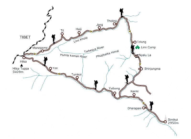
Limi Valley is a high-altitude valley that forms the northernmost part of the Humla District of north-western Nepal. To its north, the Limi valley borders the Purang County of Tibet, China. Administrative Limi is a ward council of the Namkha rural municipality of the Humla district, which itself is a part of the Karnali Province. Previously the whole valley was known as the Limi Village Development Committee (VDC). As of the 1991 Nepal census, Limi valley had a population of 988 persons living in 169 individual households. The population of the valley decreased to 904 individual according to 2011 Nepal census. Geography The Limi valley is drained by the Limi river, a tributary of the Humla Karnali river. This valley has only three settlements, the Dzang, Halji, and Til villages. Dzang lies at 3,920m, Halji at 3,700m, and Til at 4,100m above sea level. Halji village is located on the southern slopes of the Gurla Mandhata massif. Access To go to the Limi valley, one first ... [...More Info...] [...Related Items...] OR: [Wikipedia] [Google] [Baidu] |


