|
N11 Road (Ghana)
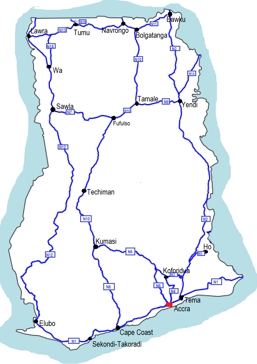
The N11 or National Highway 11 is a national highway in Ghana that begins at Bolgatanga in the Upper East Region ( N10) and runs east to Bawku, where it intersects with the N2. The N11 is 110.8 km long. Route Major towns and cities along the route of the N11 include Bolgatanga, Zuarungu, Zebilla and Bawku. See also *Ghana Road Network Roads in Ghana form a network of varied quality and capacity. Responsibility for the road network differs between trunk and non-trunk routes. Trunk roads, which are the most important roads, are administered by the Ghana Highway Authority, which ... References {{Reflist Roads in Ghana ... [...More Info...] [...Related Items...] OR: [Wikipedia] [Google] [Baidu] |
Ghana
Ghana (; tw, Gaana, ee, Gana), officially the Republic of Ghana, is a country in West Africa. It abuts the Gulf of Guinea and the Atlantic Ocean to the south, sharing borders with Ivory Coast in the west, Burkina Faso in the north, and Togo in the east.Jackson, John G. (2001) ''Introduction to African Civilizations'', Citadel Press, p. 201, . Ghana covers an area of , spanning diverse biomes that range from coastal savannas to tropical rainforests. With nearly 31 million inhabitants (according to 2021 census), Ghana is the List of African countries by population, second-most populous country in West Africa, after Nigeria. The capital and List of cities in Ghana, largest city is Accra; other major cities are Kumasi, Tamale, Ghana, Tamale, and Sekondi-Takoradi. The first permanent state in present-day Ghana was the Bono state of the 11th century. Numerous kingdoms and empires emerged over the centuries, of which the most powerful were the Kingdom of Dagbon in the north and ... [...More Info...] [...Related Items...] OR: [Wikipedia] [Google] [Baidu] |
Bolgatanga
Bolgatanga ( Frafra: ''''), colloquially known as ''Bolga'', is a town and the capital of the Bolgatanga Municipal District and Upper East Region of Ghana, adjacent to the border with Burkina Faso. Bolgatanga has over 2012 settlement and a population of about 66,685 people. Bolgatanga is 161 km (about 100 miles) to the north of Tamale. Bolgatanga lies in the Red Volta River Valley (which serves as a major migration route of elephants), with the White Volta River and the cliffs of the Gambaga Escarpment to the south of the town forming the southern boundary of the Upper East Region. History of Bolgatanga The name Bolgatanga (Bolbatanga) was derived from the Guresi words ''bolba'' "migrants" and ''tanŋa'' "pyramid." Historically Bolgatanga was situated at the southern terminus of the ancient Trans-Saharan trade route. The eastern route converged with the Sahelian route, near Bolgatanga. Along the route, handicrafts—especially straw baskets, hats and fans, as well as leat ... [...More Info...] [...Related Items...] OR: [Wikipedia] [Google] [Baidu] |
Upper East Region
The Upper East Region is located in north Ghana and is the third smallest of the 16 administrative regions in Ghana. It occupies a total land surface of 8,842 square kilometers or 2.7 per cent of the total land area of Ghana. The Upper East regional capital is Bolgatanga, sometimes referred to as Bolga. Other major towns in the region include Navrongo, Paga, Bawku and Zebilla. Geography Location and size The Upper East Region is located in the north-eastern corner of Ghana and bordered by Burkina Faso to the north and Togo to the east. It lies between longitude 0° and 1° West, and latitudes 10° 30′N and 11°N. The region shares boundaries with Burkina Faso to the north, Togo to the east, Upper West Region to the west, and the Northern Region to the south. The Upper East Region is divided into 15 districts, each headed by a district chief executive. Tourism Parks *Paga Crocodile Pond *Sombo Bat Sanctuary *Jafiiri Sacred Royal Python Sanctuary Recreation areas *Tongo rock ... [...More Info...] [...Related Items...] OR: [Wikipedia] [Google] [Baidu] |
N1 Road (Ghana)
The N1 or National Highway 1 is a national highway in Ghana that begins at the border with Ivory Coast at Elubo and runs through Sekondi-Takoradi, Cape Coast, Winneba, Accra and Tema to the border with Togo at Aflao. It is the main highway along the coast of the country, with a total distance of 540 kilometers (335.5 miles). The route runs through the Western, Central, Greater Accra and Volta regions of Ghana. The route, which forms part of the Trans-African Highway network ( Route 7), links the A100 road in Ivory Coast to the N2 in Togo, completing the stretch of the Dakar - Lagos route. Route Major towns and cities along the route of the N1 include Elubo, Sekondi-Takoradi, Cape Coast, Yamoransa, Winneba, Kasoa, Accra, Tema, Dawhenya, Aveyime-Battor, Kase, Dabala, Akatsi, Denu, Sogakope, and Aflao. Western Region The N1 begins at the border with Ivory Coast at Elubo and proceeds southeast through the town of Esiama, where the road splits and the N1 continues east to ... [...More Info...] [...Related Items...] OR: [Wikipedia] [Google] [Baidu] |
Bawku
Bawku is a town and is the capital of the Bawku Municipal District, district in the Upper East region of north Ghana, adjacent to the border with Burkina Faso. Bawku has a 2012 settlement Settlement may refer to: *Human settlement, a community where people live *Settlement (structural), the distortion or disruption of parts of a building * Closing (real estate), the final step in executing a real estate transaction *Settlement (fin ... population of 69,527 people. Cultural and Tourist Sites Naa Gbewaa Shrine The "tomb" of, Naa Gbewaa, the founder of the Mamprusi, Dagomba, and Nanumba tribes, is located just a few kilometres from Bawku in Pusiga in the Upper East Region of Ghana. Legend states that Naa Gbewaa never died but simply vanished into the ground. The shrine was thought to have been built in the 14th century in commemoration of Naa Gbewaa, and is today a place of spiritual reverence. References {{coord, 11, 03, N, 0, 14, W, region:GH_type:city_source:GNS-enwiki, d ... [...More Info...] [...Related Items...] OR: [Wikipedia] [Google] [Baidu] |
N2 Road (Ghana)
The N2 or National Highway 2 is a national highway in Ghana that begins at the Tema Motorway interchange at Tema and runs through Hohoe, Nkwanta, Yendi, and Bawku to the border with Burkina Faso at Kulungugu. It is the main north-south highway in the eastern corridor of the country, with a total distance of . The route runs through the Greater Accra, Eastern, Volta, Oti, Northern, North East Region and Upper East regions of Ghana. The route links the N1 to the N10. Route Major towns and cities along the route of the N2 include Tema, Kpong, Atimpoku, Ho, Hohoe, Nkwanta, Bimbila, Gushiegu, Nakpanduri, Yendi, Bawku. Greater Accra Region The N2 begins at the Tema Motorway interchange where it intersects the N1 as the continuation of the Harbour Road which travels from the Tema Harbour northwards. There has been major upgrade works completed in 2020 converting the roundabout at the end of the Accra-Tema motorway to improve the traffic flow at this very busy junction of the ... [...More Info...] [...Related Items...] OR: [Wikipedia] [Google] [Baidu] |
Zuarungu
Zuarungu is a town in the Upper East Region of Ghana east of Bolgatanga. The village is the capital of the Bolgatanga East District. The people living in Zuarungu are part of the Frafra-Tribe so additionally to speaking English many of them can also speak Frafra Communities of Zuarungu * Yarigabisi * Agric * Kumbosku * Daboren * Dulugu * Kantia * Zonno * Sarkoote * Nyorkoko * Kantaga * Benkute * Kunkoa * Zuarungu-Dakio * Zuarungu-Dubila * Zuarungu-Moshie Markets Zuarungu holds one main market. This one is called Tu'an ( Frafra for Baobab Tree) and is named after a Baobab tree that used to stand there when the marked was founded. Tu'an is found around the eastern end of the DVLA Road in Zuarungu. Additionally, there is the Timber Market which is located north of N11 in Yarigabisi. Although this market is mainly for wood you can also buy many other things there. There are also some smaller markets around Zuarungu: * Puskan (Zonno) * Beat and Boot Market (Kumbosku) E ... [...More Info...] [...Related Items...] OR: [Wikipedia] [Google] [Baidu] |
Zebilla – 15 km south of Zebilla
Populated places in the Upper East Region
{{UpperEastRegion-geo-stub ...
Zebilla is a town and is the capital of Bawku West district, a district in the Upper East Region of north Ghana. References See also Binaba Binaba is a rural village in the Bawku West District of the Upper East Region in north Ghana. The village is 15 km south of the district capital Zebilla. [...More Info...] [...Related Items...] OR: [Wikipedia] [Google] [Baidu] |
Ghana Road Network
Roads in Ghana form a network of varied quality and capacity. Responsibility for the road network differs between trunk and non-trunk routes. Trunk roads, which are the most important roads, are administered by the Ghana Highway Authority, which was established in 1974 to develop the trunk road network. Ghana's 13,367 km of trunk roads accounts for 33% of the total road network of 40,186 km. The Department of Feeder Roads is responsible for the construction and maintenance of feeder roads in Ghana, while responsibility for urban roads lies with the Department of Urban Roads. Road distances are shown in kilometers and Ghana speed limits are indicated in kilometers per hour (km/h). Generally, speed limits range from in urban areas, on Regional and Inter-Regional highways (R and IR routes), on National highways (N routes) and on motorways. Classification Trunk roads in Ghana are classified as N for National routes, R for Regional routes, and IR for Inter-Regional rou ... [...More Info...] [...Related Items...] OR: [Wikipedia] [Google] [Baidu] |


