|
N10 Road (Ghana)
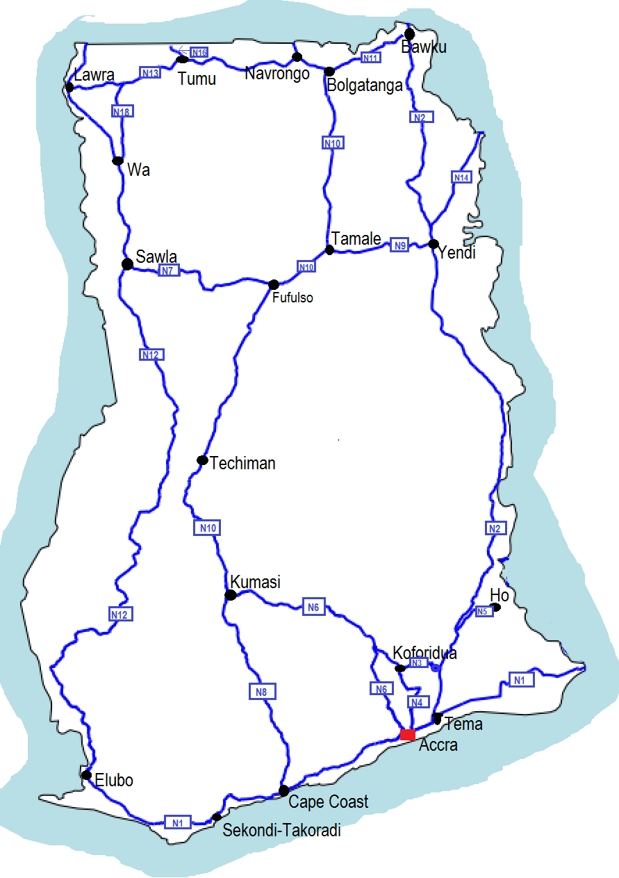
The N10 or National Highway 10 is a national highway in Ghana that begins at Kumasi and runs north to Burkina Faso, where it turns into the N5 of Burkina Faso. This makes it to one of the most important economical connections to Burkina Faso. At Tamale the N10 intersects with N9. At Bolgatanga the N10 intersects with N11. The N10 spans a distance of 578 kilometers. Route Major towns and cities along the route of the N10 include Kumasi, Techiman, Tamale, Bolgatanga, Navrongo and Paga. See also *Ghana Road Network Roads in Ghana form a network of varied quality and capacity. Responsibility for the road network differs between trunk and non-trunk routes. Trunk roads, which are the most important roads, are administered by the Ghana Highway Authority, which ... References Roads in Ghana {{Ghana-stub ... [...More Info...] [...Related Items...] OR: [Wikipedia] [Google] [Baidu] |
Ghana
Ghana (; tw, Gaana, ee, Gana), officially the Republic of Ghana, is a country in West Africa. It abuts the Gulf of Guinea and the Atlantic Ocean to the south, sharing borders with Ivory Coast in the west, Burkina Faso in the north, and Togo in the east.Jackson, John G. (2001) ''Introduction to African Civilizations'', Citadel Press, p. 201, . Ghana covers an area of , spanning diverse biomes that range from coastal savannas to tropical rainforests. With nearly 31 million inhabitants (according to 2021 census), Ghana is the List of African countries by population, second-most populous country in West Africa, after Nigeria. The capital and List of cities in Ghana, largest city is Accra; other major cities are Kumasi, Tamale, Ghana, Tamale, and Sekondi-Takoradi. The first permanent state in present-day Ghana was the Bono state of the 11th century. Numerous kingdoms and empires emerged over the centuries, of which the most powerful were the Kingdom of Dagbon in the north and ... [...More Info...] [...Related Items...] OR: [Wikipedia] [Google] [Baidu] |
N9 Road (Ghana)
N9 may refer to: Roads * N9 road (Belgium), a road connecting Brussels and Ostend, passing Aalst, Ghent, Eeklo and Bruges (see :nl:N9 (België)) * N9 road (France) * N9 road (Ireland) * N9 road (Netherlands), a road connecting Alkmaar and De Kooy * N9 road (South Africa), a road connecting George and Colesberg * N9 road (Switzerland) * Nebraska Highway 9, a state highway in the U.S. state of Nebraska Other * Fairey N.9, a British seaplane * Jero N° 9 Antwerpen 1911, a 1911 aeroplane * London Buses route N9 * N9, a postcode district in the N postcode area * N9, the Nokia N9 model N9-00, a MeeGo Linux phone * Negeri Sembilan, one of the 13 states in Malaysia * Netscape Navigator 9, a web browser created by Netscape Communications * Nonoxynol-9, a molecule * North Coast Aviation IATA airline designator *Northrop N-9, company designation of the Northrop YB-35 flying wing bomber *Northrop N-9M, research aircraft, built as a flying mockup In manufacturing and design, a mockup, ... [...More Info...] [...Related Items...] OR: [Wikipedia] [Google] [Baidu] |
Bolgatanga
Bolgatanga ( Frafra: ''''), colloquially known as ''Bolga'', is a town and the capital of the Bolgatanga Municipal District and Upper East Region of Ghana, adjacent to the border with Burkina Faso. Bolgatanga has over 2012 settlement and a population of about 66,685 people. Bolgatanga is 161 km (about 100 miles) to the north of Tamale. Bolgatanga lies in the Red Volta River Valley (which serves as a major migration route of elephants), with the White Volta River and the cliffs of the Gambaga Escarpment to the south of the town forming the southern boundary of the Upper East Region. History of Bolgatanga The name Bolgatanga (Bolbatanga) was derived from the Guresi words ''bolba'' "migrants" and ''tanŋa'' "pyramid." Historically Bolgatanga was situated at the southern terminus of the ancient Trans-Saharan trade route. The eastern route converged with the Sahelian route, near Bolgatanga. Along the route, handicrafts—especially straw baskets, hats and fans, as well as leat ... [...More Info...] [...Related Items...] OR: [Wikipedia] [Google] [Baidu] |
N11 Road (Ghana)
The N11 or National Highway 11 is a national highway in Ghana that begins at Bolgatanga in the Upper East Region ( N10) and runs east to Bawku, where it intersects with the N2. The N11 is 110.8 km long. Route Major towns and cities along the route of the N11 include Bolgatanga, Zuarungu, Zebilla and Bawku. See also *Ghana Road Network Roads in Ghana form a network of varied quality and capacity. Responsibility for the road network differs between trunk and non-trunk routes. Trunk roads, which are the most important roads, are administered by the Ghana Highway Authority, which ... References {{Reflist Roads in Ghana ... [...More Info...] [...Related Items...] OR: [Wikipedia] [Google] [Baidu] |
Kumasi
Kumasi (historically spelled Comassie or Coomassie, usually spelled Kumase in Twi) is a city in the Ashanti Region, and is among the largest metropolitan areas in Ghana. Kumasi is located in a rain forest region near Lake Bosomtwe, and is the commercial, industrial, and cultural capital of the historical Ashanti Empire. Kumasi is approximately north of the Equator and north of the Gulf of Guinea. Kumasi is alternatively known as "The Garden City" because of its many species of flowers and plants in the past. It is also called Oseikrom (Osei Tutu's the first town). Kumasi is the second-largest city in Ghana, after the capital, Accra. The Central Business District of Kumasi includes areas such as Adum, Bantama, Asawasi, Pampaso and Bompata (popularly called Roman Hill), with a concentration of banks, department stalls, and hotels. Economic activities in Kumasi include financial and commercial sectors, pottery, clothing and textiles. There is a significant timber processing ... [...More Info...] [...Related Items...] OR: [Wikipedia] [Google] [Baidu] |
Techiman
Techiman is a city and is the capital of Techiman Municipal and Bono East Region of Ghana. Techiman is a leading market town in South Ghana. Techiman is one of the two major cities and settlements of Bono East region. Techiman is home to West Africa's largest traditional market. Techiman has a settlement population of 104,212 people in 2013. Techiman is located at a historical crossroads of trade routes and the Tano River, and serves as capital of the Techiman Municipal District. History According to oral tradition, the Akans which constitute the largest ethnic group in Ghana, moved from ancient Bono State; a historical location known as Bono Manso, a suburb in Techiman Municipality. The Fantes (''an Akan people''), according to their oral tradition, migrated from Techiman to found the coastal Mankessim Kingdom that covers present Central region and Western regions in 1252. Others from the Akan people would later follow and formed their own states and city states, such as th ... [...More Info...] [...Related Items...] OR: [Wikipedia] [Google] [Baidu] |
Tamale, Ghana
Tamale (Dagbani : ), officially called Tamale Metropolitan Area is the capital city of the Northern Region of Ghana. Tamale is Ghana's third-largest city and an emerging investment hotspot in West Africa. It has a projected population of 950,124 according to the Tamale Metropolitan Assembly Official Website. It is the fastest-growing city in West Africa. It is located north of Accra. Most residents of Tamale are Muslims and Dagombas by tribe, as reflected by the multitude of mosques in Tamale, most notably the Central Mosque, Afa Ajura Mosque (Ambariyyah Mosque), Afa Basha mosque (Nuuria mosque) and The Ahmadiyyah Muslim mission Mosque. Tamale is located in the Northern Region of Ghana and more precisely in the Kingdom of Dagbon. The local (neighbourhood) chiefs and the district chief of Tamale are subservient to the Dagomba King in Yendi.The language of the people in Tamale is Dagbani. Due to its central location, Tamale serves as a hub for all administrative and commerci ... [...More Info...] [...Related Items...] OR: [Wikipedia] [Google] [Baidu] |
Navrongo
Navrongo is a town and the capital of Kassena-Nankana District in the Upper East Region of northern Ghana, adjacent to the border with Burkina Faso. Navrongo is the capital of Kassena-Nankana District – which is within the Upper East Region of northern Ghana. Navrongo has a 2012 settlement population of 27,306 people. Navrongo is an important market town, known for its cathedral and its grotto. Navrongo is located at . Navrongo's population in 2005 was estimated to be 25,470, and its population in 2012 was estimated to be 27,306. The terrain is flat and the ecology is typical of the Sahel – arid grassland with occasional shrubbery. The first ever Solar Plant with a capacity of 2 Megawatts in Ghana is located at Navrongo: Navrongo Solar Power Station. ''ghana.gov.gh''. History The ...[...More Info...] [...Related Items...] OR: [Wikipedia] [Google] [Baidu] |
Paga
Paga is a town in Upper East Region of Ghana, lying north of Bolgatanga. Paga is the capital of Kassena Nankana West District, a district in the Upper East Region in the northern part of Ghana. The town is located on the border of Burkina Faso and is 166 km south of Ouagadougou via the N5 highway, the main road linking Ghana and Burkina Faso. Majority of the people of Paga are kassena by tribe. Overview Paga is known for its sacred crocodile ponds, where most visitors are surprised that they can touch a live crocodile. Paga is a small town in the Upper East Region, and has a population of about 10,000. However, the entire population of Paga – including its outskirts – is over 100,000. Most of the inhabitants are farmers of the Kassena ethnic group, whose settlements and familial ties stretch over the colonial borders of Ghana into what is now Burkina Faso. The idea of different nationalities mean little to these people, who see their shared ancestry and ethnicity befo ... [...More Info...] [...Related Items...] OR: [Wikipedia] [Google] [Baidu] |
Ghana Road Network
Roads in Ghana form a network of varied quality and capacity. Responsibility for the road network differs between trunk and non-trunk routes. Trunk roads, which are the most important roads, are administered by the Ghana Highway Authority, which was established in 1974 to develop the trunk road network. Ghana's 13,367 km of trunk roads accounts for 33% of the total road network of 40,186 km. The Department of Feeder Roads is responsible for the construction and maintenance of feeder roads in Ghana, while responsibility for urban roads lies with the Department of Urban Roads. Road distances are shown in kilometers and Ghana speed limits are indicated in kilometers per hour (km/h). Generally, speed limits range from in urban areas, on Regional and Inter-Regional highways (R and IR routes), on National highways (N routes) and on motorways. Classification Trunk roads in Ghana are classified as N for National routes, R for Regional routes, and IR for Inter-Regional rou ... [...More Info...] [...Related Items...] OR: [Wikipedia] [Google] [Baidu] |

_p344_PLATE_9_-_COOMASSIE%2C_PART_OF_ADAM_STREET.jpg)

.jpg)
