|
Mysen Station
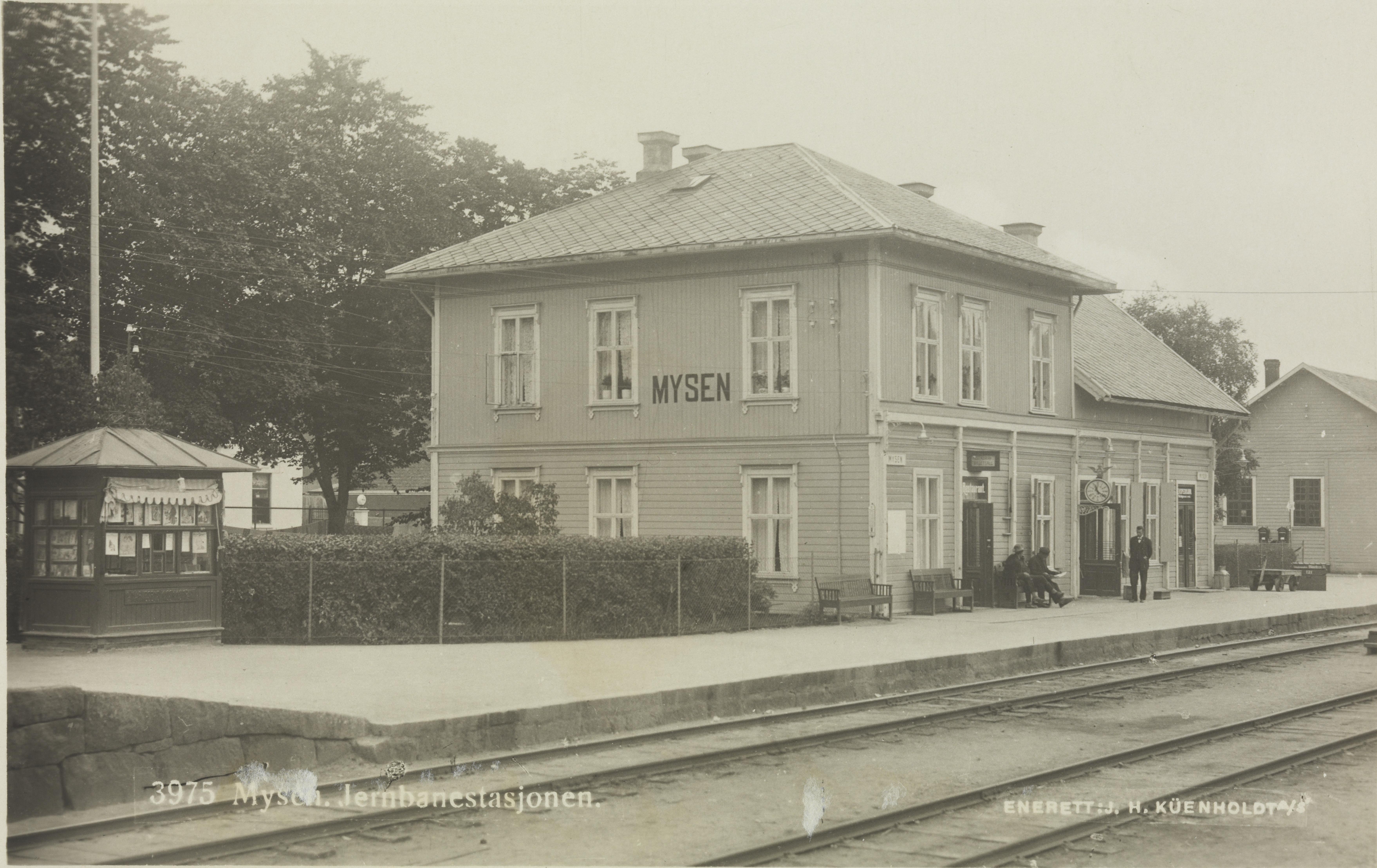
Mysen Station ( no, Mysen stasjon) is a railway station located at Mysen in Eidsberg, Norway. Situated from Oslo Central Station (Oslo S), it is served hourly by the L22 service of the Oslo Commuter Rail. It is the terminus of most L22 services. The station had 251,000 boarding and disembarking passengers in 2012. The station opened on 24 November 1882 with a station building designed by Balthazar Lange in Swiss chalet style. The town of Mysen grew up around the station, and soon features the municipal center, shopping and industry. A grain elevator was built in 1953. The original station was demolished in 1986 to make way for a building complex. The station platforms were modernized in 2014. History Discussion of a railway through Eidsberg was first debated in the municipal council on 5 January 1867. The municipality approved a grant of 20,000 Norwegian speciedaler on 25 January 1873. After it was decided in 1873 that the Østfold Line was to be built, the main route contr ... [...More Info...] [...Related Items...] OR: [Wikipedia] [Google] [Baidu] |
Mysen
Mysen is the administrative center of the municipality of Eidsberg in the county of Østfold in Norway. The town is named after the old farm of Mysen ( Norse ''Mysin'', from ''*Mosvin''), since the town is built on its ground. The first element is ''mosi'' m 'bog, marsh', the last element is '' vin '' m 'meadow, pasture'. The town's history Between 1920 and 1961, it was a separate municipality. Mysen became an independent municipality on 1 July 1920 when it was spun off from Eidsberg. On 1 January 1961 Mysen was merged again with Eidsberg. As with many other places in Eastern Norway Mysen has grown up around a railway station, after Østfold Line's Eastern Line opened in 1882. Today the station is an end stop for most local trains on the eastern line. Therefore, Mysen is a communication center for inner Østfold, with bus routes to most of the surrounding area, also Töcksfors in Sweden. The village had 6,084 inhabitants as of 1 January 2011. During the Second World War. there ... [...More Info...] [...Related Items...] OR: [Wikipedia] [Google] [Baidu] |
Grain Elevator
A grain elevator is a facility designed to stockpile or store grain. In the grain trade, the term "grain elevator" also describes a tower containing a bucket elevator or a pneumatic conveyor, which scoops up grain from a lower level and deposits it in a silo or other storage facility. In most cases, the term "grain elevator" also describes the entire elevator complex, including receiving and testing offices, weighbridges, and storage facilities. It may also mean organizations that operate or control several individual elevators, in different locations. In Australia, the term describes only the lifting mechanism. Before the advent of the grain elevator, grain was usually handled in bags rather than in bulk (large quantities of loose grain). Dart's Elevator was a major innovation. It was invented by Joseph Dart, a merchant, and Robert Dunbar, an engineer, in 1842 and 1843, in Buffalo, New York. Using the steam-powered flour mills of Oliver Evans as their model, they invented th ... [...More Info...] [...Related Items...] OR: [Wikipedia] [Google] [Baidu] |
Norwegian Resistance Movement
The Norwegian resistance (Norwegian: ''Motstandsbevegelsen'') to the occupation of Norway by Nazi Germany began after Operation Weserübung in 1940 and ended in 1945. It took several forms: *Asserting the legitimacy of the exiled government, and by implication the lack of legitimacy of Vidkun Quisling's pro-Nazi regime and Josef Terboven's military administration *The initial defence in Southern Norway, which was largely disorganised, but succeeded in allowing the government to escape capture *The more organised military defence and counter-attacks in parts of Western and Northern Norway, aimed at securing strategic positions and the evacuation of the government *Armed resistance, in the form of sabotage, commando raids, assassinations and other special operations during the occupation *Civil disobedience and unarmed resistance Asserting legitimacy of exiled Norwegian government The Norwegian government of Prime Minister Johan Nygaardsvold, with the exception of foreign mini ... [...More Info...] [...Related Items...] OR: [Wikipedia] [Google] [Baidu] |
Romerike
Romerike is a traditional district located north-east of Oslo, in what is today south-eastern Norway. It consists of the Viken municipalities Lillestrøm, Lørenskog, Nittedal, Rælingen and Aurskog-Høland in the southern end (Nedre Romerike), and Ullensaker, Gjerdrum, Nannestad, Nes, Eidsvoll and Hurdal in the northern end (Øvre Romerike). Etymology The Old Norse form of the name was ', but the name must be much older (see below). The first element is the genitive plural of ' m ("person from Romerike"); the final element is ' n ("kingdom, reich"; cf. Ringerike, Rånrike). In the '' Hversu Noregr byggdist'' and in '' Thorsteins saga Víkingssonar'', the name is attributed to the mythical king Raum the Old (''Raumr inn gamli''). According to the latter saga, the members of the family were big and ugly, and because of this big and ugly people were called "great Raumar". History The name Romerike may be derived ultimately from ''Raum elfr'', which was an old name for the ... [...More Info...] [...Related Items...] OR: [Wikipedia] [Google] [Baidu] |
Urskog–Høland Line
The Urskog–Høland Line ( no, Urskog–Hølandsbanen), also known as Tertitten, is a narrow gauge railway between Sørumsand and Skulerud in Norway. History The original line was long and was built in three stages: Urskogbanen opened in 1896, running from Bingsfossen to Bjørkelangen; Hølandsbanen from Bjørkelangen to Skulerud opened in 1898 and finally the line between Bingsfos and Sørumsand in 1903. Today part of the line is preserved as a museum at Sørumsand in Lillestrøm kommune. The railway company was headquartered at Bjørkelangen. The line was built in the least expensive way as a so-called tertiary railway with a gauge track. This gave the line its diminutive, affectionate nickname, "Tertitten". The railway was run as a privately owned joint stock company until 1945 when it was bought by the government and run by the Norwegian State Railways (NSB) under the name Aurskog-Hølandbanen. The basis for the railway lay mostly in forest and agriculture products. Lumbe ... [...More Info...] [...Related Items...] OR: [Wikipedia] [Google] [Baidu] |
Folkenborg
Folkenborg (sometimes known as Folkinsberg) is a former nobles estate from the 12th-13th century located .94 miles southeast of Mysen located in the Viken (county). It is famous for being the site where King Haakon IV of Norway was born. In 1225 Haakon stayed here during his war with Värmland which means that it was either a royal property or his own personal property. Since most of the royal property was inherited by Skule Bårdsson it is likely to have been a Patrimony probably from his mother Inga. Despite some spellings as -berg the proper spelling is -borg because berg would imply a mountain but there is none on the site. Instead it is more likely that there was a Borough A borough is an administrative division in various English-speaking countries. In principle, the term ''borough'' designates a self-governing walled town, although in practice, official use of the term varies widely. History In the Middle Ag ... (Borg) which could range from a walled settlement to a ... [...More Info...] [...Related Items...] OR: [Wikipedia] [Google] [Baidu] |
Glomma
The Glomma, or Glåma, is Norway's longest and most voluminous river. With a total length of , it has a drainage basin that covers fully 13% of Norway's surface area, all in the southern part of the country. Geography At its fullest length, the river runs from the lake Aursund near Røros in Trøndelag and runs into the Oslofjord at Fredrikstad. Major tributaries include the Vorma River, which drains Lake Mjøsa, joining the Glomma River at Årnes in Nes. The Lågen drains into Lake Mjøsa, collecting drainage from the large Gudbrandsdalen and significantly increasing the Glomma's flow. Because it flows through some of the richest forest districts, it has historically been Norway's leading log-floating river. The combination of raw materials, water power, and easy transport has over the centuries encouraged industry along the Glomma. Some of the country's largest manufacturing and processing concerns are found around its mouth, where supplies of timber and hydropower have been ... [...More Info...] [...Related Items...] OR: [Wikipedia] [Google] [Baidu] |
Ørje
Ørje is the administrative centre of Marker municipality, Norway, not far from the Swedish border. Its population (2013) is 1,881. Ørje was founded in the 1880s around a timber-processing mill. Engebret Soot had built the first Norwegian canal locks at Ørje in the years 1857-1860 ( :no:Ørje sluser). The total lift of the locks are 10 meters (30 feet) divided on 3 steps. The locks are situated between the lakes "Rødenessjøen" and "Øymarksjøen" as a part of the Halden Canal Waterway System. In the decades following World War II, Ørje developed substantial industry and commerce. Today, the service sector, including tourism have partly replaced manufacture and agriculture/forestry as the most important economic sectors. Ørje is known for its canal museum (''Haldenvassdragets Kanalmuseum'') and steamboat club, military fortifications from 1905 and locks. Ørje has also become well-known due to a pedestrian crossing sign installed in the village by the Swedish artists' c ... [...More Info...] [...Related Items...] OR: [Wikipedia] [Google] [Baidu] |
Moss, Norway
is a coastal town and a municipality in Viken county, Norway. The administrative centre of the municipality is the town of Moss. The city of Moss was established as a municipality on 1 January 1838 (see formannskapsdistrikt) and City in 1720. The rural municipality of Jeløy was merged with the city on 1 July 1943. The former municipality of Rygge was merged into it on January 1, 2020. Its administrative district covers areas east of the town, such as the island of Dillingøy in the lake Vansjø. Parts of the town are located on the peninsula of Jeløy. The city of Moss has 30,723 inhabitants (2012). Name The Old Norse form of the name was . It may be derived from an old root ''mer-'' which means to "divide" or "split". The adjacent topography shares similar etymology: * , Mosse-"marsh-river-border"+ (see , , Old Norse for river). The name is thought to be very old and the meaning of it is not clear. * , Mosse-"marsh-river-border"+ (Moss channel). * , Mosse-"marsh-river-bo ... [...More Info...] [...Related Items...] OR: [Wikipedia] [Google] [Baidu] |
Eidsberg Station
Eidsberg Station ( no, Eidsberg holdeplass) is a railway station of the Eastern Østfold Line located in at Finnestad in Eidsberg, Norway. Situated from Oslo Central Station (Oslo S), it is only served by extra rush-hour R22 service of the Oslo Commuter Rail. The station, which originally provided a passing loop, was designed by Balthazar Lange and opened on 24 November 1882. The passing loop was demolished in 1989 and the station unmanned. It was renovated as a heritage site in 2014. History Discussion of a railway through Eidsberg was first debated in the municipal council on 5 January 1867. The municipality approved a grant of 20,000 Norwegian speciedaler on 25 January 1873. After it was decided in 1873 that the Østfold Line was to be built, the main route controversy regarding the Eastern Line was whether it should run via Mysen, or take a straight line from Askim to Rakkestad. The railway engineers originally favored a bypass, but this was overruled by Parliament on 4 June ... [...More Info...] [...Related Items...] OR: [Wikipedia] [Google] [Baidu] |


