|
Muang Kham, Laos
Muang Kham is a small town in Xiangkhouang Province in northeastern Laos Laos (, ''Lāo'' )), officially the Lao People's Democratic Republic ( Lao: ສາທາລະນະລັດ ປະຊາທິປະໄຕ ປະຊາຊົນລາວ, French: République démocratique populaire lao), is a socialist .... It is located along Route 7 (Laos), east of Phonsavan, on the way to Nong Haet. The road between Muang Kham and Nong Haet is noted for its Thai Dam funerary shrines with white tombs, prayer flags and offerings. Healthcare The Kham District Hospital is located in Muang Kham. References Populated places in Xiangkhouang Province {{Laos-geo-stub ... [...More Info...] [...Related Items...] OR: [Wikipedia] [Google] [Baidu] |
Provinces Of Laos
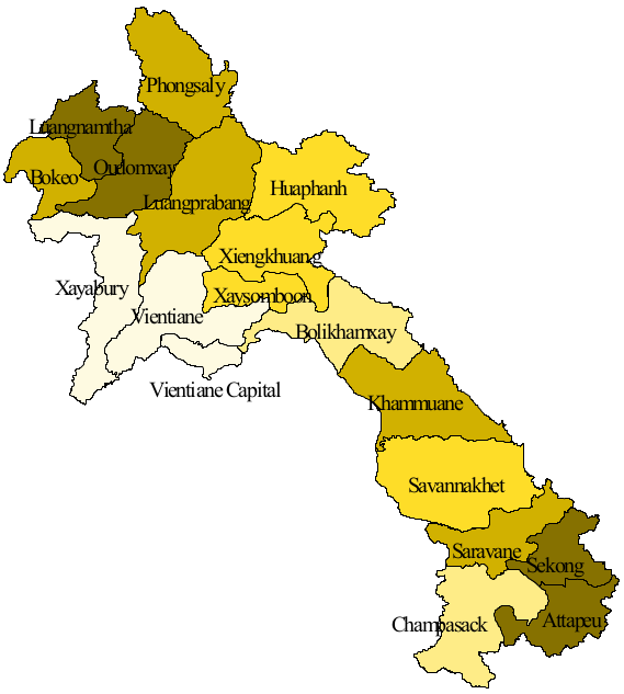
Laos, officially the ''Lao People's Democratic Republic'', is divided into 17 provinces ( Lao ແຂວງ, , , or ) and one prefecture, the Vientiane capital city municipality (ນະຄອນຫຼວງ, nakhon louang, or ''Na Kone Luang Vientiane''). The special administrative zone (ເຂດພິເສດ, ''khet phiset''), Xaisomboun, created in 1994, was dissolved on 13 January 2006. In 2013, parts of the former special administrative zone was reestablished as Xaisomboun province. Provinces and prefectures of Laos Population The population of each province in 2015 is given in the census data. History In 1989 Vientiane prefecture was split from Vientiane province and the capital of Vientiane province moved from Vientiane to Muang Phôn-Hông. In 1994 Xaisômboun khetphiset (special region) was formed from parts of the Bolikhamxai, Vientiane, and Xiangkhoang provinces. In 2006 Xaisomboun special region was dissolved and the Longsan, Xaysomboun, Phun, and Hom dist ... [...More Info...] [...Related Items...] OR: [Wikipedia] [Google] [Baidu] |
Xiangkhouang Province
Xiangkhouang ( Lao: ຊຽງຂວາງ, meaning 'Horizontal City') is a province of Laos on the Xiangkhoang Plateau, in the nation's northeast. The province has the distinction of being the most heavily bombed place on Earth. The province was originally known as the Principality of ''Muang Phuan'' (Muang Phouan / Xieng Khouang). Its present capital is Phonsavan. The population of the province as of the 2015 census was 244,684. Xiangkhouang province covers an area of and is mountainous. Apart from floodplains, the largest area of level land in the country is on the province's Xiangkhoang Plateau. The plateau is characterized by rolling hills and grassland whose elevation averages . The country's highest peak, Phou Bia (), rises at the south side of the plateau. Nam Et-Phou Louey is a National Biodiversity Conservation Area (NBCA) in the province, covering an area of 5,959 km2, and overlaps into Houaphanh and Luang Prabang provinces. The province's Plain of Jars was ... [...More Info...] [...Related Items...] OR: [Wikipedia] [Google] [Baidu] |
Köppen Climate Classification
The Köppen climate classification is one of the most widely used climate classification systems. It was first published by German-Russian climatologist Wladimir Köppen (1846–1940) in 1884, with several later modifications by Köppen, notably in 1918 and 1936. Later, the climatologist Rudolf Geiger (1894–1981) introduced some changes to the classification system, which is thus sometimes called the Köppen–Geiger climate classification system. The Köppen climate classification divides climates into five main climate groups, with each group being divided based on seasonal precipitation and temperature patterns. The five main groups are ''A'' (tropical), ''B'' (arid), ''C'' (temperate), ''D'' (continental), and ''E'' (polar). Each group and subgroup is represented by a letter. All climates are assigned a main group (the first letter). All climates except for those in the ''E'' group are assigned a seasonal precipitation subgroup (the second letter). For example, ''Af'' indi ... [...More Info...] [...Related Items...] OR: [Wikipedia] [Google] [Baidu] |
Humid Subtropical Climate
A humid subtropical climate is a zone of climate characterized by hot and humid summers, and cool to mild winters. These climates normally lie on the southeast side of all continents (except Antarctica), generally between latitudes 25° and 40° and are located poleward from adjacent tropical climates. It is also known as warm temperate climate in some climate classifications. Under the Köppen climate classification, ''Cfa'' and ''Cwa'' climates are either described as humid subtropical climates or warm temperate climates. This climate features mean temperature in the coldest month between (or ) and and mean temperature in the warmest month or higher. However, while some climatologists have opted to describe this climate type as a "humid subtropical climate", Köppen himself never used this term. The humid subtropical climate classification was officially created under the Trewartha climate classification. In this classification, climates are termed humid subtropical when the ... [...More Info...] [...Related Items...] OR: [Wikipedia] [Google] [Baidu] |
Laos
Laos (, ''Lāo'' )), officially the Lao People's Democratic Republic ( Lao: ສາທາລະນະລັດ ປະຊາທິປະໄຕ ປະຊາຊົນລາວ, French: République démocratique populaire lao), is a socialist state and the only landlocked country in Southeast Asia. At the heart of the Indochinese Peninsula, Laos is bordered by Myanmar and China to the northwest, Vietnam to the east, Cambodia to the southeast, and Thailand to the west and southwest. Its capital and largest city is Vientiane. Present-day Laos traces its historic and cultural identity to Lan Xang, which existed from the 14th century to the 18th century as one of the largest kingdoms in Southeast Asia. Because of its central geographical location in Southeast Asia, the kingdom became a hub for overland trade and became wealthy economically and culturally. After a period of internal conflict, Lan Xang broke into three separate kingdoms: Luang Phrabang, Vientiane and Champasak. In ... [...More Info...] [...Related Items...] OR: [Wikipedia] [Google] [Baidu] |
Route 7 (Laos)
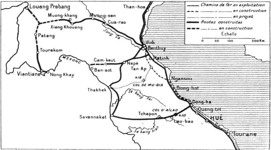
Route 7 of Laos, ເສັ້ນ ທາງ ເລກ 7 ຂອງປະເທດລາວ (ທ. 7) is a provincial road served from east to west in Xiangkhouang province, Laos. It runs from Nong Het in the east to Phoukhoune District in the west. This is where people change connections to go to Luang prabang or Vientiane. History Route 7 (Laos) is built in the early 1905 by a Resident, Mr. ''Sestier''. It started from Vinh to Cua-rao, Vietnam, then to Muong-sen and Tran-Ninh, the former capital of Xieng khouang at the time, in XiangKhouang province, Laos, for a distance of 402 kilometers. During construction, a credit of 300,000 piastres was granted by Mr. Beau, one of the Governor Generals of Indochina at the time. Subsequently, the road was abandoned due to costly maintenance and upkeep. Afterwards, in 1911, it was taken over by a vigorous administrator-creator, Mr. Barthelemy, government commissioner of the Laotian province of Tran-Ninh (Xiangkhouang Plateau), XiangKh ... [...More Info...] [...Related Items...] OR: [Wikipedia] [Google] [Baidu] |
Phonsavan
Phonsavan ( Lao: ໂພນສະຫວັນ), population 37,507, is the capital of Xiangkhouang Province. Phonsavan was built in the late-1970s and replaced the old Xiangkhouang (today: Muang Khoune) which was destroyed during the Second Indochina War. Phonsavan is known for the nearby Plain of Jars, a UNESCO World Heritage site. The main economic activities in Phonsavan are based on governmental administration, mining by Chinese and Australian companies, tourism, and the work of non-governmental organizations (NGOs) clearing unexploded ordnance (UXO). History While the origin of the Plain of Jars people is unknown, the recorded history of Xiangkhouang is interlinked with the Tai Phuan. The Tai Phuan or Phuan people are a Buddhist Tai-Lao ethnic group that migrated to Laos from southern China and by the 13th century had formed the independent principality Muang Phuan at the Plain of Jars with Xiangkhouang (the contemporary Muang Khoun) as the capital. They prospered from ... [...More Info...] [...Related Items...] OR: [Wikipedia] [Google] [Baidu] |
Nong Haet
Nong Het, also Nong Haet, Nonghet, Muang Nonghet or Nonghed, is a market town in Xiangkhouang Province in northeastern Laos, located about from the border with Vietnam. It is the principal town of Nong Het District. It is located along Route 7, east of Phonsavan, along the road which passes through Muang Kham and Ban Na Sala on the way to Nong Haet. Bus companies operating in the area have increased to cater for tourists. The population is primarily Hmong peoples. History Nong Het has a turbulent history of battles between the Ly and Moua warriors, Red Laotians and the Hmong. The Red Laotians once invaded, tying up local leaders and robbing the wealthy of the town. Historically, two Hmong families have shared power in Nong Het, the Lo clan and the Ly clan. In 1917, the French appointed Lo Bliayao of the Lo clan as chief of Non Het. The strategical position of Nong Het meant that it was an "important resupply and transshipment point" during the Indochinese and Vietnam War, a ... [...More Info...] [...Related Items...] OR: [Wikipedia] [Google] [Baidu] |


