|
Medchal District
Medchal−Malkajgiri district is a district in the Indian state of Telangana. Shamirpet is the headquarter of the district. It is the second most populous district with a population of 25 lakh and also 91.40% urbanized district in the state of Telangana, standing next only to Hyderabad district which has a population of 40 lakhs. The district shares boundaries with Hyderabad, Medak, Sangareddy, Y. Bhuvanagiri, Siddipet and Rangareddy districts.The most part of the district consist of Hyderabad City (GHMC) Geography The district is spread over an area of .It is situated 505 metres above sea level. The landmark consists of rocky terrain and monolithic rocks in the outskirts of the city. Demographics census of India, the district is the second most populous district in the state with a population of 2,440,073. Administrative divisions The district will have two revenue divisions of Keesara and Malkajgiri. They are sub-divided into 15 mandals. Sri V. Venkateswarlu, IAS ... [...More Info...] [...Related Items...] OR: [Wikipedia] [Google] [Baidu] |
Districts Of Telangana
The Indian state of Telangana has 33 districts, each headed by a District collector. History Telangana region of Hyderabad State consisted of 8 Districts in 1948 when it was inducted in Dominion of India; they are Hyderabad, Mahbubnagar, Medak, Nalgonda, Nizamabad, Adilabad, Karimnagar and Warangal districts. Khammam district was created by bifurcation of Warangal district on 1 October 1953. Andhra Pradesh was formed by merging Telangana region of Hyderabad State and Andhra state on 1 November 1956. Bhadrachalam division and Aswaraopet taluka parts was merged in Khammam district from Godavari districts for better Administration. Hyderabad district was split into Hyderabad Urban District and Hyderabad Rural District on 15 August 1978. Hyderabad Urban District was made by 4 Talukas are Charminar, Golkonda, Mushirabad and Secunderabad Talukas which consist of only MCH area, Secunderabad cantonment and Osmania University. Hyderabad rural district was later renamed as Ranga ... [...More Info...] [...Related Items...] OR: [Wikipedia] [Google] [Baidu] |
National Highway 44 (India)
National Highway 44 (NH 44) is a major north–south National Highway in India and is the longest in the country. It passes through the Union Territory of Jammu and Kashmir, in addition to the states of Punjab, Haryana, Delhi, Uttar Pradesh, Rajasthan, Madhya Pradesh, Maharashtra, Telangana, Andhra Pradesh, Karnataka, and Tamil Nadu. It came into being by merging seven national highways, in full or part, starting with the Jammu-Srinagar National Highway (former NH 1A) from Srinagar in Jammu and Kashmir, former NH 1 in Punjab and Haryana ending at Delhi, part of former NH 2 starting from Delhi and ending at Agra, former NH 3 (popularly known as Agra-Bombay National Highway) from Agra to Gwalior, former NH 75 and former NH 26 to Jhansi, and former NH 7 via Lakhnadon, Seoni, Nagpur, Hinganghat, Adilabad, Nirmal, Hyderabad, Kurnool, Anantapur,Chikkaballapur, Bangalore, Hosur, Krishnagiri, Dharmapuri, Salem, Namakkal, Karur, Dindigul, Madurai, Virudhunagar and Tirunelve ... [...More Info...] [...Related Items...] OR: [Wikipedia] [Google] [Baidu] |
2011 Census Of India
The 2011 Census of India or the 15th Indian Census was conducted in two phases, house listing and population enumeration. The House listing phase began on 1 April 2010 and involved the collection of information about all buildings. Information for National Population Register (NPR) was also collected in the first phase, which will be used to issue a 12-digit unique identification number to all registered Indian residents by Unique Identification Authority of India. The second population enumeration phase was conducted between 9 and 28 February 2011. Census has been conducted in India since 1872 and 2011 marks the first time biometric information was collected. According to the provisional reports released on 31 March 2011, the Indian population increased to 1.21 billion with a decadal growth of 17.70%. Adult literacy rate increased to 74.04% with a decadal growth of 9.21%. The motto of the census was 'Our Census, Our future'. Spread across 28 states and 8 union territories, t ... [...More Info...] [...Related Items...] OR: [Wikipedia] [Google] [Baidu] |
Greater Hyderabad Municipal Corporation
The Greater Hyderabad Municipal Corporation, commonly known as the GHMC is the civic body that oversees Hyderabad, the capital and largest city of the Indian state of Telangana. It is the local government for the cities of Hyderabad and Secunderabad. It is one of the largest municipal corporations in India with a population of 7.9 million and an area of 650 km². History Hyderabad Municipal Board and Chaderghat Municipal Board In 1869, Municipal administration was first introduced for the city of Hyderabad. The city of Hyderabad was divided into four and the suburbs of Chaderghat were divided into five divisions. The whole management of both the city and the suburbs was handled by the then City Police Commissioner, Kotwal-e-Baldia. In the same year, Sir Salar Jung-1, the then Prime Minister of Hyderabad State under the Nizam, has constituted the Department of Municipal and Road Maintenance. He also appointed a Municipal Commissioner for Hyderabad Board and Chaderg ... [...More Info...] [...Related Items...] OR: [Wikipedia] [Google] [Baidu] |
Rangareddy District
Ranga Reddy district ( R. R. district) is a district in the Indian state of Telangana. The district headquarters is located at Lakdikapool, Hyderabad. The district was named after the former deputy chief minister of the United Andhra Pradesh, K. V. Ranga Reddy. The district shares boundaries with Nalgonda, Yadadri Bhuvanagiri, Hyderabad, Medchal–Malkajgiri, Nagarkurnool, Mahabubnagar, Sangareddy and Vikarabad districts. History The district was formed in 1978 when it was split from Hyderabad district. Originally named Hyderabad Rural district, it was renamed after Konda Venkata Ranga Reddy, a freedom fighter who fought for the independence of Telangana from the Nizams and who went on to become the deputy chief minister of Andhra Pradesh. In 2016, it was carved out during the district's reorganisation to create the new Vikarabad district and Medchal–Malkajgiri district. Geography Ranga Reddy District occupies an area of approximately . A freshwater reservoir, called ... [...More Info...] [...Related Items...] OR: [Wikipedia] [Google] [Baidu] |
Siddipet District
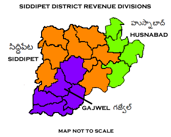
Siddipet district is a district located in the northern region of the Indian state of Telangana. Its headquarters is Siddipet. This district contains a part of the Hyderabad Metropolitan Region( Markook Mulugu Wargal) The district shares boundaries with Jangaon, Sircilla, Karimnagar, Kamareddy, Hanamkonda, Yadadri, Medhchal and Medak districts. Geography This district is bounded by Rajanna Sircilla district in the north, Karimnagar district in the northeast, Jangaon district in the east, Yadadri Bhuvanagiri district in the south, Medchal district in the southwest, Medak district in the west and Kamareddy district in the northwest. District administration The collector of Siddipet district is M. Hanmantha Rao, appointed on 16 November 2021, succeeding P. Venkatrami Reddy, who submitted his resignation to join politics. Administrative divisions The district will have three revenue divisions of Gajwel, Siddipet and Husnabad Husnabad is a town in the ... [...More Info...] [...Related Items...] OR: [Wikipedia] [Google] [Baidu] |
Bhuvanagiri District
Yadadri Bhuvanagiri District, is a district in the Indian state of Telangana. The administrative headquarters is located at Bhuvanagiri Town. The district shares boundaries with Suryapet, Nalgonda, Jangaon, Siddipet, Medchal-Malkajgiri and Rangareddy districts. It was carved out of Nalgonda district on 11 October 2016 during a large reorganization of the districts of Telangana. Geography The district is spread over an area of . Demographics Census of India, the district has a population of 726,465. According to the 2011 census, 90.54% of the district speaks Telugu, 4.97% Lambadi and 3.42% Urdu. Major Towns * Bhuvanagiri *Choutuppal *Alair *Mothkur Notable places in District *Bhuvanagiri Fort in Bhuvanagiri *Kolanupaka Temple in Alair - 33 km from Bhuvanagiri *Kunda Sathyanarayana Kala Dhamam-13 km from Bhuvanagiri *Yadagirigutta temple -16 km from Bhuvanagiri *Ramaneswaram temple in Nagireddypally-15 km from Bhuvanagiri Administrative ... [...More Info...] [...Related Items...] OR: [Wikipedia] [Google] [Baidu] |
Sangareddy District
Sangareddy district, is a List of districts of Telangana, district in the Indian state of Telangana. This district contains a part of the Hyderabad Metropolitan Region. The district shares boundaries with Medak district, Medak, Medchal–Malkajgiri, Medchal, Vikarabad district, Vikarabad, Kamareddy district, Kamareddy and Rangareddy district, Rangareddy districts and with the state boundary of Karnataka. Geography The district is spread over an area of . Demographics 2011 census of India, Census of India, the district has a population of 1,495,503. Scheduled Castes and Scheduled Tribes are 17.96% and 5.70% of the population respectively. Hindus are 81.44% while Muslims are 16.15% and Christians are 1.56% of the population. Language Administrative divisions The district has four List of revenue divisions in Telangana, revenue divisions of Narayankhed, Sangareddy, Zaheerabad, Andole–Jogipet which are sub-divided into 27 mandals. M. Hanumantha Rao is the present colle ... [...More Info...] [...Related Items...] OR: [Wikipedia] [Google] [Baidu] |
Medak District
Medak district is a district located in the Indian state of Telangana. Medak is the district headquarters. The district shares boundaries with Sangareddy, Kamareddy, Siddipet and Medchal districts. History Traces of Neolithic and Megalithic culture was found at Edithanur and Wargal village hillocks in the district. Rock paintings were found at Edithanur boulders and Hastallapur rocks. Nizam state In 20th century Medak district was a part of Nizam princely State before independence and merged into Hyderabad State in Independent India and presently a district of Telangana. Qutub Shahis named it as Gulshanabad which means '"city of gardens'" due to its luscious greenery. Geography The district is spread over an area of . Demographics As of the 2011 Census of India, the district has a population of 767,428. Economy In 2006 the Indian government named Medak one of the country's 250 most backward districts (out of a total of 640). It is one of the thirteen districts ... [...More Info...] [...Related Items...] OR: [Wikipedia] [Google] [Baidu] |
Hyderabad District, India
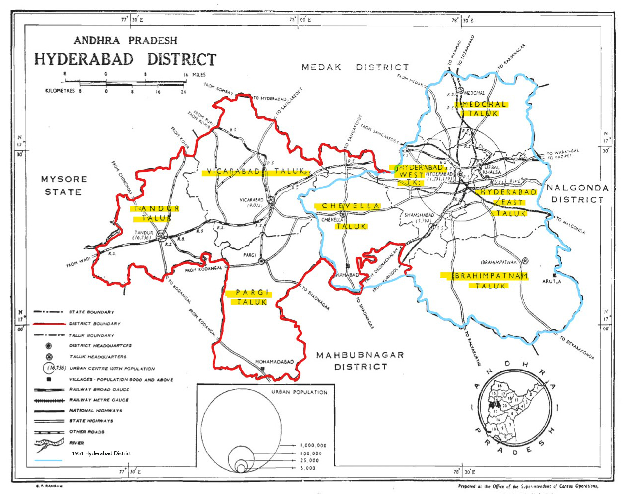
Hyderabad district is a most populous district in the state of Telangana in India that contains a part of the metropolitan area of Hyderabad. It is headed by a district collector who is drawn from the IAS cadre and is appointed by the state government. It is the smallest of all the districts in the state, but has the highest human density. Old MCH area, which is central region of Hyderabad city comes under this district.The district share boundaries with Rangareddy and Medhchal districts. History Hyderabad district was formed in 1948 after Operation Polo by merging Atraf-a-Balda District and Baghat District. Baghat was previously a Taluk in Atraf-e-Balda District, and was made a separate district in 1931–34 under the subedar of Medak division. After formation of Andhra Pradesh by merging Telugu speaking of Hyderabad state in 1956 Hyderabad district boundary was altered Tandur Taluka which is Telugu speaking region of Gulbarga district was merged in Hyderabad district and ... [...More Info...] [...Related Items...] OR: [Wikipedia] [Google] [Baidu] |
Indian State
India is a federal union comprising 28 states and 8 union territories, with a total of 36 entities. The states and union territories are further subdivided into districts and smaller administrative divisions. History Pre-independence The Indian subcontinent has been ruled by many different ethnic groups throughout its history, each instituting their own policies of administrative division in the region. The British Raj mostly retained the administrative structure of the preceding Mughal Empire. India was divided into provinces (also called Presidencies), directly governed by the British, and princely states, which were nominally controlled by a local prince or raja loyal to the British Empire, which held ''de facto'' sovereignty ( suzerainty) over the princely states. 1947–1950 Between 1947 and 1950 the territories of the princely states were politically integrated into the Indian union. Most were merged into existing provinces; others were organised into ... [...More Info...] [...Related Items...] OR: [Wikipedia] [Google] [Baidu] |
District
A district is a type of administrative division that, in some countries, is managed by the local government. Across the world, areas known as "districts" vary greatly in size, spanning regions or counties, several municipalities, subdivisions of municipalities, school district, or political district. By country/region Afghanistan In Afghanistan, a district (Persian ps, ولسوالۍ ) is a subdivision of a province. There are almost 400 districts in the country. Australia Electoral districts are used in state elections. Districts were also used in several states as cadastral units for land titles. Some were used as squatting districts. New South Wales had several different types of districts used in the 21st century. Austria In Austria, the word is used with different meanings in three different contexts: * Some of the tasks of the administrative branch of the national and regional governments are fulfilled by the 95 district administrative offices (). The area a dis ... [...More Info...] [...Related Items...] OR: [Wikipedia] [Google] [Baidu] |


