|
Måløy Bridge
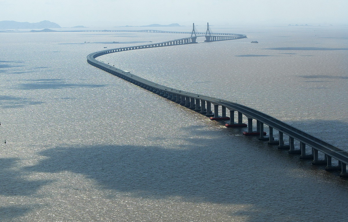
The Måløy Bridge ( no, Måløybrua) is a cantilever road bridge in Kinn Municipality in Vestland county, Norway. The bridge connects the village area of Degnepoll on the mainland and the town of Måløy on the island of Vågsøy. The bridge carries Norwegian national road 15 over the Måløystraumen strait and Måløy island. The bridge is long, the longest spans are , and the maximum clearance to the sea is . In total, the bridge has 34 spans. Construction started in 1971, and it was officially opened by King Olav V on 11 July 1974, although the bridge was actually opened for traffic in December 1973. King Olav came to the opening by ship, returning from a visit to Iceland. The opening of the bridge had to be postponed for a day because the Royal Yacht got delayed by bad weather while at sea. The Måløy Bridge was the longest bridge in Norway at the time of its opening. It cost to construct and was a toll bridge until 1984. The bridge is built to stand wind up to , h ... [...More Info...] [...Related Items...] OR: [Wikipedia] [Google] [Baidu] |
Måløy
Måløy () is a town in the municipality of Kinn in Vestland county, Norway. Måløy is located on the southeastern side of the island of Vågsøy, about northeast of the village of Holvika and about south of the village of Raudeberg. The Måløy Bridge connects the town centre to the area of Deknepollen on the mainland. Sør-Vågsøy Church is located in Måløy. Måløy is one of the most important fishing ports in Norway. In 1997, Måløy was granted town status by the municipality. The town has a population (2018) of 3,283 and a population density of . Prior to 2020, the town was also the administrative centre of the old Vågsøy Municipality. History Måløy was founded as a trading center on the small island of Moldøen, or Måløya, on the Ulvesundet strait between Vågsøy island and the mainland. As trade flourished, the town gradually moved to the larger island of Vågsøy, while keeping the name of the smaller island. This is the cause of some confusion, alth ... [...More Info...] [...Related Items...] OR: [Wikipedia] [Google] [Baidu] |
Iceland
Iceland ( is, Ísland; ) is a Nordic island country in the North Atlantic Ocean and in the Arctic Ocean. Iceland is the most sparsely populated country in Europe. Iceland's capital and largest city is Reykjavík, which (along with its surrounding areas) is home to over 65% of the population. Iceland is the biggest part of the Mid-Atlantic Ridge that rises above sea level, and its central volcanic plateau is erupting almost constantly. The interior consists of a plateau characterised by sand and lava fields, mountains, and glaciers, and many glacial rivers flow to the sea through the lowlands. Iceland is warmed by the Gulf Stream and has a temperate climate, despite a high latitude just outside the Arctic Circle. Its high latitude and marine influence keep summers chilly, and most of its islands have a polar climate. According to the ancient manuscript , the settlement of Iceland began in 874 AD when the Norwegian chieftain Ingólfr Arnarson became the first p ... [...More Info...] [...Related Items...] OR: [Wikipedia] [Google] [Baidu] |
Kinn
Kinn is a municipality in Vestland county, Norway. It was established on 1 January 2020. It is in the traditional districts of Nordfjord and Sunnfjord. The municipality is the only non-contiguous municipality in Norway since the municipality of Bremanger lies in between the north and south parts of Kinn. The administrative centres of the municipality is the two cities of Florø and Måløy. Some villages in the municipality include Rognaldsvåg, Stavang, Grov, Norddalsfjord, Nyttingnes, Steinhovden, Brandsøy, Deknepollen, Holvika, Kvalheim, Langeneset, Raudeberg, Refvika, Silda, Tennebø, Vedvika, and Vågsvåg. Historically, there was another municipality of Kinn in Norway that existed from 1838 until 1964. The "old" Kinn roughly corresponded to the southern part of the "new" municipality of Kinn. The municipality is the 142nd largest by area out of the 356 municipalities in Norway. Kinn is the 74th most populous municipality in Norway with a population of 17,131. The ... [...More Info...] [...Related Items...] OR: [Wikipedia] [Google] [Baidu] |
Cantilever Bridges
A cantilever bridge is a bridge built using structures that project horizontally into space, supported on only one end (called cantilevers). For small footbridges, the cantilevers may be simple beams; however, large cantilever bridges designed to handle road or rail traffic use trusses built from structural steel Structural steel is a category of steel used for making construction materials in a variety of shapes. Many structural steel shapes take the form of an elongated beam having a profile of a specific cross section. Structural steel shapes, sizes, ..., or box girders built from prestressed concrete. The steel truss cantilever bridge was a major engineering breakthrough when first put into practice, as it can span distances of over , and can be more easily constructed at difficult crossings by virtue of using little or no falsework. Origins Civil engineer, Engineers in the 19th century understood that a bridge that was continuous across multiple supports would dis ... [...More Info...] [...Related Items...] OR: [Wikipedia] [Google] [Baidu] |
Bridges Completed In 1973
A bridge is a structure built to span a physical obstacle (such as a body of water, valley, road, or rail) without blocking the way underneath. It is constructed for the purpose of providing passage over the obstacle, which is usually something that is otherwise difficult or impossible to cross. There are many different designs of bridges, each serving a particular purpose and applicable to different situations. Designs of bridges vary depending on factors such as the function of the bridge, the nature of the terrain where the bridge is constructed and anchored, and the material used to make it, and the funds available to build it. The earliest bridges were likely made with fallen trees and stepping stones. The Neolithic people built boardwalk bridges across marshland. The Arkadiko Bridge (dating from the 13th century BC, in the Peloponnese) is one of the oldest arch bridges still in existence and use. Etymology The ''Oxford English Dictionary'' traces the origin of the wo ... [...More Info...] [...Related Items...] OR: [Wikipedia] [Google] [Baidu] |
Bridges In Vestland
A bridge is a structure built to span a physical obstacle (such as a body of water, valley, road, or rail) without blocking the way underneath. It is constructed for the purpose of providing passage over the obstacle, which is usually something that is otherwise difficult or impossible to cross. There are many different designs of bridges, each serving a particular purpose and applicable to different situations. Designs of bridges vary depending on factors such as the function of the bridge, the nature of the terrain where the bridge is constructed and anchored, and the material used to make it, and the funds available to build it. The earliest bridges were likely made with fallen trees and stepping stones. The Neolithic people built boardwalk bridges across marshland. The Arkadiko Bridge (dating from the 13th century BC, in the Peloponnese) is one of the oldest arch bridges still in existence and use. Etymology The ''Oxford English Dictionary'' traces the origin of the ... [...More Info...] [...Related Items...] OR: [Wikipedia] [Google] [Baidu] |
List Of Bridges By Length
This is a list of the world's longest bridges that are more than in length sorted by their full length above land and water. The main span is the longest span without any ground support. '' Note: There is no standard way to measure the total length of a bridge. Some bridges are measured from the beginning of the entrance ramp to the end of the exit ramp. Some are measured from shoreline to shoreline. Yet others use the length of the total construction involved in building the bridge. Since there is no standard, no ranking of a bridge should be assumed because of its position in the list. Additionally, numbers are merely estimates and measures in U.S. customary units (feet) may be imprecise due to conversion rounding.'' Completed Under construction See also * List of spans * List of longest arch bridge spans ** List of longest masonry arch bridge spans * List of longest cantilever bridge spans * List of longest cable-stayed bridge spans * List of longest continuous ... [...More Info...] [...Related Items...] OR: [Wikipedia] [Google] [Baidu] |
List Of Bridges
The list of bridges is a link page for any bridges that are notable enough to have an article, or that are likely to have an article in the future, sorted alphabetically by country. Lists of bridges by country Afghanistan Albania Algeria * Ouadi El Roukham Bridge Andorra Argentina *General Artigas Bridge *General Belgrano Bridge *Ingeniero Ballester Dam *Integration Bridge * Libertador General San Martín Bridge * Neuquén-Cipolletti bridges * Paso de los Libres – Uruguaiana International Bridge *Puente de la Mujer * Puente Transbordador * Puente Valentín Alsina *Rosario-Victoria Bridge *Salto Grande Bridge *San Roque González de Santa Cruz Bridge * Tancredo Neves Bridge *Zárate–Brazo Largo Bridge Armenia Aruba Australia * Albert Bridge, Brisbane *Alexandra Bridge, Rockhampton *Alfords Point Bridge, Sydney *Algebuckina Bridge, near Oodnadatta, South Australia *Andrew Nixon Bridge, St George *Anzac Bridge, Sydney *Batman Bridge, Launceston * Birkenhead Bri ... [...More Info...] [...Related Items...] OR: [Wikipedia] [Google] [Baidu] |
List Of Bridges In Norway By Length
This is a list of the bridges in Norway listed by their full length above water or land. Bridges {, class="wikitable sortable" , - bgcolor="#efefef" !align="left", !! align="left", Name !! Length (metres) !! Span (metres) !! Completed !! align="left", County , - , , , Drammen Bridge , , align="right" , 1,892 , , align="right" , 60 , , align="center" , 1975 , , Buskerud , - , , , Nordhordland Bridge , , align="right" , 1,614 , , align="right" , 172 , , align="center" , 1994 , , Hordaland , - , , Hålogaland Bridge , align="right" , 1,533 , align="right" , 1,145 , align="center" , 2018 , Nordland , - , , , Sannesund Bridge , , align="right" , 1,528 , , align="right" , 139 , , align="center" , 1978 , , Østfold , - , , , Mjøsa Bridge , , align="right" , 1,421 , , align="right" , 69 , , align="center" , 1985 , , Hedmark/Oppland , - , , , Hardanger Bridge , , align="right" , 1,380 , , align="right" , 1310 , , ali ... [...More Info...] [...Related Items...] OR: [Wikipedia] [Google] [Baidu] |
List Of Bridges In Norway
This is a list of bridges and viaducts in Norway, including those for pedestrians and vehicular traffic. Historical and architectural interest bridges Major road and railway bridges This table presents the structures with spans greater than 200 meters (non-exhaustive list). {{row indexer, {, class="wikitable sortable" , - ! class="unsortable", ! scope=col , ! scope=col , Name ! scope=col , Span ! scope=col , Length ! scope=col width="115" , Type ! scope=col width="115" , Carries''Crosses'' ! scope=col , Opened ! scope=col , Location ! scope=col , County ! class="unsortable", Ref. , - , , , _row_count, , Hardanger Bridge, , {{convert, 1310, m, ft, abbr=on, , {{convert, 1373, m, ft, abbr=on, , {{Sort, S, SuspensionSteel box girder deck, concrete pylons, , {{center, National Road 7 National Road 13''Hardangerfjord'', , 2013, , Bruravik–Brimnes{{Coord, 60, 28, 43.5, N, 6, 49, 49.8, E, type:landmark, display=inline, name=Hardanger Bridge, , Vestland, , {{cite web , url= ... [...More Info...] [...Related Items...] OR: [Wikipedia] [Google] [Baidu] |
Wind
Wind is the natural movement of air or other gases relative to a planet's surface. Winds occur on a range of scales, from thunderstorm flows lasting tens of minutes, to local breezes generated by heating of land surfaces and lasting a few hours, to global winds resulting from the difference in absorption of solar energy between the climate zones on Earth. The two main causes of large-scale atmospheric circulation are the differential heating between the equator and the poles, and the rotation of the planet (Coriolis effect). Within the tropics and subtropics, thermal low circulations over terrain and high plateaus can drive monsoon circulations. In coastal areas the sea breeze/land breeze cycle can define local winds; in areas that have variable terrain, mountain and valley breezes can prevail. Winds are commonly classified by their spatial scale, their speed and direction, the forces that cause them, the regions in which they occur, and their effect. Winds have various asp ... [...More Info...] [...Related Items...] OR: [Wikipedia] [Google] [Baidu] |
Toll Bridge
A toll bridge is a bridge where a monetary charge (or ''toll'') is required to pass over. Generally the private or public owner, builder and maintainer of the bridge uses the toll to recoup their investment, in much the same way as a toll road. History The practice of collecting tolls on bridges harks back to the days of ferry crossings where people paid a fee to be ferried across stretches of water. As boats became impractical to carry large loads, ferry operators looked for new sources of revenue. Having built a bridge, they hoped to recoup their investment by charging tolls for people, animals, vehicles, and goods to cross it. The original London Bridge across the river Thames opened as a toll bridge, but an accumulation of funds by the charitable trust that operated the bridge (Bridge House Estates) saw that the charges were dropped. Using interest on its capital assets, the trust now owns and runs all seven central London bridges at no cost to taxpayers or users. In t ... [...More Info...] [...Related Items...] OR: [Wikipedia] [Google] [Baidu] |


