|
Mountgerald
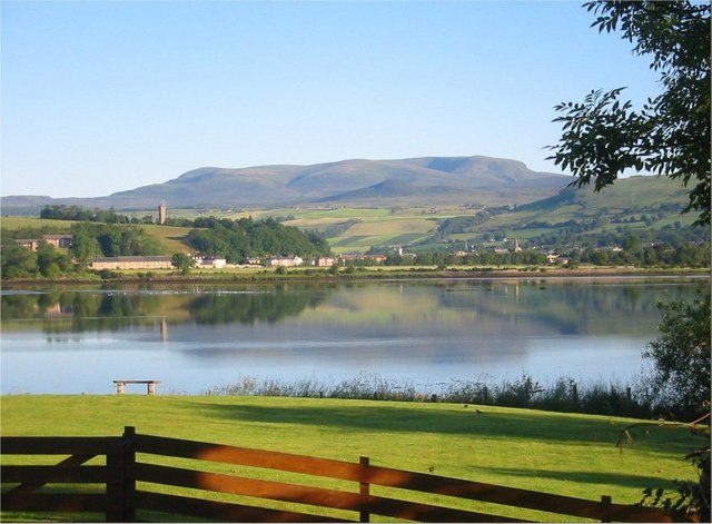
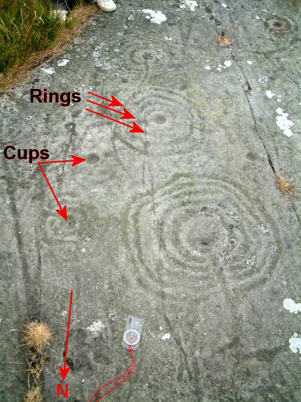
Mountgerald ( gd, An Claon) is a small hamlet which lies close to the head of the Cromarty Firth, on the west coast. It is northeast of Dingwall, in the western edge of Ross-shire, Scottish Highlands and is in the Scottish council area of Highland. A set of cup and ring mark Cup and ring marks or cup marks are a form of prehistoric art found in the Atlantic seaboard of Europe (Ireland, Wales, Northern England, Scotland, France (Brittany), Portugal, and Spain ( Galicia) – and in Mediterranean Europe – Italy (in Al ...ed stones was found in the area in 1864. References Populated places in Ross and Cromarty {{Highland-geo-stub ... [...More Info...] [...Related Items...] OR: [Wikipedia] [Google] [Baidu] |
Highland (council Area)
Highland ( gd, A' Ghàidhealtachd, ; sco, Hieland) is a council area in the Scottish Highlands and is the largest local government area in the United Kingdom. It was the 7th most populous council area in Scotland at the 2011 census. It shares borders with the council areas of Aberdeenshire, Argyll and Bute, Moray and Perth and Kinross. Their councils, and those of Angus and Stirling, also have areas of the Scottish Highlands within their administrative boundaries. The Highland area covers most of the mainland and inner-Hebridean parts of the historic counties of Inverness-shire and Ross and Cromarty, all of Caithness, Nairnshire and Sutherland and small parts of Argyll and Moray. Despite its name, the area does not cover the entire Scottish Highlands. Name Unlike the other council areas of Scotland, the name ''Highland'' is often not used as a proper noun. The council's website only sometimes refers to the area as being ''Highland'', and other times as being ''the Hig ... [...More Info...] [...Related Items...] OR: [Wikipedia] [Google] [Baidu] |
Dingwall
Dingwall ( sco, Dingwal, gd, Inbhir Pheofharain ) is a town and a royal burgh in the Highland council area of Scotland. It has a population of 5,491. It was an east-coast harbour that now lies inland. Dingwall Castle was once the biggest castle north of Stirling. On the town's present-day outskirts lies Tulloch Castle, parts of which may date back to the 12th century. In 1411 the Battle of Dingwall is said to have taken place between the Clan Mackay and the Clan Donald. History Its name, derived from the Scandinavian (field or meeting-place of the ''thing'', or local assembly; compare Tynwald, Tingwall, Thingwall in the British Isles alone, plus many others across northern Europe), preserves the Viking connections of the town; Gaels call it (), meaning "the mouth of the Peffery" or meaning "cabbage town". The site of the , and of the medieval Moothill, thought to have been established by the Vikings after they invaded in the 8th century, lies beneath the Cromartie memor ... [...More Info...] [...Related Items...] OR: [Wikipedia] [Google] [Baidu] |
Hamlet (place)
A hamlet is a human settlement that is smaller than a town or village. Its size relative to a Parish (administrative division), parish can depend on the administration and region. A hamlet may be considered to be a smaller settlement or subdivision or satellite entity to a larger settlement. The word and concept of a hamlet has roots in the Anglo-Norman settlement of England, where the old French ' came to apply to small human settlements. Etymology The word comes from Anglo-Norman language, Anglo-Norman ', corresponding to Old French ', the diminutive of Old French ' meaning a little village. This, in turn, is a diminutive of Old French ', possibly borrowed from (West Germanic languages, West Germanic) Franconian languages. Compare with modern French ', Dutch language, Dutch ', Frisian languages, Frisian ', German ', Old English ' and Modern English ''home''. By country Afghanistan In Afghanistan, the counterpart of the hamlet is the Qila, qala (Dari language, Dari: ... [...More Info...] [...Related Items...] OR: [Wikipedia] [Google] [Baidu] |
Cromarty Firth
The Cromarty Firth (; gd, Caolas Chrombaidh ; literally "kyles /nowiki>straits.html"_;"title="strait.html"_;"title="/nowiki>strait">/nowiki>straits">strait.html"_;"title="/nowiki>strait">/nowiki>straitsof_Cromarty.html" ;"title="strait">/nowiki>straits.html" ;"title="strait.html" ;"title="/nowiki>strait">/nowiki>straits">strait.html" ;"title="/nowiki>strait">/nowiki>straitsof Cromarty">strait">/nowiki>straits.html" ;"title="strait.html" ;"title="/nowiki>strait">/nowiki>straits">strait.html" ;"title="/nowiki>strait">/nowiki>straitsof Cromarty") is an arm of the Moray Firth in Scotland. Geography The entrance to the Cromarty Firth is guarded by two precipitous headlands; the one on the north high and the one on the south high — called " The Sutors" from a fancied resemblance to a couple of shoemakers (in Scots, ''souters'') bent over their lasts. From the Sutors the Firth extends inland in a westerly and then south-westerly direction for a distance of . Excepting be ... [...More Info...] [...Related Items...] OR: [Wikipedia] [Google] [Baidu] |
Ross-shire
Ross-shire (; gd, Siorrachd Rois) is a historic county in the Scottish Highlands. The county borders Sutherland to the north and Inverness-shire to the south, as well as having a complex border with Cromartyshire – a county consisting of numerous enclaves or exclaves scattered throughout Ross-shire's territory. Ross-shire includes most of Ross along with Lewis in the Outer Hebrides. Dingwall is the traditional county town. The area of Ross-shire is based on that of the historic province of Ross, but with the exclusion of the many enclaves that form Cromartyshire. For shreival purposes the area was first separated from the authority of the sheriff of Inverness by Act of Parliament during the reign of King James IV, the sheriff to sit at Tain or Dingwall. Sheriffs were seldom appointed, and further acts of 1649 and 1661 restated its separation from Inverness. The 1661 act also clarified the area encompassed, based on the pre-Reformation Diocese of Ross. Sir George ... [...More Info...] [...Related Items...] OR: [Wikipedia] [Google] [Baidu] |
Scottish Highlands
The Highlands ( sco, the Hielands; gd, a’ Ghàidhealtachd , 'the place of the Gaels') is a historical region of Scotland. Culturally, the Highlands and the Lowlands diverged from the Late Middle Ages into the modern period, when Lowland Scots replaced Scottish Gaelic throughout most of the Lowlands. The term is also used for the area north and west of the Highland Boundary Fault, although the exact boundaries are not clearly defined, particularly to the east. The Great Glen divides the Grampian Mountains to the southeast from the Northwest Highlands. The Scottish Gaelic name of ' literally means "the place of the Gaels" and traditionally, from a Gaelic-speaking point of view, includes both the Western Isles and the Highlands. The area is very sparsely populated, with many mountain ranges dominating the region, and includes the highest mountain in the British Isles, Ben Nevis. During the 18th and early 19th centuries the population of the Highlands rose to around 300,000, but ... [...More Info...] [...Related Items...] OR: [Wikipedia] [Google] [Baidu] |
Scotland
Scotland (, ) is a country that is part of the United Kingdom. Covering the northern third of the island of Great Britain, mainland Scotland has a border with England to the southeast and is otherwise surrounded by the Atlantic Ocean to the north and west, the North Sea to the northeast and east, and the Irish Sea to the south. It also contains more than 790 islands, principally in the archipelagos of the Hebrides and the Northern Isles. Most of the population, including the capital Edinburgh, is concentrated in the Central Belt—the plain between the Scottish Highlands and the Southern Uplands—in the Scottish Lowlands. Scotland is divided into 32 administrative subdivisions or local authorities, known as council areas. Glasgow City is the largest council area in terms of population, with Highland being the largest in terms of area. Limited self-governing power, covering matters such as education, social services and roads and transportation, is devolved from the Scott ... [...More Info...] [...Related Items...] OR: [Wikipedia] [Google] [Baidu] |
Highland Council Area
Highland ( gd, A' Ghàidhealtachd, ; sco, Hieland) is a council area in the Scottish Highlands and is the largest local government area in the United Kingdom. It was the 7th most populous council area in Scotland at the 2011 census. It shares borders with the council areas of Aberdeenshire, Argyll and Bute, Moray and Perth and Kinross. Their councils, and those of Angus and Stirling, also have areas of the Scottish Highlands within their administrative boundaries. The Highland area covers most of the mainland and inner-Hebridean parts of the historic counties of Inverness-shire and Ross and Cromarty, all of Caithness, Nairnshire and Sutherland and small parts of Argyll and Moray. Despite its name, the area does not cover the entire Scottish Highlands. Name Unlike the other council areas of Scotland, the name ''Highland'' is often not used as a proper noun. The council's website only sometimes refers to the area as being ''Highland'', and other times as being ''the Highl ... [...More Info...] [...Related Items...] OR: [Wikipedia] [Google] [Baidu] |
Cup And Ring Mark
Cup and ring marks or cup marks are a form of prehistoric art found in the Atlantic seaboard of Europe (Ireland, Wales, Northern England, Scotland, France (Brittany), Portugal, and Spain ( Galicia) – and in Mediterranean Europe – Italy (in Alpine valleys and Sardinia), Azerbaijan and Greece (Thessaly and Irakleia (Cyclades)), as well as in Scandinavia (Denmark, Sweden, Norway and Finland) and in Switzerland (at Caschenna in Grisons). Similar forms are also found throughout the world including Australia, Gabon, Greece, Hawaii, India ( Daraki-Chattan), Israel, Mexico, Mozambique and the Americas. The oldest known forms are found from the Fertile Crescent to India. They consist of a concave depression, no more than a few centimetres across, pecked into a rock surface and often surrounded by concentric circles also etched into the stone. Sometimes a linear channel called a gutter leads out from the middle. The decoration occurs as a petroglyph on natural boulders and outcrop ... [...More Info...] [...Related Items...] OR: [Wikipedia] [Google] [Baidu] |


