|
Mountainous Croatia
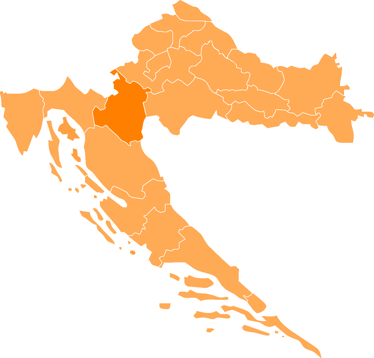
Croatia proper ( hr, Hrvatska) is one of the four historical regions of the Republic of Croatia, together with Dalmatia, Istria, and Slavonia. It is located between Slavonia in the east, the Adriatic Sea in the west, and Dalmatia to the south. The region is not officially defined, and its borders and extent are described differently by various sources. In contemporary geography, the terms Central Croatia () and Mountainous Croatia () are used to describe most of this area, the former referring to the northeastern part and the latter to the southwestern part; the far western part is known as the Croatian Littoral; likewise the terms 'Zagreb macroregion' and 'Rijeka macroregion' can be used instead. Croatia proper is the most significant economic area of the country, contributing well over 50% of Croatia's gross domestic product. The capital of the Republic of Croatia, Zagreb, is the largest city and most important economic centre in Croatia proper. Croatia proper comprises sev ... [...More Info...] [...Related Items...] OR: [Wikipedia] [Google] [Baidu] |
Regions Of Croatia
The Republic of Croatia is administratively organised into twenty counties, and is also traditionally divided into four historical and cultural regions: Croatia Proper, Dalmatia, Istria, and Slavonia. These are further divided into other, smaller regions. Historical regions Smaller regions * Banovina (or Banija) is a region in central Croatia, situated between the rivers Sava, Una and Kupa. * Baranja forms a small enclave between the region of Slavonia and the Republic of Hungary, it lies in the north east of Croatia. The rest of the region known as Baranja is located in Hungary. *Croatian Littoral (''Hrvatsko primorje'') the maritime region of Croatia proper * Gorski kotar the region occupies the area between the major cities of Karlovac and Rijeka (a.k.a. ''Fiume''). The regions main city is Delnice. The river Kupa separates the region from the Republic of Slovenia in the north. *Konavle forms a small subregion of Dalmatia in the very south of Croatia and stretches f ... [...More Info...] [...Related Items...] OR: [Wikipedia] [Google] [Baidu] |
Zagreb County
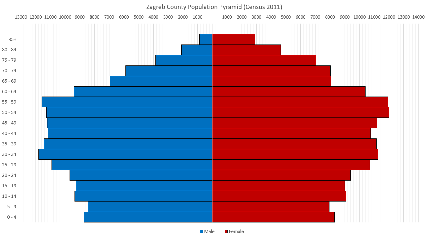
Zagreb County ( hr, Zagrebačka županija) is a county in Northern Croatia. It surrounds, but does not contain, the nation's capital Zagreb, which is a separate territorial unit. For that reason, the county is often nicknamed "Zagreb ring" ( hr, zagrebački prsten). According to the 2011 census, the county has 317,606 inhabitants, most of whom live in smaller urban satellite towns. The Zagreb County once included the city of Zagreb, but in 1997 they separated, when the City was given a special status. Although separated from the city of Zagreb both administratively and territorially, it remains closely linked with it. Zagreb County borders on Krapina-Zagorje County, the city of Zagreb, Varaždin County, and Koprivnica-Križevci County in the north, Bjelovar-Bilogora County in the east, Sisak-Moslavina County in the south and Karlovac County Karlovac County ( hr, Karlovačka županija) is a county in central Croatia, with the administrative center in Karlovac. The city ... [...More Info...] [...Related Items...] OR: [Wikipedia] [Google] [Baidu] |
Kordun
The Kordun () region is a part of central Croatia from the bottom of the Petrova Gora (Peter's mountain) mountain range, which extends along the rivers Korana and Slunjčica, and forms part of the border region to Bosnia and Herzegovina. Within Croatia, Kordun is bordered by the Lika region to the south and by Banovina or Banija to the east. Most of Kordun with its centre Slunj belongs to Karlovac County (Slunj, Cetingrad, Krnjak, Rakovica and Vojnić). Vrginmost belongs to Sisak-Moslavina County. In former times, this region belonged to the Habsburg Military Frontier towards the Ottoman Empire. Following the Croatian War of Independence, a number of towns and municipalities in the region were designated Areas of Special State Concern. The area has rich wood resources. Today, the economic situation is slowly improving, but there is still a large tendency of emigration from the region to larger cities. A typical phenomenon of this region is the porous composition of the ... [...More Info...] [...Related Items...] OR: [Wikipedia] [Google] [Baidu] |
Posavina
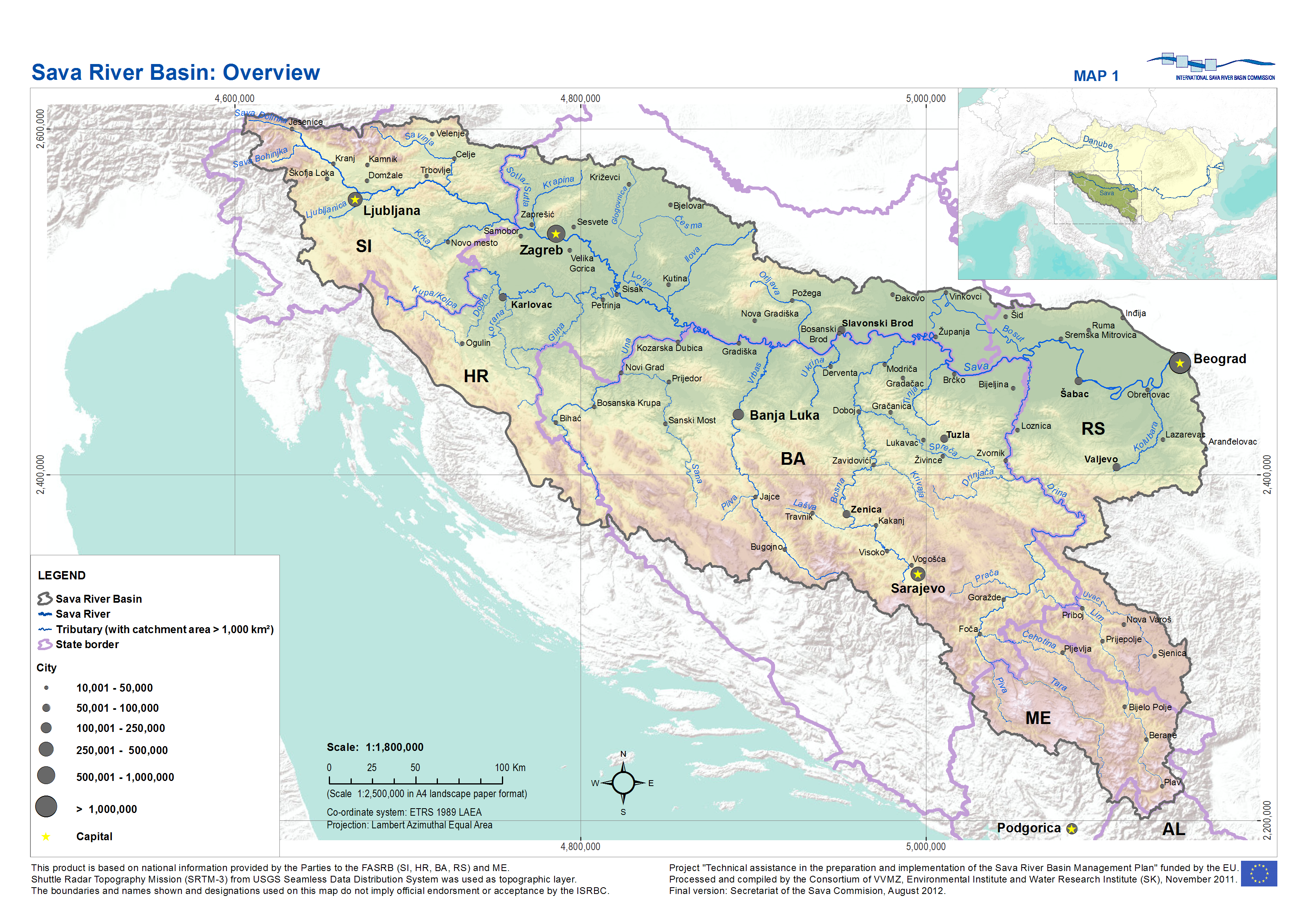
Posavina ( sr-cyr, Посавина) is a geographical region that stretches along the Sava river, encompassing only the inner areas of the Sava river basin, that are adjacent or near to the Sava river itself, namely catch region spanning from the Julian Alps in the northwest to the confluence with the Danube in the southeast. It passes through several countries of former Yugoslavia, namely Slovenia, Croatia, Bosnia and Herzegovina and Serbia. In Slovene, the term Posavina is not used to describe the parts of Slovenia that lie by the Sava river. Instead, the terms Posavje and Zasavje are used. Geography Geography of the Posavina region is defined by geological features of the central (inner) zones of the Sava river basin, that are near or adjacent to the Sava river itself. The region is stretched along the Sava river, that flows from west to east, connecting valleys and plains in transitional regions between the Dinaric Mountains and the Pannonian Plain. Geographical borders ... [...More Info...] [...Related Items...] OR: [Wikipedia] [Google] [Baidu] |
Podravina
''Podravina'' (in Croatian) or ''Podravje'' (in Slovenian) are Slavic names for the Drava river basin in Croatia and Slovenia. History Between 1929 and 1941 a province of the Kingdom of Yugoslavia known as the ''Drava Banovina'' (Drava province) existed in the area with its capital in Ljubljana. The ''Drava Banovina'' comprised most of present-day Slovenia. Today, one of the counties in Croatia is named Virovitica-Podravina, however the official capital of the region is the city of Koprivnica which is also the capital of Koprivnica-Križevci County. Major cities and towns along the river Cities and towns in Slovenia: *Dravograd *Maribor * Ptuj Cities and towns in Croatia: *Varaždin *Koprivnica (Capital of Croatian Podravina) * Đurđevac * Virovitica * Slatina *Osijek The state route D2 connects all Croatian towns in ''Podravina''. See also * Virovitica-Podravina County * Koprivnica-Križevci County * Varaždin County * Drava Banovina The Drava Banovina or Drava Banate ... [...More Info...] [...Related Items...] OR: [Wikipedia] [Google] [Baidu] |
Lika
Lika () is a traditional region of Croatia proper, roughly bound by the Velebit mountain from the southwest and the Plješevica mountain from the northeast. On the north-west end Lika is bounded by Ogulin-Plaški basin, and on the south-east by the Malovan pass. Today most of the territory of Lika (Brinje, Donji Lapac, Gospić, Lovinac, Otočac, Perušić, Plitvička Jezera, Udbina and Vrhovine) is part of Lika-Senj County. Josipdol, Plaški and Saborsko are part of Karlovac County and Gračac is part of Zadar County. Major towns include Gospić, Otočac, and Gračac, most of which are located in the karst poljes of the rivers of Lika, Gacka and others. The Plitvice Lakes National Park is also in Lika. History Antiquity Since the first millennium BC the region was inhabited by Iapydes, an ancient people related to Illyrians. During the Gallic invasion of the Balkans, a division of the Gallic army passed through the territory of today's Lika and a part of ... [...More Info...] [...Related Items...] OR: [Wikipedia] [Google] [Baidu] |
Gross Domestic Product
Gross domestic product (GDP) is a money, monetary Measurement in economics, measure of the market value of all the final goods and services produced and sold (not resold) in a specific time period by countries. Due to its complex and subjective nature this measure is often revised before being considered a reliable indicator. List of countries by GDP (nominal) per capita, GDP (nominal) per capita does not, however, reflect differences in the cost of living and the inflation, inflation rates of the countries; therefore, using a basis of List of countries by GDP (PPP) per capita, GDP per capita at purchasing power parity (PPP) may be more useful when comparing standard of living, living standards between nations, while nominal GDP is more useful comparing national economies on the international market. Total GDP can also be broken down into the contribution of each industry or sector of the economy. The ratio of GDP to the total population of the region is the GDP per capita, p ... [...More Info...] [...Related Items...] OR: [Wikipedia] [Google] [Baidu] |
Croatian Littoral
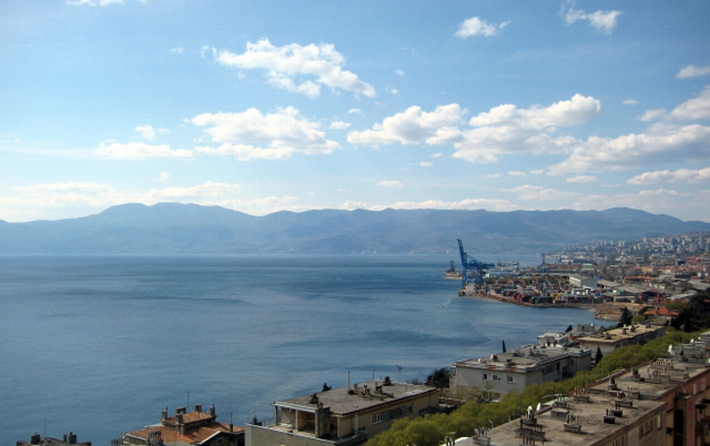
Croatian Littoral ( hr, Hrvatsko primorje) is a historical name for the region of Croatia comprising mostly the coastal areas between traditional Dalmatia to the south, Croatia proper, Mountainous Croatia to the north, Istria and the Kvarner Gulf of the Adriatic Sea to the west. The term "Croatian Littoral zone, Littoral" developed in the 18th and 19th centuries, reflecting the complex development of Croatia in historical and geographical terms. The region saw frequent changes to its ruling powers since classical antiquity, including the Roman Empire, the Ostrogoths, the Kingdom of the Lombards, Lombards, the Byzantine Empire, the Frankish Empire, and the Kingdom of Croatia (medieval), Croats, some of whose major historical heritage originates from the area—most notably the Baška tablet. The region and adjacent territories became a point of contention between major European powers, including the Republic of Venice, the Kingdom of Hungary, and the Habsburg monarchy, Habsburg a ... [...More Info...] [...Related Items...] OR: [Wikipedia] [Google] [Baidu] |
Adriatic Sea
The Adriatic Sea () is a body of water separating the Italian Peninsula from the Balkans, Balkan Peninsula. The Adriatic is the northernmost arm of the Mediterranean Sea, extending from the Strait of Otranto (where it connects to the Ionian Sea) to the northwest and the Po Valley. The countries with coasts on the Adriatic are Albania, Bosnia and Herzegovina, Croatia, Italy, Montenegro, and Slovenia. The Adriatic contains more than 1,300 islands, mostly located along the Croatian part of its eastern coast. It is divided into three basins, the northern being the shallowest and the southern being the deepest, with a maximum depth of . The Otranto Sill, an underwater ridge, is located at the border between the Adriatic and Ionian Seas. The prevailing currents flow counterclockwise from the Strait of Otranto, along the eastern coast and back to the strait along the western (Italian) coast. Tidal movements in the Adriatic are slight, although acqua alta, larger amplitudes are known to ... [...More Info...] [...Related Items...] OR: [Wikipedia] [Google] [Baidu] |
Slavonia
Slavonia (; hr, Slavonija) is, with Dalmatia, Croatia proper, and Istria, one of the four historical regions of Croatia. Taking up the east of the country, it roughly corresponds with five Croatian counties: Brod-Posavina, Osijek-Baranja, Požega-Slavonia, Virovitica-Podravina, and Vukovar-Syrmia, although the territory of the counties includes Baranya, and the definition of the western extent of Slavonia as a region varies. The counties cover or 22.2% of Croatia, inhabited by 806,192—18.8% of Croatia's population. The largest city in the region is Osijek, followed by Slavonski Brod and Vinkovci. Slavonia is located in the Pannonian Basin, largely bordered by the Danube, Drava, and Sava rivers. In the west, the region consists of the Sava and Drava valleys and the mountains surrounding the Požega Valley, and plains in the east. Slavonia enjoys a moderate continental climate with relatively low precipitation. After the fall of the Western Roman Empire, which ruled the ... [...More Info...] [...Related Items...] OR: [Wikipedia] [Google] [Baidu] |


