|
Moriyama, Nagasaki
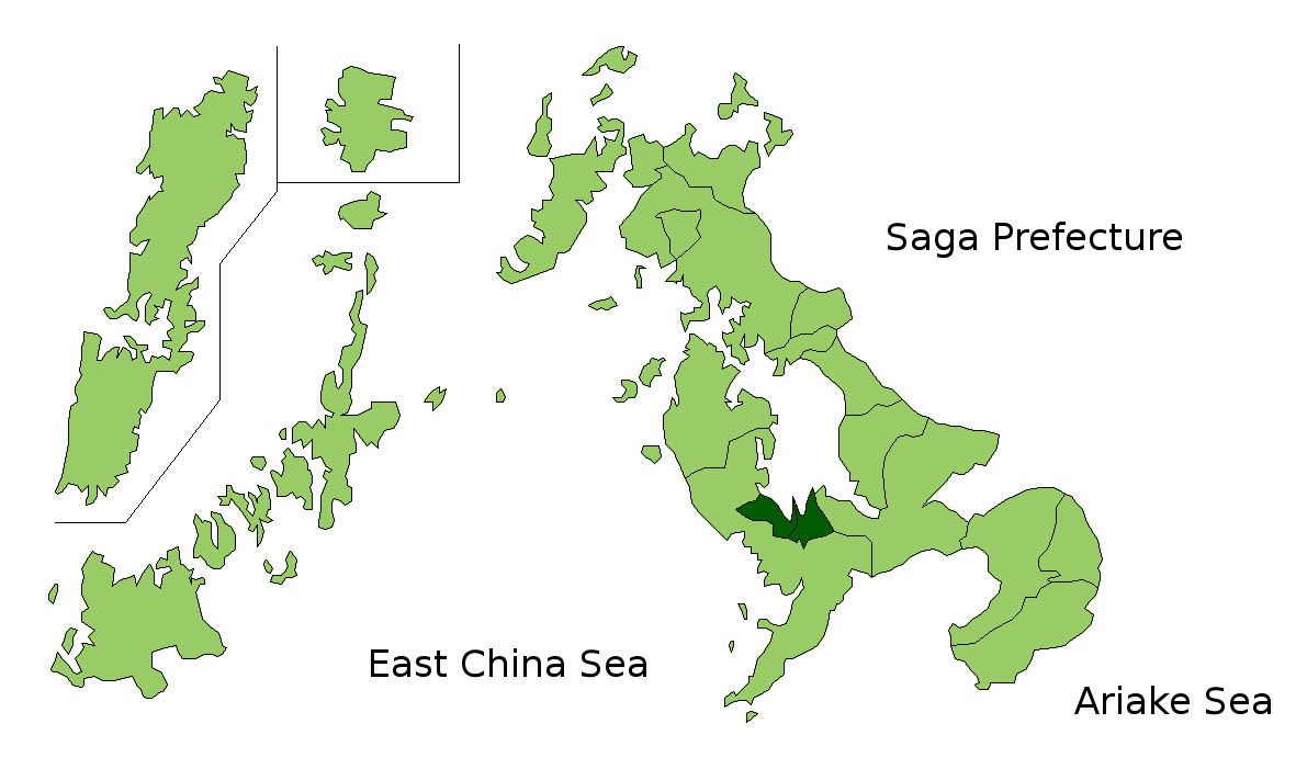
was a town located in Kitatakaki District, Nagasaki Prefecture, Japan. As of 2003, the town had an estimated population of 6,154 and a density of 264.57 persons per km2. The total area was 23.26 km2. On March 1, 2005, Moriyama, along with the town of Tarami (from Nishisonogi District), and the towns of Iimori, Konagai and Takaki (all from Kitatakaki District), was merged into the expanded city of Isahaya is a city located in Nagasaki Prefecture, Japan. The city was founded on September 1, 1940. As of November 1, 2022, the city has an estimated population of 132,385 and a population density of 389 persons per km². The total area is . On March 1 .... Dissolved municipalities of Nagasaki Prefecture {{Nagasaki-geo-stub ... [...More Info...] [...Related Items...] OR: [Wikipedia] [Google] [Baidu] |
List Of Towns In Japan
A town (町; ''chō'' or ''machi'') is a local administrative unit in Japan. It is a local public body along with prefecture (''ken'' or other equivalents), city (''shi''), and village (''mura''). Geographically, a town is contained within a district. Note that the same word (町; ''machi'' or ''chō'') is also used in names of smaller regions, usually a part of a ward in a city. This is a legacy of when smaller towns were formed on the outskirts of a city, only to eventually merge into it. Towns See also * Municipalities of Japan * Japanese addressing system The Japanese addressing system is used to identify a specific location in Japan. When written in Japanese characters, addresses start with the largest geographical entity and proceed to the most specific one. When written in Latin characters, ad ... References {{reflist External links "Large_City_System_of_Japan";_graphic_shows_towns_compared_with_other_Japanese_city_types_at_p._1_[PDF_7_of_40/nowiki>">DF_7_of_4 ... [...More Info...] [...Related Items...] OR: [Wikipedia] [Google] [Baidu] |
Kitatakaki District, Nagasaki
was a district located in Nagasaki Prefecture, Japan. As of 2003, the district had an estimated population of 31,482 and a density of 244.41 persons per km2. The total area was 128.81 km2. Towns and villages * Iimori * Konagai * Moriyama * Takaki Merger On January 4, 2005, the towns of Iimori, Konagai, Moriyama and Takaki were merged into the expanded city of Isahaya is a city located in Nagasaki Prefecture, Japan. The city was founded on September 1, 1940. As of November 1, 2022, the city has an estimated population of 132,385 and a population density of 389 persons per km². The total area is . On March 1 .... Kitatakaki District was dissolved as a result of this merger. References {{coord missing, Nagasaki Prefecture Former districts of Nagasaki Prefecture ... [...More Info...] [...Related Items...] OR: [Wikipedia] [Google] [Baidu] |
Nagasaki Prefecture
is a Prefectures of Japan, prefecture of Japan located on the island of Kyūshū. Nagasaki Prefecture has a population of 1,314,078 (1 June 2020) and has a geographic area of 4,130 Square kilometre, km2 (1,594 sq mi). Nagasaki Prefecture borders Saga Prefecture to the northeast. Nagasaki is the capital and largest city of Nagasaki Prefecture, with other major cities including Sasebo, Nagasaki, Sasebo, Isahaya, Nagasaki, Isahaya, and Ōmura, Nagasaki, Ōmura. Nagasaki Prefecture is located in western Kyūshū with a territory consisting of many mainland peninsulas centered around Ōmura Bay, as well as islands and archipelagos including Tsushima Island, Tsushima and Iki Island, Iki in the Korea Strait and the Gotō Islands in the East China Sea. Nagasaki Prefecture is known for its century-long Nanban trade, trading history with the Europeans and as the sole place of direct trade and exchange between Japan and the outside world during the ''Sakoku'' period. Nagasaki Prefecture is h ... [...More Info...] [...Related Items...] OR: [Wikipedia] [Google] [Baidu] |
Japan
Japan ( ja, 日本, or , and formally , ''Nihonkoku'') is an island country in East Asia. It is situated in the northwest Pacific Ocean, and is bordered on the west by the Sea of Japan, while extending from the Sea of Okhotsk in the north toward the East China Sea, Philippine Sea, and Taiwan in the south. Japan is a part of the Ring of Fire, and spans Japanese archipelago, an archipelago of List of islands of Japan, 6852 islands covering ; the five main islands are Hokkaido, Honshu (the "mainland"), Shikoku, Kyushu, and Okinawa Island, Okinawa. Tokyo is the Capital of Japan, nation's capital and largest city, followed by Yokohama, Osaka, Nagoya, Sapporo, Fukuoka, Kobe, and Kyoto. Japan is the List of countries and dependencies by population, eleventh most populous country in the world, as well as one of the List of countries and dependencies by population density, most densely populated and Urbanization by country, urbanized. About three-fourths of Geography of Japan, the c ... [...More Info...] [...Related Items...] OR: [Wikipedia] [Google] [Baidu] |
Population
Population typically refers to the number of people in a single area, whether it be a city or town, region, country, continent, or the world. Governments typically quantify the size of the resident population within their jurisdiction using a census, a process of collecting, analysing, compiling, and publishing data regarding a population. Perspectives of various disciplines Social sciences In sociology and population geography, population refers to a group of human beings with some predefined criterion in common, such as location, race, ethnicity, nationality, or religion. Demography is a social science which entails the statistical study of populations. Ecology In ecology, a population is a group of organisms of the same species who inhabit the same particular geographical area and are capable of interbreeding. The area of a sexual population is the area where inter-breeding is possible between any pair within the area and more probable than cross-breeding with in ... [...More Info...] [...Related Items...] OR: [Wikipedia] [Google] [Baidu] |
Population Density
Population density (in agriculture: standing stock or plant density) is a measurement of population per unit land area. It is mostly applied to humans, but sometimes to other living organisms too. It is a key geographical term.Matt RosenberPopulation Density Geography.about.com. March 2, 2011. Retrieved on December 10, 2011. In simple terms, population density refers to the number of people living in an area per square kilometre, or other unit of land area. Biological population densities Population density is population divided by total land area, sometimes including seas and oceans, as appropriate. Low densities may cause an extinction vortex and further reduce fertility. This is called the Allee effect after the scientist who identified it. Examples of the causes of reduced fertility in low population densities are * Increased problems with locating sexual mates * Increased inbreeding Human densities Population density is the number of people per unit of area, usuall ... [...More Info...] [...Related Items...] OR: [Wikipedia] [Google] [Baidu] |
Tarami, Nagasaki
was a town located in Nishisonogi District, Nagasaki Prefecture, Japan. As of 2003, the town had an estimated population of 16,995 and a density of 448.65 persons per km2. The total area was 37.88 km2. On March 1, 2005, Tarami, along with the towns of Iimori, Konagai, Moriyama and Takaki (all from Kitatakaki District), was merged into the expanded city of Isahaya is a city located in Nagasaki Prefecture, Japan. The city was founded on September 1, 1940. As of November 1, 2022, the city has an estimated population of 132,385 and a population density of 389 persons per km². The total area is . On March 1 .... Dissolved municipalities of Nagasaki Prefecture {{Nagasaki-geo-stub ... [...More Info...] [...Related Items...] OR: [Wikipedia] [Google] [Baidu] |
Nishisonogi District, Nagasaki
is a district located in Nagasaki Prefecture, Japan. As of January 1, 2009, the district has an estimated population of 72,238 and a density of 1460 persons per km2. The total area is 49.54 km2. Towns and villages *Nagayo *Togitsu Mergers * January 1, 1955 the village of Fukuda merged into the city of Nagasaki. *On January 4, 2005 six towns, Iōjima, Kōyagi, Nomozaki, Sanwa, Sotome and Takashima merged into the city of Nagasaki. *On March 1, 2005 the town of Tarami, along with the towns of Iimori, Konagai, Moriyama and Takaki, all from Kitatakaki District, merged into the expanded city of Isahaya. *On April 1, 2005 the old town of Saikai absorbed the towns of Ōseto, Ōshima, Sakito and Seihi to form the new city of Saikai. *On January 4, 2006 the town of Kinkai merged into the city of Nagasaki is the capital and the largest city of Nagasaki Prefecture on the island of Kyushu in Japan. It became the sole port used for trade with the Portugu ... [...More Info...] [...Related Items...] OR: [Wikipedia] [Google] [Baidu] |
Iimori, Nagasaki
was a town located in Kitatakaki District, Nagasaki Prefecture, Japan. As of 2003, the town had an estimated population of 7,979 and a density of 321.35 persons per km2. The total area was 24.83 km2. On March 1, 2005, Iimori, along with the town of Tarami (from Nishisonogi District), and the towns of Konagai, Moriyama and Takaki (all from Kitatakaki District), was merged into the expanded city of Isahaya is a city located in Nagasaki Prefecture, Japan. The city was founded on September 1, 1940. As of November 1, 2022, the city has an estimated population of 132,385 and a population density of 389 persons per km². The total area is . On March 1 .... References Dissolved municipalities of Nagasaki Prefecture {{Nagasaki-geo-stub ... [...More Info...] [...Related Items...] OR: [Wikipedia] [Google] [Baidu] |
Konagai, Nagasaki
was a town located in Kitatakaki District, Nagasaki Prefecture, Japan. As of 2003, the town had an estimated population of 6,437 and a density of 208.12 persons per km2. The total area was 30.93 km2. On March 1, 2005, Konagai, along with the town of Tarami (from Nishisonogi District), and the towns of Iimori, Moriyama and Takaki (all from Kitatakaki District), was merged into the expanded city of Isahaya is a city located in Nagasaki Prefecture, Japan. The city was founded on September 1, 1940. As of November 1, 2022, the city has an estimated population of 132,385 and a population density of 389 persons per km². The total area is . On March 1 .... Dissolved municipalities of Nagasaki Prefecture {{Nagasaki-geo-stub ... [...More Info...] [...Related Items...] OR: [Wikipedia] [Google] [Baidu] |
Takaki, Nagasaki
was a town located in Kitatakaki District, Nagasaki Prefecture, Japan. As of 2003, the town had an estimated population of 10,912 and a density of 219.16 persons per km2. The total area was 49.79 km2. On March 1, 2005, Takaki, along with the town of Tarami (from Nishisonogi District), and the towns of Iimori, Konagai and Moriyama (all from Kitatakaki District), was merged into the expanded city of Isahaya is a city located in Nagasaki Prefecture, Japan. The city was founded on September 1, 1940. As of November 1, 2022, the city has an estimated population of 132,385 and a population density of 389 persons per km². The total area is . On March 1 .... Dissolved municipalities of Nagasaki Prefecture {{Nagasaki-geo-stub ... [...More Info...] [...Related Items...] OR: [Wikipedia] [Google] [Baidu] |
Isahaya, Nagasaki
is a Cities of Japan, city located in Nagasaki Prefecture, Japan. The city was founded on September 1, 1940. As of November 1, 2022, the city has an estimated population of 132,385 and a population density of 389 persons per km². The total area is . On March 1, 2005, the towns of Tarami, Nagasaki, Tarami, Moriyama, Nagasaki, Moriyama, Iimori, Nagasaki, Iimori, Takaki, Nagasaki, Takaki and Konagai, Nagasaki, Konagai (all from Kitatakaki District, Nagasaki, Kitatakaki District) were merged to create the new and expanded city of Isahaya. The city was once part of Kitatakaki District, but due to this merger, the district has no more municipalities left and the district was officially dissolved. History In July 1957, a severe downpour within Nagasaki caused a large flood in Isahaya, with over 500 casualties and 3500 injuries reported in Isahaya alone. Geography Located in the central part of Nagasaki Prefecture. To the north of Isahaya City are mountainous lands of the Takayam ... [...More Info...] [...Related Items...] OR: [Wikipedia] [Google] [Baidu] |


