|
Moose Creek (Yukon)
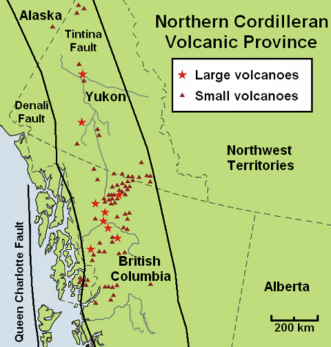
Moose Creek is a creek in western Yukon, Canada. The landscape surrounding Moose Creek lies in the Northern Cordilleran Volcanic Province. During the Cenozoic era, volcanic activity engulfed the Moose Creek area. However, the type of volcanic landform these volcanics represent is unknown. See also *List of rivers of Yukon *List of volcanoes in Canada *List of Northern Cordilleran volcanoes *Volcanism of Canada *Volcanism of Northern Canada Volcanism of Northern Canada has produced hundreds of volcanic areas and extensive lava formations across Northern Canada. The region's different volcano and lava types originate from different tectonic settings and types of volcanic eruptions, ra ... References Rivers of Yukon Volcanism of Yukon Cenozoic volcanism {{Yukon-river-stub ... [...More Info...] [...Related Items...] OR: [Wikipedia] [Google] [Baidu] |
Yukon
Yukon (; ; formerly called Yukon Territory and also referred to as the Yukon) is the smallest and westernmost of Canada's three territories. It also is the second-least populated province or territory in Canada, with a population of 43,964 as of March 2022. Whitehorse, the territorial capital, is the largest settlement in any of the three territories. Yukon was split from the North-West Territories in 1898 as the Yukon Territory. The federal government's ''Yukon Act'', which received royal assent on March 27, 2002, established Yukon as the territory's official name, though ''Yukon Territory'' is also still popular in usage and Canada Post continues to use the territory's internationally approved postal abbreviation of ''YT''. In 2021, territorial government policy was changed so that “''The'' Yukon” would be recommended for use in official territorial government materials. Though officially bilingual (English and French), the Yukon government also recognizes First Natio ... [...More Info...] [...Related Items...] OR: [Wikipedia] [Google] [Baidu] |
Northern Cordilleran Volcanic Province
The Northern Cordilleran Volcanic Province (NCVP), formerly known as the Stikine Volcanic Belt, is a geologic province defined by the occurrence of Miocene to Holocene volcanoes in the Pacific Northwest of North America. This belt of volcanoes extends roughly north-northwest from northwestern British Columbia and the Alaska Panhandle through Yukon to the Southeast Fairbanks Census Area of far eastern Alaska, in a corridor hundreds of kilometres wide. It is the most recently defined volcanic province in the Western Cordillera. It has formed due to extensional cracking of the North American continent—similar to other on-land extensional volcanic zones, including the Basin and Range Province and the East African Rift. Although taking its name from the Western Cordillera, this term is a geologic grouping rather than a geographic one. The southmost part of the NCVP has more, and larger, volcanoes than does the rest of the NCVP; further north it is less clearly delineated, describin ... [...More Info...] [...Related Items...] OR: [Wikipedia] [Google] [Baidu] |
Cenozoic
The Cenozoic ( ; ) is Earth's current geological era, representing the last 66million years of Earth's history. It is characterised by the dominance of mammals, birds and flowering plants, a cooling and drying climate, and the current configuration of continents. It is the latest of three geological eras since complex life evolved, preceded by the Mesozoic and Paleozoic. It started with the Cretaceous–Paleogene extinction event, when many species, including the non-avian dinosaurs, became extinct in an event attributed by most experts to the impact of a large asteroid or other celestial body, the Chicxulub impactor. The Cenozoic is also known as the Age of Mammals because the terrestrial animals that dominated both hemispheres were mammalsthe eutherians (placentals) in the northern hemisphere and the metatherians (marsupials, now mainly restricted to Australia) in the southern hemisphere. The extinction of many groups allowed mammals and birds to greatly diversify so that l ... [...More Info...] [...Related Items...] OR: [Wikipedia] [Google] [Baidu] |
List Of Rivers Of Yukon
This is a list of rivers of Yukon. Arctic Ocean watershed * Mackenzie River watershed **Upper Liard River *** Rancheria River ****Little Rancheria River ***Frances River ***Hyland River *** Coal River *** La Biche River *** Beaver River (Liard River tributary) **** Whitefish River *** Kotaneelee River *** Smith River ***South Nahanni River ** Peel River *** Ogilvie River ***Blackstone River ***Hart River *** Wind River *** Bonnet Plume River ***Snake River *Firth River *Malcolm River *Trail River *Babbage River *Blow River * Clarence River Bering Sea watershed *Yukon River **Marsh Lake ***McClintock Creek ***Tagish River ****Tagish Lake ***** Bennett Lake *****Atlin Lake ***** Nares River ****** Little Atlin Lake ****** Partridge River **Teslin River ***Teslin Lake **** Nisutlin River ***** Wolf Rover *** Dän Tàgé *** Morley River **Takhini River ***Kusawa Lake *** Swift River ** Big Salmon River ***Quiet Lake ** Nordenskiold River ** Pelly River ***Hoole River *** Ross River ... [...More Info...] [...Related Items...] OR: [Wikipedia] [Google] [Baidu] |
List Of Volcanoes In Canada
List of volcanoes in Canada is an incomplete list of volcanoes found in Mainland Canada, in the Canadian islands and in Canadian waters. All but one province, Prince Edward Island, have at least one volcano. Alberta British Columbia New Brunswick Newfoundland and Labrador Northwest Territories Nova Scotia Nunavut Ontario Quebec Saskatchewan Yukon See also * Outline of Canada * Bibliography of Canada * Index of Canada-related articles * Volcanism of Canada ** Volcanism of Northern Canada ** Volcanism of Western Canada ** Volcanism of Eastern Canada ** List of Northern Cordilleran volcanoes * List of mountains in Canada * List of Cascade volcanoes External links Catalogue of Canadian Volcanoes {{Canadian volcanism Canada Volcanoes Volcanoes Volcanoes A volcano is a rupture in the crust of a planetary-mass object, such as Earth, that allows hot lava, volcanic ash, and gases to escape from a magma chamber below the surface. On Earth, ... [...More Info...] [...Related Items...] OR: [Wikipedia] [Google] [Baidu] |
List Of Northern Cordilleran Volcanoes
The geography of northwestern British Columbia and Yukon, Canada is dominated by volcanoes of the Northern Cordilleran Volcanic Province formed due to continental rifting of the North American Plate. It is the most active volcanic region in Canada. Some of the volcanoes are notable for their eruptions, for instance, Tseax Cone for its catastrophic eruption estimated to have occurred in the 18th century which was responsible for the death of at least 2,000 Nisga'a people from poisonous volcanic gases, the Mount Edziza volcanic complex for at least 20 eruptions throughout the past 10,000 years, and The Volcano (also known as Lava Fork volcano) for the most recent eruption in Canada during 1904. The majority of volcanoes in the Northern Cordilleran Volcanic Province lie in Canada while a very small portion of the volcanic province lies in the U.S. state of Alaska. Volcanoes of the Northern Cordilleran Volcanic Province are a part of the Pacific Ring of Fire. The largest a ... [...More Info...] [...Related Items...] OR: [Wikipedia] [Google] [Baidu] |
Volcanism Of Canada
Volcanic activity is a major part of the geology of Canada and is characterized by many types of volcanic landform, including lava flows, volcanic plateaus, lava domes, cinder cones, stratovolcanoes, shield volcanoes, submarine volcanoes, calderas, diatremes, and maars, along with less common volcanic forms such as tuyas and subglacial mounds. Though Canada's volcanic history dates back to the Precambrian eon, at least 3.11 billion years ago, when its part of the North American continent began to form, volcanism continues to occur in Western and Northern Canada in modern times, where it forms part of an encircling chain of volcanoes and frequent earthquakes around the Pacific Ocean called the Pacific Ring of Fire. Because volcanoes in Western and Northern Canada are in relatively remote and sparsely populated areas and their activity is less frequent than with other volcanoes around the Pacific Ocean, Canada is commonly thought to occupy a gap in the Ring of Fire between the ... [...More Info...] [...Related Items...] OR: [Wikipedia] [Google] [Baidu] |
Volcanism Of Northern Canada
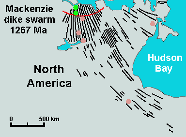
Volcanism of Northern Canada has produced hundreds of volcanic areas and extensive lava formations across Northern Canada. The region's different volcano and lava types originate from different tectonic settings and types of volcanic eruptions, ranging from passive lava eruptions to violent explosive eruptions. Northern Canada has a record of very large volumes of magmatic rock called large igneous provinces. They are represented by deep-level plumbing systems consisting of giant dike swarms, sill provinces and layered intrusions. Plume and rift complexes Vast volumes of basaltic lava covered Northern Canada in the form of a flood basalt event 1,267 million years ago that engulfed the landscape near the Coppermine River southwest of Coronation Gulf in the Canadian Arctic. This volcanic activity built an extensive lava plateau and large igneous province with an area of representing a volume of lavas of at least . With an area of and a volume of , it is larger than the Col ... [...More Info...] [...Related Items...] OR: [Wikipedia] [Google] [Baidu] |
Rivers Of Yukon
A river is a natural flowing watercourse, usually freshwater, flowing towards an ocean, sea, lake or another river. In some cases, a river flows into the ground and becomes dry at the end of its course without reaching another body of water. Small rivers can be referred to using names such as creek, brook, rivulet, and rill. There are no official definitions for the generic term river as applied to geographic features, although in some countries or communities a stream is defined by its size. Many names for small rivers are specific to geographic location; examples are "run" in some parts of the United States, "burn" in Scotland and northeast England, and "beck" in northern England. Sometimes a river is defined as being larger than a creek, but not always: the language is vague. Rivers are part of the water cycle. Water generally collects in a river from precipitation through a drainage basin from surface runoff and other sources such as groundwater recharge, springs, a ... [...More Info...] [...Related Items...] OR: [Wikipedia] [Google] [Baidu] |
Volcanism Of Yukon
Volcanism, vulcanism or volcanicity is the phenomenon of eruption of molten rock (magma) onto the surface of the Earth or a solid-surface planet or moon, where lava, pyroclastics, and volcanic gases erupt through a break in the surface called a vent. It includes all phenomena resulting from and causing magma within the crust or mantle of the body, to rise through the crust and form volcanic rocks on the surface. Magmas, that reach the surface and solidify, form extrusive landforms. Volcanic processes Magma from the mantle or lower crust rises through the crust towards the surface. If magma reaches the surface, its behavior depends on the viscosity of the molten constituent rock. Viscous (thick) magma produces volcanoes characterised by explosive eruptions, while non-viscous (runny) magma produce volcanoes characterised by effusive eruptions pouring large amounts of lava onto the surface. In some cases, rising magma can cool and solidify without reaching the surface. Instead, ... [...More Info...] [...Related Items...] OR: [Wikipedia] [Google] [Baidu] |


