|
Mokhovoye, Kaliningrad Oblast
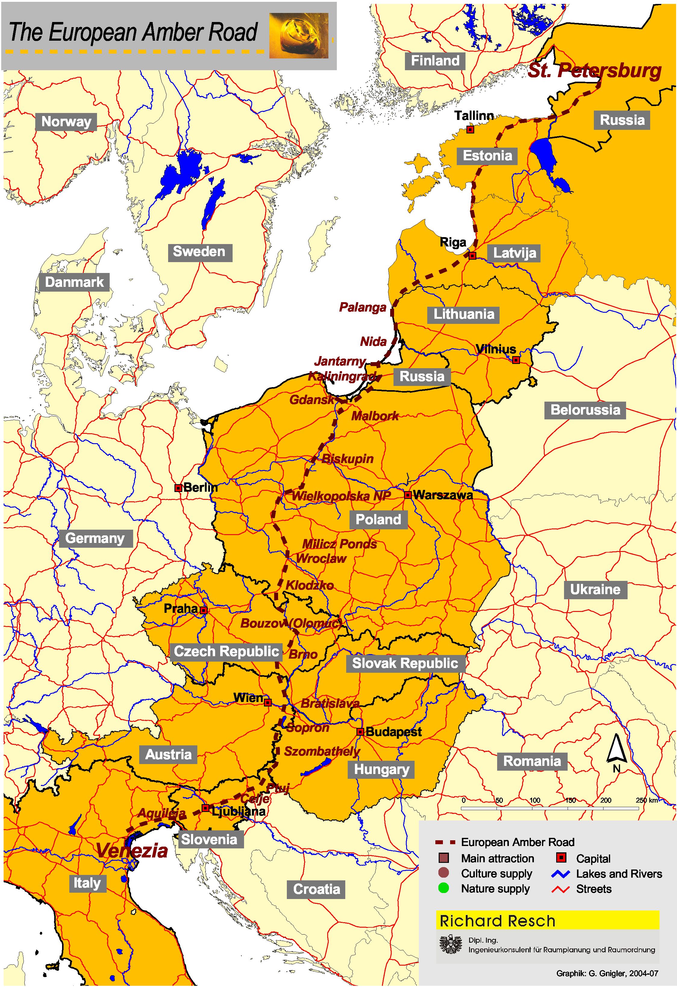
Mokhovoye (russian: Мохово́е; german: Wiskiauten; lt, Viskiautai) is a rural locality (a settlement) in Zelenogradsky District of Kaliningrad Oblast, Russia, less than 4 km from Zelenogradsk and from the southwestern corner of the Curonian Lagoon. About 320 people live there. Kaup is the name of a hill immediately north, where a large burial site with Scandinavian grave goods was found. It was important in early medieval history as a likely starting point of the Amber Road The Amber Road was an ancient trade route for the transfer of amber from coastal areas of the North Sea and the Baltic Sea to the Mediterranean Sea. Prehistoric trade routes between Northern and Southern Europe were defined by the amber trade. ... to the south. External links Annual Viking festival in Mokhovoye {{Authority control Rural localities in Kaliningrad Oblast Zelenogradsky District ... [...More Info...] [...Related Items...] OR: [Wikipedia] [Google] [Baidu] |
Types Of Inhabited Localities In Russia
The classification system of inhabited localities in Russia and some other post-Soviet states has certain peculiarities compared with those in other countries. Classes During the Soviet time, each of the republics of the Soviet Union, including the Russian SFSR, had its own legislative documents dealing with classification of inhabited localities. After the dissolution of the Soviet Union, the task of developing and maintaining such classification in Russia was delegated to the federal subjects.Articles 71 and 72 of the Constitution of Russia do not name issues of the administrative and territorial structure among the tasks handled on the federal level or jointly with the governments of the federal subjects. As such, all federal subjects pass their own laws establishing the system of the administrative-territorial divisions on their territories. While currently there are certain peculiarities to classifications used in many federal subjects, they are all still largely ba ... [...More Info...] [...Related Items...] OR: [Wikipedia] [Google] [Baidu] |
Zelenogradsky District
Zelenogradsky District (russian: Зеленогра́дский райо́н) is an administrative district (raion), one of the fifteen in Kaliningrad Oblast, Russia. It is located in the west of the oblast. The area of the district is . Its administrative center is the town of Zelenogradsk.Resolution #639 Population: 32,504 ( 2002 Census); The population of Zelenogradsk accounts for 40.4% of the district's total population. Administrative and municipal status Within the framework of administrative divisions, Zelenogradsky District is one of the fifteen in the oblast.Law #463 The town of Zelenogradsk serves as its administrative center. As a municipal division, the district has been incorporated as Zelenogradsky Urban Okrug since May 15, 2015.Law #420 Prior to that date, the district was incorporated as Zelenogradsky Municipal District, which was subdivided into one urban settlement and four rural settlements.Law #501 In 2022, Zelenogradsky was changed from an administr ... [...More Info...] [...Related Items...] OR: [Wikipedia] [Google] [Baidu] |
Kaliningrad Oblast
Kaliningrad Oblast (russian: Калинингра́дская о́бласть, translit=Kaliningradskaya oblast') is the westernmost federal subject of Russia. It is a semi-exclave situated on the Baltic Sea. The largest city and administrative centre of the province (oblast) is the city of Kaliningrad, formerly known as Königsberg. The port city of Baltiysk is Russia's only port on the Baltic Sea that remains ice-free in winter. Kaliningrad Oblast had a population of roughly 1 million in the Russian Census of 2010. The oblast is bordered by Poland to the south, Lithuania to the north and east and the Baltic Sea to the north-west. The territory was formerly the northern part of the Prussian province of East Prussia; the remaining southern part of the province is today part of the Warmian-Masurian Voivodeship in Poland. With the defeat of Nazi Germany in World War II, the territory was annexed to the Russian SFSR by the Soviet Union. Following the post-war migrat ... [...More Info...] [...Related Items...] OR: [Wikipedia] [Google] [Baidu] |
Russia
Russia (, , ), or the Russian Federation, is a List of transcontinental countries, transcontinental country spanning Eastern Europe and North Asia, Northern Asia. It is the List of countries and dependencies by area, largest country in the world, with its internationally recognised territory covering , and encompassing one-eighth of Earth's inhabitable landmass. Russia extends across Time in Russia, eleven time zones and shares Borders of Russia, land boundaries with fourteen countries, more than List of countries and territories by land borders, any other country but China. It is the List of countries and dependencies by population, world's ninth-most populous country and List of European countries by population, Europe's most populous country, with a population of 146 million people. The country's capital and List of cities and towns in Russia by population, largest city is Moscow, the List of European cities by population within city limits, largest city entirely within E ... [...More Info...] [...Related Items...] OR: [Wikipedia] [Google] [Baidu] |
Zelenogradsk
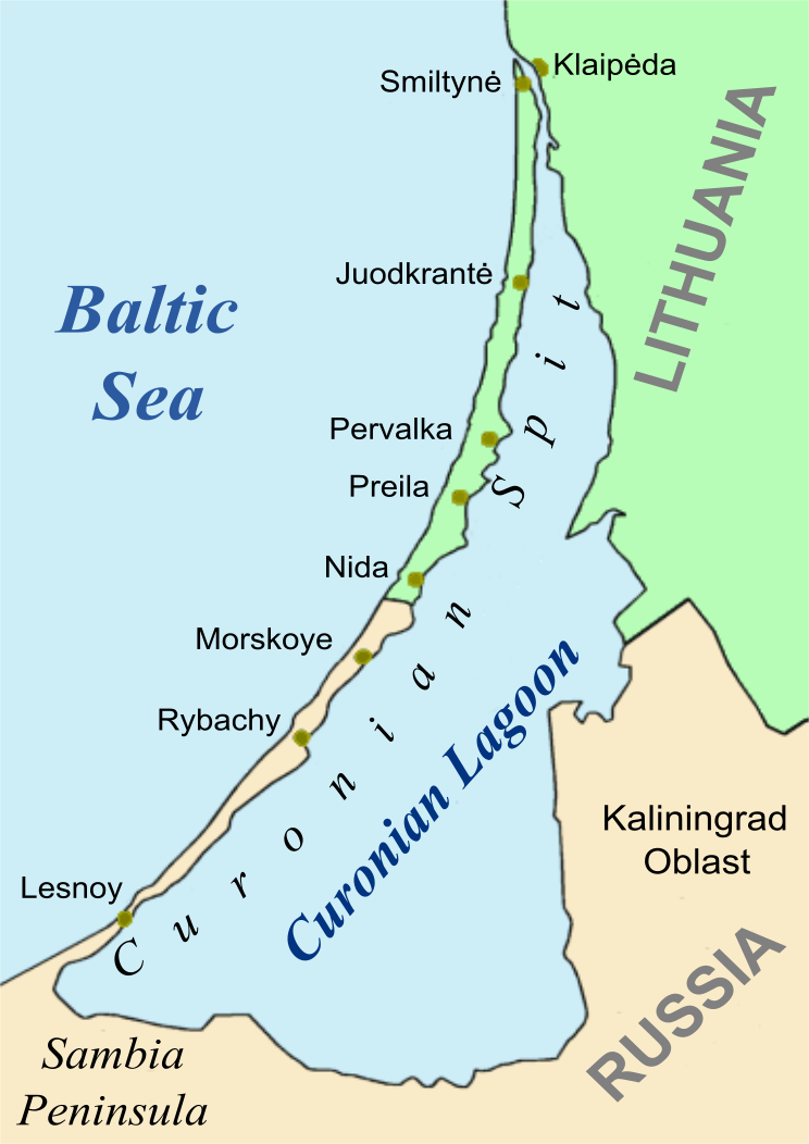
Zelenogradsk (; german: Cranz; pl, Koronowo; Lithuanian and Old Prussian: ''Krantas'') is a town and the administrative center of Zelenogradsky District in Kaliningrad Oblast, Russia, located north of Kaliningrad, on the Sambian coastline near the Curonian Spit on the Baltic Sea. Population: In its heyday, Zelenogradsk (as ''Cranz'') was a popular seaside resort on Germany's eastern Baltic coast, comparable to Bognor Regis in England. However, at the end of World War II, the Soviets took over the town, and much of its tourist traffic has been diverted to nearby Svetlogorsk. History The site of today's Zelenogradsk was originally an Old Prussian fishing village, in the proximity of Kaup, a Prussian town on the coast of the Baltic Sea in the Viking era. The area became controlled by the Teutonic Order and settled with Germans. The German name ''Cranz'', originally ''Cranzkuhren'', derives from the Old Prussian word ''krantas'', meaning "the coast". In 1454, King Casimir IV Ja ... [...More Info...] [...Related Items...] OR: [Wikipedia] [Google] [Baidu] |
Curonian Lagoon
The Curonian Lagoon (or Bay, Gulf; russian: Куршский залив, lt, Kuršių marios, pl, Zalew Kuroński, german: Kurisches Haff, lv, Kuršu joma) is a freshwater lagoon separated from the Baltic Sea by the Curonian Spit. Its surface area is . The Neman River ( lt, Nemunas) supplies about 90% of its inflows; its watershed consists of about 100,450 square kilometres in Lithuania and Russia's Kaliningrad Oblast. Human history In the 13th century, the area around the lagoon was part of the ancestral lands of the Curonians and Old Prussians. Later it bordered the historical region of Lithuania Minor. At the northern end of the Spit, the Klaipėda Strait connects the lagoon to the Baltic Sea, and the place was chosen by the Teutonic Knights in 1252 to found ''Memelburg'' castle and the city of Memel — officially called Klaipėda in 1923–39, when the Memel Territory was separated from Germany, and again after 1945, when it became part of the Lithuanian SSR. As the ... [...More Info...] [...Related Items...] OR: [Wikipedia] [Google] [Baidu] |
Kaup (hill)
Kaup is a hill on the bank of the Curonian Lagoon, immediately north of the village of Mokhovoye, Kaliningrad Oblast, Russia. It is a large early medieval burial site with Norse grave goods. Kaup has been viewed by historians as an important early medieval emporium and a likely starting point of the Amber Road to the south. The original name of this medieval settlement is uncertain. History Archaeological excavations, undertaken in 1899 and 1932, when the area was a part of East Prussia, and in 1979, during Soviet times, suggest that a major center of Old Prussians sprang up there in the early 9th century. Kaup may have been its name, because the place-name is cognate to Old Prussian (and Germanic) terms for "purchase". Marija Gimbutas describes it as the gateway for the traffic leading to the east via the lower Nemunas basin into the lands of the Curonians, Lithuanians, and other Baltic tribes.M. Gimbutas. ''The Balts.'' London: Thames and Hudson, 1963.Following the decline of ... [...More Info...] [...Related Items...] OR: [Wikipedia] [Google] [Baidu] |
Scandinavia
Scandinavia; Sámi languages: /. ( ) is a subregion#Europe, subregion in Northern Europe, with strong historical, cultural, and linguistic ties between its constituent peoples. In English usage, ''Scandinavia'' most commonly refers to Denmark, Norway, and Sweden. It can sometimes also refer more narrowly to the Scandinavian Peninsula (which excludes Denmark but includes part of Finland), or more broadly to include all of Finland, Iceland, and the Faroe Islands. The geography of the region is varied, from the Norwegian fjords in the west and Scandinavian mountains covering parts of Norway and Sweden, to the low and flat areas of Denmark in the south, as well as archipelagos and lakes in the east. Most of the population in the region live in the more temperate southern regions, with the northern parts having long, cold, winters. The region became notable during the Viking Age, when Scandinavian peoples participated in large scale raiding, conquest, colonization and trading mostl ... [...More Info...] [...Related Items...] OR: [Wikipedia] [Google] [Baidu] |
Grave Goods
Grave goods, in archaeology and anthropology, are the items buried along with the body. They are usually personal possessions, supplies to smooth the deceased's journey into the afterlife or offerings to the gods. Grave goods may be classed as a type of votive deposit. Most grave goods recovered by archaeologists consist of inorganic objects such as pottery and stone and metal tools but organic objects that have since decayed were also placed in ancient tombs. The grave goods were to be useful to the deceased in the afterlife; therefore their favorite foods or everyday objects were left with them. Often times social status played a role in what was left and how often it was left. Funerary art is a broad term but generally means artworks made specifically to decorate a burial place, such as miniature models of possessions including slaves or servants for "use" in the afterlife. Although, in ancient Egypt they would sometimes bury the real servants with the deceased. Where grave go ... [...More Info...] [...Related Items...] OR: [Wikipedia] [Google] [Baidu] |
Early Middle Ages
The Early Middle Ages (or early medieval period), sometimes controversially referred to as the Dark Ages, is typically regarded by historians as lasting from the late 5th or early 6th century to the 10th century. They marked the start of the Middle Ages of European history, following the decline of the Western Roman Empire, and preceding the High Middle Ages ( 11th to 13th centuries). The alternative term ''late antiquity'', for the early part of the period, emphasizes elements of continuity with the Roman Empire, while ''Early Middle Ages'' is used to emphasize developments characteristic of the earlier medieval period. The period saw a continuation of trends evident since late classical antiquity, including population decline, especially in urban centres, a decline of trade, a small rise in average temperatures in the North Atlantic region and increased migration. In the 19th century the Early Middle Ages were often labelled the ''Dark Ages'', a characterization based on t ... [...More Info...] [...Related Items...] OR: [Wikipedia] [Google] [Baidu] |
Amber Road
The Amber Road was an ancient trade route for the transfer of amber from coastal areas of the North Sea and the Baltic Sea to the Mediterranean Sea. Prehistoric trade routes between Northern and Southern Europe were defined by the amber trade. As an important commodity, sometimes dubbed "the gold of the north", amber was transported from the North Sea and Baltic Sea coasts overland by way of the Vistula and Dnieper rivers to Italy, Greece, the Black Sea, Syria and Egypt over a period of thousands of years. Antiquity The oldest trade in amber started from Sicily. The Sicilian amber trade was directed to Greece, North Africa and Spain. Sicilian amber was also discovered in Mycenae by the archaeologist Heinrich Schliemann, and it appeared in sites in southern Spain and Portugal. Its distribution is similar to that of ivory, so it is possible that amber from Sicily reached the Iberian Peninsula through contacts with North Africa. After a decline in the consumption and trade of amb ... [...More Info...] [...Related Items...] OR: [Wikipedia] [Google] [Baidu] |
Rural Localities In Kaliningrad Oblast
In general, a rural area or a countryside is a geographic area that is located outside towns and cities. Typical rural areas have a low population density and small settlements. Agricultural areas and areas with forestry typically are described as rural. Different countries have varying definitions of ''rural'' for statistical and administrative purposes. In rural areas, because of their unique economic and social dynamics, and relationship to land-based industry such as agriculture, forestry and resource extraction, the economics are very different from cities and can be subject to boom and bust cycles and vulnerability to extreme weather or natural disasters, such as droughts. These dynamics alongside larger economic forces encouraging to urbanization have led to significant demographic declines, called rural flight, where economic incentives encourage younger populations to go to cities for education and access to jobs, leaving older, less educated and less wealthy populat ... [...More Info...] [...Related Items...] OR: [Wikipedia] [Google] [Baidu] |


