|
Matabeleland
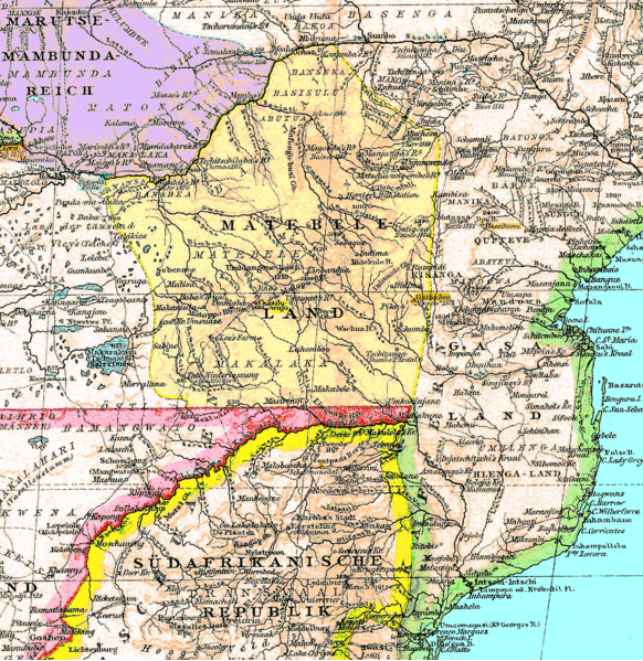
Matabeleland is a region located in southwestern Zimbabwe that is divided into three provinces: Matabeleland North, Bulawayo, and Matabeleland South. These provinces are in the west and south-west of Zimbabwe, between the Limpopo and Zambezi rivers and are further separated from Midlands by the Shangani River in central Zimbabwe. The region is named after its inhabitants, the Ndebele people who were called "Amatabele"(people with long spears - Mzilikazi 's group of people who were escaping the Mfecani wars). Other ethnic groups who inhabit parts of Matabeleland include the Tonga, Bakalanga, Venda, Nambya, Khoisan, Xhosa, Sotho, Tswana, and Tsonga. The population of Matabeleland is just over 20% of the Zimbabwe's total. The capital and largest city is Bulawayo, other notable towns are Plumtree, Victoria Falls, Beitbridge, Lupane, Esigodini, Hwange and Gwanda. The land is fertile but semi arid. This area has coal and gold deposits. Industries include gold and other minera ... [...More Info...] [...Related Items...] OR: [Wikipedia] [Google] [Baidu] |
Matabeleland South Province
Matabeleland South is a province in southwestern Zimbabwe. With a population of 683,893 as of the 2012 Zimbabwean census, it is the country's least populous province. After Matabeleland North, it is Zimbabwe's second-least densely populated province. Matabeleland South was established in 1974, when the original Matabeleland Province was divided into two provinces, the other being Matabeleland North. The province is divided into six districts. Gwanda is the capital, and Beitbridge is the province's largest town. The name "Matabeleland" is derived from Ndebele, the province's largest ethnic group. Matabeleland South is bordered by Bulawayo and Matabeleland North to the north, Midlands to the northeast, Masvingo to the southeast, South Africa to the south, and Botswana to the west. It has an area of , equal to 13.86% of the total area of Zimbabwe. It is the fourth-largest of the country's ten provinces in area. Matabeleland South sits on the edge of the Kalahari Desert, giving i ... [...More Info...] [...Related Items...] OR: [Wikipedia] [Google] [Baidu] |
Matabeleland North Province
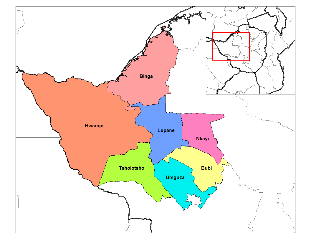
Matabeleland North is a province in western Zimbabwe. With a population of 749,017 as of the 2012 census, it is the country's second-least populous province, after Matabeleland South, and is the country's least densely populated province. Matabeleland North was established in 1974, when the original Matabeleland Province was divided into two provinces, the other being Matabeleland South. In 1997, the province lost territory when the city of Bulawayo became its own province. Matabeleland North is divided into seven districts. Its capital is Lupane, and Victoria Falls and Hwange are its largest towns. The name "Matabeleland" is derived from the Matabele or Ndebele people, the province's largest ethnic group. Matabeleland North is bordered by Matabeleland South and Bulawayo to the south, Midlands to the east, Mashonaland West to the northeast, Botswana to the west, and Zambia to the north, which is separated from Zimbabwe by the Zambezi river. It has an area of , equal to 19.2% of ... [...More Info...] [...Related Items...] OR: [Wikipedia] [Google] [Baidu] |
Zimbabwe
Zimbabwe (), officially the Republic of Zimbabwe, is a landlocked country located in Southeast Africa, between the Zambezi and Limpopo Rivers, bordered by South Africa to the south, Botswana to the south-west, Zambia to the north, and Mozambique to the east. The capital and largest city is Harare. The second largest city is Bulawayo. A country of roughly 15 million people, Zimbabwe has 16 official languages, with English, Shona language, Shona, and Northern Ndebele language, Ndebele the most common. Beginning in the 9th century, during its late Iron Age, the Bantu peoples, Bantu people (who would become the ethnic Shona people, Shona) built the city-state of Great Zimbabwe which became one of the major African trade centres by the 11th century, controlling the gold, ivory and copper trades with the Swahili coast, which were connected to Arab and Indian states. By the mid 15th century, the city-state had been abandoned. From there, the Kingdom of Zimbabwe was established, fol ... [...More Info...] [...Related Items...] OR: [Wikipedia] [Google] [Baidu] |
Lupane District
Lupane ( luːpɑːnɛ) District is located in the Matabeleland North Province of Zimbabwe, and it is also the Provincial Capital. The District is situated at an elevation of 976 m with a population of 198,600 inhabitants by 2019. Lupane Town is the main center of the district located 172 km from Bulawayo along the A8 Victoria Falls Road. The Government Provincial Administrative offices are located at the Town Centre. A new university near the Town has been established under the name Lupane State University, which caters for the region and beyond. The word Lupane is thought to be a Kalanga or Lozwi word. Geography Lupane is a rural semi-arid area with a growing population and some infrastructural expansion due to status of being accorded the capital of the province under government devolution. The area falls under Savannah climate with four seasons, the altitude rainfall patterns favours woodlands and grasslands depending on the location in the country. Climate Rains in ... [...More Info...] [...Related Items...] OR: [Wikipedia] [Google] [Baidu] |
Plumtree, Zimbabwe
Plumtree is a town in Zimbabwe. Alongside marula trees, wild plum trees (Ntungulu in tjiKalanga) grow abundantly in area. The town was once called ''Getjenge'' by baKalanga. Another name which is mainly used is ''Titji,'' meaning station and referring to the railway station which was operating in the area around 1897. Location The town is located in Bulilimamangwe District, in the Matabeleland South Province, in southwestern Zimbabwe, at the international border with Botswana. It is located about , by road, southwest of Bulawayo, the nearest large city. Plumtree sits on the main road between Bulawayo in Zimbabwe and Francistown in Botswana, about , further southwest from Plumtree. The geographical coordinates of Plumtree are: 20°28'41.0"S, 27°47'50.0"E (Latitude:-20.478056; Longitude:27.797222). The border is defined by the Ramokgwebana River. The village of Ramokgwebana is opposite Plumtree on the Botswana side. Plumtree lies at an average elevation of above mean sea lev ... [...More Info...] [...Related Items...] OR: [Wikipedia] [Google] [Baidu] |
Esigodini
Esigodini, previously known as Essexvale, is a town in the Matabeleland South Province of Zimbabwe. It is the administrative centre for Umzingwane District, one of the seven administrative districts in Matabeleland South. It was originally an estate of Frederick Selous. Location Esigodini is situated approximately , by road, southeast of Bulawayo, the nearest large city and largest urban centre in the province. The town sits along the Bulawayo–Beitbridge Road, approximately northwest of the town of Gwanda. The geographical coordinates of the town are:20°17'33.0"S, 28°56'17.0"E (Latitude:-20.292500; Longitude:28.938056). Esigodini is located at an average elevation of , above mean sea level. Overview Esigodini is the district capital of Umzingwane Rural District Council, which is responsible for running the affairs of the district as a whole. The trading centre is surrounded by ranches and mixed farms. The surrounding communities also host gold, dams and tungsten mines. ... [...More Info...] [...Related Items...] OR: [Wikipedia] [Google] [Baidu] |
Ndebele (Zimbabwe)
The Northern Ndebele people ( nd, amaNdebele) are an offshoot of the Bantu found in Southern Africa. Their three related Ndebele groups in South Africa are divided into (Northern and Southern Ndebele), the Northern Ndebele of South Africa comprise three tribes, namely ndebele of Langa/Laka, ndebele of Ndzundza & Mghumbhane/ mokopone-Mashashani who are ndebele of kekana (Manala) whereas the Southern Ndebele comprise mzilikazi they are a young compared to those of Langa & Ndzundza . This "Northern Ndebele" group from Zimbabwe is not the same as the Northern Ndebele group from South Africa and the two groups are not related either genealogically or historically, however, the Northern Ndebele and Southern Ndebele of South Africa are related genealogically and historically. They speak a language called isiNdebele. The Northern Ndebele were historically referred to as the Matabele by Sotho people, for a Nguni speaking person. Sotho people called all Nguni-speaking people 'Matebe ... [...More Info...] [...Related Items...] OR: [Wikipedia] [Google] [Baidu] |
Northern Ndebele People
The Northern Ndebele people ( nd, amaNdebele) are an offshoot of the Bantu found in Southern Africa. Their three related Ndebele groups in South Africa are divided into (Northern and Southern Ndebele), the Northern Ndebele of South Africa comprise three tribes, namely ndebele of Langa/Laka, ndebele of Ndzundza & Mghumbhane/ mokopone-Mashashani who are ndebele of kekana (Manala) whereas the Southern Ndebele comprise mzilikazi they are a young compared to those of Langa & Ndzundza . This "Northern Ndebele" group from Zimbabwe is not the same as the Northern Ndebele group from South Africa and the two groups are not related either genealogically or historically, however, the Northern Ndebele and Southern Ndebele of South Africa are related genealogically and historically. They speak a language called isiNdebele. The Northern Ndebele were historically referred to as the Matabele by Sotho people, for a Nguni speaking person. Sotho people called all Nguni-speaking people 'Matebe ... [...More Info...] [...Related Items...] OR: [Wikipedia] [Google] [Baidu] |
Gwanda
Gwanda is a town in Zimbabwe. It is the capital of the province of Matabeleland South, one of the ten administrative provinces in the country. It is also the district capital of Gwanda District, one of the seven administrative districts in the province. Location The town is located , by road, south east of the city of Bulawayo, Zimbabwe's second largest city. This location lies on the Bulawayo–Beitbridge Road and the Beitbridge Bulawayo Railway. The town of Beitbridge, at Zimbabwe's border with the Republic of South Africa, lies approximately , further southeast on Highway A-6. The coordinates of Gwanda, Zimbabwe are: 20°56'20.0"S, 29°01'07.0"E (Latitude:-20.938889; Longitude:29.018611). Gwanda sits at an average elevation of above mean sea level. Gwanda is known to have long, hot summers, and short, cool winters. Gwanda is also quite dry as compared to the rest of the country, and is therefore prone to drought. Overview Gwanda was founded in 1900 as a settlement of ... [...More Info...] [...Related Items...] OR: [Wikipedia] [Google] [Baidu] |
Bulawayo
Bulawayo (, ; Ndebele: ''Bulawayo'') is the second largest city in Zimbabwe, and the largest city in the country's Matabeleland region. The city's population is disputed; the 2022 census listed it at 665,940, while the Bulawayo City Council claimed it to be about 1.2 million. Bulawayo covers an area of about in the western part of the country, along the Matsheumhlope River. Along with the capital Harare, Bulawayo is one of two cities in Zimbabwe that is also a province. Bulawayo was founded by a group led by Gundwane Ndiweni around 1840 as the kraal of Mzilikazi, the Ndebele king and was known as Gibixhegu. His son, Lobengula, succeeded him in the 1860s, and changed the name to kobulawayo and ruled from Bulawayo until 1893, when the settlement was captured by British South Africa Company soldiers during the First Matabele War. That year, the first white settlers arrived and rebuilt the town. The town was besieged by Ndebele warriors during the Second Matabele War. Bulawayo ... [...More Info...] [...Related Items...] OR: [Wikipedia] [Google] [Baidu] |
Beitbridge
Beitbridge is a border town in the province of Matabeleland South, Zimbabwe. The name also refers to the border post and bridge spanning the Limpopo River, which forms the political border between South Africa and Zimbabwe. The border on the South African side of the river is also named Beitbridge. Background The town lies just north of the Limpopo River about 1 km from the Alfred Beit Road Bridge which spans the Limpopo between South Africa and Zimbabwe. The main roads are the A6 highway to Bulawayo and the Victoria Falls, being and away respectively and the A4 to Masvingo and Harare. According to the 2012 population census, the town had a population of 41,767 dominated by the Venda and Ndebele people . There is a sizable percentage of Shona people from other provinces this is a busy border post with traders from all over Zimbabwe. The Beitbridge border post is the busiest road border post in Southern Africa, and is best avoided during busy border-crossing seasons. ... [...More Info...] [...Related Items...] OR: [Wikipedia] [Google] [Baidu] |
Hwange
Hwange (formerly Wankie) is a town in Zimbabwe, located in Hwange District, in Matabeleland North Province, in northwestern Zimbabwe, close to the international borders with Botswana and Zambia. It lies approximately , by road, southeast of Victoria Falls, the nearest large city. The town lies on the railway line from Bulawayo, Zimbabwe's second-largest city, to Victoria Falls. Hwange sits at an elevation of , above sea level. Overview The town houses the offices of Hwange Town Council, as well as the headquarters of Hwange District Administration. Hwange and the surrounding countryside is a centre for the industry in Zimbabwe. Hwange Colliery is the largest in the country, with proven reserves that are estimated to last over 1,000 years, at current production levels. The Wankie Coal Field, one of the largest in the world, was discovered here in 1895 by the American Scout Frederick Russell Burnham. Today the coal for the whole country is transported by the mining railway to Th ... [...More Info...] [...Related Items...] OR: [Wikipedia] [Google] [Baidu] |


