|
Maryland Route 350
Maryland Route 350 (MD 350) is a state highway in the U.S. state of Maryland. Known as Mount Hermon Road, the state highway runs from Main Street in Salisbury east to MD 354 in Powellville. MD 350 provides access to a large area of farmland and forest in southeastern Wicomico County as well as Salisbury–Ocean City–Wicomico Regional Airport. The state highway was constructed from Salisbury to Mount Hermon in the 1910s and from Mount Hermon to Powellville in the first half of the 1930s. Route description MD 350 begins as the east leg of a six-way intersection in the city of Salisbury. Main Street, which was formerly U.S. Route 50 (US 50), runs through the intersection from southwest to northeast, while Long Avenue, Truitt Street, and William Street are the south, north, and west prongs of the junction, respectively. MD 350, which is maintained by the city of Salisbury for its first , heads east as a four-lane undivided highway, passing north of Wicomico High School. ... [...More Info...] [...Related Items...] OR: [Wikipedia] [Google] [Baidu] |
Maryland State Highway Administration
The Maryland State Highway Administration (abbreviated MDOT SHA or simply SHA) is the state transportation business unit responsible for maintaining Maryland's numbered highways outside Baltimore City. Formed originally under authority of the General Assembly of Maryland in 1908 as the State Roads Commission (S.R.C.), under the direction of the executive branch of state government headed by the Governor of Maryland, it is tasked with maintaining non-tolled/free bridges throughout the State, removing snow from the state's major thoroughfares, administering the State's "adopt-a-highway" program, and both developing and maintaining the State's freeway/expressway system. Since the reorganization of the several commissions, bureaus, boards, and assorted minor agencies with departments of the executive branch and establishment of the Governor's Cabinet in the early 1970s following the adoption of several individual reorganization recommendations after the rejection by the voters in a N ... [...More Info...] [...Related Items...] OR: [Wikipedia] [Google] [Baidu] |
Salisbury, Maryland
Salisbury () is a city in and the county seat of Wicomico County, Maryland, Wicomico County, Maryland, United States, and the largest city in Eastern Shore of Maryland, the state's Eastern Shore region. The population was 33,050 at the 2020 United States Census, 2020 census. Salisbury is the principal city of the Salisbury metropolitan area, Salisbury, Maryland-Delaware Metropolitan Statistical Area. The city is the commercial hub of the Delmarva Peninsula, which was long devoted to agriculture and had a southern culture. It calls itself "The Comfortable Side of Coastal". History Salisbury's location at the head of Wicomico River (Maryland eastern shore), Wicomico River was a major factor in growth. At first, it was a small colonial outpost set up by Cecilius Calvert, 2nd Baron Baltimore, Lord Baltimore. Salisbury's location at the head of the Wicomico River was seen to be a convenient location for trading purposes. Due to the similar physical attributes as well as the nationalit ... [...More Info...] [...Related Items...] OR: [Wikipedia] [Google] [Baidu] |
Powellville, Maryland
Powellville is an unincorporated community and census-designated place in Wicomico County, Maryland Maryland ( ) is a state in the Mid-Atlantic region of the United States. It shares borders with Virginia, West Virginia, and the District of Columbia to its south and west; Pennsylvania to its north; and Delaware and the Atlantic Ocean to ..., United States. Its population was 189 as of the 2010 census. It is part of the Salisbury, Maryland-Delaware Metropolitan Statistical Area. Demographics References Census-designated places in Maryland Census-designated places in Wicomico County, Maryland Salisbury metropolitan area {{WicomicoCountyMD-geo-stub ... [...More Info...] [...Related Items...] OR: [Wikipedia] [Google] [Baidu] |
Wicomico County, Maryland
Wicomico County () is located in the southeastern part of the U.S. state of Maryland, on the Delmarva Peninsula. As of the 2020 census, the population was 103,588. The county seat is Salisbury. The county was named for the Wicomico River, which in turn derives from Algonquian language words , meaning "a place where houses are built," apparently referring to a Native American town on the banks. Wicomico County is included in the Salisbury, MD-DE Metropolitan Statistical Area. The newspaper of record is ''The Daily Times.'' History Wicomico County was created from Somerset and Worcester counties in 1867. Politics and government Wicomico County was granted a charter form of government in 1964. In the period after the Reconstruction era, Wicomico County became solidly Democratic due to its strong support for secession and state efforts to disenfranchise most blacks by raising barriers to voter registration. Independent insurgent white groups worked to intimidate and discoura ... [...More Info...] [...Related Items...] OR: [Wikipedia] [Google] [Baidu] |
State Highway
A state highway, state road, or state route (and the equivalent provincial highway, provincial road, or provincial route) is usually a road that is either ''numbered'' or ''maintained'' by a sub-national state or province. A road numbered by a state or province falls below numbered national highways (Canada being a notable exception to this rule) in the hierarchy (route numbers are used to aid navigation, and may or may not indicate ownership or maintenance). Roads maintained by a state or province include both nationally numbered highways and un-numbered state highways. Depending on the state, "state highway" may be used for one meaning and "state road" or "state route" for the other. In some countries such as New Zealand, the word "state" is used in its sense of a sovereign state or country. By this meaning a state highway is a road maintained and numbered by the national government rather than local authorities. Countries Australia Australia's State Route system covers u ... [...More Info...] [...Related Items...] OR: [Wikipedia] [Google] [Baidu] |
Maryland
Maryland ( ) is a state in the Mid-Atlantic region of the United States. It shares borders with Virginia, West Virginia, and the District of Columbia to its south and west; Pennsylvania to its north; and Delaware and the Atlantic Ocean to its east. Baltimore is the largest city in the state, and the capital is Annapolis. Among its occasional nicknames are '' Old Line State'', the ''Free State'', and the '' Chesapeake Bay State''. It is named after Henrietta Maria, the French-born queen of England, Scotland, and Ireland, who was known then in England as Mary. Before its coastline was explored by Europeans in the 16th century, Maryland was inhabited by several groups of Native Americans – mostly by Algonquian peoples and, to a lesser degree, Iroquoian and Siouan. As one of the original Thirteen Colonies of England, Maryland was founded by George Calvert, 1st Baron Baltimore, a Catholic convert"George Calvert and Cecilius Calvert, Barons Baltimore" William Hand Browne, ... [...More Info...] [...Related Items...] OR: [Wikipedia] [Google] [Baidu] |
Maryland Route 354
Maryland Route 354 (MD 354) is a state highway in the U.S. state of Maryland. The state highway runs from MD 12 near Snow Hill north to MD 346 in Willards. MD 354 parallels the Pocomoke River, connecting eastern Wicomico County and northwestern Worcester with Snow Hill. The state highway was first constructed from Willards in the mid-1910s. The remainder of MD 354 was completed in the late 1920s and early 1930s, with little change in the highway since. Route description MD 354 begins at an intersection with MD 12 in the hamlet of Indiantown north of the town of Snow Hill. Nassawango Road heads southwest from the junction toward Pocomoke State Forest. MD 354 heads north as Whiton Road, a two-lane undivided road that passes through farmland and parallels the Pocomoke River at a distance. The state highway crosses Tilghman Race before passing through the hamlet of Whiton and entering Wicomico County, where the name of the highway changes to Powellville Road. In Powel ... [...More Info...] [...Related Items...] OR: [Wikipedia] [Google] [Baidu] |
Salisbury–Ocean City–Wicomico Regional Airport
Salisbury-Ocean City: Wicomico Regional Airport , or, more succinctly Salisbury Regional Airport, is located in unincorporated Wicomico County, Maryland, southeast from downtown Salisbury, Maryland, United States. Salisbury is the largest metropolitan area of Maryland's Eastern Shore with a population of 405,803 in the metropolitan statistical area, and is centrally located on the Delmarva Peninsula. Since SBY Regional Airport is the only commercial airport with daily scheduled flights in the area, it also serves Delaware, the Eastern Shore of Virginia, and the Eastern Shore of Maryland, which include the other towns of Ocean City, Cambridge, and Easton. American Eagle operates approximately two round trip flights per day to Charlotte Douglas International Airport, and two round trip flights per day to Philadelphia International Airport. History In 1940, Wicomico County and the City of Salisbury begun to construct the airport with the Works Progress Administration. It origin ... [...More Info...] [...Related Items...] OR: [Wikipedia] [Google] [Baidu] |
Mount Hermon, Maryland
Mount is often used as part of the name of specific mountains, e.g. Mount Everest. Mount or Mounts may also refer to: Places * Mount, Cornwall, a village in Warleggan parish, England * Mount, Perranzabuloe, a hamlet in Perranzabuloe parish, Cornwall, England * Mounts, Indiana, a community in Gibson County, Indiana, United States People * Mount (surname) * William L. Mounts (1862–1929), American lawyer and politician Computing and software * Mount (computing), the process of making a file system accessible * Mount (Unix), the utility in Unix-like operating systems which mounts file systems Displays and equipment * Mount, a fixed point for attaching equipment, such as a hardpoint on an airframe * Mounting board, in picture framing * Mount, a hanging scroll for mounting paintings * Mount, to display an item on a heavy backing such as foamcore, e.g.: ** To pin a biological specimen, on a heavy backing in a stretched stable position for ease of dissection or displa ... [...More Info...] [...Related Items...] OR: [Wikipedia] [Google] [Baidu] |
Wicomico High School
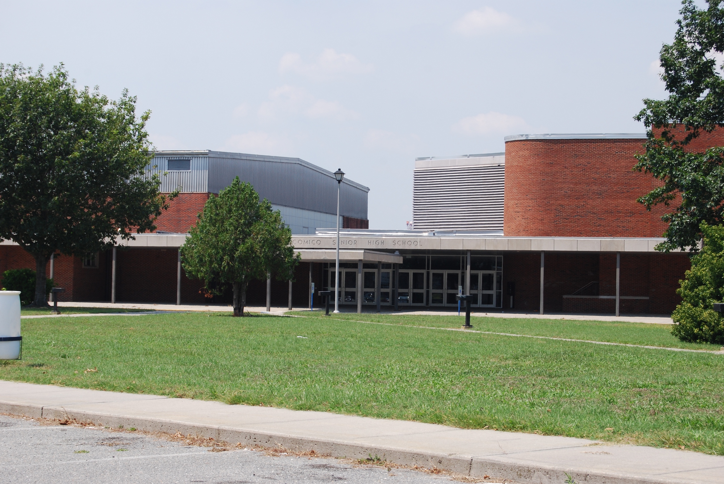
Wicomico High School (commonly abbreviated "Wi Hi") is a high school located in Salisbury, Wicomico County, Maryland, United States. It is one of four public high schools in Wicomico County along with James M. Bennett High School, Mardela Middle and High School and Parkside High School. Wicomico High School currently enrolls grades 9 through 12. Its mascot is the Indian and its colors are blue and gold. History In 1931, the school moved to its previous campus on East Main Street. The building was quickly outgrown, and in 1954 the current facility on Long Avenue was completed at a price of 1.5 million dollars, and was named Wicomico Senior High School. In 1995, it was renamed to Wicomico High School. The former high school building on East Main Street is now Wicomico Middle School. An administration building and an auditorium were added in 1975 and 1976. Additionally, extensive renovations were completed in 1995. At that time, Wicomico Senior High School was renamed Wicomico ... [...More Info...] [...Related Items...] OR: [Wikipedia] [Google] [Baidu] |
Limited-access Road
A limited-access road, known by various terms worldwide, including limited-access highway, dual-carriageway, expressway, limited access freeway, and partial controlled access highway, is a highway or arterial road for high-speed traffic which has many or most characteristics of a controlled-access highway (also known as a ''freeway'' or ''motorway''), including limited or no access to adjacent property, some degree of Dual carriageway, separation of opposing traffic flow, use of grade separated Interchange (road), interchanges to some extent, prohibition of slow modes of transport, such as bicycles, Working animal, (draught) horses, or self-propelled agricultural machines; and very few or no intersection (road), intersecting cross-streets or level crossings. The degree of isolation from local traffic allowed varies between countries and regions. The precise definition of these terms varies by jurisdiction.''Manual on Uniform Traffic Control Devices''Section 1A.13 Definitions of ... [...More Info...] [...Related Items...] OR: [Wikipedia] [Google] [Baidu] |

.jpg)


