|
Markerwaard
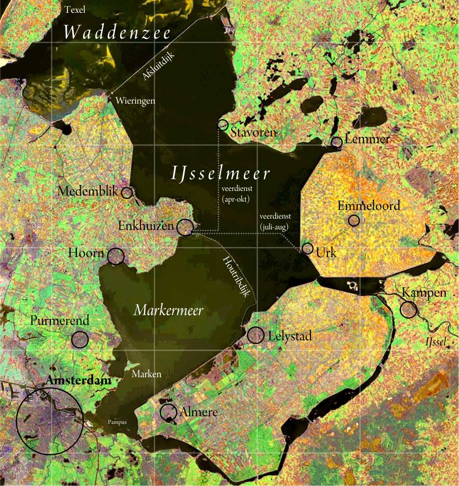
200px, The Markerwaard would be on what is now the Markermeer The Markerwaard is the name of a proposed, but never built, polder adjoining the IJsselmeer in the central Netherlands. Its construction would have resulted in the near-total reclamation of the Markermeer. Cornelis Lely's plan projected a polder in the south-west of the Zuiderzee, originally named ''Hoornsche Polder'', referring to Hoorn, then simply "Southwest Polder". Later the name was changed to Markerwaard Polder, after the island of Marken. However, reclamation of three other polders took place first, and preparations for the Markerwaard were being made while draining of the northeast and southeast polders (today's Flevoland) were underway. In 1941 work for this project started; about 2 km (1¼ miles) of a dike north of Marken was built. It would have had an area of nearly 600 km2 (200 sq. mi.). But the German occupation stopped the project. Later, it was decided that the Flevopolder should hav ... [...More Info...] [...Related Items...] OR: [Wikipedia] [Google] [Baidu] |
IJsselmeer Satellite
The IJsselmeer (; fy, Iselmar, nds-nl, Iesselmeer), also known as Lake IJssel in English, is a closed off inland bay in the central Netherlands bordering the provinces of Flevoland, North Holland and Friesland. It covers an area of with an average depth of . The river IJssel flows into the IJsselmeer. History Two thousand years ago Pomponius Mela, a Roman geographer, mentioned a complex of lakes at the current location of the IJsselmeer. He called it ''Lacus Flevo''. Over the centuries, the lake banks crumbled away due to flooding and wave action and the lake, now called the Almere, grew considerably. During the 12th and 13th centuries, storm surges and rising sea levels flooded large areas of land between the lake and the North Sea, turning the lake into a bay of the North Sea, called the Zuiderzee. The Zuiderzee continued to be a threat to the Dutch, especially when northwesterly storms funnel North Sea waters towards the English Channel, creating very high tides along ... [...More Info...] [...Related Items...] OR: [Wikipedia] [Google] [Baidu] |
IJsselmeer
The IJsselmeer (; fy, Iselmar, nds-nl, Iesselmeer), also known as Lake IJssel in English, is a closed off inland bay in the central Netherlands bordering the provinces of Flevoland, North Holland and Friesland. It covers an area of with an average depth of . The river IJssel flows into the IJsselmeer. History Two thousand years ago Pomponius Mela, a Roman geographer, mentioned a complex of lakes at the current location of the IJsselmeer. He called it '' Lacus Flevo''. Over the centuries, the lake banks crumbled away due to flooding and wave action and the lake, now called the Almere, grew considerably. During the 12th and 13th centuries, storm surges and rising sea levels flooded large areas of land between the lake and the North Sea, turning the lake into a bay of the North Sea, called the Zuiderzee. The Zuiderzee continued to be a threat to the Dutch, especially when northwesterly storms funnel North Sea waters towards the English Channel, creating very high tides ... [...More Info...] [...Related Items...] OR: [Wikipedia] [Google] [Baidu] |
Markermeer
The Markermeer () is a lake in the central Netherlands in between North Holland, Flevoland, and its smaller and larger neighbors, the IJmeer and IJsselmeer. A shallow lake at 3 to 5 m in depth, matching the reclaimed land to its west, north-west and east it is named after the small former island, now peninsula, of Marken on its west shore. The Markermeer was not originally intended to remain a lake. It was formerly part of the Zuiderzee, a saltwater inlet of the North Sea, that was dammed off by the ''Afsluitdijk'' (Closure Dike) in 1932, turning the Zuiderzee into the freshwater IJsselmeer. The following years saw the reclamation of extensive tracts of land as large polders in an enormous project known as the Zuiderzee Works. One of these, the Markerwaard, was to occupy the area of the current Markermeer. Part of the construction of this polder was building the ''Houtribdijk'', also called ''Markerwaarddijk'', finished in 1976, which hydrologically splits the IJsselme ... [...More Info...] [...Related Items...] OR: [Wikipedia] [Google] [Baidu] |
Houtribdijk
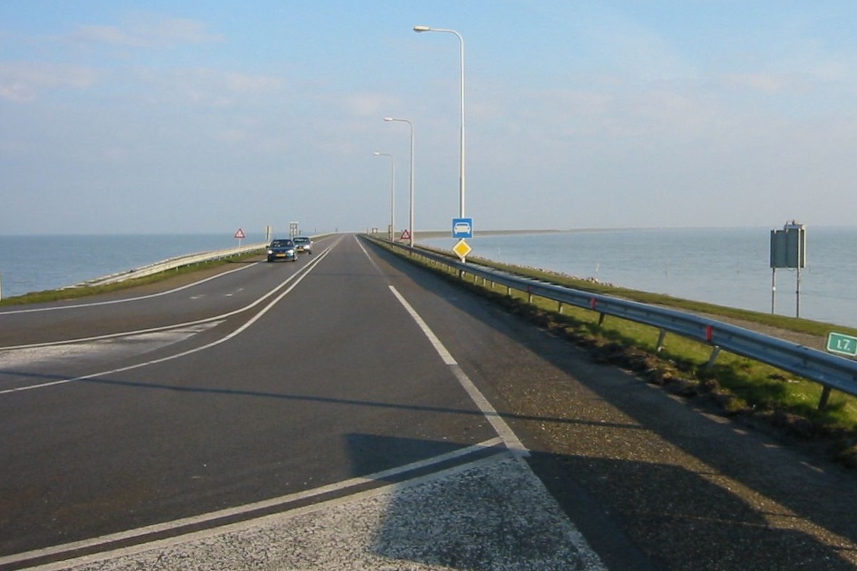
The Houtribdijk is a dam in the Netherlands, built between 1963 and 1975 as part of the Zuiderzee Works, which connects the cities of Lelystad and Enkhuizen. On the west side of the dike is the Markermeer and on the east is the IJsselmeer. The 27-kilometer-long dike was intended for the Markerwaard, but this polder is now unlikely to be constructed. Although called a ''dike'' (withholding water from land area), the Houtribdijk is actually a '' dam'' (separating water bodies). Parts of the dike are known as the ''Markerwaarddijk'' and the ''Lelydijk''. It is also frequently called the "Enkhuizen–Lelystad dike" in traffic announcements, as if it had no official name. The road that runs on the dike is the N302 and is used by 8,500 vehicles per day with a speed limit of 100 km/h. The road also features a biking path alongside the N302 Provincial road N302 (N302) is a road connecting Rijksweg 7 (A7) / European route E22 (E 22) in Hoorn with A1 / E 30 near ... [...More Info...] [...Related Items...] OR: [Wikipedia] [Google] [Baidu] |
Flevoland
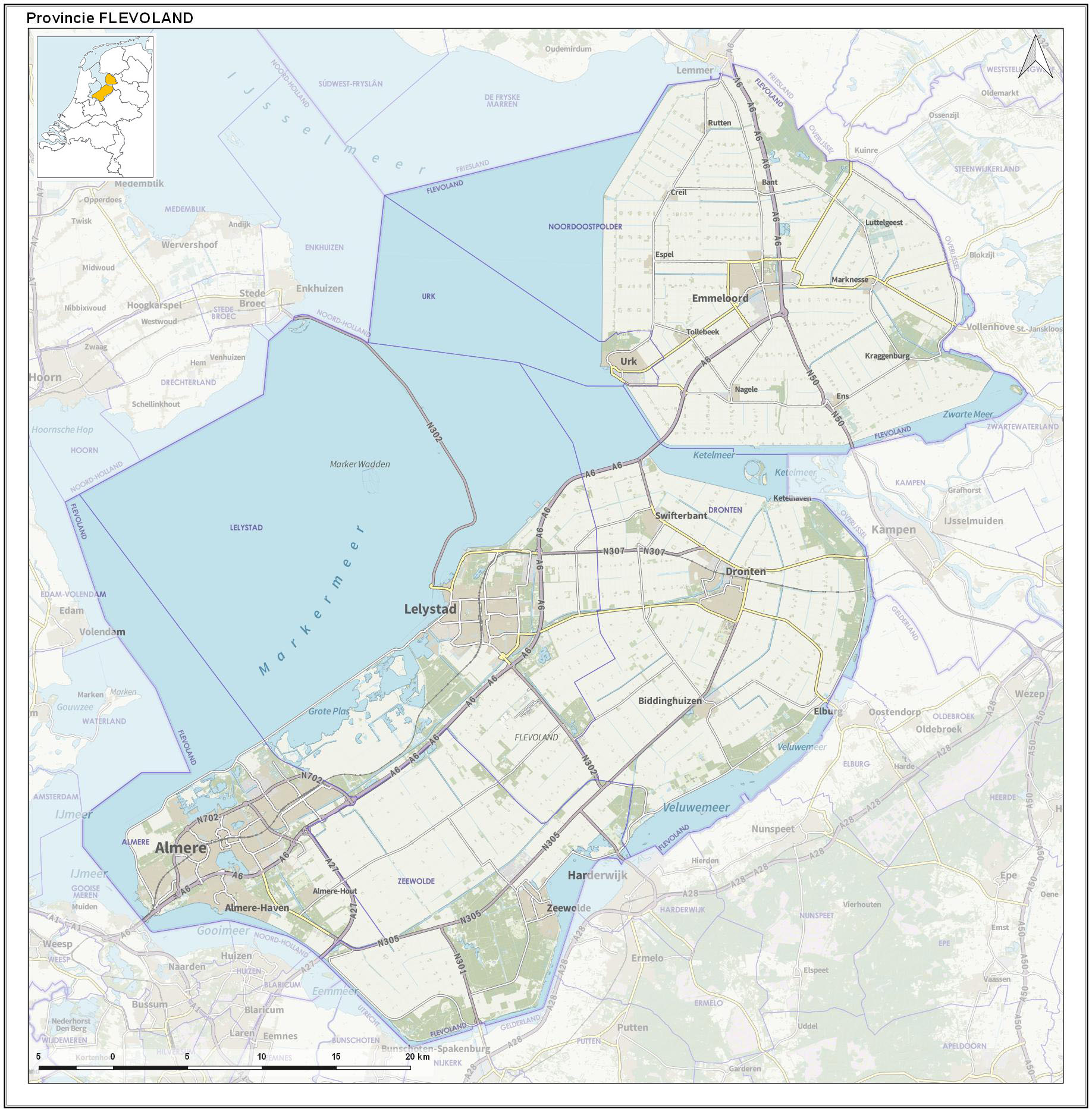
Flevoland () is the twelfth and youngest province of the Netherlands, established in 1986, when the southern and eastern Flevopolders, together with the Noordoostpolder, were merged into one provincial entity. It is in the centre of the country in the former Zuiderzee, which was turned into the freshwater IJsselmeer by the closure of the Afsluitdijk in 1932. Almost all of the land belonging to Flevoland was reclaimed in the 1950s and 1960s while splitting the Markermeer and Bordering lakes from the IJsselmeer. As to dry land, it is the smallest province of the Netherlands at , but not gross land as that includes much of the waters of the fresh water lakes (meres) mentioned. The province has a population of 423,021 as of January 2020 and consists of six municipalities. Its capital is Lelystad and its most populous city is Almere, which forms part of the Randstad and has grown to become the seventh largest city of the country. Flevoland is bordered in the extreme north ... [...More Info...] [...Related Items...] OR: [Wikipedia] [Google] [Baidu] |
Zuiderzee
The Zuiderzee or Zuider Zee (; old spelling ''Zuyderzee'' or ''Zuyder Zee'') was a shallow bay of the North Sea in the northwest of the Netherlands, extending about 100 km (60 miles) inland and at most 50 km (30 miles) wide, with an overall depth of about 4 to 5 metres (13–16 feet) and a coastline of about 300 km (200 miles). It covered . Its name is Dutch for "southern sea", indicating that the name originates in Friesland, to the north of the Zuiderzee (cf. North Sea). In the 20th century the majority of the Zuiderzee was closed off from the North Sea by the construction of the Afsluitdijk, leaving the mouth of the inlet to become part of the Wadden Sea. The salt water inlet changed into a fresh water lake now called the IJsselmeer (IJssel Lake) after the river that drains into it, and by means of drainage and polders, an area of some was reclaimed as land. This land eventually became the province of Flevoland, with a population of nearly 400,000 (2011 ... [...More Info...] [...Related Items...] OR: [Wikipedia] [Google] [Baidu] |
Marken
Marken (; Marken's dialect: ''Mereke'') is a village in the municipality of Waterland in the province of North Holland, Netherlands. It had a population of 1,745 as of 2021, and occupies a peninsula in the Markermeer. It was, until 1957, an island in the former Zuiderzee. The characteristic wooden houses of Marken are a tourist attraction. History Early years Marken was an island in the Zuiderzee. For some time during the later 19th and early 20th centuries, Marken and its inhabitants were the focus of considerable attention by folklorists, ethnographers and physical anthropologists, who regarded the small fishing town as a relic of the traditional native culture that was destined to disappear as modernization of the Netherlands gained pace. Among them were Johann Friedrich Blumenbach who examined a human skull from the island which he called Batavus genuinus; and was the Belgian painter Xavier Mellery who stayed in Marken at the request of Charles De Coster. Mellery was asked to ... [...More Info...] [...Related Items...] OR: [Wikipedia] [Google] [Baidu] |
Schiphol Airport
Amsterdam Airport Schiphol , known informally as Schiphol Airport ( nl, Luchthaven Schiphol, ), is the main international airport of the Netherlands. It is located southwest of Amsterdam, in the municipality of Haarlemmermeer in the province of North Holland. It is the world's third busiest airport by international passenger traffic in 2021. With almost 72 million passengers in 2019, it is the third-busiest airport in Europe in terms of passenger volume and the busiest in Europe in terms of aircraft movements. With an annual cargo tonnage of 1.74 million, it is the 4th busiest in Europe. AMS covers a total area of of land. The airport is built on the single-terminal concept: one large terminal split into three large departure halls. Schiphol is the hub for KLM and its regional affiliate KLM Cityhopper as well as for Corendon Dutch Airlines, Martinair, Transavia and TUI fly Netherlands. The airport also serves as a base for EasyJet. Schiphol opened on 16 September ... [...More Info...] [...Related Items...] OR: [Wikipedia] [Google] [Baidu] |
Polders Of North Holland
A polder () is a low-lying tract of land that forms an artificial hydrological entity, enclosed by embankments known as dikes. The three types of polder are: # Land reclaimed from a body of water, such as a lake or the seabed # Flood plains separated from the sea or river by a dike # Marshes separated from the surrounding water by a dike and subsequently drained; these are also known as ''koogs'', especially in Germany The ground level in drained marshes subsides over time. All polders will eventually be below the surrounding water level some or all of the time. Water enters the low-lying polder through infiltration and water pressure of groundwater, or rainfall, or transport of water by rivers and canals. This usually means that the polder has an excess of water, which is pumped out or drained by opening sluices at low tide. Care must be taken not to set the internal water level too low. Polder land made up of peat (former marshland) will sink in relation to its previous le ... [...More Info...] [...Related Items...] OR: [Wikipedia] [Google] [Baidu] |
Land Reclamation
Land reclamation, usually known as reclamation, and also known as land fill (not to be confused with a waste landfill), is the process of creating new land from oceans, seas, riverbeds or lake beds. The land reclaimed is known as reclamation ground or land fill. In some jurisdictions, including parts of the United States, the term "reclamation" can refer to returning disturbed lands to an improved state. In Alberta, Canada, for example, reclamation is defined by the provincial government as "The process of reconverting disturbed land to its former or other productive uses." In Oceania, it is frequently referred to as land rehabilitation. History One of the earliest large-scale projects was the Beemster Polder in the Netherlands, realized in 1612 adding of land. In Hong Kong the Praya Reclamation Scheme added of land in 1890 during the second phase of construction. It was one of the most ambitious projects ever taken during the Colonial Hong Kong era.Bard, Solomon. ... [...More Info...] [...Related Items...] OR: [Wikipedia] [Google] [Baidu] |
Freshwater Ecology
Freshwater ecosystems are a subset of Earth's aquatic ecosystems. They include lakes, ponds, rivers, streams, springs, bogs, and wetlands. They can be contrasted with marine ecosystems, which have a larger salt content. Freshwater habitats can be classified by different factors, including temperature, light penetration, nutrients, and vegetation. There are three basic types of freshwater ecosystems: Lentic (slow moving water, including pools, ponds, and lakes), lotic (faster moving water, for example streams and rivers) and wetlands (areas where the soil is saturated or inundated for at least part of the time). Freshwater ecosystems contain 41% of the world's known fish species. Freshwater ecosystems have undergone substantial transformations over time, which has impacted various characteristics of the ecosystems. Original attempts to understand and monitor freshwater ecosystems were spurred on by threats to human health (for example cholera outbreaks due to sewage contaminatio ... [...More Info...] [...Related Items...] OR: [Wikipedia] [Google] [Baidu] |
Environmental Soil Science
Environmental soil science is the study of the interaction of humans with the pedosphere as well as critical aspects of the biosphere, the lithosphere, the hydrosphere, and the atmosphere. Environmental soil science addresses both the fundamental and applied aspects of the field including: buffers and surface water quality, vadose zone functions, septic drain field site assessment and function, land treatment of wastewater, stormwater, erosion control, soil contamination with metals and pesticides, remediation of contaminated soils, restoration of wetlands, soil degradation, nutrient management, movement of viruses and bacteria in soils and waters, bioremediation, application of molecular biology and genetic engineering to development of soil microbes that can degrade hazardous pollutants, land use, global warming In common usage, climate change describes global warming—the ongoing increase in global average temperature—and its effects on Earth's clima ... [...More Info...] [...Related Items...] OR: [Wikipedia] [Google] [Baidu] |


