|
MODIS
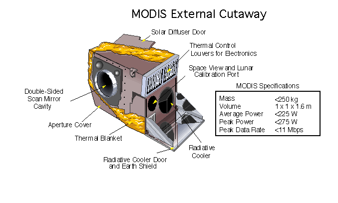
The Moderate Resolution Imaging Spectroradiometer (MODIS) is a satellite-based sensor used for earth and climate measurements. There are two MODIS sensors in Earth orbit: one on board the Terra (EOS AM) satellite, launched by NASA in 1999; and one on board the Aqua (EOS PM) satellite, launched in 2002. Since 2011, MODIS operations have been supplemented by VIIRS sensors, such as the one aboard Suomi NPP. The systems often conduct similar operations due to their similar designs and orbits (with VIIRS data systems deisgned to be compatible with MODIS), though they have subtle differences contributing to similar but not identical uses. The MODIS instruments were built by Santa Barbara Remote Sensing. They capture data in 36 spectral bands ranging in wavelength from 0.4 μm to 14.4 μm and at varying spatial resolutions (2 bands at 250 m, 5 bands at 500 m and 29 bands at 1 km). Together the instruments image the entire Earth every 1 to 2 days. They are designed ... [...More Info...] [...Related Items...] OR: [Wikipedia] [Google] [Baidu] |
Ocean Color
Ocean color is the branch of ocean optics that specifically studies the color of the water and information that can be gained from looking at variations in color. The color of the ocean, while mainly blue, actually varies from blue to green or even yellow, brown or red in some cases. This field of study developed alongside water remote sensing, so it is focused mainly on how color is measured by instruments (like the sensors on satellites and airplanes). Most of the ocean is blue in color, but in some places the ocean is blue-green, green, or even yellow to brown. Blue ocean color is a result of several factors. First, water preferentially absorbs red light, which means that blue light remains and is reflected back out of the water. Red light is most easily absorbed and thus does not reach great depths, usually to less than 50 meters (164 ft). Blue light, in comparison, can penetrate up to 200 meters (656 ft). Second, water molecules and very tiny particles in ocean wat ... [...More Info...] [...Related Items...] OR: [Wikipedia] [Google] [Baidu] |
Earth Observing System
The Earth Observing System (EOS) is a program of NASA comprising a series of artificial satellite missions and scientific instruments in Earth orbit designed for long-term global observations of the land surface, biosphere, earth's atmosphere, atmosphere, and oceans. Since the early 1970s, NASA has been developing its Earth Observing System, launching a series of Landsat program, Landsat satellites in the decade. Some of the first included Passive microwave sensor, passive microwave imaging in 1972 through the Nimbus 5 satellite. Following the launch of various satellite missions, the conception of the program began in the late 1980s and expanded rapidly through the 1990s. Since the inception of the program, it has continued to develop, including; land, sea, radiation and atmosphere. Collected in a system known as EOSDIS, NASA uses this data in order to study the progression and changes in the biosphere of Earth. The main focus of this data collection surrounds climatic science. Th ... [...More Info...] [...Related Items...] OR: [Wikipedia] [Google] [Baidu] |
Albedo
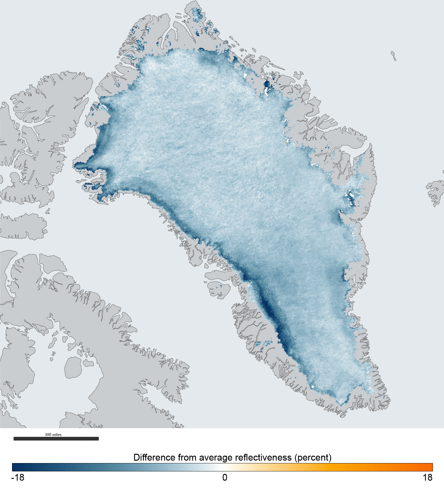
Albedo ( ; ) is the fraction of sunlight that is Diffuse reflection, diffusely reflected by a body. It is measured on a scale from 0 (corresponding to a black body that absorbs all incident radiation) to 1 (corresponding to a body that reflects all incident radiation). ''Surface albedo'' is defined as the ratio of Radiosity (radiometry), radiosity ''J''e to the irradiance ''E''e (flux per unit area) received by a surface. The proportion reflected is not only determined by properties of the surface itself, but also by the spectral and angular distribution of solar radiation reaching the Earth's surface. These factors vary with atmospheric composition, geographic location, and time (see position of the Sun). While directional-hemispherical reflectance factor is calculated for a single angle of incidence (i.e., for a given position of the Sun), albedo is the directional integration of reflectance over all solar angles in a given period. The temporal resolution may range from seconds ... [...More Info...] [...Related Items...] OR: [Wikipedia] [Google] [Baidu] |
Cloud Cover
Cloud cover (also known as cloudiness, cloudage, or cloud amount) refers to the fraction of the sky obscured by clouds on average when observed from a particular location. Okta is the usual unit for measurement of the cloud cover. The cloud cover is correlated to the sunshine duration as the least cloudy locales are the sunniest ones while the cloudiest areas are the least sunny places, as clouds can block sunlight, especially at sunrise and sunset where sunlight is already limited. The global cloud cover averages around 67-68%, though it ranges from 56% to 73% depending on the minimum optical depth considered (lower when optical depth is large, and higher when it is low, such that subvisible cirrus clouds are counted). Average cloud cover is around 72% over the oceans, with low seasonal variation, and about 55% above land, with significant seasonal variation. Role in the climate system Clouds play multiple critical roles in the climate system and diurnal cycle. In ... [...More Info...] [...Related Items...] OR: [Wikipedia] [Google] [Baidu] |
VIIRS
The Visible Infrared Imaging Radiometer Suite (VIIRS) is a sensor designed and manufactured by the Raytheon Company on board the polar-orbiting Suomi National Polar-orbiting Partnership (Suomi NPP), NOAA-20, and NOAA-21 weather satellites. VIIRS is one of five key instruments onboard Suomi NPP, launched on October 28, 2011. VIIRS is a whiskbroom scanner radiometer that collects imagery and radiometric measurements of the land, atmosphere, cryosphere, and oceans in the visible and infrared bands of the electromagnetic spectrum. VIIRS is capable of generating two data processing streams that result in two different sets of land products, with global coverage every 14 hours. One is produced by NOAA, and provides operational data for use by the National Weather Service. These are known as environmental data records (EDRs). The other stream is from NASA, and is intended to contribute to the larger scientific community. These are known as Earth System Data Records (ESDRs). VIIRS's m ... [...More Info...] [...Related Items...] OR: [Wikipedia] [Google] [Baidu] |
Aqua (satellite)
Aqua (EOS PM-1) is a NASA scientific research satellite in orbit around the Earth, studying the Precipitation (meteorology), precipitation, evaporation, and Water cycle, cycling of water. It is the second major component of the Earth Observing System (EOS) preceded by Terra (satellite), Terra (launched 1999) and followed by Aura (satellite), Aura (launched 2004). The name "Aqua" comes from the Latin word for water. The satellite was launched from Vandenberg Air Force Base on May 4, 2002, aboard a Delta II Launch vehicle, rocket. Aqua operated in a Sun-synchronous orbit as the third in the satellite formation called the "A-train (satellite constellation), A Train" with several other satellites (OCO-2, the Japanese GCOM, GCOM W1, PARASOL, CALIPSO, CloudSat, and Aura (satellite), Aura) for most of its first 20 years; but in January 2022 Aqua left the A-Train (as Cloud Sat, CALIPSO and PARASOL had already done) when, due to its fuel limitations, it transitioned to a free-drift mode, w ... [...More Info...] [...Related Items...] OR: [Wikipedia] [Google] [Baidu] |
Wildland Fires
A wildfire, forest fire, or a bushfire is an unplanned and uncontrolled fire in an area of combustible vegetation. Depending on the type of vegetation present, a wildfire may be more specifically identified as a bushfire ( in Australia), desert fire, grass fire, hill fire, peat fire, prairie fire, vegetation fire, or veld fire. Some natural forest ecosystems depend on wildfire. Modern forest management often engages in prescribed burns to mitigate fire risk and promote natural forest cycles. However, controlled burns can turn into wildfires by mistake. Wildfires can be classified by cause of ignition, physical properties, combustible material present, and the effect of weather on the fire. Wildfire severity results from a combination of factors such as available fuels, physical setting, and weather. Climatic cycles with wet periods that create substantial fuels, followed by drought and heat, often precede severe wildfires. These cycles have been intensified by climate change,Pa ... [...More Info...] [...Related Items...] OR: [Wikipedia] [Google] [Baidu] |
Terra (satellite)
Terra (EOS AM-1) is a multi-national scientific research satellite operated by NASA in a Sun-synchronous orbit around the Earth. It takes simultaneous measurements of Earth's atmosphere, land, and water to understand how Earth is changing and to identify the consequences for life on Earth. It is the flagship of the Earth Observing System (EOS) and the first satellite of the system which was followed by Aqua (launched in 2002) and Aura (launched in 2004). Terra was launched in 1999. The name "Terra" comes from the Latin word for Earth. A naming contest was held by NASA among U.S. high school students. The winning essay was submitted by Sasha Jones of Brentwood, Missouri. The identifier "AM-1" refers to its orbit, passing over the equator in the morning. Launch The satellite was launched from Vandenberg Air Force Base on December 18th, 1999, aboard an Atlas IIAS vehicle and began collecting data on February 24th, 2000. It was placed into a near-polar, sun-synchrono ... [...More Info...] [...Related Items...] OR: [Wikipedia] [Google] [Baidu] |
Phenology
Phenology is the study of periodic events in biological life cycles and how these are influenced by seasonal and interannual variations in climate, as well as habitat factors (such as elevation). Examples include the date of emergence of leaves and flowers, the first flight of butterflies, the first appearance of migratory birds, the date of leaf colouring and fall in deciduous trees, the dates of egg-laying of birds and amphibia, or the timing of the developmental cycles of temperate-zone honey bee colonies. In the scientific literature on ecology, the term is used more generally to indicate the time frame for any seasonal biological phenomena, including the dates of last appearance (e.g., the seasonal phenology of a species may be from April through September). Because many such phenomena are very sensitive to small variations in climate, especially to temperature, phenological records can be a useful proxy for temperature in historical climatology, especially in the ... [...More Info...] [...Related Items...] OR: [Wikipedia] [Google] [Baidu] |
Bidirectional Reflectance Distribution Function
The bidirectional reflectance distribution function (BRDF), symbol f_(\omega_,\, \omega_), is a function of four real variables that defines how light from a source is reflected off an Opacity (optics), opaque surface. It is employed in the optics of real-world light, in computer graphics algorithms, and in computer vision algorithms. The function takes an incoming light direction, \omega_, and outgoing direction, \omega_ (taken in a coordinate system where the Normal (geometry), surface normal \mathbf n lies along the ''z''-axis), and returns the ratio of reflected radiance exiting along \omega_ to the irradiance incident on the surface from direction \omega_. Each direction \omega is itself Spherical coordinate system, parameterized by azimuth angle \phi and zenith angle \theta, therefore the BRDF as a whole is a function of 4 variables. The BRDF has units sr−1, with steradians (sr) being a unit of solid angle. Definition The BRDF was first defined by Fred Nicodemus around 19 ... [...More Info...] [...Related Items...] OR: [Wikipedia] [Google] [Baidu] |


