|
List Of Bridges In The United Kingdom
Bridges in the United Kingdom is a link page for any road bridges or footbridges in the United Kingdom. Railway bridges are listed under: List of railway bridges and viaducts in the United Kingdom. Canal aqueducts are listed under: List of canal aqueducts in the United Kingdom England Greater London Rest of England England and Wales England and Scotland Scotland Glasgow All bridges are over the River Clyde unless otherwise specified. Rest of Scotland Northern Ireland Wales *Brecon, Usk Bridge *Britannia Bridge * Briton Ferry Bridge, carries the M4 over the River Neath south of the town of Neath *Cardiff, Cardiff Bridge *Conwy Suspension Bridge, by Thomas Telford *Menai Suspension Bridge, by Thomas Telford * Monnow Bridge, Monmouth * Newport Bridge * Newport, Caerleon Bridge *Newport, City Bridge *Newport City footbridge *Newport, George Street Bridge *Newport, M4 motorway Usk bridge *Newport Transporter Bridge *Waterloo Bridge, Betws-y-Coed, by Thomas Telfo ... [...More Info...] [...Related Items...] OR: [Wikipedia] [Google] [Baidu] |
Road Bridge
A bridge is a structure built to span a physical obstacle (such as a body of water, valley, road, or rail) without blocking the way underneath. It is constructed for the purpose of providing passage over the obstacle, which is usually something that is otherwise difficult or impossible to cross. There are many different designs of bridges, each serving a particular purpose and applicable to different situations. Designs of bridges vary depending on factors such as the function of the bridge, the nature of the terrain where the bridge is constructed and anchored, and the material used to make it, and the funds available to build it. The earliest bridges were likely made with fallen trees and stepping stones. The Neolithic people built boardwalk bridges across marshland. The Arkadiko Bridge (dating from the 13th century BC, in the Peloponnese) is one of the oldest arch bridges still in existence and use. Etymology The ''Oxford English Dictionary'' traces the origin of the wo ... [...More Info...] [...Related Items...] OR: [Wikipedia] [Google] [Baidu] |
Golden Jubilee Bridges
The Hungerford Bridge crosses the River Thames in London, and lies between Waterloo Bridge and Westminster Bridge. Owned by Network Rail Infrastructure Ltd (who use its official name of Charing Cross Bridge) it is a steel truss railway bridge flanked by two more recent, cable-stayed, pedestrian bridges that share the railway bridge's foundation piers, and which are named the Golden Jubilee Bridges. The north end of the bridge is Charing Cross railway station, and is near Embankment Pier and the Victoria Embankment. The south end is near Waterloo station, County Hall, the Royal Festival Hall, and the London Eye. Each pedestrian bridge has steps and lift access. History The first Hungerford Bridge, designed by Isambard Kingdom Brunel, opened in 1845 as a suspension footbridge. It was named after the then Hungerford Market, because it went from the South Bank, specifically a northern point of Lambeth, soon close to London Waterloo station to that place on the north side of th ... [...More Info...] [...Related Items...] OR: [Wikipedia] [Google] [Baidu] |
Lambeth
Lambeth () is a district in South London, England, in the London Borough of Lambeth, historically in the County of Surrey. It is situated south of Charing Cross. The population of the London Borough of Lambeth was 303,086 in 2011. The area experienced some slight growth in the medieval period as part of the manor of Lambeth Palace. By the Victorian era the area had seen significant development as London expanded, with dense industrial, commercial and residential buildings located adjacent to one another. The changes brought by World War II altered much of the fabric of Lambeth. Subsequent development in the late 20th and early 21st centuries has seen an increase in the number of high-rise buildings. The area is home to the International Maritime Organization. Lambeth is home to one of the largest Lusophone, Portuguese-speaking communities in the UK, and is the second most commonly spoken language in Lambeth after English language, English. History Medieval The origins of the ... [...More Info...] [...Related Items...] OR: [Wikipedia] [Google] [Baidu] |
Westminster
Westminster is an area of Central London, part of the wider City of Westminster. The area, which extends from the River Thames to Oxford Street, has many visitor attractions and historic landmarks, including the Palace of Westminster, Buckingham Palace, Westminster Abbey, Westminster Cathedral and much of the West End shopping and entertainment district. The name ( ang, Westmynstre) originated from the informal description of the abbey church and royal peculiar of St Peter's (Westminster Abbey), west of the City of London (until the English Reformation there was also an Eastminster, near the Tower of London, in the East End of London). The abbey's origins date from between the 7th and 10th centuries, but it rose to national prominence when rebuilt by Edward the Confessor in the 11th. Westminster has been the home of England's government since about 1200, and from 1707 the Government of the United Kingdom. In 1539, it became a city. Westminster is often used as a m ... [...More Info...] [...Related Items...] OR: [Wikipedia] [Google] [Baidu] |
Lambeth Bridge
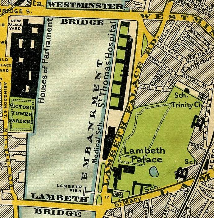
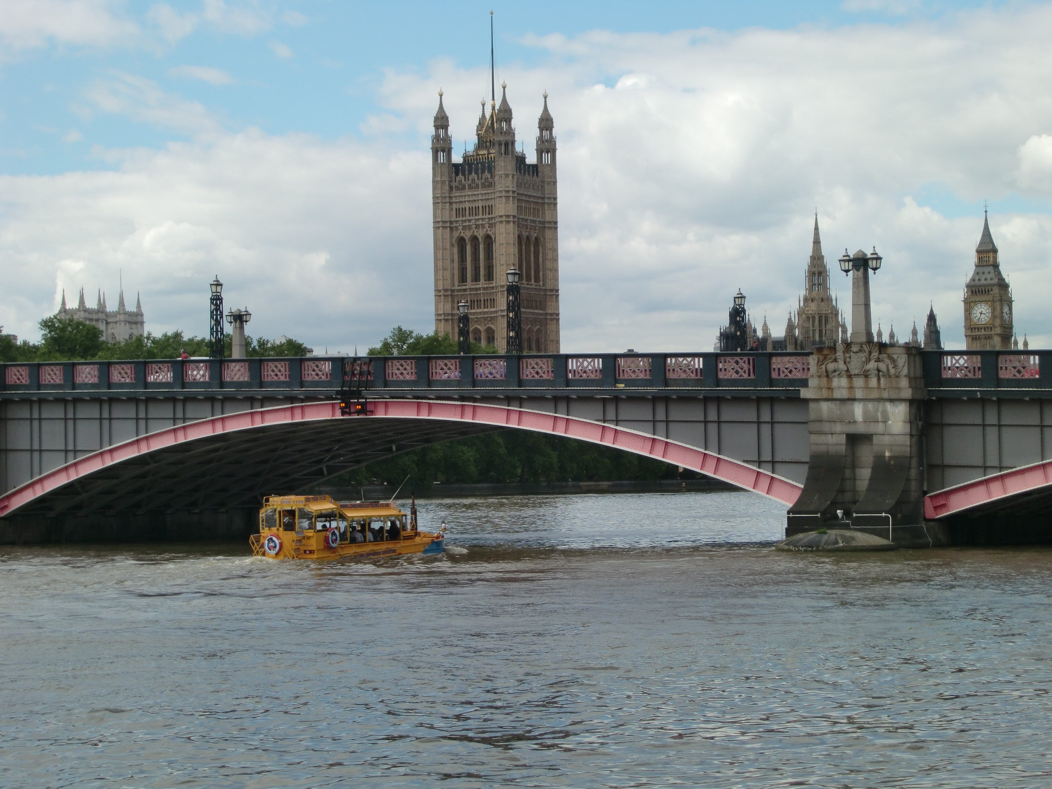
Lambeth Bridge is a road traffic and footbridge crossing the River Thames in an east–west direction in central London. The river flows north at the crossing point. Downstream, the next bridge is Westminster Bridge; upstream, the next bridge is Vauxhall Bridge. The most conspicuous colour in the bridge's paint scheme is red, the same colour as the leather benches in the House of Lords, which is at the southern end of the Palace of Westminster nearest the bridge. This is in contrast to Westminster Bridge, which is predominantly green, the same colour as the benches in the House of Commons at the northern end of the Houses of Parliament. On the east side, in Lambeth, are Lambeth Palace, the Albert Embankment, St. Thomas' Hospital, and the International Maritime Organization. On the west side, in Westminster, are Thames House (the headquarters of MI5), behind which is Horseferry House (the National Probation Service headquarters), and Clelland House and Abell House (the headquar ... [...More Info...] [...Related Items...] OR: [Wikipedia] [Google] [Baidu] |
Kew Bridge
Kew Bridge is a wide-span bridge over the Tideway (upper estuary of the Thames) linking the London Boroughs of Richmond upon Thames and Hounslow. The present bridge, which was opened in 1903 as King Edward VII Bridge by King Edward VII and Queen Alexandra, A plaque, now faded, on the bridge reads: was designed by John Wolfe-Barry and Cuthbert A Brereton. Historic England listed it at Grade II in 1983. Location Kew Bridge crosses the west of the Tideway between the Kew Green neighbourhood of Kew on the south bank and Brentford on the north bank. Its southern approach adjoins the Royal Botanic Gardens; the northern adjoins the former Grand Junction Waterworks Company buildings and reservoirs (the remnant of which is the London Museum of Water & Steam). The bridge forms a primary route joining the South Circular and North Circular roads to the west of London, and can be very congested. On the eastward Kew bank is Kew Pier, which serves tourist ferries operating under lice ... [...More Info...] [...Related Items...] OR: [Wikipedia] [Google] [Baidu] |
East Molesey
Molesey is a district of two twin towns, East Molesey and West Molesey, in the Borough of Elmbridge, Surrey, England, and is situated on the south bank of the River Thames. East and West Molesey share a high street, and there is a second retail restaurant-lined street (Bridge Road) close to Hampton Court Palace in the eastern part of the district, which is also home to Hampton Court railway station in Transport for London's Zone 6. Molesey Hurst or Hurst Park is a large park by the River Thames in the north of the area, and is home to East Molesey Cricket Club. The Hampton Ferry runs from here to Hampton on the Middlesex bank, from where it is a short walk to the central area of Hampton. Molesey is divided into three wards: Molesey South, East and North. The majority of Molesey's detached properties are in the east, which also contains the highest proportion of apartments of the three wards. Molesey forms part of the Greater London Built-up Area. History The earliest docu ... [...More Info...] [...Related Items...] OR: [Wikipedia] [Google] [Baidu] |

.jpg)


