|
Lake Polyfytos Bridge
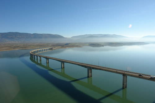
The Servia High Bridge ( el, Υψηλή Γέφυρα Σερβίων, translit=Ypsili Gefyra Servion) is one of the longest bridges in Greece, with a length of 1,372 m. Construction began in 1972 along with the artificial lake and was completed in 1975. Designed by Riccardo Morandi, was constructed from a joint venture Xekte SA–Skapaneus SA. The bridge is a part of the GR-3/ E65 (Athens - Lamia - Larissa - Kozani - Florina) and is located 15 km southeast of the city of Kozani and 5 km northwest of Servia. It is one of the two bridges of the lake; the other is the Rymnios Bridge to the southwest near Aiani and is smaller, with 615 m length. Structural issues raised in 2020 In January 2020, and after visual inspections conducted by professor Stergios Mitoulis oinfrastructuResilience it was found that ageing, environmental stressors and increase in the traffic loads on the bridge potentially led to safety issues. Amid these concerns, traffic restrictions were enforce ... [...More Info...] [...Related Items...] OR: [Wikipedia] [Google] [Baidu] |
Gefyra Polyfytou Servia
Gefyra (Greek: Γέφυρα) which literally means bridge may refer to several villages in Greece: *Gefyra, Arcadia, a village in Arcadia *Gefyra, Thessaloniki, a village in the Thessaloniki regional unit The word ''gefyra'' (bridge) in Greek also refers to the Rio-Antirio bridge in informal everyday speech, originating from the domain name of the bridge's official internet site. {{geodis ... [...More Info...] [...Related Items...] OR: [Wikipedia] [Google] [Baidu] |
Florina
Florina ( el, Φλώρινα, ''Flórina''; known also by some alternative names) is a town and municipality in the mountainous northwestern Macedonia, Greece. Its motto is, 'Where Greece begins'. The town of Florina is the capital of the Florina regional unit and also the seat of the eponymous municipality. It belongs to the administrative region of Western Macedonia. The town's population is 17,686 people (2011 census). It is in a wooded valley about south of the international border of Greece with the Republic of North Macedonia. Geography Florina is the gateway to the Prespa Lakes and, until the modernisation of the road system, of the old town of Kastoria. It is located west of Edessa, northwest of Kozani, and northeast of Ioannina and Kastoria cities. Outside the Greek borders it is in proximity to Korçë in Albania and Bitola in North Macedonia. The nearest airports are situated to the east and the south (in Kozani). The mountains of Verno lie to the southwest ... [...More Info...] [...Related Items...] OR: [Wikipedia] [Google] [Baidu] |
Kozani (regional Unit)
Kozani ( el, Περιφερειακή Ενότητα Κοζάνης, Perifereiakí Enótita Kozánis) is one of the regional units of Greece. It is part of the region of Western Macedonia, in the geographic region of Macedonia. Its capital is the city of Kozani. Geography Kozani borders the regional units of Kastoria to the west and northwest, Florina to the north, Pella to the northeast, Imathia and Pieria to the east, Larissa (part of Thessaly) to the southeast, and Grevena to the south. The main mountain ranges are Askio in the northwest, Voio in the west, Vermio in the northeast and the Pierian Mountains in the southeast. The river Aliakmon flows through the southern part, and through the large reservoir Lake Polyfytos. Lignite is mined in the north, around Ptolemaida. Climate Its climate ranges from continental to mountainous. Kozani has warm to hot summers and cool winters, cooler than Thessaloniki, the mountainous, the western and the eastern portions receive cold ... [...More Info...] [...Related Items...] OR: [Wikipedia] [Google] [Baidu] |
Road Bridges In Greece
A road is a linear way for the conveyance of traffic that mostly has an improved surface for use by vehicles (motorized and non-motorized) and pedestrians. Unlike streets, the main function of roads is transportation. There are many types of roads, including parkways, avenues, controlled-access highways (freeways, motorways, and expressways), tollways, interstates, highways, thoroughfares, and local roads. The primary features of roads include lanes, sidewalks (pavement), roadways (carriageways), medians, shoulders, verges, bike paths (cycle paths), and shared-use paths. Definitions Historically many roads were simply recognizable routes without any formal construction or some maintenance. The Organization for Economic Co-operation and Development (OECD) defines a road as "a line of communication (travelled way) using a stabilized base other than rails or air strips open to public traffic, primarily for the use of road motor vehicles running on their own wheels", whic ... [...More Info...] [...Related Items...] OR: [Wikipedia] [Google] [Baidu] |
Cantilever
A cantilever is a rigid structural element that extends horizontally and is supported at only one end. Typically it extends from a flat vertical surface such as a wall, to which it must be firmly attached. Like other structural elements, a cantilever can be formed as a beam, plate, truss, or slab. When subjected to a structural load at its far, unsupported end, the cantilever carries the load to the support where it applies a shear stress and a bending moment. Cantilever construction allows overhanging structures without additional support. In bridges, towers, and buildings Cantilevers are widely found in construction, notably in cantilever bridges and balconies (see corbel). In cantilever bridges, the cantilevers are usually built as pairs, with each cantilever used to support one end of a central section. The Forth Bridge in Scotland is an example of a cantilever truss bridge. A cantilever in a traditionally timber framed building is called a jetty or forebay. In the southe ... [...More Info...] [...Related Items...] OR: [Wikipedia] [Google] [Baidu] |
Aiani
Aiani ( el, Αιανή, before 1926: Καλλιανή - ''Kalliani'') is a town and a former municipality in the Kozani regional unit, Macedonia, Greece. Since the 2011 local government reform it is part of the municipality Kozani, of which it is a municipal unit. The 2011 census recorded 2,006 residents in the village and 3,429 residents in municipal unit of Aiani. The municipal unit has an area of 156.004 km2, the community 52.336 km2. Name It took its name from the Aianus ( grc, Αἰανος). According to the Greek mythology Aianus was the son of Elymus. History Aiani was the capital of Elimiotis, a kingdom and region of Upper Macedonia, which became part of Macedon. Since 1983, systematic excavations in the area have brought to light finds that attest the existence of an organised city from the late 6th century BC to 100 BC. These are now housed in the Aiani Archaeological Museum. The excavations in the city of Aiani, brought to light the oldest pieces of matt-p ... [...More Info...] [...Related Items...] OR: [Wikipedia] [Google] [Baidu] |
Servia, Greece
Servia (Greek: Σέρβια, ''Sérvia'') is one of the main towns in the Kozani regional unit, West Macedonia, Greece. It is one of the most historical places in the region, with a 6th-century Byzantine castle and the Kamvounia mountain dominating the landscape. There are also a number of 10th century Byzantine cave hermitages and small churches located nearby, which add to the Byzantine atmosphere of the area. Since the local government reform of 2019, it is the seat of the extended municipality of Servia. From 2011 to 2019, the town was the seat of the Municipality of Servia-Velventos. The town itself has a population of 3,540 people (2011 census). Hellenic Statistical Authority (in Greek) The municipal unit Servia has an area of 400.116 km2, the community (the town prope ... [...More Info...] [...Related Items...] OR: [Wikipedia] [Google] [Baidu] |
Kozani
Kozani ( el, Κοζάνη, ) is a city in northern Greece, capital of Kozani (regional unit), Kozani regional unit and of Western Macedonia. It is located in the western part of Macedonia (Greece), Macedonia, in the northern part of the Aliakmonas, Aliakmonas river valley. The city lies above sea level, northwest of the artificial lake Polyfytos, south-west of Thessaloniki, between the mountains Pierian Mountains, Pieria, Vermion Mountains, Vermio, Vourinos and Askio. The population of the Kozani municipality is over 70,000 people. The climate of the area is continental with cold and dry winters, and hot summers. Kozani is the home of the University of Western Macedonia, with about 15,000 students from all over Greece and other places. It is also the seat of West Macedonia's court of appeal, police department, fire brigade, the seat of the Hellenic Army I Army Corps, 1st Army Corps of the Hellenic Army and of the Diocese of Servia and Kozani, Bishop of ''Servia and Kozani''. O ... [...More Info...] [...Related Items...] OR: [Wikipedia] [Google] [Baidu] |
Greece
Greece,, or , romanized: ', officially the Hellenic Republic, is a country in Southeast Europe. It is situated on the southern tip of the Balkans, and is located at the crossroads of Europe, Asia, and Africa. Greece shares land borders with Albania to the northwest, North Macedonia and Bulgaria to the north, and Turkey to the northeast. The Aegean Sea lies to the east of the Geography of Greece, mainland, the Ionian Sea to the west, and the Sea of Crete and the Mediterranean Sea to the south. Greece has the longest coastline on the Mediterranean Basin, featuring List of islands of Greece, thousands of islands. The country consists of nine Geographic regions of Greece, traditional geographic regions, and has a population of approximately 10.4 million. Athens is the nation's capital and List of cities and towns in Greece, largest city, followed by Thessaloniki and Patras. Greece is considered the cradle of Western culture, Western civilization, being the birthplace of Athenian ... [...More Info...] [...Related Items...] OR: [Wikipedia] [Google] [Baidu] |
Larissa
Larissa (; el, Λάρισα, , ) is the capital and largest city of the Thessaly region in Greece. It is the fifth-most populous city in Greece with a population of 144,651 according to the 2011 census. It is also capital of the Larissa regional unit. It is a principal agricultural centre and a national transport hub, linked by road and rail with the port of Volos, the cities of Thessaloniki and Athens. The municipality of Larissa has 162,591 inhabitants, while the regional unit of Larissa reached a population of 284,325 (). Legend has it that Achilles was born here. Hippocrates, the "Father of Medicine", died here. Today, Larissa is an important commercial, transportation, educational, agricultural and industrial centre of Greece. Geography There are a number of highways including E75 and the main railway from Athens to Thessaloniki (Salonika) crossing through Thessaly. The region is directly linked to the rest of Europe through the International Airport of Central Greece ... [...More Info...] [...Related Items...] OR: [Wikipedia] [Google] [Baidu] |
Lamia (city)
Lamia ( el, Λαμία, ''Lamía'', ) is a city in central Greece. The city dates back to antiquity, and is today the capital of the regional unit of Phthiotis and of the Central Greece region (comprising five regional units). According to the 2011 census, the Municipality of Lamia has a population of 75.315 while Lamia itself a population of 52,006 inhabitants. The city is located on the slopes of Mount Othrys, near the river Spercheios. It serves as the agricultural center of a fertile rural and livestock area. Name One account says that the city was named after the mythological figure of Lamia, the daughter of Poseidon and queen of the Trachineans. Another holds that it is named after the Malians, the inhabitants of the surrounding area. In the Middle Ages, Lamia was called Zetounion (Ζητούνιον), a name first encountered in the 8th Ecumenical Council in 869. It was known as Girton under Frankish rule following the Fourth Crusade and later El Citó when it was contro ... [...More Info...] [...Related Items...] OR: [Wikipedia] [Google] [Baidu] |


