|
La Leona River
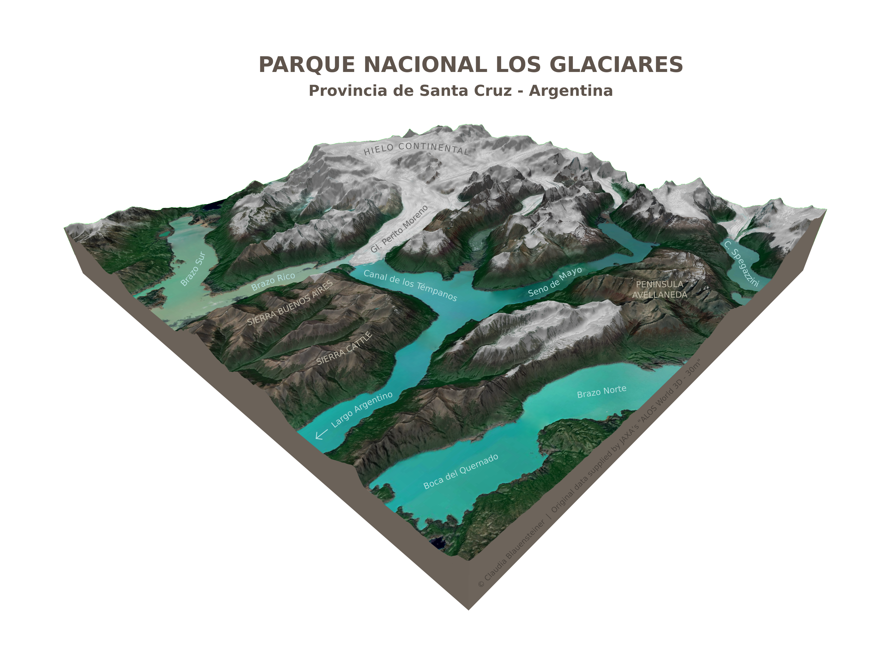
The La Leona River is a river of Patagonia, Argentina. It flows in the eastern part of the Los Glaciares National Park. It has its origin to the south of Lake Viedma and winds for about 50 kilometers (30 miles) through the Andes before flowing into Lake Argentino. See also *List of rivers of Argentina This is a list of rivers of Argentina. Longest Rivers By drainage basin This list is arranged by drainage basin, with respective tributaries indented under each larger stream's name. Rivers in the table above are in bold. La Plata Basin * RÃ ... References Rivers of Santa Cruz Province, Argentina Rivers of Argentina {{Argentina-river-stub ... [...More Info...] [...Related Items...] OR: [Wikipedia] [Google] [Baidu] |
Viedma Lake
Viedma Lake ( es, Lago Viedma, ) is a Patagonian lake in the province of Santa Cruz, Argentina, situated near its border with Chile. Measuring approximately 50 miles (80 kilometers) in length, it is a major elongated trough lake formed from melting glacial ice. Viedma Lake is the second largest perennial lake located entirely within Argentina."Principal Lagos de la Republica Argentina", http://www.ign.gob.ar/NuestrasActividades/Geografia/DatosArgentina/Lagos, accessed 20 Jul 2018. Note that this list does not include an area figure for the large but seasonal Mar Chiquita. The name of the lake comes from the Spanish explorer Antonio de Viedma, who in 1783 reached its shores, being the first European to do so. The town of El Chaltén and the Andes peaks Cerro Torre and Fitz-Roy lie in the proximity of Lake Viedma. Lake Viedma is fed primarily by the Viedma Glacier at its western end. The Viedma Glacier measures 3 miles (5 kilometers) wide at its terminus at Lake Viedma. The b ... [...More Info...] [...Related Items...] OR: [Wikipedia] [Google] [Baidu] |
Argentino Lake
Lago Argentino is a lake in the Patagonian province of Santa Cruz, Argentina, at . It is the biggest freshwater lake in Argentina, with a surface area of (maximum width: ). It has an average depth of , and a maximum depth of . The lake lies within the Los Glaciares National Park in a landscape with numerous glaciers and is fed by the glacial meltwater of several rivers, the water from Lake Viedma brought by the La Leona River, and many mountain streams. Its drainage basin amounts to more than . Waters from Lake Argentino flow into the Atlantic Ocean through the Santa Cruz River. The glaciers, the nearby town of El Calafate and the lake itself are important tourist destinations. The lake in particular is appreciated for fishing. Perch, common galaxias ("puyen grande"), lake trout and rainbow trout — in both anadromous and Potamodromous forms — are all found. ''Lago Argentino'' was also the name of the airport that served the area until 2000. This airport is currently clos ... [...More Info...] [...Related Items...] OR: [Wikipedia] [Google] [Baidu] |
Argentina
Argentina (), officially the Argentine Republic ( es, link=no, República Argentina), is a country in the southern half of South America. Argentina covers an area of , making it the second-largest country in South America after Brazil, the fourth-largest country in the Americas, and the eighth-largest country in the world. It shares the bulk of the Southern Cone with Chile to the west, and is also bordered by Bolivia and Paraguay to the north, Brazil to the northeast, Uruguay and the South Atlantic Ocean to the east, and the Drake Passage to the south. Argentina is a federal state subdivided into twenty-three provinces, and one autonomous city, which is the federal capital and largest city of the nation, Buenos Aires. The provinces and the capital have their own constitutions, but exist under a federal system. Argentina claims sovereignty over the Falkland Islands, South Georgia and the South Sandwich Islands, and a part of Antarctica. The earliest recorded human prese ... [...More Info...] [...Related Items...] OR: [Wikipedia] [Google] [Baidu] |
Patagonia
Patagonia () refers to a geographical region that encompasses the southern end of South America, governed by Argentina and Chile. The region comprises the southern section of the Andes Mountains with lakes, fjords, temperate rainforests, and glaciers in the west and deserts, tablelands and steppes to the east. Patagonia is bounded by the Pacific Ocean on the west, the Atlantic Ocean to the east, and many bodies of water that connect them, such as the Strait of Magellan, the Beagle Channel, and the Drake Passage to the south. The Colorado and Barrancas rivers, which run from the Andes to the Atlantic, are commonly considered the northern limit of Argentine Patagonia. The archipelago of Tierra del Fuego is sometimes included as part of Patagonia. Most geographers and historians locate the northern limit of Chilean Patagonia at Huincul Fault, in AraucanÃa Region.Manuel Enrique Schilling; Richard WalterCarlson; AndrésTassara; Rommulo Vieira Conceição; Gustavo Walter Bertotto; ... [...More Info...] [...Related Items...] OR: [Wikipedia] [Google] [Baidu] |
Los Glaciares National Park
Los Glaciares National Park ( es, Parque Nacional Los Glaciares) is a federal protected area in Santa Cruz Province, Argentina. The park covers an area of , making it the largest national park in the country. Established on 11 May 1937, it hosts a representative sample of Magellanic subpolar forest and west Patagonian steppe biodiversity in good state of conservation. In 1981, it was declared a World Heritage Site by UNESCO. The park's name refers to the giant ice cap in the Andes, the largest outside of Antarctica, Greenland and Iceland, feeding 47 large glaciers, of which 13 flow towards the Pacific Ocean. In other parts of the world, glaciers start at a height of at least above mean sea level, but due to the size of the ice cap, these glaciers begin at only , sliding down to . Los Glaciares borders Torres del Paine National Park to the south in Chilean territory. Geography Los Glaciares, of which 30% is covered by ice, can be divided in two parts, each corresponding wit ... [...More Info...] [...Related Items...] OR: [Wikipedia] [Google] [Baidu] |
Lake Viedma
Viedma Lake ( es, Lago Viedma, ) is a Patagonian lake in the province of Santa Cruz, Argentina, situated near its border with Chile. Measuring approximately 50 miles (80 kilometers) in length, it is a major elongated trough lake formed from melting glacial ice. Viedma Lake is the second largest perennial lake located entirely within Argentina."Principal Lagos de la Republica Argentina", http://www.ign.gob.ar/NuestrasActividades/Geografia/DatosArgentina/Lagos, accessed 20 Jul 2018. Note that this list does not include an area figure for the large but seasonal Mar Chiquita. The name of the lake comes from the Spanish explorer Antonio de Viedma, who in 1783 reached its shores, being the first European to do so. The town of El Chaltén and the Andes peaks Cerro Torre and Fitz-Roy lie in the proximity of Lake Viedma. Lake Viedma is fed primarily by the Viedma Glacier at its western end. The Viedma Glacier measures 3 miles (5 kilometers) wide at its terminus at Lake Viedma. The bro ... [...More Info...] [...Related Items...] OR: [Wikipedia] [Google] [Baidu] |
Andes
The Andes, Andes Mountains or Andean Mountains (; ) are the longest continental mountain range in the world, forming a continuous highland along the western edge of South America. The range is long, wide (widest between 18°S – 20°S latitude), and has an average height of about . The Andes extend from north to south through seven South American countries: Venezuela, Colombia, Ecuador, Peru, Bolivia, Chile, and Argentina. Along their length, the Andes are split into several ranges, separated by intermediate depressions. The Andes are the location of several high plateaus—some of which host major cities such as Quito, Bogotá, Cali, Arequipa, MedellÃn, Bucaramanga, Sucre, Mérida, El Alto and La Paz. The Altiplano plateau is the world's second-highest after the Tibetan plateau. These ranges are in turn grouped into three major divisions based on climate: the Tropical Andes, the Dry Andes, and the Wet Andes. The Andes Mountains are the highest m ... [...More Info...] [...Related Items...] OR: [Wikipedia] [Google] [Baidu] |
Lake Argentino
Lago Argentino is a lake in the Patagonian province of Santa Cruz, Argentina, at . It is the biggest freshwater lake in Argentina, with a surface area of (maximum width: ). It has an average depth of , and a maximum depth of . The lake lies within the Los Glaciares National Park in a landscape with numerous glaciers and is fed by the glacial meltwater of several rivers, the water from Lake Viedma brought by the La Leona River, and many mountain streams. Its drainage basin amounts to more than . Waters from Lake Argentino flow into the Atlantic Ocean through the Santa Cruz River. The glaciers, the nearby town of El Calafate and the lake itself are important tourist destinations. The lake in particular is appreciated for fishing. Perch, common galaxias ("puyen grande"), lake trout and rainbow trout — in both anadromous and Potamodromous forms — are all found. ''Lago Argentino'' was also the name of the airport that served the area until 2000. This airport is currently closed ... [...More Info...] [...Related Items...] OR: [Wikipedia] [Google] [Baidu] |
List Of Rivers Of Argentina
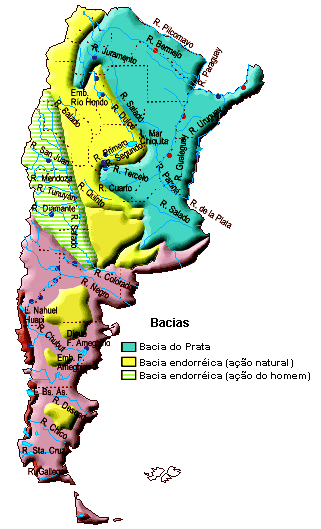
This is a list of rivers of Argentina. Longest Rivers By drainage basin This list is arranged by drainage basin, with respective tributaries indented under each larger stream's name. Rivers in the table above are in bold. La Plata Basin * RÃo de la Plata ** Uruguay River *** Gualeguaychú River *** Mocoretá River *** Miriñay River *** Aguapey River *** Pepiri-Guazu River ** Paraná River *** Arrecifes River *** Gualeguay River *** Nogoyá River *** Arroyo del Medio *** Saladillo Stream *** Ludueña Stream *** Carcarañá River **** Tercero River (Calamuchita River) **** Cuarto River (Saladillo River, Chocancharava River) *** Salado River (Salado del Norte, Juramento River, Pasaje River, Calchaquà River) **** Horcones River ***** Urueña River **** Arenales River **** Rosario River **** Guasamayo River *** San Javier River *** Feliciano River *** Guayquiraró River *** Corriente River *** Paraná Minà River **** Tapenagá River **** Palometa River *** Santa LucÃa ... [...More Info...] [...Related Items...] OR: [Wikipedia] [Google] [Baidu] |
Rivers Of Santa Cruz Province, Argentina
A river is a natural flowing watercourse, usually freshwater, flowing towards an ocean, sea, lake or another river. In some cases, a river flows into the ground and becomes dry at the end of its course without reaching another body of water. Small rivers can be referred to using names such as creek, brook, rivulet, and rill. There are no official definitions for the generic term river as applied to geographic features, although in some countries or communities a stream is defined by its size. Many names for small rivers are specific to geographic location; examples are "run" in some parts of the United States, "burn" in Scotland and northeast England, and "beck" in northern England. Sometimes a river is defined as being larger than a creek, but not always: the language is vague. Rivers are part of the water cycle. Water generally collects in a river from precipitation through a drainage basin from surface runoff and other sources such as groundwater recharge, springs, a ... [...More Info...] [...Related Items...] OR: [Wikipedia] [Google] [Baidu] |
.jpg)


.jpg)

