|
Lopo Homem
Lopo Homem (c. 1497 - c. 1572) was a 16th-century Portuguese cartographer and cosmographer based in Lisbon and best known for his work on the Miller Atlas. Biography Homem is estimated to have been born c. 1497, possibly into a noble family. He is known to have spent time in Azamor between 1520 and 1522 and in Lisbon in 1565. Beginning in 1517, he served as the crown's official cartographer and was given exclusive rights to "constructing and correcting... nautical compasses." If anyone else attempted to calibrate a ship, they were required to pay Homem, the Master of Nautical Instruments, 20 cruzados. These rights and titles were renewed in 1524 by King João III of Portugal. In 1524, Homem was involved in preliminary negotiations on behalf of the Portuguese crown as an expert witness at the Conferences of Badajoz-Elvas, which aimed to settle a dispute with Castile for the Molucca Islands. For this, he was given a pension of 1200 reais. A letter written by Lopo Homem alludi ... [...More Info...] [...Related Items...] OR: [Wikipedia] [Google] [Baidu] |
Cartographer
Cartography (; from grc, χάρτης , "papyrus, sheet of paper, map"; and , "write") is the study and practice of making and using maps. Combining science, aesthetics and technique, cartography builds on the premise that reality (or an imagined reality) can be modeled in ways that communicate spatial information effectively. The fundamental objectives of traditional cartography are to: * Set the map's agenda and select traits of the object to be mapped. This is the concern of map editing. Traits may be physical, such as roads or land masses, or may be abstract, such as Toponomy, toponyms or political boundaries. * Represent the terrain of the mapped object on flat media. This is the concern of map projections. * Eliminate characteristics of the mapped object that are not relevant to the map's purpose. This is the concern of Cartographic generalization, generalization. * Reduce the complexity of the characteristics that will be mapped. This is also the concern of generaliza ... [...More Info...] [...Related Items...] OR: [Wikipedia] [Google] [Baidu] |
Ptolemy
Claudius Ptolemy (; grc-gre, Πτολεμαῖος, ; la, Claudius Ptolemaeus; AD) was a mathematician, astronomer, astrologer, geographer, and music theorist, who wrote about a dozen scientific treatises, three of which were of importance to later Byzantine, Islamic, and Western European science. The first is the astronomical treatise now known as the '' Almagest'', although it was originally entitled the ''Mathēmatikē Syntaxis'' or ''Mathematical Treatise'', and later known as ''The Greatest Treatise''. The second is the ''Geography'', which is a thorough discussion on maps and the geographic knowledge of the Greco-Roman world. The third is the astrological treatise in which he attempted to adapt horoscopic astrology to the Aristotelian natural philosophy of his day. This is sometimes known as the ''Apotelesmatika'' (lit. "On the Effects") but more commonly known as the '' Tetrábiblos'', from the Koine Greek meaning "Four Books", or by its Latin equivalent ''Quadrip ... [...More Info...] [...Related Items...] OR: [Wikipedia] [Google] [Baidu] |
Indigenous Peoples In Brazil
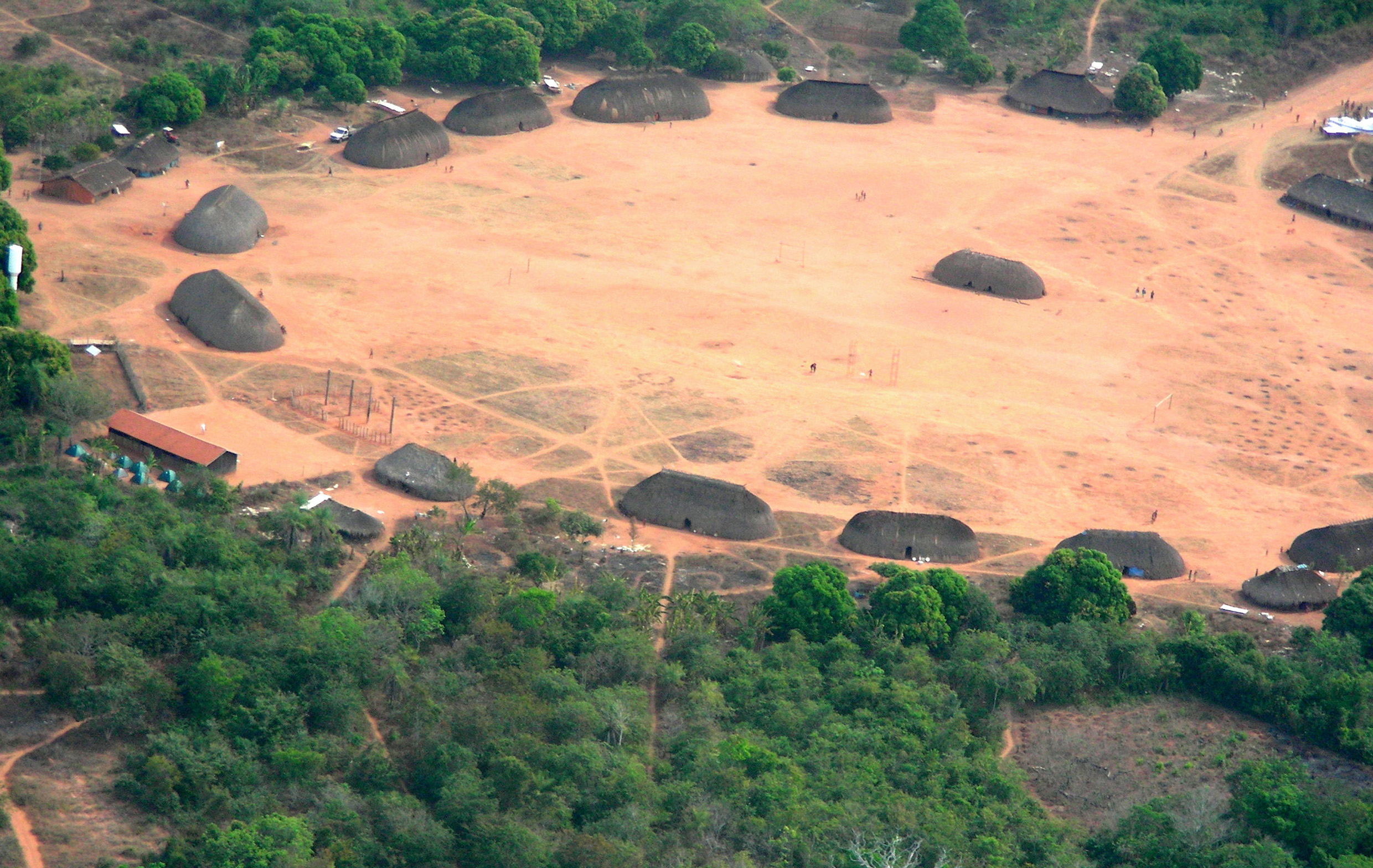
Indigenous peoples in Brazil ( pt, povos indígenas no Brasil) or Indigenous Brazilians ( pt, indígenas brasileiros, links=no) once comprised an estimated 2000 tribes and nations inhabiting what is now the country of Brazil, before European contact around 1500. Christopher Columbus thought he had reached the East Indies, but Portuguese Vasco da Gama had already reached India via the Indian Ocean route, when Brazil was colonized by Portugal. Nevertheless, the word ("Indians") was by then established to designate the people of the New World and continues to be used in the Portuguese language to designate these people, while a person from India is called in order to distinguish the two. At the time of European contact, some of the Indigenous people were traditionally semi-nomadic tribes who subsisted on hunting, fishing, gathering and migrant agriculture. Many tribes suffered extinction as a consequence of the European settlement and many were assimilated into the Brazilian po ... [...More Info...] [...Related Items...] OR: [Wikipedia] [Google] [Baidu] |
National Library Of France
National may refer to: Common uses * Nation or country ** Nationality – a ''national'' is a person who is subject to a nation, regardless of whether the person has full rights as a citizen Places in the United States * National, Maryland, census-designated place * National, Nevada, ghost town * National, Utah, ghost town * National, West Virginia, unincorporated community Commerce * National (brand), a brand name of electronic goods from Panasonic * National Benzole (or simply known as National), former petrol station chain in the UK, merged with BP * National Car Rental, an American rental car company * National Energy Systems, a former name of Eco Marine Power * National Entertainment Commission, a former name of the Media Rating Council * National Motor Vehicle Company, Indianapolis, Indiana, USA 1900-1924 * National Supermarkets, a defunct American grocery store chain * National String Instrument Corporation, a guitar company formed to manufacture the first resonator gu ... [...More Info...] [...Related Items...] OR: [Wikipedia] [Google] [Baidu] |
Kujata
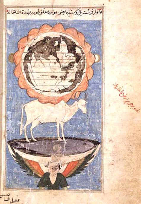
Kuyūthā ( ar, كيوثاء) is the cosmic bull in medieval Islamic cosmography. It is said to carry on its back the angel who shoulders the earth and the rock platform upon which the angel stands. The bull is said to stand on the giant fish or whale, Bahamut. The bull is variously described as having 40,000 horns and legs, or as many eyes, ears, mouths and tongues in the oldest sources. The number of appendages can vary in later versions. Its breathing is said to control the tides of the ocean. Kīyūbān ( ar, کیوبان) or Kibūthān ( ar, کبوثان) also appear in printed editions of Qazwini's cosmography. These have been claimed to be corruptions of Leviathan ( ar, لوياتان). Alternate names include Al-Rayann. Kuyootà, Kuyoothán were forms of the name as transcribed by Edward Lane, and given as Kuyata (Spanish), Kujata (first English translation, 1969), and Quyata (revised English translation) in various editions of Jorge Luis Borges's ''Book of Imaginary B ... [...More Info...] [...Related Items...] OR: [Wikipedia] [Google] [Baidu] |
Duarte Pacheco Pereira
Duarte Pacheco Pereira (; c. 1460 – 1533), called the Portuguese Achilles (''Aquiles Lusitano'') by the poet Camões, was a Portuguese sea captain, soldier, explorer and cartographer. He travelled particularly in the central Atlantic Ocean west of the Cape Verde islands, along the coast of West Africa and to India. His accomplishments in strategic warfare, exploration, mathematics and astronomy were of an exceptional level. Background Pacheco Pereira was the son of João Pacheco and Isabel Pereira. In his youth he served as the King of Portugal's personal squire. In the year of 1475, having graduated with honors, he was awarded a study fellowship from the monarch himself. Later on, in 1488 he explored the west coast of Africa. His expedition fell ill with fever and lost their ship. Pacheco Pereira was rescued from the island of Príncipe in the Gulf of Guinea by Bartolomeu Dias when Dias was returning from rounding the Cape of Good Hope for the first time. The knowledge he ... [...More Info...] [...Related Items...] OR: [Wikipedia] [Google] [Baidu] |
Vasco Da Gama
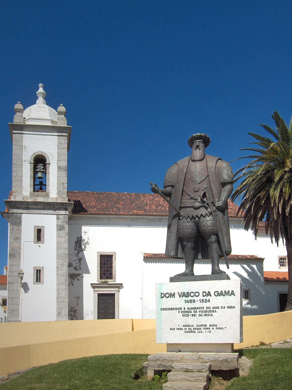
Vasco da Gama, 1st Count of Vidigueira (; ; c. 1460s – 24 December 1524), was a Portuguese explorer and the first European to reach India by sea. His initial voyage to India by way of Cape of Good Hope (1497–1499) was the first to link Europe and Asia by an ocean route, connecting the Atlantic and the Indian oceans. This is widely considered a milestone in world history, as it marked the beginning of a sea-based phase of global multiculturalism. Da Gama's discovery of the sea route to India opened the way for an age of global imperialism and enabled the Portuguese to establish a long-lasting colonial empire along the way from Africa to Asia. The violence and hostage-taking employed by da Gama and those who followed also assigned a brutal reputation to the Portuguese among India's indigenous kingdoms that would set the pattern for western colonialism in the Age of Exploration. Traveling the ocean route allowed the Portuguese to avoid sailing across the highly disputed Medit ... [...More Info...] [...Related Items...] OR: [Wikipedia] [Google] [Baidu] |
Bartolomeu Dias
Bartolomeu Dias ( 1450 – 29 May 1500) was a Portuguese mariner and explorer. In 1488, he became the first European navigator to round the southern tip of Africa and to demonstrate that the most effective southward route for ships lay in the open ocean, well to the west of the African coast. His discoveries effectively established the sea route between Europe and Asia. Early life Bartholomeu Dias was born around 1455. His family had a maritime background and one of his ancestors, Dinis Dias, explored the African coast in the 1440s and discovered the Cape Verde Peninsula in 1445. Little is known of his early life, and tracing his biography is complicated by the existence of several contemporary Portuguese seafarers with the same name. He was clearly a seaman of considerable experience and may have been trading for ivory along the Guinea coast as early as 1478. In 1481, Dias accompanied an expedition, led by Diogo de Azambuja, to construct a fortress and trading post called S� ... [...More Info...] [...Related Items...] OR: [Wikipedia] [Google] [Baidu] |
Sinus Magnus
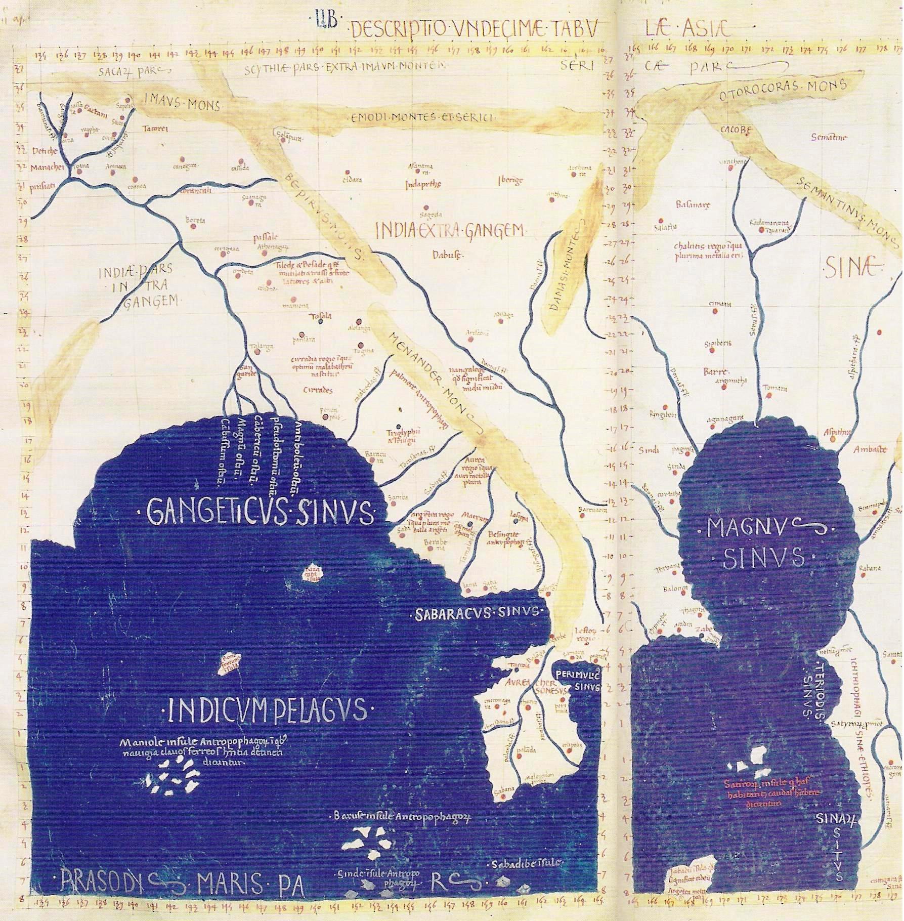
The Magnus Sinus or Sinus Magnus (Latin; grc-gre, ὀ Μέγας Κόλπος, ''o Mégas Kólpos''), also anglicization of names, anglicized as the was the form of the Gulf of Thailand and South China Sea known to Greek geographers, Greek, Roman geographers, Roman, medieval Arab geographers, Arab, medieval Persian geographers, Persian, and Renaissance cartographers before the Age of Discovery. It was then briefly conflated with the Pacific Ocean before disappearing from maps. History The gulf and its major port of Cattigara had supposedly been reached by a 1st-century Ancient Greeks, Greek trader named Alexander, who returned safely and left a periplus of his voyage. His account that Cattigara was "some days" sail from Zaba (Ptolemy), Zaba was taken by Marinus of Tyre, Marinus of Tyre (city), Tyre to mean "numberless" days and by Ptolemy to mean "a few". Both Alexander and Marinus's works have been lost, but were claimed as authorities by Ptolemy in Ptolemy's Geography, his ''G ... [...More Info...] [...Related Items...] OR: [Wikipedia] [Google] [Baidu] |
Malay Peninsula
The Malay Peninsula (Malay: ''Semenanjung Tanah Melayu'') is a peninsula in Mainland Southeast Asia. The landmass runs approximately north–south, and at its terminus, it is the southernmost point of the Asian continental mainland. The area contains Peninsular Malaysia, Southern Thailand, and the southernmost tip of Myanmar (Kawthaung). The island country of Singapore also has historical and cultural ties with the region. The indigenous people of the peninsula are the Malays, an Austronesian people. The Titiwangsa Mountains are part of the Tenasserim Hills system and form the backbone of the peninsula and the southernmost section of the central cordillera, which runs from Tibet through the Kra Isthmus, the peninsula's narrowest point, into the Malay Peninsula. The Strait of Malacca separates the Malay Peninsula from the Indonesian island of Sumatra, and the south coast is separated from the island of Singapore by the Straits of Johor. Etymology The Malay term ''Tanah Me ... [...More Info...] [...Related Items...] OR: [Wikipedia] [Google] [Baidu] |
Claudius Ptolemy
Claudius Ptolemy (; grc-gre, Πτολεμαῖος, ; la, Claudius Ptolemaeus; AD) was a mathematician, astronomer, astrologer, geographer, and music theorist, who wrote about a dozen scientific treatises, three of which were of importance to later Byzantine, Islamic, and Western European science. The first is the astronomical treatise now known as the '' Almagest'', although it was originally entitled the ''Mathēmatikē Syntaxis'' or ''Mathematical Treatise'', and later known as ''The Greatest Treatise''. The second is the ''Geography'', which is a thorough discussion on maps and the geographic knowledge of the Greco-Roman world. The third is the astrological treatise in which he attempted to adapt horoscopic astrology to the Aristotelian natural philosophy of his day. This is sometimes known as the ''Apotelesmatika'' (lit. "On the Effects") but more commonly known as the '' Tetrábiblos'', from the Koine Greek meaning "Four Books", or by its Latin equivalent ''Quadripart ... [...More Info...] [...Related Items...] OR: [Wikipedia] [Google] [Baidu] |


