|
Long Grass Quarry
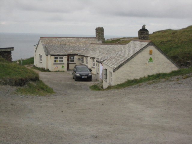
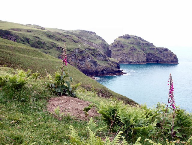
Long Grass Quarry (also known as Cliff Quarry) is a small, disused slate quarry between Tintagel and Trebarwith on the north coast of Cornwall, South West England, which was worked up until 1937. It was the last of the slate quarries on this stretch of coast to be abandoned. Location The quarry site occupies the stretch of coastline immediately north west of the Tintagel youth hostel and just to the south of the abandoned Gillow Slate Quarry. The quarry workings extend for around 70m in length and reach a height of 59m. Quarrying Men would use flights of wooden ladders to climb down the sheer rock face to the left of a small "box cave" that had been tunnelled at the foot of the cliff. Quarrying here was hazardous: in 1886, three workers lost their lives when the rock they were drilling fell into the sea and a quarryman named Reuben Tinney died in 1936 shortly before the quarry closed.Booklet: ”The National Trust Coast of Cornwall: 4 Tintagel”, Brian Le Messurier, 1991 Ind ... [...More Info...] [...Related Items...] OR: [Wikipedia] [Google] [Baidu] |
Tintagel
Tintagel () or Trevena ( kw, Tre war Venydh, meaning ''Village on a Mountain'') is a civil parish and village situated on the Atlantic coast of Cornwall, England. The village and nearby Tintagel Castle are associated with the legends surrounding King Arthur and in recent times has become a tourist attraction. Toponymy Toponymists have had difficulty explaining the origin of 'Tintagel': the probability is that it is Norman French, as the Cornish of the 13th century would have lacked the soft 'g' ('i/j' in the earliest forms: see also Tintagel Castle). If it is Cornish then 'Dun' would mean ''Fort''. Oliver Padel proposes 'Dun' '-tagell' meaning ''narrow place'' in his book on place names. There is a possible cognate in the Channel Islands named ''Tente d'Agel'', but that still leaves the question subject to doubt. The name first occurs in Geoffrey of Monmouth's ''Historia Regum Britanniae'' (c. 1136, in Latin) as ''Tintagol'', implying pronunciation with a hard sound as in ... [...More Info...] [...Related Items...] OR: [Wikipedia] [Google] [Baidu] |
Trebarwith
Trebarwith ( kw, Treberveth, meaning ''middle/inner farm''), known locally as Trebarwith Village, is a hamlet in the parish of Tintagel, Cornwall, England, United Kingdom. Trebarwith Strand Trebarwith Strand ( kw, Trebervedh Sian; locally sometimes shortened to ''The Strand'') is a section of coastline located near the coastal settlement of Trebarwith on the north coast of Cornwall, England, UK, south of Tintagel. It has 800m of san ... is on the coast nearby. Land at Trebarwith is first mentioned in records of 1284 and was held from 1329 until the early 16th century by the Lercedekne family. Trebarwith Farm is a Grade II listed building. References category:Tintagel Hamlets in Cornwall {{Cornwall-geo-stub ... [...More Info...] [...Related Items...] OR: [Wikipedia] [Google] [Baidu] |
Cornwall
Cornwall (; kw, Kernow ) is a historic county and ceremonial county in South West England. It is recognised as one of the Celtic nations, and is the homeland of the Cornish people. Cornwall is bordered to the north and west by the Atlantic Ocean, to the south by the English Channel, and to the east by the county of Devon, with the River Tamar forming the border between them. Cornwall forms the westernmost part of the South West Peninsula of the island of Great Britain. The southwesternmost point is Land's End and the southernmost Lizard Point. Cornwall has a population of and an area of . The county has been administered since 2009 by the unitary authority, Cornwall Council. The ceremonial county of Cornwall also includes the Isles of Scilly, which are administered separately. The administrative centre of Cornwall is Truro, its only city. Cornwall was formerly a Brythonic kingdom and subsequently a royal duchy. It is the cultural and ethnic origin of the Cornish dias ... [...More Info...] [...Related Items...] OR: [Wikipedia] [Google] [Baidu] |
South West England
South West England, or the South West of England, is one of nine official regions of England. It consists of the counties of Bristol, Cornwall (including the Isles of Scilly), Dorset, Devon, Gloucestershire, Somerset and Wiltshire. Cities and large towns in the region include Bath, Somerset, Bath, Bristol, Bournemouth, Cheltenham, Exeter, Gloucester, Plymouth and Swindon. It is geographically the largest of the nine regions of England covering , but the third-least populous, with approximately five million residents. The region includes the West Country and much of the ancient kingdom of Wessex. It includes two entire national parks of England and Wales, national parks, Dartmoor and Exmoor (a small part of the New Forest is also within the region); and four List of World Heritage Sites in the United Kingdom, World Heritage Sites: Stonehenge, the Cornwall and West Devon Mining Landscape, the Jurassic Coast and the Bath, Somerset, City of Bath. The northern part of Gloucestershi ... [...More Info...] [...Related Items...] OR: [Wikipedia] [Google] [Baidu] |
Youth Hostel
A hostel is a form of low-cost, short-term shared sociable lodging where guests can rent a bed, usually a bunk bed in a dormitory, with shared use of a lounge and sometimes a kitchen. Rooms can be mixed or single-sex and have private or shared bathrooms. Private rooms may also be available, but the property must offer dormitories to be considered a hostel. Hostels are popular forms of lodging for backpackers. They are part of the sharing economy. Benefits of hostels include lower costs and opportunities to meet people from different places, find travel partners, and share travel ideas. Some hostels, such as Zostel in India or Hostelling International, cater to a niche market of travelers. For example, one hostel might feature in-house social gatherings such as movie nights or communal dinners, another might feature local tours, one might be known for its parties, and another might have a quieter place to relax in serenity, or be located on the beach. Newer hostels focus on a more ... [...More Info...] [...Related Items...] OR: [Wikipedia] [Google] [Baidu] |
Gillow Slate Quarry
Gillow State Quarry is a small, disused slate quarry between Tintagel and Trebarwith on the north coast of Cornwall, South West England. The quarry was abandoned by the turn of the 20th century. Location The quarry site is at the foot of a steep coastal slope just north of St Materiana's Church in Tintagel and just to the west of the South West Coast Path. The quarry workings extend from sea level around 40m to the top of the cliff. The terracing where the slate has been worked can still be seen, as well as some platforms for whims and the remains of what might have been tool sheds.«Coastal Slate Quarries – Tintagel to Trebarwith” (1990) Adam Sharpe, CAU archaeological survey for the National Trust. ISBN 1 871162 95 5 Gillow Quarry is just north of Long Grass Quarry Long Grass Quarry (also known as Cliff Quarry) is a small, disused slate quarry between Tintagel and Trebarwith on the north coast of Cornwall, South West England, which was worked up until 1937. It was ... [...More Info...] [...Related Items...] OR: [Wikipedia] [Google] [Baidu] |
Lambshouse And Gull Point Quarry
Lambshouse and Gull Point Quarries are two disused slate quarries between Tintagel and Trebarwith at Lambshouse Cove on the north coast of Cornwall, South West England. The quarries were latterly worked jointly as one site and were abandoned by the turn of the 20th century. It is likely that Lambshouse Quarry originated at the cliffs at the north of the cove while Gull Point was to the south. Location The quarry site cuts a deep "D" shape into the cliffs immediately due south of the Tintagel youth hostel building and is known as Lambshouse Cove. The near vertical cliffs around the cove are almost entirely artificial and the workihgs of drills can be seen in the rock wall.«Coastal Slate Quarries – Tintagel to Trebarwith” (1990) Adam Sharpe, CAU archaeological survey for the National Trust. ISBN 1 871162 95 5 The quarries are just south of Long Grass Quarry and just north of Dria Quarry. Stone The quarry provided a source of Upper Devonian slate and Lower Carboniferous ... [...More Info...] [...Related Items...] OR: [Wikipedia] [Google] [Baidu] |
Upper Devonian
The Devonian ( ) is a geologic period and system of the Paleozoic era, spanning 60.3 million years from the end of the Silurian, million years ago (Mya), to the beginning of the Carboniferous, Mya. It is named after Devon, England, where rocks from this period were first studied. The first significant adaptive radiation of life on dry land occurred during the Devonian. Free-sporing vascular plants began to spread across dry land, forming extensive forests which covered the continents. By the middle of the Devonian, several groups of plants had evolved leaves and true roots, and by the end of the period the first seed-bearing plants appeared. The arthropod groups of myriapods, arachnids and hexapods also became well-established early in this period, after starting their expansion to land at least from the Ordovician period. Fish reached substantial diversity during this time, leading the Devonian to often be dubbed the Age of Fishes. The placoderms began dominating al ... [...More Info...] [...Related Items...] OR: [Wikipedia] [Google] [Baidu] |
Lower Carboniferous
Lower may refer to: *Lower (surname) *Lower Township, New Jersey *Lower Receiver (firearms) *Lower Wick Lower Wick is a small hamlet located in the county of Gloucestershire, England. It is situated about five miles south west of Dursley, eighteen miles southwest of Gloucester and fifteen miles northeast of Bristol. Lower Wick is within the civil ... Gloucestershire, England See also * Nizhny {{Disambiguation ... [...More Info...] [...Related Items...] OR: [Wikipedia] [Google] [Baidu] |
Iota (Italian Ship)
Iota was a wooden barque built in Bideford in 1866 and weighing 572 tons. The ship was owned by an Italian firm named Mazella based in Naples and was wrecked near Tintagel, Cornwall, on 20 December 1893. The wreck The Iota was en route from Cardiff to Trinidad with a cargo of coal. The ship was driven against Lye Rock in a storm at around 5pm by which time it was already dark. Onlookers at nearby Willapark watched helplessly as mountainous waves pounded the boat. The rescue The eleven Italian crew and one boy attempted to either swim to shore or climb from one of the ship's masts to the pinnacle of Lye Rock. One of the sailors tried to help the fourteen-year-old boy, Domenico Catanese to shore but both drowned. Two crew made it onto Lye Rock but it was clear that they would not make it to safety without help. Three local men led by Thomas Brown were joined by a coastguard and once the tide was low enough, they battled wind, waves and darkness to climb Lye Rock. Not underst ... [...More Info...] [...Related Items...] OR: [Wikipedia] [Google] [Baidu] |
Lye Cove
Lye Cove is a small coastal inlet near Tintagel on the north coast of Cornwall, South West England. The cove lies immediately below the Iron Age hill fort known as Willapark and nearby Lye Rock was the site of the wreck of the Italian cargo ship Iota in 1893. Above the cove is the remains of a nineteenth century lime kiln. Wreck of the Iota The Iota was an Italian barque bound for Trinidad from Cardiff with a cargo of Welsh coal. On 20 December 1893, a fierce storm drove the ship onto Lye Rock. A heroic four-man rescue team led by local quarryman, Charles Hambly was able to save eleven of the twelve crew. 14-year-old Domenico Catanese drowned and is buried in nearby St Materiana’s churchyard. The crew were able to get onto the rock and apart from Catanese were saved (the name is given in the official Italian usage, surname first: Catanese Domenico, on a lifebuoy). Seabird colony Lye Rock is a breeding site for guillemots, razorbills, fulmars and shags. By 1940, the rock was ... [...More Info...] [...Related Items...] OR: [Wikipedia] [Google] [Baidu] |
Breeches Buoy
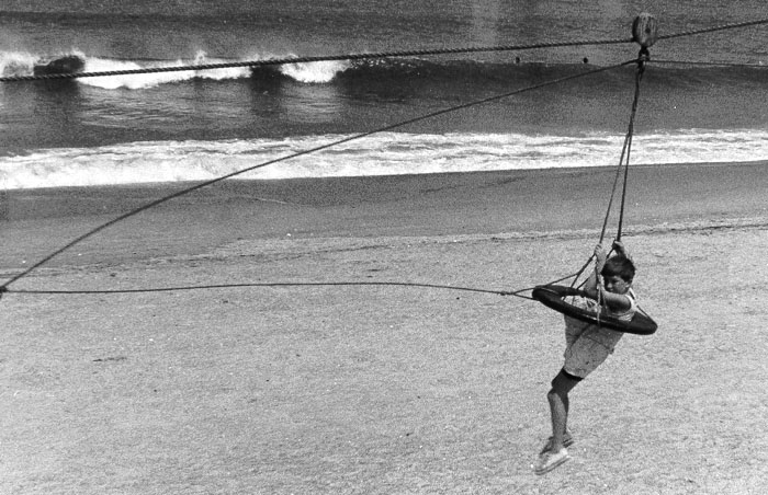
A breeches buoy is a rope-based rescue device used to extract people from wrecked vessels, or to transfer people from one place to another in situations of danger. The device resembles a round emergency personal flotation device with a leg harness attached. It is similar to a zip line. The breeches buoy may be deployed from shore to ship, ship to ship, or ship to shore using a Manby mortar, rocket, kite system, or a Lyle gun, and allowed evacuations of one person at a time. A line is attached to the ship, and the person being rescued is pulled to shore in the breeches buoy. History An early rescue using the equipment took place in 1866. The correspondent of the Scotsman, wrote :— Described as the first use of the apparatus, a re-enactment took place 150 years later. Eventually the Manby mortar was replaced by rockets to shoot lines to ships in distress. In 1967 a documentary on the inventor George Manby was made. Locations included Denver, Downham Market and Great Y ... [...More Info...] [...Related Items...] OR: [Wikipedia] [Google] [Baidu] |
_(9458675814).jpg)


