|
List Of Spits
There are many examples of spits around the world. Some of which include: By sea Azov Sea ;Russia * Achuevsk Spit * Beglitsk Spit * Chushka Spit * Dolgaya Spit * Glafirovsk Spit * Kamyshevatsk Spit * Petrushino Spit * Sazalniksk Spit * Yasensk Spit * Yeysk Spit ;Ukraine * Belosaraysk Spit * Berdyansk Spit * Fedotova Spit * Krivaya Spit * Obytichna Spit ; Crimea (disputed between Russia and Ukraine) * Arabat Spit * Tuzla Spit Baltic Sea * Curonian Spit, Russia/ Lithuania * Hel Spit, Poland * Priwall, Germany * Vistula Spit, Poland/Russia Skagerrak * Grenen, Denmark By country Australia *Lefevre Peninsula, Adelaide, South Australia * Letitia Spit, Fingal Head, New South Wales * Southport Spit, Gold Coast, Queensland * Tobias Spit, 1 km northeast of High Island, Frankland Islands, Queensland Brunei * Seri Kenangan Beach, Pekan Tutong, Tutong * Pelumpong Spit, Serasa, Brunei-Muara * Serasa Beach, Serasa, Brunei-Muara Canada *Toronto Islands (former s ... [...More Info...] [...Related Items...] OR: [Wikipedia] [Google] [Baidu] |
Spit (landform)
A spit or sandspit is a deposition bar or beach landform off coasts or lake shores. It develops in places where re-entrance occurs, such as at a cove's headlands, by the process of longshore drift by longshore currents. The drift occurs due to waves meeting the beach at an oblique angle, moving sediment down the beach in a zigzag pattern. This is complemented by longshore currents, which further transport sediment through the water alongside the beach. These currents are caused by the same waves that cause the drift. Hydrology and geology Where the direction of the shore inland ''re-enters'', or changes direction, for example at a headland, the longshore current spreads out or dissipates. No longer able to carry the full load, much of the sediment is dropped. This is called deposition. This submerged bar of sediment allows longshore drift or littoral drift to continue to transport sediment in the direction the waves are breaking, forming an above-water spit. Without the co ... [...More Info...] [...Related Items...] OR: [Wikipedia] [Google] [Baidu] |
Lefevre Peninsula
The Lefevre Peninsula is a peninsula located in the Australian state of South Australia located about northwest of the Adelaide city centre. It is a narrow sand spit of about running north from its connection to the mainland. The name given to the peninsula by the traditional owners of the area, the Kaurna people, was Mudlangga, meaning "nose-place" in the Kaurna language. Location and extent Lefevre Peninsula, with a population of approximately 30,000 residents, is located on the east coast of Gulf St Vincent about north-west of the Adelaide city centre. The peninsula is bounded to the west by Gulf St Vincent and to the north and the east by the Port River. The southern boundary of the “topographical peninsula” has been determined by the Surveyor General of South Australia as being Recreation Road in the suburb of Semaphore Park as “an examination of old plans indicate that boats could have navigated the Port Adelaide River to approximately this point”. Descriptio ... [...More Info...] [...Related Items...] OR: [Wikipedia] [Google] [Baidu] |
Denmark
) , song = ( en, "King Christian stood by the lofty mast") , song_type = National and royal anthem , image_map = EU-Denmark.svg , map_caption = , subdivision_type = Sovereign state , subdivision_name = Danish Realm, Kingdom of Denmark , established_title = History of Denmark#Middle ages, Consolidation , established_date = 8th century , established_title2 = Christianization , established_date2 = 965 , established_title3 = , established_date3 = 5 June 1849 , established_title4 = Faroese home rule , established_date4 = 24 March 1948 , established_title5 = European Economic Community, EEC 1973 enlargement of the European Communities, accession , established_date5 = 1 January 1973 , established_title6 = Greenlandic home rule , established_date6 = 1 May 1979 , official_languages = Danish language, Danish , languages_type = Regional languages , languages_sub = yes , languages = German language, GermanGerman is recognised as a protected minority language in t ... [...More Info...] [...Related Items...] OR: [Wikipedia] [Google] [Baidu] |
Grenen
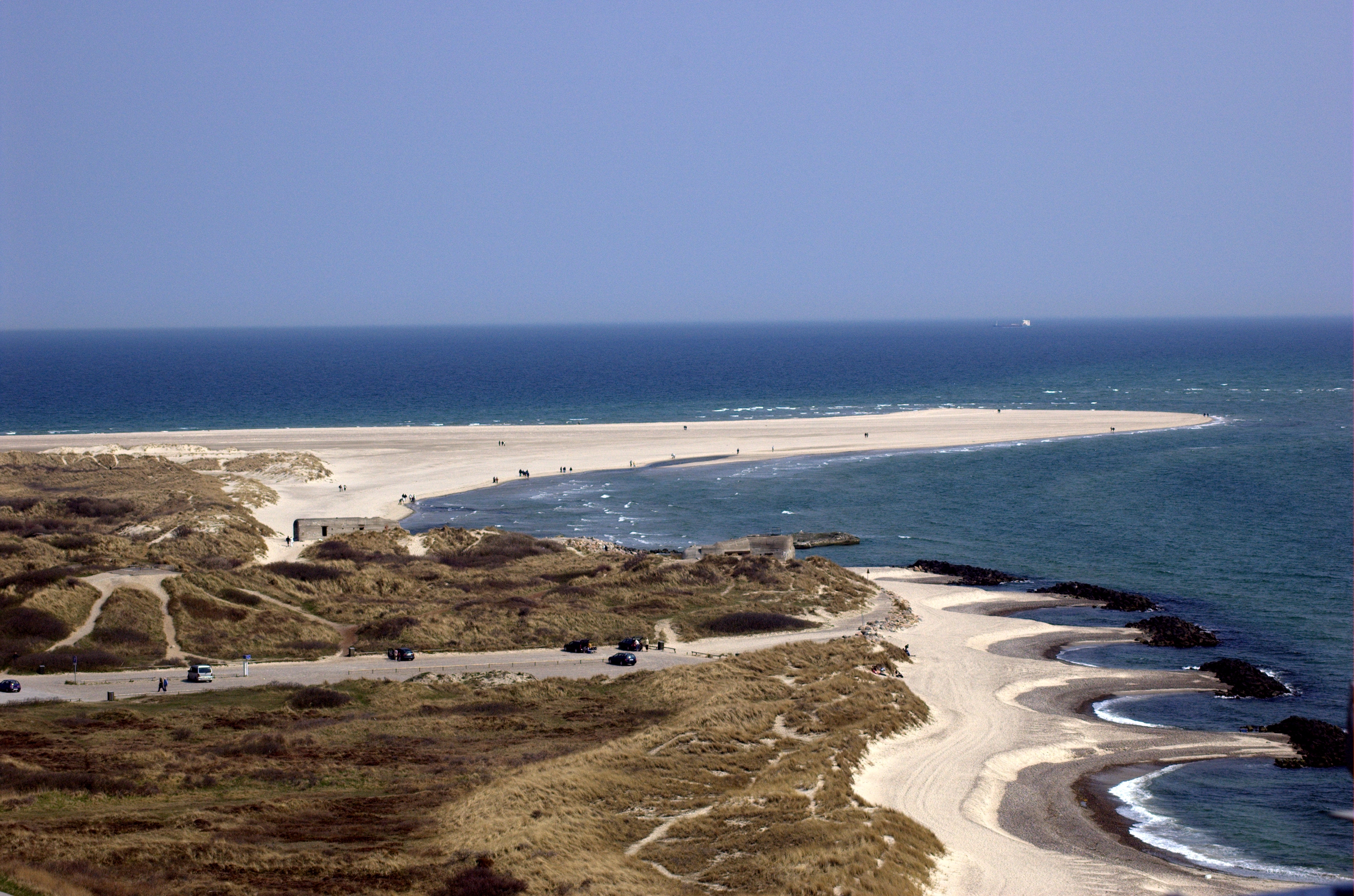
Grenen is a long sandbar spit at Skagen Odde (the headland of Jutland), north of the town of Skagen. Overview ''Grenen'' (The Branch) was named for its shape like a tree-branch, reaching out from the mainland. The beach of Grenen appears in many of the works of the Skagen Painters, a community that gathered there every summer between 1875 and the end of the 19th century. The area is also home to the Skagen Odde Nature Centre, designed by Jørn Utzon. Near the tip of the spit are two small museums: Skagen Bunker Museum and Grenens Kunstmuseum. Danish national road 40 terminates at Grenen, and it is one of the most popular tourist destinations in the country, with approximately 2 million visitors each year. Nature Grenen marks the junction between the strait of Skagerrak (part of the North Sea) and the Kattegat sea, and the turbulent colliding seas have created a 4-km long curved sandbar above and below the waves stretching east. The reef is still active and has grown about 1 ... [...More Info...] [...Related Items...] OR: [Wikipedia] [Google] [Baidu] |
Vistula Spit
The Vistula Spit ( pl, Mierzeja Wiślana; russian: Балтийская коса; german: Frische Nehrung) is an aeolian sand spit, or peninsular stretch of land that separates Vistula Lagoon from Gdańsk Bay, in the Baltic Sea, with its tip separated from the mainland by the Strait of Baltiysk. The border between Poland (Pomeranian Voivodeship) and Kaliningrad Oblast, a semi-exclave of Russia, bisects it, politically dividing the spit in half between the two countries. The westernmost geographical point of Russia is located on the Vistula Spit. The Polish part contains a number of tourist resorts, incorporated administratively as the town of Krynica Morska. Geography Situated in the Gdańsk Bay this narrow headland (spit) is on average only few hundred meters wide (widest point is ) and with the total length of twice as long as the better known and more populous Hel Peninsula in the western part of the Gdańsk Bay. The Vistula Spit stretches in a north-easterly direction and ... [...More Info...] [...Related Items...] OR: [Wikipedia] [Google] [Baidu] |
Germany
Germany,, officially the Federal Republic of Germany, is a country in Central Europe. It is the second most populous country in Europe after Russia, and the most populous member state of the European Union. Germany is situated between the Baltic and North seas to the north, and the Alps to the south; it covers an area of , with a population of almost 84 million within its 16 constituent states. Germany borders Denmark to the north, Poland and the Czech Republic to the east, Austria and Switzerland to the south, and France, Luxembourg, Belgium, and the Netherlands to the west. The nation's capital and most populous city is Berlin and its financial centre is Frankfurt; the largest urban area is the Ruhr. Various Germanic tribes have inhabited the northern parts of modern Germany since classical antiquity. A region named Germania was documented before AD 100. In 962, the Kingdom of Germany formed the bulk of the Holy Roman Empire. During the 16th ce ... [...More Info...] [...Related Items...] OR: [Wikipedia] [Google] [Baidu] |
Priwall Peninsula
The Priwall Peninsula (German: ''die Halbinsel Priwall'' or'' Der Priwall'') is a spit located across from the town of Travemünde at the Trave River estuary, on Germany's Baltic Sea coast. Since 1226 it has been administratively part of Travemünde, itself controlled by Lübeck. The southern part has been designated a nature reserve (''Naturschutzgebiet Südlicher Priwall''). The Priwall is the eastern terminus of a bicycle path, opened in 1995, that begins at the Danish border at the town of Kruså. More famously, it is the northern terminus of the former inner German border, and a few remnants of the border fortifications have been preserved near the beach. The Priwall's principal attraction is otherwise the four-masted barque ''Passat'' (now a museum ship) of the Flying P Line – which also included the four-masted barque '' Priwall''. The beaches of the Priwall at the Bay of Lübeck were the site of a former annual sand festival called Sand World. See also * German lang ... [...More Info...] [...Related Items...] OR: [Wikipedia] [Google] [Baidu] |
Poland
Poland, officially the Republic of Poland, is a country in Central Europe. It is divided into 16 administrative provinces called voivodeships, covering an area of . Poland has a population of over 38 million and is the fifth-most populous member state of the European Union. Warsaw is the nation's capital and largest metropolis. Other major cities include Kraków, Wrocław, Łódź, Poznań, Gdańsk, and Szczecin. Poland has a temperate transitional climate and its territory traverses the Central European Plain, extending from Baltic Sea in the north to Sudeten and Carpathian Mountains in the south. The longest Polish river is the Vistula, and Poland's highest point is Mount Rysy, situated in the Tatra mountain range of the Carpathians. The country is bordered by Lithuania and Russia to the northeast, Belarus and Ukraine to the east, Slovakia and the Czech Republic to the south, and Germany to the west. It also shares maritime boundaries with Denmark and Sweden. ... [...More Info...] [...Related Items...] OR: [Wikipedia] [Google] [Baidu] |
Hel Peninsula
Hel Peninsula (; pl, Mierzeja Helska, Półwysep Helski; csb, Hélskô Sztremlëzna; german: Halbinsel Hela or ''Putziger Nehrung'') is a sand bar peninsula in northern Poland separating the Bay of Puck from the open Baltic Sea. It is located in Puck County of the Pomeranian Voivodeship. Name The name of the peninsula might come from either the Old Polish word ''hyl''/''hel'', meaning "empty or exposed place," or the Germanic word ''heel'', which is derived from the form of the peninsula and the fact that the area was first settled by the Goths, an East Germanic tribe. Geography The width of the peninsula varies from approximately near Jurata to in the most narrow part to over at the tip. Since the peninsula was formed entirely of sand, it is frequently turned into an island by winter storms. Until the 17th century, the peninsula was a chain of islands that formed a strip of land only in the summer. A road and a railroad run along the peninsula from the mainland ... [...More Info...] [...Related Items...] OR: [Wikipedia] [Google] [Baidu] |
Lithuania
Lithuania (; lt, Lietuva ), officially the Republic of Lithuania ( lt, Lietuvos Respublika, links=no ), is a country in the Baltic region of Europe. It is one of three Baltic states and lies on the eastern shore of the Baltic Sea. Lithuania shares land borders with Latvia to the north, Belarus to the east and south, Poland to the south, and Russia to the southwest. It has a Maritime boundary, maritime border with Sweden to the west on the Baltic Sea. Lithuania covers an area of , with a population of 2.8 million. Its capital and largest city is Vilnius; other major cities are Kaunas and Klaipėda. Lithuanians belong to the ethno-linguistic group of the Balts and speak Lithuanian language, Lithuanian, one of only a few living Baltic languages. For millennia the southeastern shores of the Baltic Sea were inhabited by various Balts, Baltic tribes. In the 1230s, Lithuanian lands were united by Mindaugas, Monarchy of Lithuania, becoming king and founding the Kingdom of Lithuania ... [...More Info...] [...Related Items...] OR: [Wikipedia] [Google] [Baidu] |
Curonian Spit
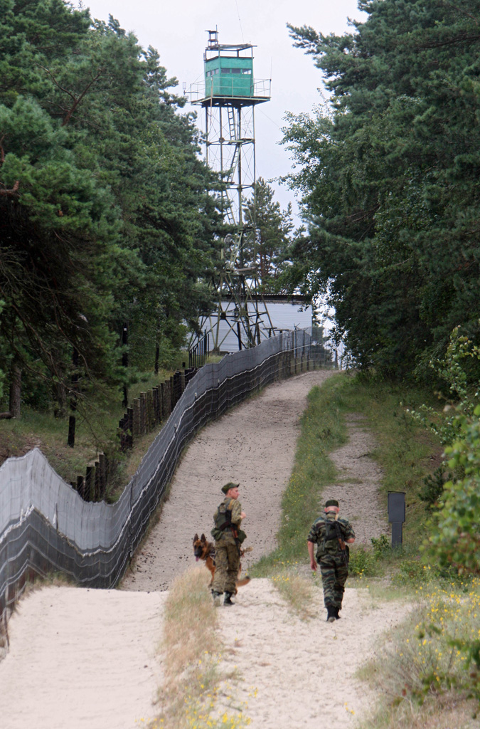
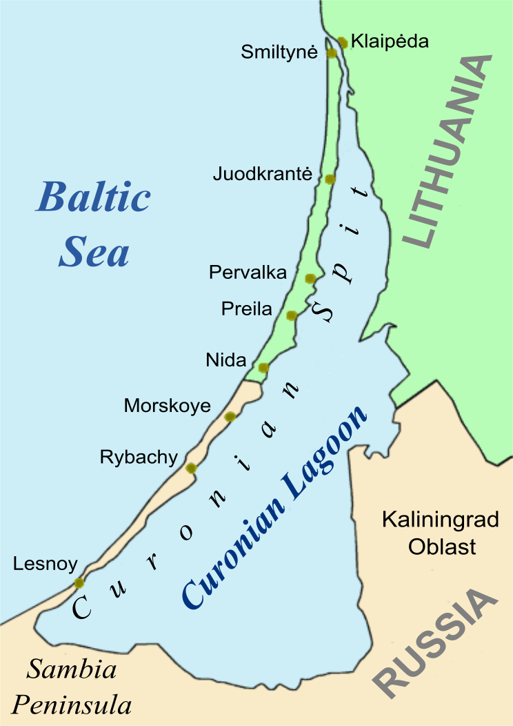
The Curonian (Courish) Spit ( lt, Kuršių nerija; russian: Ку́ршская коса́ (Kurshskaya kosa); german: Kurische Nehrung, ; lv, Kuršu kāpas) is a long, thin, curved sand-dune spit that separates the Curonian Lagoon from the Baltic Sea coast. Its southern portion lies within Kaliningrad Oblast, Russia, and its northern within southwestern Klaipėda County, Lithuania. It is a UNESCO World Heritage Site shared by Lithuania and Russia. Geography The Curonian Spit stretches from the Sambia Peninsula on the south to its northern tip next to a narrow strait, across which is the port city of Klaipėda on the mainland of Lithuania. The northern long stretch of the Curonian Spit peninsula belongs to Klaipėda County, Lithuania, while the rest is part of the Kaliningrad Oblast, Russia. The width of the spit varies from a minimum of in Russia (near the village of Lesnoy) to a maximum of in Lithuania (just north of Nida). Geologic history The Curonian Spit was formed ... [...More Info...] [...Related Items...] OR: [Wikipedia] [Google] [Baidu] |


