|
Linga Sound (Shetland)
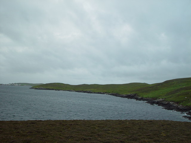
Linga Sound is the strait between the islands of Whalsay and West Linga in the Shetland islands of Scotland. The sound has a depth of . The narrowest width is between the contours. The sound is the channel most often used by large vessels. The tidal stream running south through the sound starts about four and a half hours before high water at Lerwick, and the stream starts running north about two hours after high water at Lerwick. The maximum rate is 6 knots. The sound has several islets. The most notable is the Skate of Marrister The Skate of Marrister is a flat ledge that extends about from the western shore of Whalsay, in the Shetland islands of Scotland. It is slightly more than north-north-west from Symbister Ness off the village of Marrister, in Linga Sound (Shetla .... A lighthouse on Suther Ness below Brough stands at the northern entrance into Linga Sound. File:Westlinga.jpg, Looking SSW across the Bight of Cudda on the west of the sound towards the Head of Ber ... [...More Info...] [...Related Items...] OR: [Wikipedia] [Google] [Baidu] |
Whalsay
Whalsay ( sco, Whalsa; non, Hvalsey or ''Hvals-øy'', meaning 'Whale Island') is the sixth largest of the Shetland Islands in the north of Scotland. Geography Whalsay, also known as "The Bonnie Isle", is a peat-covered island in the Shetland Islands. It is situated east of the Shetland Mainland and has an area of . The main settlement is Symbister,Haswell-Smith (2004) pp. 454–55 where the fishing fleet is based. The fleet is composed of both pelagic and demersal vessels. Other main settlements include Clate, Isbister, Sandwick, Saltness, Huxter, Challister, Marrister, North Park and furthest north is Skaw. The island is fertile and fairly densely populated, with crofting taking second place to fishing as the main local industries. Transport Ferries sail from Symbister to Laxo and Vidlin on the Shetland Mainland. When normal service is in operation two ferries run a tandem service between Symbister and Laxo. Departure times from the two terminals are normally around ... [...More Info...] [...Related Items...] OR: [Wikipedia] [Google] [Baidu] |
West Linga
West Linga is an uninhabited island located between Mainland and Whalsay in Shetland, Scotland. Geography and geology West Linga is a long narrow island covered in rough heath. It is separated from Whalsay by Linga Sound, and Lunning on Mainland, Shetland to the west. Little Linga, Swarta Skerry, Lona Skerry and Ketill Holm lie to the west. The Calf of Linga to the south is a drying islet. Wether Holm is separated by a deep channel at the north end. There are two lochs, and a natural arch in the north west. The two main hills are at either end - North and South Ward. There is a cairn in the south. The rock is coarse micaceous, and hornblendic gneiss with granite veins. There is a raised beach above Croo Wick at the southern extremity. History West Linga appears to have been inhabited intermittently until the late 18th century. The lack of an anchorage and somewhat brackish water have hindered settlement. Some acreage on "Liungøuo í Hwalsøyo" is recorded in 14 ... [...More Info...] [...Related Items...] OR: [Wikipedia] [Google] [Baidu] |
Shetland
Shetland, also called the Shetland Islands and formerly Zetland, is a subarctic archipelago in Scotland lying between Orkney, the Faroe Islands and Norway. It is the northernmost region of the United Kingdom. The islands lie about to the northeast of Orkney, from mainland Scotland and west of Norway. They form part of the border between the Atlantic Ocean to the west and the North Sea to the east. Their total area is ,Shetland Islands Council (2012) p. 4 and the population totalled 22,920 in 2019. The islands comprise the Shetland (Scottish Parliament constituency), Shetland constituency of the Scottish Parliament. The local authority, the Shetland Islands Council, is one of the 32 council areas of Scotland. The islands' administrative centre and only burgh is Lerwick, which has been the capital of Shetland since 1708, before which time the capital was Scalloway. The archipelago has an oceanic climate, complex geology, rugged coastline, and many low, rolling hills. The lar ... [...More Info...] [...Related Items...] OR: [Wikipedia] [Google] [Baidu] |
Lerwick
Lerwick (; non, Leirvik; nrn, Larvik) is the main town and port of the Shetland archipelago, Scotland. Shetland's only burgh, Lerwick had a population of about 7,000 residents in 2010. Centred off the north coast of the Scottish mainland and on the east coast of the Shetland Mainland, Lerwick lies north-by-northeast of Aberdeen; west of the similarly sheltered port of Bergen in Norway; and south east of Tórshavn in the Faroe Islands. One of the UK's coastal weather stations is situated there, with the local climate having small seasonal variation due to the maritime influence. Being located further north than Saint Petersburg and the three mainland Nordic capitals, Lerwick's nights in the middle of summer only get dark twilight and winters have below six hours of complete daylight. History Lerwick is a name with roots in Old Norse and its local descendant, Norn, which was spoken in Shetland until the mid-19th century. The name "Lerwick" means ''bay of clay''. The c ... [...More Info...] [...Related Items...] OR: [Wikipedia] [Google] [Baidu] |
Skate Of Marrister
The Skate of Marrister is a flat ledge that extends about from the western shore of Whalsay, in the Shetland islands of Scotland. It is slightly more than north-north-west from Symbister Ness off the village of Marrister, in Linga Sound (Shetland), Linga Sound. At low tide the ledge rises above the water. There is a risk that the strong tide in Whalsay Sound (Linga Sound) will carry a boat onto the Skate. There is a minor light on the Skate with a nominal range of four miles, flashing green every six seconds. Pollock, Piltock may be caught around the skate. References Citations Sources * * * * Islets of Whalsay Uninhabited islands of Shetland Skerries of Scotland {{Shetland-geo-stub ... [...More Info...] [...Related Items...] OR: [Wikipedia] [Google] [Baidu] |
Brough, Shetland
Brough is a settlement in western Whalsay in the parish of Nesting in the Shetland islands of Scotland. It lies to the southwest of Challister, northeast of New Park, and north of Tripwell. To the north is Kirk Ness, and Whalsay Parish Church. History Historically, fishing has been the main source of income in Brough. There is a burnt mound in the south of the village and an old horizontal mill which first appeared on an 1882 map. Cup marks A feature here is a hillock with two groups of cup-marks at , believed to date to the Bronze Age The Bronze Age is a historic period, lasting approximately from 3300 BC to 1200 BC, characterized by the use of bronze, the presence of writing in some areas, and other early features of urban civilization. The Bronze Age is the second prin .... The upper group features 10 much-weathered cups, around 2 inches in diameter on average and as deep as an inch in an area of about 18 by 19 inches. The lower group features at least 19 we ... [...More Info...] [...Related Items...] OR: [Wikipedia] [Google] [Baidu] |
Straits Of Scotland
A strait is an oceanic landform connecting two seas or two other large areas of water. The surface water generally flows at the same elevation on both sides and through the strait in either direction. Most commonly, it is a narrow ocean channel that lies between two land masses. Some straits are not navigable, for example because they are either too narrow or too shallow, or because of an unnavigable reef or archipelago. Straits are also known to be loci for sediment accumulation. Usually, sand-size deposits occur on both the two opposite strait exits, forming subaqueous fans or deltas. Terminology The terms '' channel'', ''pass'', or ''passage'' can be synonymous and used interchangeably with ''strait'', although each is sometimes differentiated with varying senses. In Scotland, ''firth'' or ''Kyle'' are also sometimes used as synonyms for strait. Many straits are economically important. Straits can be important shipping routes and wars have been fought for control of the ... [...More Info...] [...Related Items...] OR: [Wikipedia] [Google] [Baidu] |


