|
Likasi
Likasi (formerly official names: Jadotville ( French) and Jadotstad (Dutch)) is a city in Haut-Katanga Province, in the south-east of the Democratic Republic of Congo. Demographics Likasi has a population of around 635,000 (2015). During the 1990s the United Nations set up feeding centres and refugee centres in and around Likasi to assist with the refugees fleeing ethnic violence in Shaba, whose arrival had increased the population of the town some 41,000. History Shinkolobwe mine, 20 km west of Likasi (then called Jadotville), was described by a 1943 Manhattan Project intelligence report as the most important deposit of uranium yet discovered in the world. The uranium from this mine was used to build the atomic bombs used in Hiroshima and Nagasaki in 1945. In 1961, during the United Nations intervention in the Katanga conflict, a company of Irish UN troops deployed to Jadotville was besieged and eventually surrendered to troops loyal to the Katangese Prime Minister Moï ... [...More Info...] [...Related Items...] OR: [Wikipedia] [Google] [Baidu] |
Kamatanda
Kamatanda is a region just north of Likasi in the Haut-Katanga Province of the Democratic Republic of the Congo. It gives its name to an open-pit copper mine, a railway junction, an abandoned airport and a residential area of Likasi. The Sanga people mined copper at Kamatanda in the pre-colonial period. The Belgian Union Minière du Haut-Katanga (UMHK) was established in 1906 and took over the mine. In 1966 possession passed to the state-owned Gécamines. Gécamines allowed artisanal miners to operate the mine, working in dangerous conditions for very low pay. The miners established an informal residential community around the mine, which suffered from lack of clean water and power, lack of drainage and pollution. Starting in 2016 Gécamines began modernizing the operation. A new ore crushing plant came into operation in 2019. Location In the early days Kamatanda was also called Sofumwango. It is in the Kambove District of Haut-Katanga Province. It is a few kilometers northeast o ... [...More Info...] [...Related Items...] OR: [Wikipedia] [Google] [Baidu] |
Shituru
Shituru is a town that is now a commune of the city of Likasi in Haut-Katanga province, Democratic Republic of the Congo. It is also the location of a copper mine, smelter and hydrometallurgical plant that was operated by the state-owned Gécamines. Shituru was the site of an open cast copper mine that had been abandoned as of 1992. The ''East China Capital Holdings Ltd.'' held an option to acquire a 75% stake in the Shituru mine from Gecamines. In May 2005, ''International Barytex Resources Ltd.'' announced that it was buying a 86.67% stake in ''East China Capital Holdings'' for an effective 65% interest in ''Shituru Mining Corporation sprl'' (SMCO), the joint venture which holds the mine itself. In September 2008 Gécamines' partner, International Barytex Resources of Vancouver, British Columbia Vancouver ( ) is a major city in western Canada, located in the Lower Mainland region of British Columbia. As the List of cities in British Columbia, most populous city in the pro ... [...More Info...] [...Related Items...] OR: [Wikipedia] [Google] [Baidu] |
Siege Of Jadotville
In the Siege of Jadotville in September 1961, a small contingent of the Irish Army's 35th Battalion, designated "A" Company, serving as part of the United Nations Operation in the Congo (''Opération des Nations Unies au Congo'', ONUC) were besieged in the mining town of Jadotville (modern-day Likasi) by Katangese forces loyal to the secessionist State of Katanga. The siege took place during the seven-day escalation of a stand-off between ONUC and Katangese forces during Operation Morthor. Although the contingent of 155 Irish soldiers repelled attacks by a 3,000-man Katangese force for five days while an undersized relief force of Irish, Indian and Swedish troops attempted to reach them, they were eventually forced to surrender having run out of ammunition and water. "A" Company was subsequently held as prisoners of war for approximately one month. The Irish forces inflicted approximately 1,300 casualties (including up to 300 killed) on the Congolese force, with no deaths am ... [...More Info...] [...Related Items...] OR: [Wikipedia] [Google] [Baidu] |
Railway Stations In DRCongo
Railway stations in the Democratic Republic of Congo (DR Congo) include: Maps UN Map WestUN Map East* Stations served by passenger trains Stations served by rail Existing Matadi–Kinshasa Railway * Ango-Ango * Matadi * Mpozo * Kenge * Songololo * Mbanza-Ngungu * Kimpese * Lukala- cement works * Kintoni * Kwilu Ngongo * Kisuntu * Inkisi aka Kisantu * Matete * Madimba * Kindamba ** Dembo * Kasangulu * (start of suburban area) * Mont Ngafula * Kinsenso * Matete * Ndjili * Limete - Kinshasa - national capital; (river port railhead) * (proposed road-rail bridge on border.) * Brazzaville ---- * Barumbu * La Gombe * Kitambo * Ngaliema * (local line to west) ---- * (local line to east) * Limbe * Masina * Kinshasa Airport ---- Inland lines ---- * Ilebo - (river port railhead) * Bakwa-Kasanga * Mweka * Demba * Kananga (was Luluabourg) * Kamwandu * Kazumba * Mwene Ditu * Lusuku * Kamina - junction to north * Tenke - junction to Angola * ... [...More Info...] [...Related Items...] OR: [Wikipedia] [Google] [Baidu] |
Likasi (commune)
Likasi is a commune of the city of Likasi in the Democratic Republic of the Congo The Democratic Republic of the Congo (french: République démocratique du Congo (RDC), colloquially "La RDC" ), informally Congo-Kinshasa, DR Congo, the DRC, the DROC, or the Congo, and formerly and also colloquially Zaire, is a country in .... Populated places in Haut-Katanga Province {{DRC-geo-stub ... [...More Info...] [...Related Items...] OR: [Wikipedia] [Google] [Baidu] |
Haut-Katanga Province
Haut-Katanga (French for "Upper Katanga") is one of the 21 new provinces of the Democratic Republic of the Congo created in the 2015 repartitioning. Haut-Katanga, Haut-Lomami, Lualaba, and Tanganyika provinces are the result of the dismemberment of the former Katanga province. Haut-Katanga was formed from the Haut-Katanga district and the independently administered cities of Likasi and Lubumbashi. Lubumbashi retained its status as a provincial capital. The new province's territory corresponds to the historic Katanga-Oriental that existed in the early period after independence between 1963 and 1966. Territories Its current territories are: * Kasenga * Kipushi * Mitwaba * Pweto * Sakania Sakania is a town in Haut-Katanga Province, in the Congo Pedicle, in the far south of the Democratic Republic of Congo, near the border with Zambia. It is located at an elevation of 1278m asl, therefore it has a cool climate. Between 1935 and 1939 i ... Approximate correspondence between ... [...More Info...] [...Related Items...] OR: [Wikipedia] [Google] [Baidu] |
Kikula
Kikula is a commune of the city of Likasi in the Democratic Republic of the Congo The Democratic Republic of the Congo (french: République démocratique du Congo (RDC), colloquially "La RDC" ), informally Congo-Kinshasa, DR Congo, the DRC, the DROC, or the Congo, and formerly and also colloquially Zaire, is a country in .... Populated places in Haut-Katanga Province {{DRC-geo-stub ... [...More Info...] [...Related Items...] OR: [Wikipedia] [Google] [Baidu] |
Panda, Likasi
Panda is a commune of the city of Likasi in the Democratic Republic of the Congo The Democratic Republic of the Congo (french: République démocratique du Congo (RDC), colloquially "La RDC" ), informally Congo-Kinshasa, DR Congo, the DRC, the DROC, or the Congo, and formerly and also colloquially Zaire, is a country in .... Populated places in Haut-Katanga Province Democratic Republic of Congo geography articles needing translation from French Wikipedia {{DRC-geo-stub ... [...More Info...] [...Related Items...] OR: [Wikipedia] [Google] [Baidu] |
Shaba Province
Katanga was one of the four large provinces created in the Belgian Congo in 1914. It was one of the eleven provinces of the Democratic Republic of the Congo between 1966 and 2015, when it was split into the Tanganyika, Haut-Lomami, Lualaba, and Haut-Katanga provinces. Between 1971 and 1997 (during the rule of Mobutu Sese Seko when Congo was known as Zaire), its official name was Shaba Province. Katanga's area encompassed . Farming and ranching are carried out on the Katanga Plateau. The eastern part of the province is considered to be a rich mining region, which supplies cobalt, copper, tin, radium, uranium, and diamonds. The region's former capital, Lubumbashi, is the second-largest city in the Congo. History Copper mining in Katanga dates back over 1,000 years, and mines in the region were producing standard-sized ingots of copper for international transport by the end of the 10th century CE. In the 1890s, the province was beleaguered from the south by Cecil Rhodes' No ... [...More Info...] [...Related Items...] OR: [Wikipedia] [Google] [Baidu] |
Shinkolobwe
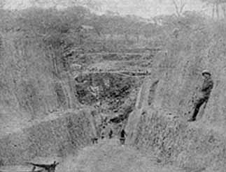
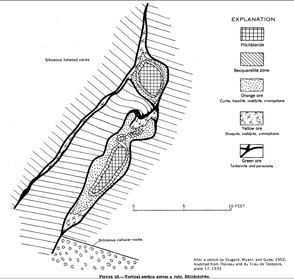
Shinkolobwe, or Kasolo, or Chinkolobew, or Shainkolobwe, was a radium and uranium mine in the Haut-Katanga Province of the Democratic Republic of the Congo (DRC), located 20 km west of Likasi (formerly Jadotville), 20 km south of Kambove, and about 145 km northwest of Lubumbashi. The mine produced the most economical uranium ore in the world and was used for the Manhattan Project and subsequent nuclear weapons produced by the United States in the 1940s and 50s. Before World War II, uranium extracted here was originally taken to Belgium to be processed; this supply was captured by the Wehrmacht in 1940 and subsequently used for the unsuccessful German nuclear program. The Shinkolobwe mine was officially closed in 2004. Toponym The mine's name was taken from the long-gone nearby village of Shinkolobwe, which is the indigenous thorny fruit in the Lingala language. It is also slang for "a man who is easygoing on the surface but who becomes angry when provoked". ... [...More Info...] [...Related Items...] OR: [Wikipedia] [Google] [Baidu] |
Humid Subtropical Climate
A humid subtropical climate is a zone of climate characterized by hot and humid summers, and cool to mild winters. These climates normally lie on the southeast side of all continents (except Antarctica), generally between latitudes 25° and 40° and are located poleward from adjacent tropical climates. It is also known as warm temperate climate in some climate classifications. Under the Köppen climate classification, ''Cfa'' and ''Cwa'' climates are either described as humid subtropical climates or warm temperate climates. This climate features mean temperature in the coldest month between (or ) and and mean temperature in the warmest month or higher. However, while some climatologists have opted to describe this climate type as a "humid subtropical climate", Köppen himself never used this term. The humid subtropical climate classification was officially created under the Trewartha climate classification. In this classification, climates are termed humid subtropical when the ... [...More Info...] [...Related Items...] OR: [Wikipedia] [Google] [Baidu] |


.jpg)


