|
Leuggelbach
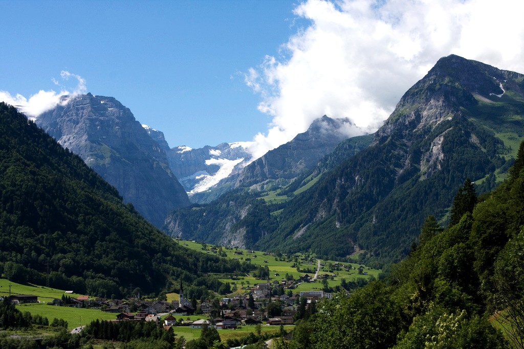
Leuggelbach is a village, and former municipality, in the municipality of Glarus Süd and canton of Glarus in Switzerland. History Leuggelbach is first mentioned in 1350 as ''Löckelbach''. Several factories opened in the 19th century, including a calico factory that closed in 1930 and a textile finishing factory that closed in 1993. Today all that remains is a paint and varnish factory, along with some craft enterprises. On 1 July 2006 the municipality of Leuggelbach was merged into the municipality of Haslen. On 1 January 2011, the municipality of Haslen was itself merged into the new municipality of Glarus Süd. Geography Leuggelbach is located in the valley of the Linth river, with the village situated on the west bank of the river at an elevation of approximately . Luchsingen lies to the south, Nidfurn is to the north, and Haslen is across the river to the north and east. Transport Leuggelbach is located on the Hauptstrasse 17, which runs the length of the canton of ... [...More Info...] [...Related Items...] OR: [Wikipedia] [Google] [Baidu] |
Leuggelbach Railway Station
Leuggelbach railway station is a railway station in the municipality of Glarus Süd in the Swiss canton of Glarus. It takes its name from the nearby village of Leuggelbach Leuggelbach is a village, and former municipality, in the municipality of Glarus Süd and canton of Glarus in Switzerland. History Leuggelbach is first mentioned in 1350 as ''Löckelbach''. Several factories opened in the 19th century, includ .... The station is situated on the Weesen to Linthal railway line, and served by the hourly Zürich S-Bahn service S25 between Zurich and Linthal. References Railway stations in the canton of Glarus Swiss Federal Railways stations {{Switzerland-railstation-stub ... [...More Info...] [...Related Items...] OR: [Wikipedia] [Google] [Baidu] |
Glarus Süd
Glarus Süd is a municipality in the Swiss canton of Glarus. It comprises the upper Linth valley, and the entire Sernf valley, and includes the villages of Betschwanden, Braunwald, Diesbach, Elm, Engi, Haslen, Hätzingen, Leuggelbach, Linthal, Luchsingen, Matt, Mitlödi, Nidfurn, Rüti, Schwanden, Schwändi and Sool. Glarus Süd is one of three municipalities of the canton of Glarus, the others being Glarus and Glarus Nord. History The municipality of Glarus Süd was created on 1 January 2011, incorporating the former municipalities of Betschwanden, Braunwald, Elm, Engi, Haslen, Linthal, Luchsingen, Matt, Mitlödi, Rüti, Schwanden, Schwändi and Sool. At the time of its creation, Glarus Süd was the largest Swiss municipality by area. As of 1 January 2015, it was overtaken in size by the expanded municipality of Scuol in the canton of Graubünden. Geography Glarus Süd incorporates all of the valley of the Linth river from Mitlödi, just upstream of the tow ... [...More Info...] [...Related Items...] OR: [Wikipedia] [Google] [Baidu] |
Haslen, Glarus
Haslen is a village, and former municipality, in the municipality of Glarus Süd and canton of Glarus in Switzerland. History Haslen is first mentioned in 1289 as ''Burchard von Hasle''. On 1 July 2006, the municipality of Haslen incorporated the neighbouring municipalities of Leuggelbach and Nidfurn. On 1 January 2011, Haslen was itself merged into the new municipality of Glarus Süd. Geography Haslen is in the valley of the Linth river, and the village is on the east bank of the river at an elevation of approximately . The villages of Leuggelbach and Diesbach lie across the river to the west, whilst Hätzingen is to the south and Schwanden is to the north. Haslen consists of the linear village of Haslen itself, the hamlets of Leu (formerly Nesslau), Oberhaslen, Büel, Zussigen and Mülibächli. Haslen has an area, as defined by the former municipal boundaries in 2006, of . Of this area, 42.9% is used for agricultural purposes, while 45.2% is forested. Of the rest of th ... [...More Info...] [...Related Items...] OR: [Wikipedia] [Google] [Baidu] |
Linth River
The Linth (pronounced "lint") is a Swiss river that rises near the village of Linthal in the mountains of the canton of Glarus, and eventually flows into the Obersee section of Lake Zurich. It is about in length. The water power of the Linth was a main factor in the creation of the textile industry of the canton Glarus, and is today used to drive the Linth–Limmern power stations in its upper reaches. The river and its upper valley forms the boundary between the mountain ranges of the Glarus Alps, to its east and south, and the Schwyzer Alps, to its west. Course of the river The river rises to the south-west of the village of Linthal, at the foot the Tödi mountain (elevation ). It collects the water from several glaciers, including the Clariden Glacier and the Biferten Glacier, as well as various tributary streams, including the ''Oberstafelbach'', the ''Bifertenbach'', the ''Sandbach'', the ''Walenbach'' and the ''Limmerenbach''. The last of these is dammed to create t ... [...More Info...] [...Related Items...] OR: [Wikipedia] [Google] [Baidu] |
Canton Of Glarus
The canton of Glarus (german: Kanton Glarus rm, Chantun Glaruna; french: Canton de Glaris; it, Canton Glarona) is a canton in east central Switzerland. The capital is Glarus. The population speaks a variety of Alemannic German. The majority of the population (81%) identifies as Christian, about evenly split between Protestants and Catholics. History According to legend, the inhabitants of the Linth Valley were converted to Christianity in the 6th century by the Irish monk Saint Fridolin, the founder of Säckingen Abbey in what is now the German state of Baden-Württemberg. From the 9th century, the area around Glarus was owned by Säckingen Abbey, the town of Glarus being recorded as ''Clarona''. The Alemanni began to settle in the valley from the early 8th century. The Alemannic German language took hold only gradually, and was dominant by the 11th century. By 1288, the Habsburgs had claimed all the abbey's rights. Glarus joined the Old Swiss Confederacy in 1352 as one of t ... [...More Info...] [...Related Items...] OR: [Wikipedia] [Google] [Baidu] |
S25 (ZVV)
The S25 is a regional railway line of the S-Bahn Zürich on the Zürcher Verkehrsverbund (ZVV), Zürich transportation network, and is one of the network's lines connecting the cantons of Zürich with Schwyz, Glarus and St. Gallen. The line was introduced in July 2014, and replaces the less frequent Glarner Sprinter train. History Between 1918 and 2004, there was no direct connection from the canton of Glarus to the city of Zürich. In 2004, the through Glarner Sprinter train was introduced, but financial and technical limitations meant this train only ran every two hours on weekdays, and twice a day on weekends and holidays. It also only reached Linthal, the terminus of the line in Glarus, on weekends and holidays. In July 2014, these limitations were finally overcome, and the Glarner Sprinter was replaced by the hourly S25 service to Linthal. Route * The line links Zürich Hauptbahnhof with the canton of Glarus, terminating at the village of Linthal and the head of ... [...More Info...] [...Related Items...] OR: [Wikipedia] [Google] [Baidu] |
Canton Of Glarus
The canton of Glarus (german: Kanton Glarus rm, Chantun Glaruna; french: Canton de Glaris; it, Canton Glarona) is a canton in east central Switzerland. The capital is Glarus. The population speaks a variety of Alemannic German. The majority of the population (81%) identifies as Christian, about evenly split between Protestants and Catholics. History According to legend, the inhabitants of the Linth Valley were converted to Christianity in the 6th century by the Irish monk Saint Fridolin, the founder of Säckingen Abbey in what is now the German state of Baden-Württemberg. From the 9th century, the area around Glarus was owned by Säckingen Abbey, the town of Glarus being recorded as ''Clarona''. The Alemanni began to settle in the valley from the early 8th century. The Alemannic German language took hold only gradually, and was dominant by the 11th century. By 1288, the Habsburgs had claimed all the abbey's rights. Glarus joined the Old Swiss Confederacy in 1352 as one of t ... [...More Info...] [...Related Items...] OR: [Wikipedia] [Google] [Baidu] |
Luchsingen
Luchsingen is a village, and former municipality, in the municipality of Glarus Süd and canton of Glarus in Switzerland. History Luchsingen is first mentioned in 1274 as ''Luchsingen''. In 2004 the former municipalities of Hätzingen and Diesbach were merged into the municipality of Luchsingen. On 1 January 2011, the enlarged municipality became part of the municipality of Glarus Süd. Geography Luchsingen is located in the valley of the Linth river, with the village located on the west bank of the river at an elevation of approximately . Leuggelbach lies to the north, whilst Hätzingen lies across the river to the south. Besides the village of Luchsingen, the area includes the hamlet of Adlenbach and the vacation home development of Schlatt. Above the village to the west is the valley of the Bächibach stream and the Oberblegisee lake (at an elevation of ), which are below the mountains of Eggstock (), Bös Fulen (), Rüchigrat () and Glärnisch (). Luchsingen has an are ... [...More Info...] [...Related Items...] OR: [Wikipedia] [Google] [Baidu] |
Nidfurn
Nidfurn is a village, and former municipality, in the municipality of Glarus Süd and canton of Glarus in Switzerland. History Nidfurn is first mentioned in 1289 as ''Nitfúre''. Nidfurn belonged to Säckingen Abbey until 1395. During the middle ages, it was one of the richest parts of Glarus. Until the 20th century, the principal economic activity in the village was the raising of cattle, sheep and goats, with the dairy industry developing in the 18th century. Cotton spinning by hand was also common in the 18th century, but this never developed into factory-based industrial activity. In 1879, Linthal was connected to the Swiss railway network by the opening of the Swiss Northeastern Railway line from Weesen to Linthal. On 1 July 2006, the municipality of Nidfurn was merged into the municipality of Haslen. On 1 January 2011, the municipality of Haslen was itself merged into the new municipality of Glarus Süd. Geography Nidfurn is located in the valley of the Linth river, w ... [...More Info...] [...Related Items...] OR: [Wikipedia] [Google] [Baidu] |
Canton Of Uri
The canton of Uri (german: Kanton Uri rm, Chantun Uri; french: Canton d'Uri; it, Canton Uri) is one of the 26 cantons of Switzerland and a founding member of the Swiss Confederation. It is located in Central Switzerland. The canton's territory covers the valley of the Reuss between the St. Gotthard Pass and Lake Lucerne. The official language of Uri is (the Swiss variety of Standard) German, but the main spoken dialect is the Alemannic Swiss German called . Uri was once the only canton whose children in school had to learn Italian as their first foreign language, but in the school year of 2005/2006, that was changed to English, as in other Central and Northeastern Swiss cantons. The canton's population is about 35,000, of which 3,046 (or 8.7%) are foreigners. The legendary William Tell is said to have hailed from Uri. The historical landmark Rütli lies within the canton of Uri. Name The name of the valley is first mentioned in the 8th or 9th century, in the Latinized f ... [...More Info...] [...Related Items...] OR: [Wikipedia] [Google] [Baidu] |
Linthal, Glarus
Linthal is a village, and former municipality, in the municipality of Glarus Süd and canton of Glarus in Switzerland. The village lies near the head of the valley of the Linth river, and at the foot of the Klausen Pass into the canton of Uri. It is the terminus of the railway line that traverses the length of Glarus. History Linthal is first mentioned in 1289 as ''Lintal''. In 1879, Linthal was connected to the Swiss railway network by the opening of the Swiss Northeastern Railway line from Weesen. The road over the Klausen Pass was built between 1895 and 1900. Construction of the Linth–Limmern hydro-electric power scheme, in the mountains above Linthal, commenced in 1957, and was fully operational by 1968. In 2011, the municipality of Linthal was merged into the new municipality of Glarus Süd. Geography The village Linthal lies at the head of the valley of the Linth river, at an altitude of approximately . It is surrounded by mountains, including Ortstock (), Clariden ... [...More Info...] [...Related Items...] OR: [Wikipedia] [Google] [Baidu] |


