|
Glarus Süd
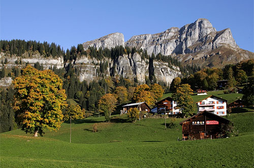
Glarus Süd is a municipality in the Swiss canton of Glarus. It comprises the upper Linth valley, and the entire Sernf valley, and includes the villages of Betschwanden, Braunwald, Diesbach, Elm, Engi, Haslen, Hätzingen, Leuggelbach, Linthal, Luchsingen, Matt, Mitlödi, Nidfurn, Rüti, Schwanden, Schwändi and Sool. Glarus Süd is one of three municipalities of the canton of Glarus, the others being Glarus and Glarus Nord. History The municipality of Glarus Süd was created on 1 January 2011, incorporating the former municipalities of Betschwanden, Braunwald, Elm, Engi, Haslen, Linthal, Luchsingen, Matt, Mitlödi, Rüti, Schwanden, Schwändi and Sool. At the time of its creation, Glarus Süd was the largest Swiss municipality by area. As of 1 January 2015, it was overtaken in size by the expanded municipality of Scuol in the canton of Graubünden. Geography Glarus Süd incorporates all of the valley of the Linth river from Mitlödi, just upstream of the tow ... [...More Info...] [...Related Items...] OR: [Wikipedia] [Google] [Baidu] |
Betschwanden
Betschwanden is a village, and former municipality, in the municipality of Glarus Süd and canton of Glarus in Switzerland. History Betschwanden is first recorded in 1240 in the phrase ''in Beswando''. Until 1395, Betschwanden was obliged to pay tithes and taxes to Säckingen Abbey. At the same time it was part of the parish of Glarus. The village church was built in the Romanesque style in the 14th century. It was rebuilt several times and flood control walls were added in 1779-80. The Art Nouveau and Gothic Revival elements were added in 1915 and restored in 1975-77. The exterior of the church was rebuilt in 2001. When the Protestant Reformation arrived in Glarus, Betschwanden adopted the new faith. In 1528 it joined a Reformed parish with Braunwald, Hätzingen, Diesbach and Rüti. In 1942 Braunwald separated to form an independent parish. Until the 19th century, alpine farming and herding was the primary source of income. A mill was built on the Diesbach river in 1778. ... [...More Info...] [...Related Items...] OR: [Wikipedia] [Google] [Baidu] |
Glarus
, neighboring_municipalities= Glarus Nord, Glarus Süd, Muotathal (SZ), Innerthal (SZ) , twintowns= Wiesbaden-Biebrich (Germany) } Glarus (; gsw, Glaris; french: Glaris; it, Glarona; rm, Glaruna) is the capital of the canton of Glarus in Switzerland. Since 1 January 2011, the municipality Glarus incorporates the former municipalities of Ennenda, Netstal and Riedern.Amtliches Gemeindeverzeichnis der Schweiz published by the Swiss Federal Statistical Office accessed 18 February 2011 Glarus lies on the river Linth between the foot of the Glärnisch (part of the Schwyzer Alps) to the west and the Schilt (Glarus Alps) to the east. Very few buildings built before the fire of 1861 remain. Wood, textile, and plastics, as well as printing, are the dominant indu ... [...More Info...] [...Related Items...] OR: [Wikipedia] [Google] [Baidu] |
Sumvitg
Sumvitg (; german: Somvix) is a municipality in the Surselva Region in the canton of Graubünden in Switzerland. History Sumvitg is first mentioned in 1175 as ''in Summovico''. Geography Sumvitg has an area, , of . Of this area, 24.8% is used for agricultural purposes, while 26.8% is forested. Of the rest of the land, 1.3% is settled (buildings or roads) and the remainder (47.1%) is non-productive (rivers, glaciers or mountains). Before 2017, the municipality was located in the Disentis sub-district of the Surselva district, after 2017 it was part of the Surselva Region. It covers both sides of the Vorderrhein valley and the ''Val Sumvitg''. It consists of the village of Sumvitg and the hamlets of Surrein, Rabius, Laus and Compadials as well as numerous farm houses. Until 1986 Sumvitg was known by its German name as ''Somvix''. [...More Info...] [...Related Items...] OR: [Wikipedia] [Google] [Baidu] |
Trun, Switzerland
Trun is a municipality in the Surselva Region in the canton of Graubünden in Switzerland. The municipality of Schlans merged on 1 January 2012 into the municipality of Trun.Amtliches Gemeindeverzeichnis der Schweiz published by the Swiss Federal Statistical Office accessed 21 December 2011 History Trun is first mentioned in 765 as ''Tauronto''.Geography Trun has an area, , of . Of this area, 23.6% is used for agricultural purposes, while 34% is forested. Of the rest of the land, 1.9% is settled (buildings or roads) and the remainder (40.5%) is non-productive (rivers, glaciers or mountains). Following the 2012 merger, the new area was . Before 2017, the municipality was located in ...[...More Info...] [...Related Items...] OR: [Wikipedia] [Google] [Baidu] |
Breil/Brigels
Breil/Brigels is a municipality in the Surselva Region in the Swiss canton of Graubünden. On 1 January 2018 the former municipalities of Andiast and Waltensburg/Vuorz merged into the municipality of Breil/Brigels. The name of the municipality comes from the word ''brigilo'', meaning ''little town''. The name comes from the village name in the two local languages. In Romansh the name is while in German it is . History While the area was settled in the late Roman era or Early Middle Ages, Breil/Brigels is first mentioned in 765 as ''in Bregelo'' when the Bishop of Chur granted a farm in Breil/Brigels to Disentis Abbey. Shortly thereafter, the Abbey established a church and fortification on St. Eusebius' hill near the village. The village church of S. Maria and the chapel of S. Sievi (''Chaplutta Son Sievi'') both came under control of the Abbey in 1185 at the order of the Pope. New immigrants, known as the ''Freie von Laax'', moved into the village during the middle ages ... [...More Info...] [...Related Items...] OR: [Wikipedia] [Google] [Baidu] |
Waltensburg/Vuorz
Waltensburg/Vuorz is a former municipality in the Surselva Region in the canton of Graubünden in Switzerland. On 1 January 2018 the former municipalities of Andiast and Waltensburg/Vuorz merged into the municipality of Breil/Brigels. History Waltensburg/Vuorz was first mentioned in 765 as ''Vorce''. The German name of Waltensburg is first mentioned in 1209 as ''Waltramsburg'', which was an older name of the castle ''Jörgenberg''. While the Romansh speaking population used the older, Romansh name of Vorce (meaning: "a river fork") the former name of the castle moved to include the village. At about the same time, the castle came to be known as Jörgenberg from the name of the nearby early medieval fortified Church of St George. In the Middle Ages, the nearby settlements on Ladral () and Jörgenberg belonged to Waltensburg. In the area surrounding Waltensburg/Vuorz there are three other medieval fortresses, Grünenfels ( rm, Chischlatsch), home of the Freiherren of Grünen ... [...More Info...] [...Related Items...] OR: [Wikipedia] [Google] [Baidu] |
Andiast
Andiast () is a former municipality in the Surselva Region in the Swiss canton of Graubünden. Until 1943, it was known as Andest.Amtliches Gemeindeverzeichnis der Schweiz published by the Swiss Federal Statistical Office accessed 23 September 2009 Lying close to the ski resorts of and , Andiast is known for its winter sports. On 1 January 2018 the former municipalities of Andiast and |
Ilanz/Glion
Ilanz/Glion (german: Ilanz ; rm, Glion ) is a municipality in the Surselva Region in the Swiss canton of Graubünden. On 1 January 2014 the former municipalities of Castrisch, Ilanz, Ladir, Luven, Pitasch, Riein, Ruschein, Schnaus, Sevgein, Duvin, Pigniu, Rueun, and Siat merged into the new municipality of Ilanz/Glion.Nomenklaturen – Amtliches Gemeindeverzeichnis der Schweiz accessed 13 December 2014 History Castrisch is first mentioned in 765 as ''Castrices''. Ladir is first mentioned about 850 as ''Leitura''. Luven is first mentioned in 765 as ''Lobene''. Pitasch is first mentioned about 801–50 as ''Pictaui'' though this co ...[...More Info...] [...Related Items...] OR: [Wikipedia] [Google] [Baidu] |
Laax
Laax ( rm, Lags) is a municipality in the Surselva Region in the Swiss canton of Graubünden. History Laax is first mentioned c. 1290–98 as ''Lags''. Geography Laax has an area, , of . Of this area, 35.8% is used for agricultural purposes, while 30.6% is forested. Of the rest of the land, 3.6% is settled (buildings or roads) and the remainder (29.9%) is non-productive (rivers, glaciers or mountains). Before 2017, the municipality was located in the Ilanz sub-district of the Surselva district, after 2017 it was part of the Surselva Region. accessed 16 February 2017 The municipality of Laax stretches from the village it ... [...More Info...] [...Related Items...] OR: [Wikipedia] [Google] [Baidu] |
Flims
Flims ( rm, Flem) is a municipality in the Imboden Region in the Swiss canton of Graubünden. The town of Flims is dominated by the Flimserstein which one can see from almost anywhere in the area. Flims consists of the village of Flims (called Flims Dorf) and the hamlets of Fidaz and Scheia as well as Flims-Waldhaus, the initial birthplace of tourism in Flims, where most of the hotels were built before and after around 1900. Geography Flims has an area of . Of this area, 33.7% is used for agricultural purposes, while 28.9% is forested. Of the rest of the land, 3.6% is settled (buildings or roads) and the remainder (33.9%) is non-productive (rivers, glaciers or mountains). Before 2017, the municipality was located in the Trin sub-district, of the Imboden district, after 2017 it was part of the Imboden Region. Flims is located on a terrace north of the Rhine valley, forming the Ruinaulta gorge here. The country-side has numerous streams and lakes north of the village, from ... [...More Info...] [...Related Items...] OR: [Wikipedia] [Google] [Baidu] |
Pfäfers
Pfäfers is a municipality in the ''Wahlkreis'' (constituency) of Sarganserland in the canton of St. Gallen in Switzerland. The villages Pfäfers, St. Margrethenberg, Vadura, Valens, Vasön and Vättis belong to the municipality. History The ''Taminatal'' can look back on a long history of settlement. In the ''Drachenloch'' above Vättis stonetools of cavemen and bones of bears, perhaps 50,000 years old, were found. Examples from the find are on display in the local museum in Vättis. Pfäfers reached importance through the foundation of the Benedictine monastery, Pfäfers Abbey, in the first half of the 8th century. It existed for over a thousand years and was closed in 1838. Since 1847 the abbey premises have been used as a mental institution. Pfäfers is first mentioned in 762 as ''abbas de Fabarias''. In 1247 it was mentioned as ''Pheuers'' and in 1288 as ''Pfaevaers''. In Romansh it is known as ''Faveras''. In the 14th century Walser settled in the ''Calfeisental''. Un ... [...More Info...] [...Related Items...] OR: [Wikipedia] [Google] [Baidu] |
Mels
Mels is a municipality in the ''Wahlkreis'' (constituency) of Sarganserland in the Seeztal, canton of St. Gallen, Switzerland. History Mels is first mentioned in 765 as ''Maile'' though this comes from a later copy of the original document. In 1018 it was mentioned as ''Meilis''. Geography Mels has an area, , of . Of this area, 42.6% is used for agricultural purposes, while 29.3% is forested. Of the rest of the land, 2.6% is settled (buildings or roads) and the remainder (25.5%) is non-productive (rivers or lakes). The municipality is located in the Sarganserland ''Wahlkreis''. In terms of area, it is the largest municipality in the canton and covers the Weisstannen valley and a part of the Seez valley. Northwest of town is ''Castels'' hill and west of the Nidberg is Castels fortress. It consists of the village of Mels, the settlements of Heiligkreuz bei Mels, Plons, Ragnatsch, the hamlets of Butz, St. Martin, Mädris and Tils, the alpine settlement of Vermol as well as ... [...More Info...] [...Related Items...] OR: [Wikipedia] [Google] [Baidu] |


