|
La Torba
La Torba is a village in Tuscany, central Italy, administratively a frazione of the comune of Capalbio, province of Grosseto. At the time of the 2001 census its population amounted to 209. . Geography La Torba is about 50 km from and 12 km from Capalbio ...[...More Info...] [...Related Items...] OR: [Wikipedia] [Google] [Baidu] |
Province Of Grosseto
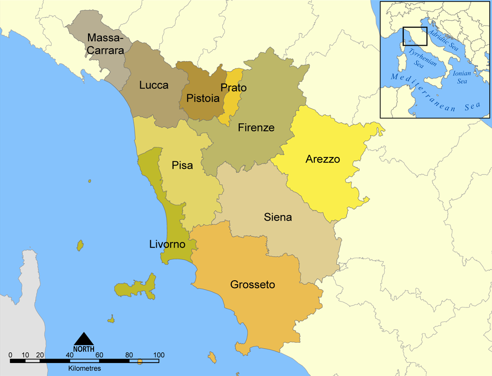
The province of Grosseto ( it, links=no, provincia di Grosseto) is a province in the Tuscany region of Italy. Its capital is the city of Grosseto. As of 2013 the province had a total population of 225,098 people. Geography The Province of Grosseto completely occupies the southern end of Tuscany, and with a territorial area of , it is the most extensive in the region and one of the least dense in population in Italy. The province is bordered to the northwest by the Province of Livorno, to the north by the Province of Pisa, to the northeast by the Province of Siena, and to the southeast by the Province of Viterbo in Lazio. To the south is the Tyrrhenian Sea, which includes the southern islands of the Tuscan archipelago, including Isola del Giglio and the smaller Giannutri islands and Formiche di Grosseto and Formica di Burano. The Arcipelago Toscano National Park spans both the provinces of Grosseto and Livorno, and includes the seven main islands of the Tuscan Archipelago: Elba ... [...More Info...] [...Related Items...] OR: [Wikipedia] [Google] [Baidu] |
Giardino, Capalbio
Giardino is a rural area in Tuscany, central Italy, administratively a frazione of the comune of Capalbio, province of Grosseto. At the time of the 2001 census its population amounted to 15. Geography Giardino is about 50 km from Grosseto and 12 km from Capalbio. It is situated in the plain of southern Maremma between the hills of Capalbio, Manciano and Orbetello, and the Tyrrhenian Sea. The valley of Giardino is commonly known as ''Valle d'Oro'' (Golden Valley) and it is surrounded by various heights of mountains, of which the highest peaks are those of Monte Nebbiello (127 meters), Poggio Imperiale (147 m), Poggio dei Butteri (154 m), Poggio Farletta (180 m) and Poggio Capalbiaccio (238 m). History Recent archaeological excavations proved that the valley was inhabited by the Etruscans dependent on the city of Vulci, as well as the Romans, as the hinterland of the colony of Cosa. Capalbio, prende forma il Parco archeologico e paesaggistico Valle d'Oro', Maremma Ma ... [...More Info...] [...Related Items...] OR: [Wikipedia] [Google] [Baidu] |
Chiarone Scalo
Chiarone Scalo is a village in Tuscany, central Italy, administratively a frazione of the comune of Capalbio, province of Grosseto. At the time of the 2001 census its population amounted to 18. Geography Chiarone Scalo is about 58 km from Grosseto and 11 km from Capalbio, and it is situated in the plain of southern Maremma between the hills of Capalbio and the Tyrrhenian Sea, next to the mouth of the river Chiarone, which marks the border between the provinces of Grosseto and Viterbo, Lazio. Chiarone Scalo is the southernmost village in Tuscany. History The small town was born in the late 18th century as border point and customs between the Grand Duchy of Tuscany and the Papal States and it developed in the next century with the opening of the railway station (1867). With the Maremman ''Riforma agraria'' (land reform) in the 1950s it became the centre for various newborn rural villages which converge on it: the hamlet of ''Selva Nera'' and several others named afte ... [...More Info...] [...Related Items...] OR: [Wikipedia] [Google] [Baidu] |
Capalbio Scalo
Capalbio Scalo is a village in Tuscany, central Italy, administratively a frazione of the comune of Capalbio, province of Grosseto. It had a population of 551 as of 2011. Geography Capalbio Scalo is about 50 km from Grosseto and 9 km from Capalbio. It is in the plain of southern Maremma between the hills of Capalbio and the Tyrrhenian Sea. Capalbio Scalo lies on the shore of Lago di Burano, an important natural reserve. Main sights * Church of Santa Maria Goretti (20th century) is the main parish church of the village. It was built in 1986 and consecrated by bishop Eugenio Binini. * Tower of Buranaccio (16th century), built by the State of Presidi, is on the shore of the Burano Lake. * Tower of Macchiatonda (17th century), coastal defense tower built by the State of Presidi, was restructured during the 19th century. It was used as a location in the 1969 movie '' The Seed of Man'' by director Marco Ferreri. Transport Capalbio Scalo is located along the Via Aure ... [...More Info...] [...Related Items...] OR: [Wikipedia] [Google] [Baidu] |
Borgo Carige
Borgo Carige is a village in Tuscany, central Italy, administratively a frazione of the comune of Capalbio, province of Grosseto. At the time of the 2001 census its population amounted to 229. Borgo Carige is about 54 km from Grosseto and 5 km from Capalbio, and it is situated in the plain of southern Maremma between the hills of Capalbio and the Tyrrhenian Sea. It is located along the Via Aurelia highway which links Grosseto to Rome. The village is an important town born as a result of the Maremman ''Riforma agraria'' (land reform) in the 1950s. Main sights * Church of ''Cuore Immacolato'' (20th century), main parish church of the village, it was built in 1958 and designed by Riccardo Medici in a Neo-Romanesque style.M. Del Francia, B. Catalani, ''Architettura contemporanea del paesaggio toscano'', Edizioni Edifir, Firenze, 2008, p. 31. References Bibliography * Fabiola Favilli, ''Capalbio. Alla scoperta del borgo e del territorio'', Arcidosso, C&P Adver Eff ... [...More Info...] [...Related Items...] OR: [Wikipedia] [Google] [Baidu] |
Roman Period
The Roman Empire ( la, Imperium Romanum ; grc-gre, Βασιλεία τῶν Ῥωμαίων, Basileía tôn Rhōmaíōn) was the post-Roman Republic, Republican period of ancient Rome. As a polity, it included large territorial holdings around the Mediterranean Sea in Europe, North Africa, and Western Asia, and was ruled by Roman emperor, emperors. From the Constitutional reforms of Augustus, accession of Caesar Augustus as the first Roman emperor to the Crisis of the Third Century, military anarchy of the 3rd century, it was a Principate with Roman Italy, Italia as the metropole of Roman province, its provinces and the Rome, city of Rome as its sole capital. The Empire was later ruled by dominate, multiple emperors who shared control over the Western Roman Empire and the Byzantine Empire#Early history, Eastern Roman Empire. The city of Rome remained the nominal capital of both parts until AD 476 when the imperial insignia were sent to Constantinople following the capture of ... [...More Info...] [...Related Items...] OR: [Wikipedia] [Google] [Baidu] |
Orbetello
Orbetello is a town and ''comune'' in the province of Grosseto (Tuscany), Italy. It is located about south of Grosseto, on the eponymous lagoon, which is home to an important Natural Reserve. History Orbetello was an ancient Etruscan settlement, which in 280 BC passed under the control of the Romans, who had founded their colony of Cosa (near the modern Ansedonia). The emperor Domitian had a substantial property here, which had belonged to the Domitii Ahenobarbi and he inherited through his wife Domitia Longina. He also built other sumptuous villas nearby for his courtiers. In the Middle Ages it was a possession of the Aldobrandeschi family, who held it until the 14th century, when it was acquired by the city of Orvieto. After several struggles with the Orsini of Pitigliano and Orvieto, in the following centuries Orbetello was captured by the Sienese Republic. In the mid-16th century it was part of the State of Presides, a Spanish possession, becoming its capital. The town ... [...More Info...] [...Related Items...] OR: [Wikipedia] [Google] [Baidu] |
Settefinestre
Villa Settefinestre lies between Capalbio and Orbetello in Tuscany, Italy, and is the site of a late Republican Roman slave-run villa owned by the senatorial family of the Volusii, built in the 1st century BC and enlarged in the 1st century AD with a large ''cryptoportico.'' The villa was fortified at a later period and the fortress was rebuilt as a villa in the more modern sense in the 15th century. It was excavated during 1976-1981 under the direction of Andrea Carandini and very thoroughly published. Villa Settefinestre itself was rehabilitated in the 1970s as a luxury holiday rental property, with the ruins, open to the public, picturesquely incorporated in the garden plan. The villa was located in the ''Ager Cosanus'' in the vicinity of Cosa, a Latin '' colonia'' founded in 273 BC. The area was linked to Rome by the Via Aurelia. Cosa suffered a crisis in the Roman Republican civil wars and became depopulated. In its stead, a group of great villas were assembled in the area, ... [...More Info...] [...Related Items...] OR: [Wikipedia] [Google] [Baidu] |
Via Aurelia
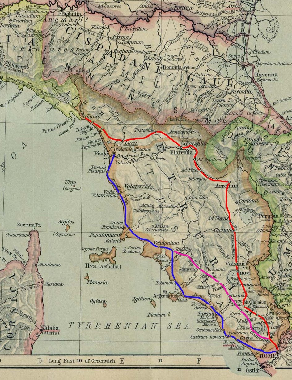
The ''Via Aurelia'' (Latin for "Aurelian Way") is a Roman road in Italy constructed in approximately 241 BC. The project was undertaken by Gaius Aurelius Cotta, who at that time was censor.Hornblower, Simon, & Antony Spawforth. ''The Oxford Classical Dictionary.'' 3rd ed. Oxford: Oxford University Press, 1996. Cotta had a history of building roads for Rome, as he had overseen the construction of a military road in Sicily (as consul in 252 BC, during the First Punic War) connecting ''Agrigentum'' (modern Agrigento) and ''Panormus'' (modern Palermo). Background In the middle Republic, a series of roads were built throughout Italy to serve the needs of Roman expansion, including swift army movements and reasonably quick communication with Roman colonies spread throughout Italy. There also was the unintended (but beneficial) consequence of an increase in trade among Italian cities and with Rome. The roads were standardized to wide allowing two chariots to pass, and distance was ma ... [...More Info...] [...Related Items...] OR: [Wikipedia] [Google] [Baidu] |
Tyrrhenian Sea
The Tyrrhenian Sea (; it, Mar Tirreno , french: Mer Tyrrhénienne , sc, Mare Tirrenu, co, Mari Tirrenu, scn, Mari Tirrenu, nap, Mare Tirreno) is part of the Mediterranean Sea off the western coast of Italy. It is named for the Tyrrhenian people identified with the Etruscans of Italy. Geography The sea is bounded by the islands of Corsica and Sardinia (to the west), the Italian Peninsula (regions of Tuscany, Lazio, Campania, Basilicata, and Calabria) to the north and east, and the island of Sicily (to the south). The Tyrrhenian Sea also includes a number of smaller islands like Capri, Elba, Ischia, and Ustica. The maximum depth of the sea is . The Tyrrhenian Sea is situated near where the African and Eurasian Plates meet; therefore mountain chains and active volcanoes such as Mount Marsili are found in its depths. The eight Aeolian Islands and Ustica are located in the southern part of the sea, north of Sicily. Extent The International Hydrographic Organization define ... [...More Info...] [...Related Items...] OR: [Wikipedia] [Google] [Baidu] |
Capalbio
Capalbio is a ''comune'' (municipality) in the Province of Grosseto in Tuscany region of Italy, located about south of Florence and about southeast of Grosseto. Capalbio borders the following municipalities: Manciano, Montalto di Castro, Orbetello. History The name derives probably from the Latin ''Caput Album'' or ''Campus Albus'' (White Cape or Field, respectively), due to the white alabaster stone dug in the area. Capalbio is known for the first time in 805 CE, when it was donated to the Abbey of the Tre Fontane, near Rome, by Charlemagne. The possession was confirmed in 1161 by Pope Alexander III. Later it was under the Aldobrandeschi family, who were followed by Orvieto, the Republic of Siena and the Orsini, who built the Castle. Conquered by the Spaniards in 1555. it was assigned to Cosimo I de' Medici as part of his new Grand Duchy of Tuscany. The city subsequently decayed and the area depopulated due to the presence of malaria. It became part of the Kingdom of Italy i ... [...More Info...] [...Related Items...] OR: [Wikipedia] [Google] [Baidu] |
Maremma
The Maremma (, ; from Latin , "maritime and) is a coastal area of western central Italy, bordering the Tyrrhenian Sea. It includes much of south-western Tuscany and part of northern Lazio. It was formerly mostly marshland, often malarial, but was drained by order of Ferdinando I de' Medici. It was traditionally populated by the '' butteri'', mounted cattle herders who rode horses fitted with one of two distinctive styles of saddle, the ''scafarda'' and the ''bardella''. Geography The Maremma has an area of about . The central part corresponds approximately with the province of Grosseto, extending northward to the Colline Metallifere and the slopes of Monte Amiata, but the region extends northward from Piombino to the mouth of the , and southwards into Lazio as far as Civitavecchia. Animal breeds The Maremma has given rise to, or given its name to, several breeds of domestic animal. These include two breeds of working horse, the Maremmano and the Cavallo Romano della Ma ... [...More Info...] [...Related Items...] OR: [Wikipedia] [Google] [Baidu] |

.jpg)


