|
Krakatoa Archipelago
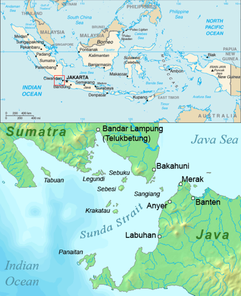
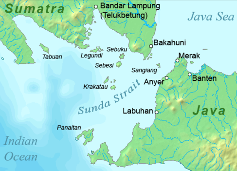
The Krakatoa Archipelago is a small uninhabited archipelago of volcanic islands formed by the Krakatoa stratovolcano located in the Sunda Strait, nestled between the much larger islands of Java and Sumatra. As of 2018, the archipelago consists of four main islands: Verlaten (aka Sertung), Lang (aka Rakata Kecil, or Panjang), Rakata, and the currently volcanically active Anak Krakatoa. Together, the islands are a part of the Indonesian island arc system, created by the northeastward subduction of the Indo-Australian Plate. As part of a dynamic volcanic system, the islands have been continuously reshaped throughout recorded history, most notably in the 1883 eruption of Krakatoa. Politically, the Krakatoa Archipelago lies entirely within Lampung province of Indonesia, and forms a part of Ujung Kulon National Park. Geology Krakatoa is an active stratovolcano located in Indonesia, and lying on the far western rim of the Pacific Ring of Fire. Krakatoa is a notably powe ... [...More Info...] [...Related Items...] OR: [Wikipedia] [Google] [Baidu] |
Anak Krakatoa
Anak Krakatoa ( id, Anak Krakatau)English translation and common name: ''Child of Krakatoa'' is a volcanic island in Indonesia. On 29 December 1927, Anak Krakatoa first emerged from the caldera formed in 1883 by the explosive volcanic eruption that destroyed the island of Krakatoa. There has been sporadic eruptive activity at the site since the late 20th century, culminating with a large underwater collapse of the volcano that caused a deadly Tsunami in December 2018. There has been subsequent activity since. Due to its young age, the island is one of several in the area that are of interest to, and the subject of extensive study by, volcanologists. History Background After the cataclysmic eruption of Krakatoa in 1883, Krakatoa Island lost approximately two-thirds of its body on the northwest side, obliterating the peaks of Perbuwatan and Danan, and leaving only the southern half of the island, including the Rakata volcano, as the last remnant of the original island. The ... [...More Info...] [...Related Items...] OR: [Wikipedia] [Google] [Baidu] |
Krakatoa Map
Krakatoa (), also transcribed (), is a caldera in the Sunda Strait between the islands of Java and Sumatra in the Indonesian province of Lampung. The caldera is part of a volcanic island group (Krakatoa archipelago) comprising four islands. Two, Lang and Verlaten, are remnants of a previous volcanic edifice destroyed in eruptions long before the famous 1883 eruption; another, Rakata, is the remnant of a much larger island destroyed in the 1883 eruption. In 1927, a fourth island, Anak Krakatoa, or "Child of Krakatoa", emerged from the caldera formed in 1883. There has been new eruptive activity since the late 20th century, with a large collapse causing a deadly tsunami in December 2018. Historical significance The most notable eruptions of Krakatoa culminated in a series of massive explosions over 26–27 August 1883, which were among the most violent volcanic events in recorded history. With an estimated Volcanic Explosivity Index (VEI) of 6, the eruption was equival ... [...More Info...] [...Related Items...] OR: [Wikipedia] [Google] [Baidu] |
Subduction Volcanoes
Subduction is a geological process in which the oceanic lithosphere is recycled into the Earth's mantle at convergent boundaries. Where the oceanic lithosphere of a tectonic plate converges with the less dense lithosphere of a second plate, the heavier plate dives beneath the second plate and sinks into the mantle. A region where this process occurs is known as a subduction zone, and its surface expression is known as an arc-trench complex. The process of subduction has created most of the Earth's continental crust. Rates of subduction are typically measured in centimeters per year, with the average rate of convergence being approximately two to eight centimeters per year along most plate boundaries. Subduction is possible because the cold oceanic lithosphere is slightly denser than the underlying asthenosphere, the hot, ductile layer in the upper mantle underlying the cold, rigid lithosphere. Once initiated, stable subduction is driven mostly by the negative buoyancy of th ... [...More Info...] [...Related Items...] OR: [Wikipedia] [Google] [Baidu] |
Active Volcanoes Of Indonesia
Active may refer to: Music * ''Active'' (album), a 1992 album by Casiopea * Active Records, a record label Ships * ''Active'' (ship), several commercial ships by that name * HMS ''Active'', the name of various ships of the British Royal Navy * USCS ''Active'', a US Coast Survey ship in commission from 1852 to 1861 * USCGC ''Active'', the name of various ships of the US Coast Guard * USRC ''Active'', the name of various ships of the US Revenue Cutter Service * USS ''Active'', the name of various ships of the US Navy Computers and electronics * Active Enterprises, a defunct video game developer * Sky Active, the brand name for interactive features on Sky Digital available in the UK and Ireland * Active (software), software used for open publishing by Indymedia; see Independent Media Center Sciences * Thermodynamic activity, measure of an effective concentration of a species in a mixture. * Activation, in chemistry the process whereby something is prepared for a s ... [...More Info...] [...Related Items...] OR: [Wikipedia] [Google] [Baidu] |
Sebesi
Sebesi (also Sebeezee, or 'Bleezie') is an Indonesian island in the Sunda Strait, between Java and Sumatra, and part of the province of Lampung. It rises to a height of and lies about north of the Krakatoa Archipelago; it is the closest large island to Krakatoa, about the same area and height as the remnant of Rakata. Like Krakatoa, it too is volcanic, although there are no dated eruptions known. (A single report of an eruption in 1680 seems to be a confusion with the Krakatoa eruption reported from that year.) Unlike the Krakatoa Archipelago, Sebesi has permanent streams and is inhabited. Habitation is concentrated most heavily on the northern and eastern coasts of the island. Sebesi was devastated during the 1883 volcanic eruption of Krakatoa. Official records give approximately 3,000 people killed, with 1,000 of these being 'non-residents'. By 1890, Sebesi was being re-cleared. It is believed that since it lies closer to Sumatra, it has served as a 'stepping stone' for ... [...More Info...] [...Related Items...] OR: [Wikipedia] [Google] [Baidu] |
Poles
Poles,, ; singular masculine: ''Polak'', singular feminine: ''Polka'' or Polish people, are a West Slavic nation and ethnic group, who share a common history, culture, the Polish language and are identified with the country of Poland in Central Europe. The preamble to the Constitution of the Republic of Poland defines the Polish nation as comprising all the citizens of Poland, regardless of heritage or ethnicity. The majority of Poles adhere to Roman Catholicism. The population of self-declared Poles in Poland is estimated at 37,394,000 out of an overall population of 38,512,000 (based on the 2011 census), of whom 36,522,000 declared Polish alone. A wide-ranging Polish diaspora (the '' Polonia'') exists throughout Europe, the Americas, and in Australasia. Today, the largest urban concentrations of Poles are within the Warsaw and Silesian metropolitan areas. Ethnic Poles are considered to be the descendants of the ancient West Slavic Lechites and other tribes that inhabit ... [...More Info...] [...Related Items...] OR: [Wikipedia] [Google] [Baidu] |
Lava Dome
In volcanology, a lava dome is a circular mound-shaped protrusion resulting from the slow extrusion of viscous lava from a volcano. Dome-building eruptions are common, particularly in convergent plate boundary settings. Around 6% of eruptions on Earth are lava dome forming. The geochemistry of lava domes can vary from basalt (e.g. Semeru, 1946) to rhyolite (e.g. Chaiten, 2010) although the majority are of intermediate composition (such as Santiaguito, dacite-andesite, present day) The characteristic dome shape is attributed to high viscosity that prevents the lava from flowing very far. This high viscosity can be obtained in two ways: by high levels of silica in the magma, or by degassing of fluid magma. Since viscous basaltic and andesitic domes weather fast and easily break apart by further input of fluid lava, most of the preserved domes have high silica content and consist of rhyolite or dacite. Existence of lava domes has been suggested for some domed structures ... [...More Info...] [...Related Items...] OR: [Wikipedia] [Google] [Baidu] |
Dike (geology)
A dike or dyke, in geological usage, is a sheet of rock that is formed in a fracture of a pre-existing rock body. Dikes can be either magmatic or sedimentary in origin. Magmatic dikes form when magma flows into a crack then solidifies as a sheet intrusion, either cutting across layers of rock or through a contiguous mass of rock. Clastic dikes are formed when sediment fills a pre-existing crack.Essentials of Geology, 3rd Ed, Stephen Marshak Magmatic dikes A magmatic dike is a sheet of igneous rock that cuts across older rock beds. It is formed when magma fills a fracture in the older beds and then cools and solidifies. The dike rock is usually more resistant to weathering than the surrounding rock, so that erosion exposes the dike as a natural wall or ridge. It is from these natural walls that dikes get their name. Dikes preserve a record of the fissures through which most mafic magma (fluid magma low in silica) reaches the surface. They are studied by geologists for the cl ... [...More Info...] [...Related Items...] OR: [Wikipedia] [Google] [Baidu] |
Perboewatan
Perboewatan (also spelled Perbuatan; apparently a Malay word of uncertain derivation) was one of the three main volcanic cones (the others being Danan and Rakata) on the island of Krakatoa (or Krakatau), in the Sunda Strait, in Indonesia. It was the lowest (400 ft) and northernmost of the cones. Perboewatan was completely destroyed during the 1883 eruption; the caldera is approximately deep at its former location. Form Photographed on May 27, 1883 by visitors to the island, Perboewatan is the only cone on Krakatoa of which quality pre-1883 photographs exist. In the photos, it appears to be a low hill with a flat top. Climbers reported the erupting crater to be about across at the top, narrowing to at the bottom and 500–800 ft deep. Samples were collected, revealing upon analysis a silica (SiO2) content of 65%. Eruptions 1680–81 In February 1681, two individuals traveling through the Straits witnessed the eruption of Krakatoa. Johann Wilhelm Vogel, a mining assayer, was tol ... [...More Info...] [...Related Items...] OR: [Wikipedia] [Google] [Baidu] |
Danan (volcano)
Danan (uncertain derivation) was one of the three volcanic cones (the others being Perboewatan and Rakata) on the island of Krakatoa, in the Sunda Strait, in Indonesia. It stood , lay in the central area of the island, and may have been a twin volcano. Danan was almost entirely destroyed in the 1883 eruption of Krakatoa; only a rocky islet named Bootsmansrots remains of it. Form Not much can be found about Danan; the interior of Krakatoa was little explored or surveyed. There were several peaks, and Verbeek surmised that it formed a "ring-shaped crater wall". In one of the photographs of Perboewatan erupting in May 1883, Danan's irregular shape can be seen in the background, partially obscured by the ash cloud arising from Perboewatan. Eruptions 1680–1681 eruption Danan apparently joined Perboewatan in eruption sometime after May 1680, when Perboewatan started erupting. A returning Dutch traveler saw both cones erupting in February 1681. The 1883 eruption {{main, 1883 e ... [...More Info...] [...Related Items...] OR: [Wikipedia] [Google] [Baidu] |
Brackish Water
Brackish water, sometimes termed brack water, is water occurring in a natural environment that has more salinity than freshwater, but not as much as seawater. It may result from mixing seawater (salt water) and fresh water together, as in estuaries, or it may occur in brackish fossil aquifers. The word comes from the Middle Dutch root '' brak''. Certain human activities can produce brackish water, in particular civil engineering projects such as dikes and the flooding of coastal marshland to produce brackish water pools for freshwater prawn farming. Brackish water is also the primary waste product of the salinity gradient power process. Because brackish water is hostile to the growth of most terrestrial plant species, without appropriate management it is damaging to the environment (see article on shrimp farms). Technically, brackish water contains between 0.5 and 30 grams of salt per litre—more often expressed as 0.5 to 30 parts per thousand (‰), which is a specific ... [...More Info...] [...Related Items...] OR: [Wikipedia] [Google] [Baidu] |


