|
Kit Hill
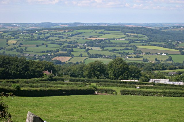
Kit Hill ( kw, Bre Skowl), at 334 metres high, dominates the area between Callington and the River Tamar in southeast Cornwall, England, UK. The word 'Kit' comes from Old English for kite, a reference to birds of prey (and not specifically the red kite). Buzzards and sparrowhawks can still be seen on the hill. It is one of five Marilyn hills in Cornwall, the four others are Watch Croft, Brown Willy, Carnmenellis and Hensbarrow Beacon. Geography Kit Hill Country Park (which includes the hill and surrounding areas), was given to the people of Cornwall in 1985 to mark the birth of Prince William, by his father, the Duke of Cornwall (Prince Charles). It is managed by Cornwall Council,Exploring Cornish Mines - Vol. 4. and consists of some 400 acres (152 hectares), making it the most dominant landscape feature in East Cornwall. Kit Hill is the highest point in the Tamar Valley Area of Outstanding Natural Beauty. The hill was formed in the same way as nearby Bodmin Moor by the intr ... [...More Info...] [...Related Items...] OR: [Wikipedia] [Google] [Baidu] |
Marilyn (geography)
This is a list of Marilyn hills and mountains in the United Kingdom, Isle of Man and Ireland by height. Marilyns are defined as peaks with a prominence of or more, regardless of height or any other merit (e.g. topographic isolation, as used in Munros). Thus, Marilyns can be mountains, with a height above , or relatively small hills. there were 2,011 recorded Marilyns. Definition The Marilyn classification was created by Alan Dawson in his 1992 book ''The Relative Hills of Britain''. The name Marilyn was coined by Dawson as a punning contrast to the ''Munro'' classification of Scottish mountains above , but which has no explicit prominence threshold, being homophonous with (Marilyn) '' Monroe''. The list of Marilyns was extended to Ireland by Clem Clements. Marilyn was the first of several subsequent British Isles classifications that rely solely on prominence, including the P600s, the HuMPs, and the TuMPs. Topographic prominence is a more difficult to estimate than to ... [...More Info...] [...Related Items...] OR: [Wikipedia] [Google] [Baidu] |
Prince William
William, Prince of Wales, (William Arthur Philip Louis; born 21 June 1982) is the heir apparent to the British throne. He is the elder son of King Charles III and his first wife Diana, Princess of Wales. Born in London, William was educated at Wetherby School, Ludgrove School and Eton College. He earned a Scottish Master of Arts degree in geography at the University of St Andrews. William then trained at Royal Military Academy Sandhurst prior to serving with the Blues and Royals. In April 2008, William graduated from Royal Air Force College Cranwell, joining RAF Search and Rescue Force in early 2009. He served as a full-time pilot with the East Anglian Air Ambulance for two years, starting in July 2015. William performs official duties and engagements on behalf of the King. He holds patronage with over 30 charitable and military organisations, including the Tusk Trust, Centrepoint, and London's Air Ambulance Charity. He undertakes projects through The Royal Foundation, w ... [...More Info...] [...Related Items...] OR: [Wikipedia] [Google] [Baidu] |
Sir John Call, 1st Baronet
Sir John Call, 1st Baronet (30 June 1731 – 1 March 1801) was an English engineer and baronet. He was born at Fenny Park, Tiverton, Devon, educated at Blundell's School and went to India at the age of 17 with Benjamin Robins, the chief engineer and captain-general of artillery in the East India Company's settlements. After the death of Robins, Call became engineer-in-chief, and eventually chief engineer with a seat on the Governor's Council. Robert Clive strongly recommended Call for the Governorship of Madras, but he had to return to England on the death of his father on 31 December 1766. On his return, he became High Sheriff of Cornwall for 1771–72 and was elected MP for Callington in 1784, a seat he held until his death. In 1784 he also became a partner in the Pybus and Son banking house and was created the 1st Baronet Call in 1791. Call built Whiteford House near Stoke Climsland, Cornwall (demolished in 1913) and the nearby folly, Whiteford Temple, now owned by the Landm ... [...More Info...] [...Related Items...] OR: [Wikipedia] [Google] [Baidu] |
Redoubt
A redoubt (historically redout) is a fort or fort system usually consisting of an enclosed defensive emplacement outside a larger fort, usually relying on earthworks, although some are constructed of stone or brick. It is meant to protect soldiers outside the main defensive line and can be a permanent structure or a hastily constructed temporary fortification. The word means "a place of retreat". Redoubts were a component of the military strategies of most European empires during the colonial era, especially in the outer works of Vauban-style fortresses made popular during the 17th century, although the concept of redoubts has existed since medieval times. A redoubt differs from a redan in that the redan is open in the rear, whereas the redoubt was considered an enclosed work. The advent of mobile warfare in the 20th century diminished the importance of stationary defence positions and siege warfare. Historically important redoubts English Civil War During the English Civ ... [...More Info...] [...Related Items...] OR: [Wikipedia] [Google] [Baidu] |
English Civil War
The English Civil War (1642–1651) was a series of civil wars and political machinations between Parliamentarians (" Roundheads") and Royalists led by Charles I ("Cavaliers"), mainly over the manner of England's governance and issues of religious freedom. It was part of the wider Wars of the Three Kingdoms. The first (1642–1646) and second (1648–1649) wars pitted the supporters of King Charles I against the supporters of the Long Parliament, while the third (1649–1651) saw fighting between supporters of King Charles II and supporters of the Rump Parliament. The wars also involved the Scottish Covenanters and Irish Confederates. The war ended with Parliamentarian victory at the Battle of Worcester on 3 September 1651. Unlike other civil wars in England, which were mainly fought over who should rule, these conflicts were also concerned with how the three Kingdoms of England, Scotland and Ireland should be governed. The outcome was threefold: the trial of and ... [...More Info...] [...Related Items...] OR: [Wikipedia] [Google] [Baidu] |
Dartmoor
Dartmoor is an upland area in southern Devon, England. The moorland and surrounding land has been protected by National Park status since 1951. Dartmoor National Park covers . The granite which forms the uplands dates from the Carboniferous Period of geological history. The landscape consists of moorland capped with many exposed granite hilltops known as tors, providing habitats for Dartmoor wildlife. The highest point is High Willhays, above sea level. The entire area is rich in antiquities and archaeology. Dartmoor National Park is managed by the Dartmoor National Park Authority, whose 22 members are drawn from Devon County Council, local district councils and Government. Parts of Dartmoor have been used as military firing ranges for over 200 years. The public is granted extensive land access rights on Dartmoor (including restricted access to the firing ranges) and it is a popular tourist destination. Physical geography Geology Dartmoor includes the largest area of ... [...More Info...] [...Related Items...] OR: [Wikipedia] [Google] [Baidu] |
Hingston Down
Hingston Down is a hill not far from Gunnislake in Cornwall, England, United Kingdom. It is the subject of an old rhyme, due to the prolific tin mining that formerly took place in the area: This Hingston Down should not be confused with the Hingston Down at , a hill spur about a mile east of the town of Moretonhampstead in the neighbouring county of Devon. History The hill is usually accepted as the place mentioned in an entry in the '' Anglo-Saxon Chronicle'' for 835 (corrected by scholars to 838) which says that Egbert king of the West Saxons defeated an army of Vikings and Cornish at the Battle of Hingston Down (''Hengestdūn'' = "Stallion Hill"). Geology The Hingston Down Consols mine on the hill is the type locality for the mineral Arthurite, which was discovered here. There is also a quarry on the hill, which forms the Hingston Down Quarry & Consols Site of Special Scientific Interest, noted for its mineralisation. See also *Kit Hill Country Park Kit Hill ( ... [...More Info...] [...Related Items...] OR: [Wikipedia] [Google] [Baidu] |
Sedimentary Rock
Sedimentary rocks are types of rock that are formed by the accumulation or deposition of mineral or organic particles at Earth's surface, followed by cementation. Sedimentation is the collective name for processes that cause these particles to settle in place. The particles that form a sedimentary rock are called sediment, and may be composed of geological detritus (minerals) or biological detritus (organic matter). The geological detritus originated from weathering and erosion of existing rocks, or from the solidification of molten lava blobs erupted by volcanoes. The geological detritus is transported to the place of deposition by water, wind, ice or mass movement, which are called agents of denudation. Biological detritus was formed by bodies and parts (mainly shells) of dead aquatic organisms, as well as their fecal mass, suspended in water and slowly piling up on the floor of water bodies (marine snow). Sedimentation may also occur as dissolved minerals precipitate from ... [...More Info...] [...Related Items...] OR: [Wikipedia] [Google] [Baidu] |
Magma
Magma () is the molten or semi-molten natural material from which all igneous rocks are formed. Magma is found beneath the surface of the Earth, and evidence of magmatism has also been discovered on other terrestrial planets and some natural satellites. Besides molten rock, magma may also contain suspended crystals and gas bubbles. Magma is produced by melting of the mantle or the crust in various tectonic settings, which on Earth include subduction zones, continental rift zones, mid-ocean ridges and hotspots. Mantle and crustal melts migrate upwards through the crust where they are thought to be stored in magma chambers or trans-crustal crystal-rich mush zones. During magma's storage in the crust, its composition may be modified by fractional crystallization, contamination with crustal melts, magma mixing, and degassing. Following its ascent through the crust, magma may feed a volcano and be extruded as lava, or it may solidify underground to form an intrusion, such as a ... [...More Info...] [...Related Items...] OR: [Wikipedia] [Google] [Baidu] |
Bodmin Moor
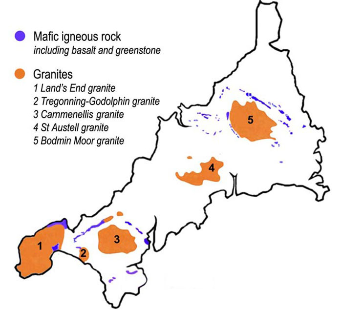
Bodmin Moor ( kw, Goon Brenn) is a granite moorland in north-eastern Cornwall, England. It is in size, and dates from the Carboniferous period of geological history. It includes Brown Willy, the highest point in Cornwall, and Rough Tor, a slightly lower peak. Many of Cornwall's rivers have their sources here. It has been inhabited since at least the Neolithic era, when primitive farmers started clearing trees and farming the land. They left their megalithic monuments, hut circles and cairns, and the Bronze Age culture that followed left further cairns, and more stone circles and stone rows. By medieval and modern times, nearly all the forest was gone and livestock rearing predominated. The name Bodmin Moor is relatively recent. An early mention is in the ''Royal Cornwall Gazette'' of 28 November 1812. The upland area was formerly known as Fowey Moor after the River Fowey, which rises within it. Geology Bodmin Moor is one of five granite plutons in Cornwall that make up pa ... [...More Info...] [...Related Items...] OR: [Wikipedia] [Google] [Baidu] |
Area Of Outstanding Natural Beauty
An Area of Outstanding Natural Beauty (AONB; , AHNE) is an area of countryside in England, Wales, and Northern Ireland, that has been designated for conservation due to its significant landscape value. Areas are designated in recognition of their national importance by the relevant public body: Natural England, Natural Resources Wales, and the Northern Ireland Environment Agency respectively. In place of AONB, Scotland uses the similar national scenic area (NSA) designation. Areas of Outstanding Natural Beauty enjoy levels of protection from development similar to those of UK national parks, but unlike national parks the responsible bodies do not have their own planning powers. They also differ from national parks in their more limited opportunities for extensive outdoor recreation. History The idea for what would eventually become the AONB designation was first put forward by John Dower in his 1945 ''Report to the Government on National Parks in England and Wales''. Dower ... [...More Info...] [...Related Items...] OR: [Wikipedia] [Google] [Baidu] |
Tamar Valley, England
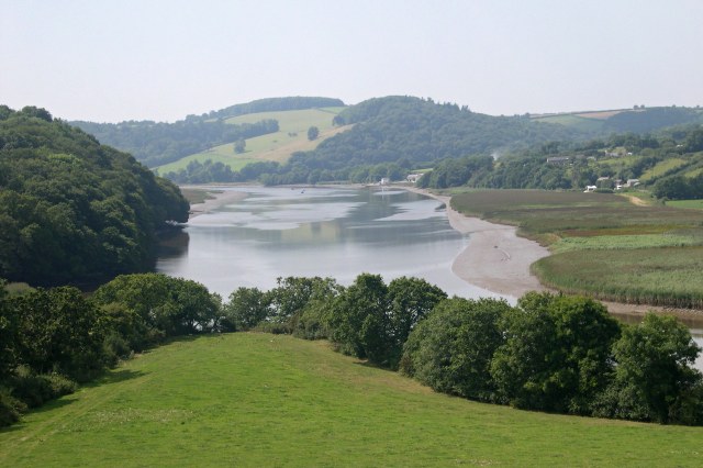
The Tamar (; kw, Dowr Tamar) is a river in south west England, that forms most of the border between Devon (to the east) and Cornwall (to the west). A part of the Tamar Valley is a World Heritage Site due to its historic mining activities. The Tamar's source is less than from the north Cornish coast, but it flows southward and its course runs across the peninsula to the south coast. The total length of the river is . At its mouth, the Tamar flows into the Hamoaze before entering Plymouth Sound, a bay of the English Channel. Tributaries of the river include the rivers Inny, Ottery, Kensey and Lynher (or ''St Germans River'') on the Cornish side, and the Deer and Tavy on the Devon side. The name Tamar (or Tamare) was mentioned by Ptolemy in the second century in his ''Geography''. The name is said to mean "great water."Furneaux, Robert. The Tamar: A Great Little River. Ex Libris Press. 1992. Foot, Sarah. ''The River Tamar''. Bossiney Books. 1989.Neale, John. Discovering ... [...More Info...] [...Related Items...] OR: [Wikipedia] [Google] [Baidu] |

_(52344711248).jpg)
.png)


