|
Kijevo, Trnovo
Kijevo ( sr-Cyrl, Кијево) is a village in Trnovo municipality, Istočno Sarajevo, Republika Srpska, Bosnia and Herzegovina. Kijevo is south of Sarajevo on the road M-18 Sarajevo- Trnovo-Foča-Trebinje. The closest airport is Sarajevo International Airport, located 9.7 km north west of Kijevo. The Željeznica river is one of the Kijevo's chief geographic features. It flows through the town and municipality from south through the center of Trnovo, Kijevo and Istočno (East) Sarajevo to west part of Sarajevo Sarajevo ( ; cyrl, Сарајево, ; ''see Names of European cities in different languages (Q–T)#S, names in other languages'') is the Capital city, capital and largest city of Bosnia and Herzegovina, with a population of 275,524 in its a ... eventually meets up with the Bosna river. References External links Trnovo Municipality, Official WebsiteOfficial page of City of East Sarajevo {{DEFAULTSORT:Kijevo, Trnovo Populated places in Trnovo, Republika ... [...More Info...] [...Related Items...] OR: [Wikipedia] [Google] [Baidu] |
Political Divisions Of Bosnia And Herzegovina
The political divisions of Bosnia and Herzegovina were created by the Dayton Agreement. The Agreement divides the country into two federal entities: the Federation of Bosnia and Herzegovina (FBiH) and the Republika Srpska (RS) and one additional entity (condominium) named the Brčko District. The Federation of Bosnia and Herzegovina (FBiH) is composed of mostly Bosniaks and Croats, while the Republika Srpska (RS) is composed of mostly Serbs. Each entity governs roughly one half of the state's territory. The Federation of Bosnia and Herzegovina itself has a federal structure and consists of 10 autonomous cantons. Overview The Federation and the Republika Srpska governments are charged with overseeing internal functions. Each has its own government, flag and coat of arms, president, legislature, police force, customs, and postal system. The police sectors are overseen by the state-level ministry of safety affairs. Since 2005, Bosnia and Herzegovina has one set of Armed for ... [...More Info...] [...Related Items...] OR: [Wikipedia] [Google] [Baidu] |
Municipalities Of Republika Srpska
Under the "Law on Territorial Organization and Local Self-Government" adopted in 1994, Republika Srpska was divided into 80 municipalities. After the conclusion of the Dayton Peace Agreement, the law was amended in 1996 to reflect the changes to the entity's borders and now provides for the division of Republika Srpska into 64 municipalities. List of municipalities The following list includes 64 municipalities of Republika Srpska (with population data from 2013 census): Former municipalities The ''Law on Territorial Organization and Local Self-Government'' was amended in 1996 to provide that certain municipalities whose territory was now completely or partially located in the Federation of Bosnia and Herzegovina would "temporarily stop functioning." In addition, the parts of these former municipalities that were located in Republika Srpska (if any) were incorporated into other municipalities. The following are the former municipalities of Republika Srpska: *Glamoč ''(part ... [...More Info...] [...Related Items...] OR: [Wikipedia] [Google] [Baidu] |
Trnovo, Republika Srpska
Trnovo ( sr-cyr, Трново) is a municipality of the city of Istočno Sarajevo located in Republika Srpska, an entity of Bosnia and Herzegovina. As of 2013, the municipality had a population of 2,050 inhabitants. The town itself had a total population of 1,023, with 956 of them living in the Republika Srpska part and 67 in the Federation part. It consists of roughly one third of the Bosnian War, pre-war municipality of Trnovo, Bosnia and Herzegovina, Trnovo. Roughly two thirds of the pre-war Trnovo, Federation of Bosnia and Herzegovina, Trnovo municipality is now part of the Federation of Bosnia and Herzegovina entity. Geography Trnovo is situated south of Sarajevo on the M-18 road Sarajevo-Trnovo-Foča-Trebinje. It is surrounded by the Jahorina, Bjelašnica and Treskavica mountains which were the locations of Olympic competitions during the 1984 Winter Olympics. Those mountains are popular destinations for a variety of winter sports and activities. The Željeznica (Bosna), ... [...More Info...] [...Related Items...] OR: [Wikipedia] [Google] [Baidu] |
Central European Time
Central European Time (CET) is a standard time which is 1 hour ahead of Coordinated Universal Time (UTC). The time offset from UTC can be written as UTC+01:00. It is used in most parts of Europe and in a few North African countries. CET is also known as Middle European Time (MET, German: MEZ) and by colloquial names such as Amsterdam Time, Berlin Time, Brussels Time, Madrid Time, Paris Time, Rome Time, Warsaw Time or even Romance Standard Time (RST). The 15th meridian east is the central axis for UTC+01:00 in the world system of time zones. As of 2011, all member states of the European Union observe summer time (daylight saving time), from the last Sunday in March to the last Sunday in October. States within the CET area switch to Central European Summer Time (CEST, UTC+02:00) for the summer. In Africa, UTC+01:00 is called West Africa Time (WAT), where it is used by several countries, year round. Algeria, Morocco, and Tunisia also refer to it as ''Central European ... [...More Info...] [...Related Items...] OR: [Wikipedia] [Google] [Baidu] |
Central European Summer Time
Central European Summer Time (CEST), sometimes referred to as Central European Daylight Time (CEDT), is the standard clock time observed during the period of summer daylight-saving in those European countries which observe Central European Time (CET; UTC+01:00) during the other part of the year. It corresponds to UTC+02:00, which makes it the same as Eastern European Time, Central Africa Time, South African Standard Time, Egypt Standard Time and Kaliningrad Time in Russia. Names Other names which have been applied to Central European Summer Time are Middle European Summer Time (MEST), Central European Daylight Saving Time (CEDT), and Bravo Time (after the second letter of the NATO phonetic alphabet). Period of observation Since 1996, European Summer Time has been observed between 01:00 UTC (02:00 CET and 03:00 CEST) on the last Sunday of March, and 01:00 UTC on the last Sunday of October; previously the rules were not uniform across the European Union. There were proposals ... [...More Info...] [...Related Items...] OR: [Wikipedia] [Google] [Baidu] |
Sarajevo
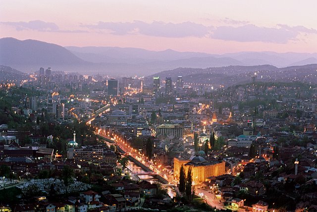
Sarajevo ( ; cyrl, Сарајево, ; ''see Names of European cities in different languages (Q–T)#S, names in other languages'') is the Capital city, capital and largest city of Bosnia and Herzegovina, with a population of 275,524 in its administrative limits. The Sarajevo metropolitan area including Sarajevo Canton, Istočno Sarajevo, East Sarajevo and nearby municipalities is home to 555,210 inhabitants. Located within the greater Sarajevo valley of Bosnia (region), Bosnia, it is surrounded by the Dinaric Alps and situated along the Miljacka River in the heart of the Balkans, a region of Southern Europe. Sarajevo is the political, financial, social and cultural center of Bosnia and Herzegovina and a prominent center of culture in the Balkans. It exerts region-wide influence in entertainment, media, fashion and the arts. Due to its long history of religious and cultural diversity, Sarajevo is sometimes called the "Jerusalem of Europe" or "Jerusalem of the Balkans". It is o ... [...More Info...] [...Related Items...] OR: [Wikipedia] [Google] [Baidu] |
Foča
Foča ( sr-Cyrl, Фоча, ) is a town and a municipality located in Republika Srpska in south-eastern Bosnia and Herzegovina, on the banks of Drina river. As of 2013, the town has a population of 12,234 inhabitants, while the municipality has 18,288 inhabitants. Foča houses some faculties (including the Medical and Orthodox Theological Faculty of Saint Basil of Ostrog) from the Istočno Sarajevo University. It is also home to the "Seminary of Saint Peter of Sarajevo and Dabar-Bosna", one of seven seminaries in the Serbian Orthodox Church. Foča was also, until 1992, home to one of Bosnia's most important Islamic high schools, the Madrasa of Mehmed Pasha Kukavica. The Sutjeska National Park, which is the oldest National Park in Bosnia and Herzegovina, is located in the municipality. History Early history The town was known as Hotča during medieval times. It was then known as a trading centre on route between Ragusa (now Dubrovnik) and Constantinople (now Istanbul, Turkey) ... [...More Info...] [...Related Items...] OR: [Wikipedia] [Google] [Baidu] |
Trebinje
Trebinje ( sr-Cyrl, Требиње, ) is a city and municipality located in the Republika Srpska entity of Bosnia and Herzegovina. It is the southernmost city in Bosnia and Herzegovina and is situated on the banks of Trebišnjica river in the region of East Herzegovina. As of 2013, it has a population of 31,433 inhabitants. The city's old town quarter dates to the 18th-century Ottoman period, and includes the Arslanagić Bridge, also known as Perovića Bridge. Geography Physical geography The city lies in the Trebišnjica river valley, at the foot of Leotar, in southeastern Herzegovina, some by road from Dubrovnik, Croatia, on the Adriatic coast. There are several mills along the river, as well as several bridges, including three in the city of Trebinje itself, as well as a historic Ottoman Arslanagić Bridge nearby. The river is heavily exploited for hydro-electric energy. After it passes through the Popovo Polje area southwest of the city, the river – which always floo ... [...More Info...] [...Related Items...] OR: [Wikipedia] [Google] [Baidu] |
Sarajevo International Airport
Sarajevo International Airport ( bs, Međunarodni aerodrom Sarajevo/Међународни аеродром Сарајево) is the main international airport in Bosnia and Herzegovina, serving Sarajevo, capital of Bosnia and Herzegovina. It is located southwest of the Sarajevo railway station and some west of downtown Sarajevo in the Ilidža municipality, suburb of Butmir. In 2019, 1,143,680 passengers travelled through the airport, compared to 323,499 in 2001. History Early years First regular flights to Sarajevo using an airfield in the suburb of Butmir begin in 1930 when the domestic airliner Aeroput opened a regular route linking Belgrade to Podgorica via Sarajevo. A year later, Aeroput opened a new route which linked Belgrade and Zagreb via Sarajevo, Split, and Rijeka. In 1935, Aeroput operated three times weekly the non-stop route Belgrade – Sarajevo, which was extended to Dubrovnik a year later. In 1937, Aeroput included regular flights linking Sarajevo to Zagreb, a ... [...More Info...] [...Related Items...] OR: [Wikipedia] [Google] [Baidu] |
Željeznica (Bosna)
The Željeznica ( sr-cyrl, Жељезница) is a river in Bosnia and Herzegovina, which rises at the foot of the Treskavica Mountain. It has a number of rapids and whirlpools, including those of Turovi. Kazani is regarded the most attractive place in the canyon, where round hollows, "kettles", give the impression of boiling water. The kettles are about half to one meter deep and 0,30 to 0,70 cm wide in radius, and they are frequent in the riverbed. The Željeznica river is one of the chief geographic features of the western Sarajevo field (Sarajevo polje). It flows through the municipalities Trnovo and Istočna Ilidža from south and eventually meets up with the Mala Bosna river, a stretch of the Bosna between its source at Vrelo Bosne and Željeznica confluence, all near Ilidža, Sarajevo. The Željeznica and the Mala Bosna form the Bosna. The Željeznica river is the western boundary of Jahorina mountain. The archaeological site of Butmir is located on the right bank o ... [...More Info...] [...Related Items...] OR: [Wikipedia] [Google] [Baidu] |
Trnovo (RS)
Trnovo ( sr-cyr, Трново) is a municipality of the city of Istočno Sarajevo located in Republika Srpska, an entity of Bosnia and Herzegovina. As of 2013, the municipality had a population of 2,050 inhabitants. The town itself had a total population of 1,023, with 956 of them living in the Republika Srpska part and 67 in the Federation part. It consists of roughly one third of the pre-war municipality of Trnovo. Roughly two thirds of the pre-war Trnovo municipality is now part of the Federation of Bosnia and Herzegovina entity. Geography Trnovo is situated south of Sarajevo on the M-18 road Sarajevo-Trnovo-Foča-Trebinje. It is surrounded by the Jahorina, Bjelašnica and Treskavica mountains which were the locations of Olympic competitions during the 1984 Winter Olympics. Those mountains are popular destinations for a variety of winter sports and activities. The Željeznica river is one of the town's chief geographic features. It flows through the town and municipality ... [...More Info...] [...Related Items...] OR: [Wikipedia] [Google] [Baidu] |


