|
Khulm
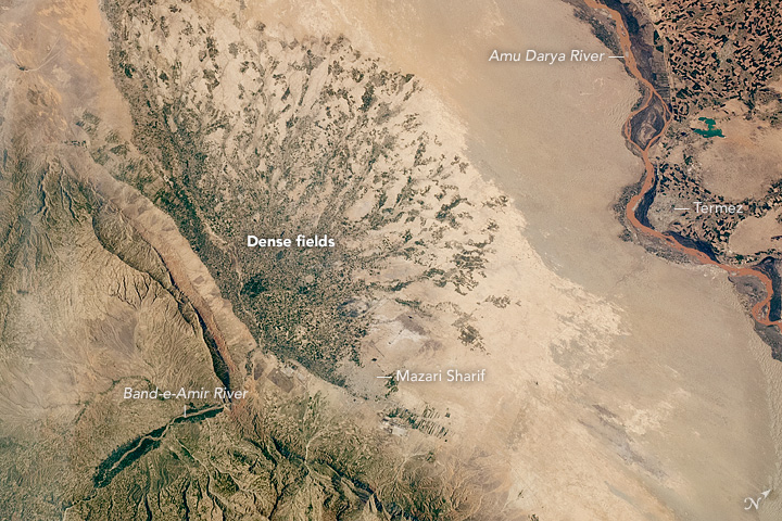
Kholm or Khulm (Dari/Pashto: خلم), formerly known as Tashqurghan (Dari/Uzbek: تاشقرغان), is a town in Balkh Province of northern Afghanistan, 60 km east of Mazar-i-Sharif one-third of the way to Kunduz. Kholm is an ancient town located on the fertile, inland delta fan of the Khulm River (Darya-i- Tashqurghan). As such, it is an agriculturally rich locale and densely populated. It is famous for its covered market, and is a centre for trading in sheep and wood. The town was once part of Samangan Province, now in the Khulm District of Balkh. Etymology The original name Tashqurghan (also romanized ''Tashkorghan'') is Uzbeki word for "stone mausoleum/kurgan". The town's name was changed to Kholm (also romanized ''Khulm'') during the Pashtunisation of northern Afghanistan by the central government headed by Minister of the Interior, Wazir Mohammad Gul Khan. History and background For many centuries Afghanistan was located on the old serais (along the Silk Road) ... [...More Info...] [...Related Items...] OR: [Wikipedia] [Google] [Baidu] |
Khulm River
The Khulm River (''Darya-i Khulm''; alternate spelling: Kholm; alternate name: Tashqurghan River) is a river of Northern-Central Afghanistan. In its lower course, it passes through Khulm and Haybak, today in Balkh Province. The Khulm is a tributary to the Oxus basin. Its source is located to the South of the city of Khulm. Further upstream, it passes through the city of Samangan and Samangan Province. The Khulm River forms the western border of Kunduz Province. Geography The mountains are characterized as rocky aridity as they extend from the Koh-i-Baba to Khulm River. On occasion, the landscape turns into trenched valleys engulfed with vegetation. The river rocks are composed of sandstone and limestone. The Khulm River is one of the tributaries of the Amu Darya River, a major river in Central Asia. It is known as a “blind river” or “natural river” as it dries up due to local use within its basin boundary and does not reach the Amu Darya, except during exceptional high ... [...More Info...] [...Related Items...] OR: [Wikipedia] [Google] [Baidu] |
Samangan Province
Samangan (Dari: ; Pashto: ) is one of the thirty-four provinces of Afghanistan, located north of the Hindu Kush mountains in the central part of the country. The province covers and is surrounded by Sar-e Pol Province in the west, Balkh in the north, Baghlan in the east, and Bamyan in the south. Samangan province is divided into 7 districts and contains 674 villages. It has a population of about 325,000ref name=nsia/> which is Multiethnic society, multi-ethnic and mostly a rural society. The city of Aybak serves as the provincial capital. In 2021, the Taliban gained control of the province during the 2021 Taliban offensive. History The earliest known history of the province is linked to the identification of the Samangan by Aoros Ptolemy as the place of the Varni or Uarni and the fortified city of Samangan on the banks of the Khulm River identical to the Bhaktria regi on the Dargydus river south east of Zariaspa. The ruins found here established the city's founding by Eukra ... [...More Info...] [...Related Items...] OR: [Wikipedia] [Google] [Baidu] |
Khulm District
Khulm or Khulmi ( prs, خُلم) (see Kholm, Afghanistan) is a district of Balkh province, Afghanistan Afghanistan, officially the Islamic Emirate of Afghanistan,; prs, امارت اسلامی افغانستان is a landlocked country located at the crossroads of Central Asia and South Asia. Referred to as the Heart of Asia, it is bordere .... Its capital lies at Kholm. In 2019 the estimated population was 81,234. District profile: * Villages: 91 * Education: 7 primary, 13 secondary, 7 high schools * Health centers: 2 basic, 2 comprehensive References External links Summary of District Development PlanJuly 2009 Districts of Balkh Province {{Balkh-geo-stub ... [...More Info...] [...Related Items...] OR: [Wikipedia] [Google] [Baidu] |
Balkh Province
Balkh (Dari: , ''Balx'') is one of the 34 provinces of Afghanistan, located in the north of the country. It is divided into 15 districts and has a population of about 1,509,183, which is multi-ethnic and mostly a Persian-speaking society. The city of Mazar-i-Sharif serves as the capital of the province. The Mazar-e Sharif International Airport and Camp Marmal sit on the eastern edge of Mazar-i-Sharif. Balkh, also called VazīrābādThename of the province is derived from the ancient city of Balkh, near the modern town. The city of Mazar-e-Sharif has been an important stop on the trade routes from the Far East to the Middle East, the Mediterranean and Europe. Home to the famous blue mosque, it was once destroyed by Genghis Khan but later rebuilt by Timur. The city of Balkh and the area of Balkh Province were considered a part of various historical regions in history including Ariana and Greater Khorasan. The province serves today as Afghanistan's second but main gateway to Ce ... [...More Info...] [...Related Items...] OR: [Wikipedia] [Google] [Baidu] |
Amu Darya
The Amu Darya, tk, Amyderýa/ uz, Amudaryo// tg, Амударё, Amudaryo ps, , tr, Ceyhun / Amu Derya grc, Ὦξος, Ôxos (also called the Amu, Amo River and historically known by its Latin language, Latin name or Greek ) is a major river in Central Asia and Afghanistan. Rising in the Pamir Mountains, north of the Hindu Kush, the Amu Darya is formed by the confluence of the Vakhsh River, Vakhsh and Panj River, Panj rivers, in the Tigrovaya Balka Nature Reserve on the border between Afghanistan and Tajikistan, and flows from there north-westwards into the South Aral Sea, southern remnants of the Aral Sea. In its upper course, the river forms part of Afghanistan's northern border with Tajikistan, Uzbekistan, and Turkmenistan. In ancient history, the river was regarded as the boundary of Greater Iran with "Turan", which roughly corresponded to present-day Central Asia.B. SpulerĀmū Daryā in Encyclopædia Iranica, online ed., 2009 The Amu Darya has a flow of about 70 cubic k ... [...More Info...] [...Related Items...] OR: [Wikipedia] [Google] [Baidu] |
Afghanistan
Afghanistan, officially the Islamic Emirate of Afghanistan,; prs, امارت اسلامی افغانستان is a landlocked country located at the crossroads of Central Asia and South Asia. Referred to as the Heart of Asia, it is bordered by Pakistan to the Durand Line, east and south, Iran to the Afghanistan–Iran border, west, Turkmenistan to the Afghanistan–Turkmenistan border, northwest, Uzbekistan to the Afghanistan–Uzbekistan border, north, Tajikistan to the Afghanistan–Tajikistan border, northeast, and China to the Afghanistan–China border, northeast and east. Occupying of land, the country is predominantly mountainous with plains Afghan Turkestan, in the north and Sistan Basin, the southwest, which are separated by the Hindu Kush mountain range. , Demographics of Afghanistan, its population is 40.2 million (officially estimated to be 32.9 million), composed mostly of ethnic Pashtuns, Tajiks, Hazaras, and Uzbeks. Kabul is the country's largest city and ser ... [...More Info...] [...Related Items...] OR: [Wikipedia] [Google] [Baidu] |
Mazar-i-Sharif
, official_name = , settlement_type = City , image_skyline = , pushpin_map = Afghanistan#Bactria#West Asia , pushpin_label = Mazar-i-Sharif , pushpin_label_position = bottom , pushpin_mapsize = , pushpin_relief = yes , pushpin_map_caption = Location in Afghanistan , coordinates = , subdivision_type = Country , subdivision_name = Afghanistan , subdivision_type1 = Province , subdivision_type2 = District , subdivision_name1 = Balkh Province , subdivision_name2 = Mazar-i-Sharif District , established_title = , established_date = , leader_title = Mayor , leader_name = Abdullhaq Khurami , area_total_km2 = , area_land_km2 ... [...More Info...] [...Related Items...] OR: [Wikipedia] [Google] [Baidu] |
Abdur Rahman Khan
Abdur Rahman Khan GCSI (Pashto/Dari: ) (between 1840 and 1844 – 1 October 1901) was Emir of Afghanistan from 1880 to his death in 1901. He is known for uniting the country after years of internal fighting and negotiation of the Durand Line Agreement with British India. Abdur Rahman Khan was the first child and only son of Mohammad Afzal Khan, and grandson of Dost Mohammad Khan, founder of the Barakzai dynasty. Abdur Rahman Khan re-established the writ of the Afghan government after the disarray that followed the second Anglo-Afghan war. He became known as ''The Iron Amir'' because his government was a military despotism. This despotism rested upon a well-appointed army and was administered through officials subservient to an inflexible will and controlled by a widespread system of espionage. The nickname, ''The Iron Amir'', is also associated due to his victory over a number of rebellions by various tribes who were led by his relatives. One source says that during his reign t ... [...More Info...] [...Related Items...] OR: [Wikipedia] [Google] [Baidu] |
Mohammed Daoud Khan
Mohammed Daoud Khan ( ps, ), also romanized as Daud Khan or Dawood Khan (18 July 1909 – 28 April 1978), was an Afghan politician and general who served as prime minister of Afghanistan from 1953 to 1963 and, as leader of the 1973 Afghan coup d'état which overthrew the monarchy, served as the first president of Afghanistan from 1973 to 1978, establishing an autocratic one-party system. Born into the Afghan royal family and addressed by the prefix "Sardar", Khan started as a provincial governor and later a military commander before being appointed as Prime Minister by his cousin, King Mohammed Zahir Shah. Having failed to persuade the King to implement a one-party system, Khan overthrew the monarchy with the backing of Afghan Army officers, and proclaimed himself the first President of the Republic of Afghanistan. Khan was known for his autocratic rule, and for his educational and progressive social reforms. Under his regime, he headed a purge of communists in the governme ... [...More Info...] [...Related Items...] OR: [Wikipedia] [Google] [Baidu] |
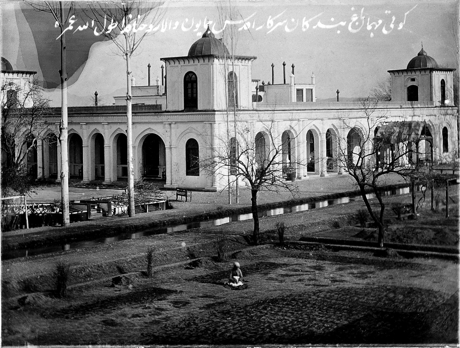
The Garden And The Pool, Tashkurgan Palace
''The'' () is a grammatical article in English, denoting persons or things already mentioned, under discussion, implied or otherwise presumed familiar to listeners, readers, or speakers. It is the definite article in English. ''The'' is the most frequently used word in the English language; studies and analyses of texts have found it to account for seven percent of all printed English-language words. It is derived from gendered articles in Old English which combined in Middle English and now has a single form used with pronouns of any gender. The word can be used with both singular and plural nouns, and with a noun that starts with any letter. This is different from many other languages, which have different forms of the definite article for different genders or numbers. Pronunciation In most dialects, "the" is pronounced as (with the voiced dental fricative followed by a schwa) when followed by a consonant sound, and as (homophone of pronoun ''thee'') when followed by a ... [...More Info...] [...Related Items...] OR: [Wikipedia] [Google] [Baidu] |
Provinces Of Afghanistan
Afghanistan is divided into 34 provinces (, '' wilåyat''). The provinces of Afghanistan are the primary administrative divisions. Each province encompasses a number of districts or usually over 1,000 villages. Provincial governors played a critical role in the reconstruction of the Afghan state following the creation of the new government under Hamid Karzai. According to international security scholar Dipali Mukhopadhyay, many of the provincial governors of the western-backed government were former warlords who were incorporated into the political system. Provinces of Afghanistan Regions of Afghanistan UN Regions Former provinces of Afghanistan During Afghanistan's history it had a number of provinces in it. It started out as just Kabul, Herat, Qandahar, and Balkh but the number of provinces increased and by 1880 the provinces consisted of Balkh, Herat, Qandahar, Ghazni, Jalalabad, and Kabul. * Southern Province – dissolved in 1964 to create Paktia Provinc ... [...More Info...] [...Related Items...] OR: [Wikipedia] [Google] [Baidu] |


.png)