|
Karnaprayag
Karnaprayag is a town and municipal board in the Chamoli District in the Indian state of Uttarakhand. Karnaprayag is one of the Panch Prayag (five confluences) of Alaknanda River, situated at the confluence of the Alaknanda and Pindar River. Demographics As of the 2001 census, Karnaprayag had a population of 6976. Males constitute 56% of the population, and females make up 44%. Karnaprayag has an average literacy rate of 76%, higher than the national average of 59.5%. Male literacy is 81%, and female literacy is 69%. 13% of the population is under six years of age. Geography Karnaprayag is located at . It has an average elevation of 860 metres (2,820 feet). The confluence of the Pindar River, which arises from the icy Pindari glacier and the Alaknanda, occurs at Karnaprayag. Nanda Devi, towering above at 7,816 m (25,634 ft.), and surrounded by an array of glittering peaks, Trisul, Drona Giri, Nanda Ghunti, Mrigathuni, and Maiktoli. Overview Karnaprayag is one of ... [...More Info...] [...Related Items...] OR: [Wikipedia] [Google] [Baidu] |
Alaknanda
The Alaknanda is a Himalayan river in the Indian state of Uttarakhand and one of the two headstreams of the Ganges, the major river of Northern India and the holy river of Hinduism. In hydrology, the Alaknanda is considered the source stream of the Ganges on account of its greater length and discharge; however, in Hindu tradition and culture, the other headstream, the Bhagirathi, is considered the source stream. Course The Alaknanda rises at the confluence and foot of the Satopanth and Bhagirath Kharak glaciers in Uttarakhand. From its origin, it travels to the village of Mana, meets with the Saraswati River, a right bank tributary, and continues downstream through narrow valleys. It reaches the Badrinath valley, arrives at Hanumanchatti, and meets with the Ghrit Ganga, a right bank tributary. From Hanumanchatti, the river goes to Pandukeshwar and flows through wide valleys and steep terrains. At Vishnuprayag it meets Dhauliganga, a left bank tributary, and travels west to th ... [...More Info...] [...Related Items...] OR: [Wikipedia] [Google] [Baidu] |
Alaknanda River
The Alaknanda is a Himalayan river in the Indian state of Uttarakhand and one of the two headstreams of the Ganges, the major river of Northern India and the holy river of Hinduism. In hydrology, the Alaknanda is considered the source stream of the Ganges on account of its greater length and discharge; however, in Hindu tradition and culture, the other headstream, the Bhagirathi, is considered the source stream. Course The Alaknanda rises at the confluence and foot of the Satopanth and Bhagirath Kharak glaciers in Uttarakhand. From its origin, it travels to the village of Mana, meets with the Saraswati River, a right bank tributary, and continues downstream through narrow valleys. It reaches the Badrinath valley, arrives at Hanumanchatti, and meets with the Ghrit Ganga, a right bank tributary. From Hanumanchatti, the river goes to Pandukeshwar and flows through wide valleys and steep terrains. At Vishnuprayag it meets Dhauliganga, a left bank tributary, and travels west to th ... [...More Info...] [...Related Items...] OR: [Wikipedia] [Google] [Baidu] |
Chamoli District
Chamoli district is a district of the Uttarakhand state of India. It is bounded by the Tibet region to the north, and by the Uttarakhand districts of Pithoragarh and Bageshwar to the east, Almora to the south, Pauri Garhwal to the southwest, Rudraprayag to the west, and Uttarkashi to the northwest. The administrative headquarters of Chamoli district is in Gopeshwar. Chamoli hosts a variety of destinations of pilgrim and tourist interest including Badrinath, Hemkund Sahib and Valley of Flowers. Chipko movement was first started in Chamoli. Etymology The word "Chamoli" is original Sanskrit Language word is "Chandramoli" (Chandra (Moon) + Moli (Wears Moon on Head) Which meaning is Lord Shiva. History The region covered by the district of Chamoli formed part of the Pauri Garhwal district till 1960. It occupies the northeastern corner of the Garhwal tract and lies in the central or mid-Himalayas in the very heart of the snowy range described in ancient books as Bahirgiri, one of ... [...More Info...] [...Related Items...] OR: [Wikipedia] [Google] [Baidu] |
Pindar River
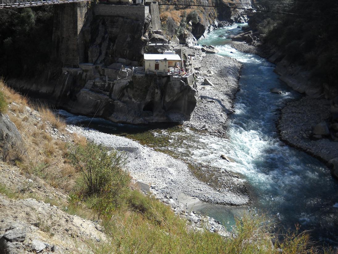
The Pindar River is a river located in Uttarakhand, India. Pindar originates from Pindari Glacier which is located in Bageshwar district of Kumaon region in Uttarakhand. The source of this river, the Pindar glacier is located at an altitude of . Pindar glacier has relatively easier access and has been documented well for its retreat over 100 years. Pindar river mouth is located at Karnaprayag where it ends by its confluence with Alaknanda River. Gallery File:Pindari glacier from Zero Point, Uttarakhand, India.jpg, Origin from Pindari Glacier File:Pindari river from Dwali, Uttarakhand, India.jpg, Pindari river from Dwali File:Karnprayag.jpg, Confluence of Alaknanda and Pindar from bottom File:HeadwatersGanges1.jpg, Pinder River (far right) in the map showing The Himalayan headwaters of the Ganges river in Uttarakhand Uttarakhand ( , or ; , ), also known as Uttaranchal ( ; the official name until 2007), is a state in the northern part of India. It is often referred to a ... [...More Info...] [...Related Items...] OR: [Wikipedia] [Google] [Baidu] |
Vishnuprayag
Vishnuprayag is one of the Panch Prayag (five confluences) of Alaknanda River, and lies at the confluence of Alaknanda River and Dhauliganga River, in Chamoli district in the Indian state of Uttarakhand. Vishnuprayag derives its name from Vishnu, According to Hindu scriptures, it is the place where Sage Narada meditated, after which Vishnu appeared before him. It is near to Kagbhusandi Lake. Geography It is located at . Its original name is Vishnuprayāg. It has an average elevation of 1,372 metres. Path The Alaknanda River, which originates in the eastern slopes of the glacier fields of Chaukhamba, is joined by the Saraswati River near Mana village and then flows in front of the Badrinath temple. It then meets the Dhauli Ganga River, which originates from the Niti Pass, to form the Vishnuprayag. This stretch of the Alaknanda River is called the Vishnu Ganga. According to legend, the sage Narada offered worship to god Vishnu at this confluence. An octagonal shaped temple l ... [...More Info...] [...Related Items...] OR: [Wikipedia] [Google] [Baidu] |
Pindari Glacier
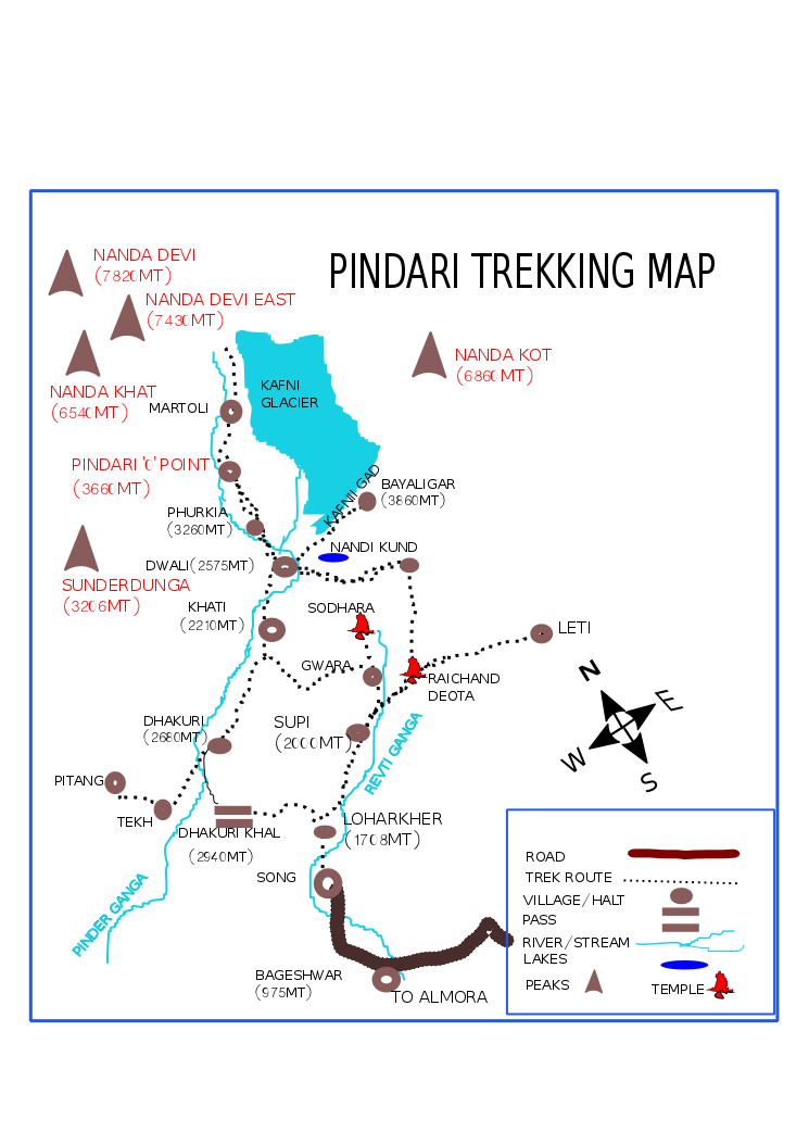
The Pindari Glacier is a glacier found in the upper reaches of the Kumaon Himalayas, to the southeast of Nanda Devi and Nanda Kot. Geography The glacier is about 9 kilometers long and gives rise to the Pindar River which meets the Alakananda at Karnaprayag in the Garhwal district. The trail to reach the glacier crosses the villages of Saung, Loharkhet, crosses over the Dhakuri Pass, continues onto Khati village (the last inhabited village on the trail), Dwali, Phurkia and finally Zero Point, Pindar, the end of the trail. Though most of the trail is along the banks of the Pindari River, the river is mostly hidden until after Khati. The Pindari Glacier trail provides for a round-trip trek that most people find comfortable to complete in 6 days. The Pindari Glacier is also famous for other adventure sports like Ice climbing and Mountain biking. Retreat Several surveys have mapped the retreat of Pindari over the years. The glacier was first surveyed by G.de P.Cotter in 190 ... [...More Info...] [...Related Items...] OR: [Wikipedia] [Google] [Baidu] |
Mahabharata
The ''Mahābhārata'' ( ; sa, महाभारतम्, ', ) is one of the two major Sanskrit epics of ancient India in Hinduism, the other being the ''Rāmāyaṇa''. It narrates the struggle between two groups of cousins in the Kurukshetra War and the fates of the Kaurava and the Pāṇḍava princes and their successors. It also contains philosophical and devotional material, such as a discussion of the four "goals of life" or ''puruṣārtha'' (12.161). Among the principal works and stories in the ''Mahābhārata'' are the '' Bhagavad Gita'', the story of Damayanti, the story of Shakuntala, the story of Pururava and Urvashi, the story of Savitri and Satyavan, the story of Kacha and Devayani, the story of Rishyasringa and an abbreviated version of the ''Rāmāyaṇa'', often considered as works in their own right. Traditionally, the authorship of the ''Mahābhārata'' is attributed to Vyāsa. There have been many attempts to unravel its historical growth and c ... [...More Info...] [...Related Items...] OR: [Wikipedia] [Google] [Baidu] |
Karna
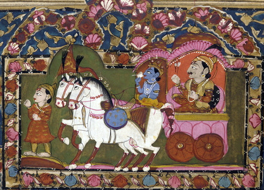
Karna (Sanskrit: कर्ण, IAST: ''Karṇa''), also known as Vasusena, Anga-raja, and Radheya, is one of the main protagonists of the Hindu epic '' Mahābhārata''. He is the son of the sun god Surya and princess Kunti (mother of the Pandavas), and thus a demigod of royal birth. Kunti was granted the boon to bear a child with desired divine qualities from the gods and without much knowledge, Kunti invoked the sun god to confirm it if it was true indeed. Karna was secretly born to an unmarried Kunti in her teenage years, fearing outrage and backlash from society over her premarital pregnancy, Kunti had no choice but to abandon the newly born Karna adrift in a basket on the Ganges, in the hope that he finds foster parents. The basket discovered and Karna is adopted and raised by foster ''Sūta'' parents named Radha and Adhiratha Nandana of the charioteer and poet profession working for king Dhritarashtra. Karna grows up to be an accomplished warrior of extraordinary abil ... [...More Info...] [...Related Items...] OR: [Wikipedia] [Google] [Baidu] |
Trisul
Trisul is a group of three Himalayan mountain peaks of western Kumaun, Uttarakhand, with the highest (Trisul I) reaching 7120m. The three peaks resemble a trident - in Sanskrit, Trishula, trident, is the weapon of Shiva. The Trishul group forms the southwest corner of the ring of peaks enclosing the Nanda Devi Sanctuary, about west-southwest of Nanda Devi itself. The main peak, Trisul I, was the first peak over to have ever been climbed, in 1907. Description of the massif and neighbouring peaks The three peaks are named Trisul I, Trisul II, and Trisul III. The massif is a north-south ridge, with Trisul I at the north end and Trisul III at the south. The massif runs roughly North-South, and hence appears compressed when viewed from the south (Ranikhet, Kausani), and more stretched out from the Southeast (Chamoli, Bedini Bugyal). Nanda Ghunti lies a few Kilometres to the northwest, while Mrigthuni is just to the southeast. Climbing history Trisul I T. G. Long ... [...More Info...] [...Related Items...] OR: [Wikipedia] [Google] [Baidu] |
Allahabad
Allahabad (), officially known as Prayagraj, also known as Ilahabad, is a metropolis in the Indian state of Uttar Pradesh.The other five cities were: Agra, Kanpur (Cawnpore), Lucknow, Meerut, and Varanasi (Benares). It is the administrative headquarters of the Allahabad district—the most populous district in the state and 13th most populous district in India—and the Allahabad division. The city is the judicial capital of Uttar Pradesh with the Allahabad High Court being the highest judicial body in the state. As of 2011, Allahabad is the seventh most populous city in the state, thirteenth in Northern India and thirty-sixth in India, with an estimated population of 1.53 million in the city. In 2011 it was ranked the world's 40th fastest-growing city. Allahabad, in 2016, was also ranked the third most liveable urban agglomeration in the state (after Noida and Lucknow) and sixteenth in the country. Hindi is the most widely spoken language in the city. Allahabad l ... [...More Info...] [...Related Items...] OR: [Wikipedia] [Google] [Baidu] |
Devprayag
Devprayag (Deva prayāga) is a town and a nagar panchayat, near New Tehri, New Tehri city in Tehri Garhwal district, Tehri Garhwal District in the state of Uttarakhand, India, and is the final one of the Panch Prayag (five confluences) of Alaknanda River where Alaknanda meets the Bhagirathi river and both rivers thereafter flow on as the Ganges river or Ganga. Overview Traditionally, it is considered to be the place where sage Dev Sharma led his ascetic life, giving birth to its present name, Devprayag. It is one of the five sacred confluences in the hills and is an important place of pilgrimage for devout Hinduism, Hindus. "Devprayag" means "Godly Confluence" in Sanskrit. According to Hindu scriptures, Devprayag is the sacred place of merging of two visible heavenly rivers, Alakananda and Bhagirathi, to form the holy Ganga. On a terrace in the upper part of the village is the temple of Raghunathji Temple, Devprayag, Raghunathji, built of huge stones, pyramidal in form, and ... [...More Info...] [...Related Items...] OR: [Wikipedia] [Google] [Baidu] |


