|
Kankai Mai
The Kankai River ( ne, कन्काई नदी, also referred to as Kankai Mai or Mai Khola) is a trans-boundary river flowing through the hills of Ilam District, Ilam and the plains of the Jhapa District in Nepal. A holy river for many Hindus living nearby, the Kotihom river bank is a common site for Indian rituals after death, death rituals. Kankai Irrigation Project, launched by the Nepalese government irrigates southern Jhapa, including Shivganj, Pachgachi and Mahavara. the Kankai River has several tourist hotspots along its course, such as in the areas of Domukha, Dhanuskoti, Chuli, Chepti and Maipokhari. The river overflows during monsoons and has potential to overflow onto the thousands of hectares of fertile plains of Jhapa. The Kotihom Surunga Municipality holds an annual Mai Mela fair on March 1, where many people from Jhapa, Morang, Ilam and various parts of India come to enjoy and perform religious activities. Kankai Aryaghat, on the Kotihom bank of the river w ... [...More Info...] [...Related Items...] OR: [Wikipedia] [Google] [Baidu] |
Nepal
Nepal (; ne, नेपाल ), formerly the Federal Democratic Republic of Nepal ( ne, सङ्घीय लोकतान्त्रिक गणतन्त्र नेपाल ), is a landlocked country in South Asia. It is mainly situated in the Himalayas, but also includes parts of the Indo-Gangetic Plain, bordering the Tibet Autonomous Region of China to the north, and India in the south, east, and west, while it is narrowly separated from Bangladesh by the Siliguri Corridor, and from Bhutan by the Indian state of Sikkim. Nepal has a diverse geography, including fertile plains, subalpine forested hills, and eight of the world's ten tallest mountains, including Mount Everest, the highest point on Earth. Nepal is a multi-ethnic, multi-lingual, multi-religious and multi-cultural state, with Nepali as the official language. Kathmandu is the nation's capital and the largest city. The name "Nepal" is first recorded in texts from the Vedic period of the India ... [...More Info...] [...Related Items...] OR: [Wikipedia] [Google] [Baidu] |
Kishanganj District
Kishanganj district is one of the thirty-eight districts of Bihar state, India, and Kishanganj town is the administrative headquarters of this district. Kishanganj district is a part of Purnia division (Seemanchal). History Kishanganj district, which was previously part of Purnia district, is part of the Mithila region. Mithila first gained prominence after being settled by Indo-Aryan peoples who established the Mithila Kingdom (also called Kingdom of the Videhas). During the late Vedic period (c. 1100–500 BCE), Kingdom of the Videhas became one of the major political and cultural centers of South Asia, along with Kuru and Pañcāla. The kings of the Kingdom of the Videhas were called Janakas. The Mithila Kingdom was later incorporated into the Vajjika League, which had its capital in the city of Vaishali, which is also in Mithila. Kishanganj was an old and important Sub-Division of Purnia district. After the long and hard struggle of around seventeen years by the people of ... [...More Info...] [...Related Items...] OR: [Wikipedia] [Google] [Baidu] |
Magh (Nepali Calendar)
Magh ( ne, माघ) is the tenth month in Bikram Sambat or B.S., the official and Hindu religious calendar of the Nepalese speaking people native to the Indian subcontinent of Hindu Nepalese nationality and ethnic Hindu Nepalis of Indian nationality. This month approximately coincides with January 15 to February 12 of the Gregorian (western) calendar and is 29 days long. Important holidays: * Magh 1, Maghe Sankranti, also see Makar Sankranti * Magh 9, Basant Panchami Vasant Panchami, also called Saraswati Puja in honor of the Hindu goddess Saraswati, is a festival that marks the preparation for the arrival of spring. The festival is celebrated in Indian religions in different ways depending on the region. ... Months in Nepali calendar External links Nepali Calendar Nepali Calendar Nepali Calendar Nepali calendar with Events and FestivalsNepali Calendar Nepali Calendar Nepali calendar {{Nepal-stub ... [...More Info...] [...Related Items...] OR: [Wikipedia] [Google] [Baidu] |
Maghe Sankranti
Maghe Sankranti (, , Nepal Bhasa: ) is a Nepali festival observed on the first of Magh in the Vikram Sambat (B.S) or Yele calendar bringing an end to the winter solstice containing month of Poush. Tharu people celebrate this particular day as new year. It is also regarded as the major government declared annual festival of the Magar community. Maghe Sankranti is similar to solstice festivals in other religious traditions. Observant Hindus take ritual baths during this festival. These include Sankhamul on the Bagmati near Patan; In the Gandaki/Narayani river basin at Triveni, Devghat near Chitwan Valley and Ridi on the Kaligandaki; and in the Koshi River basin at Dolalghat on the Sun Koshi. Festive foods like laddoo, ghee and sweet potatoes are distributed. Niece and Nephew usually go to Mama Ghar and take Tika and blessing/dakshina. Date and Significance Generally maghe sankranti falls on 14 January, and also called Makar Sankranti or Maghi in the Indian subcontinent. Mag ... [...More Info...] [...Related Items...] OR: [Wikipedia] [Google] [Baidu] |
Melā
Mela ( sa, मेला) is a Sanskrit word meaning "gathering" or "to meet" or a "fair". It is used in the Indian subcontinent for all sizes of gatherings and can be religious, commercial, cultural or sport-related. In rural traditions melas or village fairs were (and in some cases still are) of great importance. This led to their export around the world by South Asian diaspora communities wishing to bring something of that tradition to their new countries. In recent times "mela" also popularly refers to shows and exhibitions. It can be theme-based, promoting a particular culture, art or skill. Generally at "melas" people can find eateries, entertainment activities, shops and games. The Kumbh Mela, held every twelve years, at Prayagraj, Haridwar, Nashik and Ujjain is one of the largest fairs in India, where over 60 million people gathered in January 2001, making it the largest gathering anywhere in the world. Notable Melas in South Asia India * Gangasagar Mela at Sagar Isl ... [...More Info...] [...Related Items...] OR: [Wikipedia] [Google] [Baidu] |
Panchganchi
Panchganchi was a village development committee in Jhapa District in the Province No. 1 of south-eastern Nepal. At the time of the 2011 Nepal census it had a population of 16600 people living in 2207 individual households. It was later merged with Satasidham, Dharampur, and Shivaganj to form the Shivasatakshi municipality Shivasatakshi is a municipality in the southeastern part of Jhapa District in the Mechi Zone of eastern Nepal. The new municipality was formed by merging four existing VDCs— Shivaganj, Satasidham, Dharampur, and Panchgachhi—on 2 Dec 2014. T .... References Populated places in Jhapa District {{Jhapa-geo-stub ... [...More Info...] [...Related Items...] OR: [Wikipedia] [Google] [Baidu] |
Satasidham
Satasidham is a village development committee in Jhapa District in the Province No. 1 of south-eastern Nepal. At the time of the 1991 Nepal census it had a population of 20,809 people living in 3842 individual households. It was later merged with Shivaganj, Dharampur, and Panchgachhi to form the Shivasatakshi municipality Shivasatakshi is a municipality in the southeastern part of Jhapa District in the Mechi Zone of eastern Nepal. The new municipality was formed by merging four existing VDCs— Shivaganj, Satasidham, Dharampur, and Panchgachhi—on 2 Dec 2014. T .... References Populated places in Jhapa District {{Jhapa-geo-stub ... [...More Info...] [...Related Items...] OR: [Wikipedia] [Google] [Baidu] |
Alluvium
Alluvium (from Latin ''alluvius'', from ''alluere'' 'to wash against') is loose clay, silt, sand, or gravel that has been deposited by running water in a stream bed, on a floodplain, in an alluvial fan or beach, or in similar settings. Alluvium is also sometimes called alluvial deposit. Alluvium is typically geologically young and is not consolidated into solid rock. Sediments deposited underwater, in seas, estuaries, lakes, or ponds, are not described as alluvium. Floodplain alluvium can be highly fertile, and supported some of the earliest human civilizations. Definitions The present consensus is that "alluvium" refers to loose sediments of all types deposited by running water in floodplains or in alluvial fans or related landforms. However, the meaning of the term has varied considerably since it was first defined in the French dictionary of Antoine Furetière, posthumously published in 1690. Drawing upon concepts from Roman law, Furetière defined ''alluvion'' (the F ... [...More Info...] [...Related Items...] OR: [Wikipedia] [Google] [Baidu] |
Debouch
In hydrology, a debouch (or debouche) is a place where runoff from a small, confined space discharges into a larger, broader body of water. The word is derived from the French verb ''déboucher'' (), which means "to unblock, to clear". The term also has a military usage. Geology In fluvial geomorphology, a debouch is a place where runoff from a small, confined space emerges into a larger, broader space. Common examples are when a stream runs into a river or when a river runs into an ocean. Debouching can generate massive amounts of sediment transport. When a narrow stream travels down a mountain pass into a basin, an alluvial fan will form from the mass deposit of the sediment. The four largest rivers (the Amazon, the Ganges-Brahmaputra, the Yangtze and the Yellow) are responsible for 20% of the global discharge of sediment in to the oceans by debouches. Geography In fluvial geography, a debouch is a place where a body of water pours forth from a narrow opening. Some examples ar ... [...More Info...] [...Related Items...] OR: [Wikipedia] [Google] [Baidu] |
Weir
A weir or low head dam is a barrier across the width of a river that alters the flow characteristics of water and usually results in a change in the height of the river level. Weirs are also used to control the flow of water for outlets of lakes, ponds, and reservoirs. There are many weir designs, but commonly water flows freely over the top of the weir crest before cascading down to a lower level. Etymology There is no single definition as to what constitutes a weir and one English dictionary simply defines a weir as a small dam, likely originating from Middle English ''were'', Old English ''wer'', derivative of root of ''werian,'' meaning "to defend, dam". Function Commonly, weirs are used to prevent flooding, measure water discharge, and help render rivers more navigable by boat. In some locations, the terms dam and weir are synonymous, but normally there is a clear distinction made between the structures. Usually, a dam is designed specifically to impound water behind ... [...More Info...] [...Related Items...] OR: [Wikipedia] [Google] [Baidu] |
Ogee
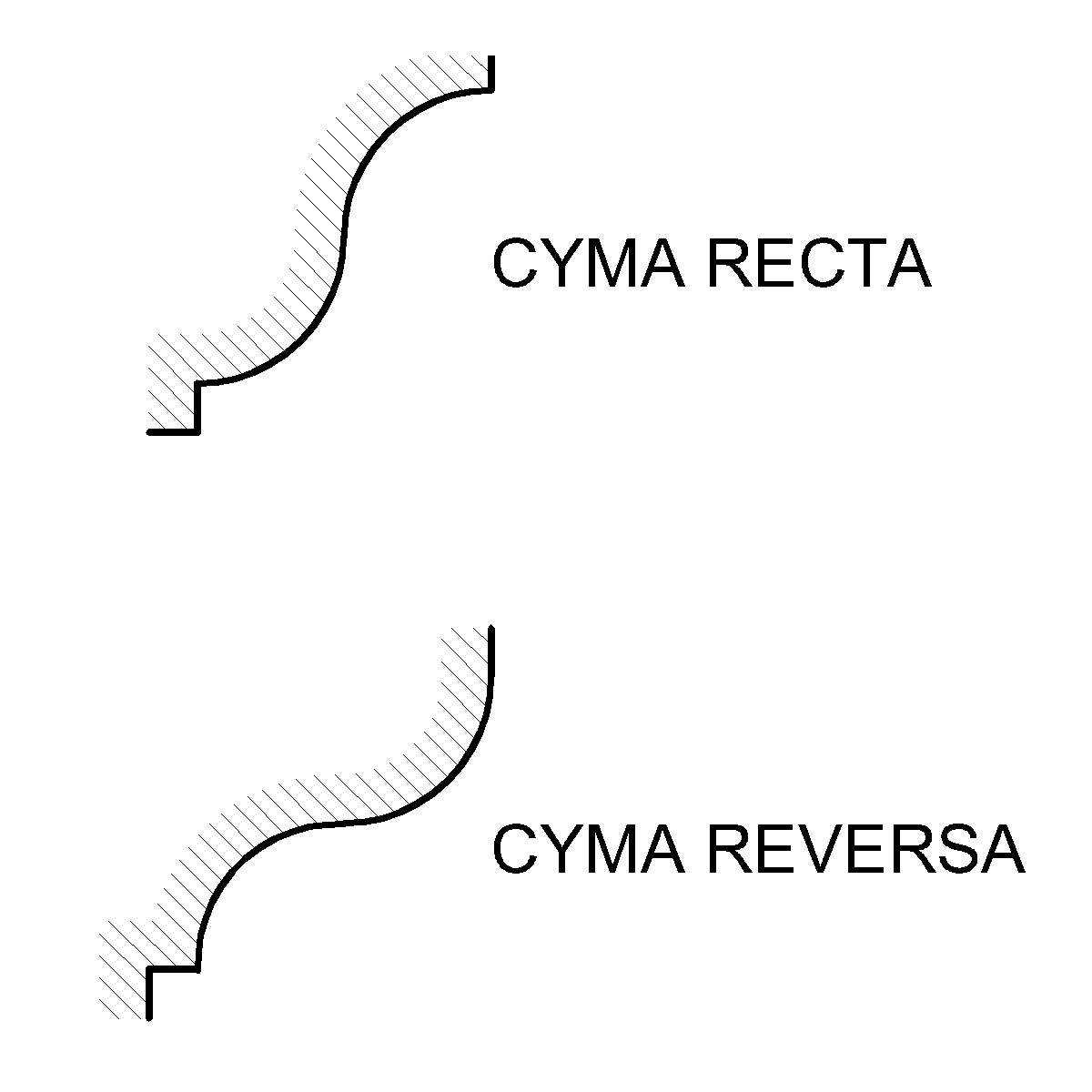
An ogee ( ) is the name given to objects, elements, and curves—often seen in architecture and building trades—that have been variously described as serpentine-, extended S-, or sigmoid-shaped. Ogees consist of a "double curve", the combination of two semicircular curves or arcs that, as a result of a point of inflection from concave to convex or ''vice versa'', have ends of the overall curve that point in opposite directions (and have tangents that are approximately parallel). First seen in textiles in the 12th century, the use of ogee elements—in particular, in the design of arches—has been said to characterise various Gothic and Gothic Revival architectural styles. The shape has many such uses in architecture from those periods to the present day, including in the ogee arch in these architectural styles, where two ogees oriented as mirror images compose the sides of the arch, and in decorative molding designs, where single ogees are common profiles (see opening image) ... [...More Info...] [...Related Items...] OR: [Wikipedia] [Google] [Baidu] |
Nepalese Rupee
The Nepalese rupee ( ne, रुपैयाँ; symbol: रु; code: NPR) is the official currency of the Federal Democratic Republic of Nepal. The Nepalese rupee is subdivided into 100 ''paisa''. The issuance of the currency is controlled by the Nepal Rastra Bank, the central bank of Nepal. The Nepalese rupee was introduced in 1932 when it replaced the Nepalese mohar at the rate 2:1. The Nepalese rupee (रु) has been pegged to the Indian rupee (₹) at the rate रु1.60 = ₹1 since 1994; prior to this, it had been pegged at the rate रु1.45 = ₹1. History The rupee was introduced in 1932, replacing the silver mohar at a rate of 2 mohar = 1 rupee. At first, the rupee was called the ''Mohru'' in Nepali. The "Bullet paisa" In 1955, 4 Paisa coins were minted, made from rifle cartridge cases from World War II that were used by the Gurkha soldiers who fought against the Imperial Japanese in the Pacific. The coins were produced by removing the primer from the cases an ... [...More Info...] [...Related Items...] OR: [Wikipedia] [Google] [Baidu] |


