|
Kamicë-Flakë
Kamicë-Flakë ( sr, Каменица) is a settlement in the former Qendër municipality, Shkodër County, northern Albania. At the 2015 local government reform it became part of the municipality Malësi e Madhe. It has a population of 957. For administrative purposes, it was grouped under the tribal region of Kastrati in the Ottoman period. Its area consists of two previously distinct settlements Kamica (alternatively known in its older form, Kamenicë) and Flaka. History The location ''Kamenica'' appears uninhabited in the Venetian cadastre of the city of Shkodra in 1416–7. It was a location of 300 acres (1.2 km2) that is described as ''partly arable, partly forest, partly used as grazing ground''. The rights of economic activity in this location belonged to the Tuzi tribe (''fis''). In the Ottoman defter of 1485 of the sanjak of Scutari the location isn't mentioned as either grazing ground or as part of a settlement. In a work of Jovan Cvijić it was recorded that in ... [...More Info...] [...Related Items...] OR: [Wikipedia] [Google] [Baidu] |
Qendër, Malësi E Madhe
Qendër is a former municipality in the Shkodër County, northwestern Albania. At the 2015 local government reform it became a subdivision of the municipality Malësi e Madhe Malësi e Madhe () is a municipality in Shkodër County, in northwestern Albania. The municipality consists of the administrative units of Gruemirë, Kastrat, Kelmend, Qendër, Shkrel with Koplik Koplik (also known as Koplik i Poshtëm) is .... The population at the 2011 census was 4,740.2011 census results Settlements There are 8 settlements within Qendër. # Bogiq # Dobër #[...More Info...] [...Related Items...] OR: [Wikipedia] [Google] [Baidu] |
Kastrati (tribe)
Kastrati is a historical Albanian tribe (''fis'') and region in northwestern Albania. It is part of the Malësia region. Administratively, the region is located in the Malësi e Madhe District, part of the Kastrati municipal unit. The centre of Kastrati is the village of Bajzë. The Kastrati tribe is known to follow the ''Kanuni i Malësisë së Madhë'', a variant of the Kanun. They are proverbally known for their pride - ''Kastrati Krenar''. Etymology The term 'Kastrati' is said to be related to the Latin word castrum', which is a Roman camp fortification. The tribe's name contains the Albanian suffix -at, widely used to form toponyms and tribal names from personal names and surnames. The clan's centre was once at the ruins of a Roman ''castra'' on the Scutari-Orosh road. Geography Kastrati tribal territory is located in northwestern Albania, near the border between Albania and Montenegro and on the eastern bank of Lake Shkodra, stretching from Bajzë in the west ... [...More Info...] [...Related Items...] OR: [Wikipedia] [Google] [Baidu] |
Serb Minority In Albania
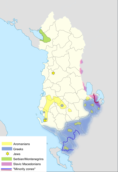
Serbs and Montenegrins (Serbs-Montenegrins) are an ethno-linguistic community in Albania. They are one of the recognized national minorities. The population was concentrated in the region of Vraka, but largely emigrated in the 1990s. The community is bilingual and by majority adhere to Eastern Orthodoxy, while a minority professes Islam. The majority of the Serbo-Montenegrin community came to Albania from Montenegro during the interwar Zogist period following 1926 and later from 1938 until 1948. In the latest census (2011) which was boycotted by Serb-Montenegrin minority organizations, 366 citizens declared themselves as Montenegrins and 142 as Serbs. According to independent monitoring, the population numbers around 2,000. Terminology The community is commonly known as Serbs-Montenegrins ( Montenegrin/ sr-Cyrl-Latn, Срби-Црногорци, Srbi-Crnogorci; sq, Serbomalazezët në Shqipëri), "Serbs" () or "Montenegrins" (). It has also been called the Serbo-Montenegrin mi ... [...More Info...] [...Related Items...] OR: [Wikipedia] [Google] [Baidu] |
Malësi E Madhe
Malësi e Madhe () is a municipality in Shkodër County, in northwestern Albania. The municipality consists of the administrative units of Gruemirë, Kastrat, Kelmend, Qendër, Shkrel with Koplik Koplik (also known as Koplik i Poshtëm) is a town and former municipality in the northwestern tip of Albania. At the 2015 local government reform, it became a subdivision, and the seat of the municipality Malësi e Madhe. It was the seat of the ... constituting its seat. As of the Institute of Statistics estimate from the 2011 census, there were 30,823 people residing in Malësi e Madhe Municipality. The area of the municipality is 951.01 km2. References External links bashkiamalesiemadhe.gov.al– Official Website {{DEFAULTSORT:Malesi e Madhe Gegëri Municipalities in Shkodër County ... [...More Info...] [...Related Items...] OR: [Wikipedia] [Google] [Baidu] |
Shkodër County
Shkodër County ( sq, Qarku i Shkodrës) is a county in northwestern Albania, with the capital in Shkodër. The county spans and had a total population of 197,177 people as of 2021. The county borders on the counties of Lezhë, Kukës and the country of Montenegro. The county consists of five municipalities: Fushë-Arrëz, Malësi e Madhe, Pukë, Shkodër and Vau i Dejës. During the Bronze Age, the area was inhabited by various Illyrian tribes such as the Ardiaeis and Labeataes. Illyria was annexed by Rome in the second century BC, becoming an integral part of the Roman Empire and its successor the Byzantine Empire. Falling under Venetian and Ottoman dominion in the late Middle Ages, the modern nation state of Albania emerged in 1912 following its independence. The climate of the county is profoundly affected by the Adriatic Sea in the west and the Albanian Alps in the north. It experiences mostly mediterranean climate, while the north enjoys continental climate. The summers ... [...More Info...] [...Related Items...] OR: [Wikipedia] [Google] [Baidu] |
Albania
Albania ( ; sq, Shqipëri or ), or , also or . officially the Republic of Albania ( sq, Republika e Shqipërisë), is a country in Southeastern Europe. It is located on the Adriatic and Ionian Seas within the Mediterranean Sea and shares land borders with Montenegro to the northwest, Kosovo to the northeast, North Macedonia to the east and Greece to the south. Tirana is its capital and largest city, followed by Durrës, Vlorë, and Shkodër. Albania displays varied climatic, geological, hydrological, and morphological conditions, defined in an area of . It possesses significant diversity with the landscape ranging from the snow-capped mountains in the Albanian Alps as well as the Korab, Skanderbeg, Pindus and Ceraunian Mountains to the hot and sunny coasts of the Albanian Adriatic and Ionian Sea along the Mediterranean Sea. Albania has been inhabited by different civilisations over time, such as the Illyrians, Thracians, Greeks, Romans, Byzantines, Venetians, and Ot ... [...More Info...] [...Related Items...] OR: [Wikipedia] [Google] [Baidu] |
Tuzi (tribe)
Tuzi ( cnr, Tuzi/Тузи, ; sq, Tuz or ''Tuzi'') is a small town in Montenegro and the seat of Tuzi Municipality, Montenegro. It is located along a main road between the city of Podgorica and the Albanian border crossing, just a few kilometers north of Lake Skadar. The Church of St. Anthony and Qazimbeg's Mosque are located in the centre of the town. Tuzi is the newest municipality in Montenegro, having been an independent municipality since 1 September 2018. Geography Tuzi is situated to the northwest of Lake Shkodra, 10 km from Podgorica, 150 km from Dubrovnik (Croatia) and 130 km to Tirana (Albania). It is surrounded by forests and mountains that are further connected with the Accursed Mountains. History The town of Tuzi is situated in Southeastern Montenegro, between Podgorica and the Skadar lake. The Albanian community of Tuzi descend from the surrounding tribes of Hoti, Gruda, Trieshi and Koja, which are part of the Malësor tribes. Tuzi was mentioned ... [...More Info...] [...Related Items...] OR: [Wikipedia] [Google] [Baidu] |
Sanjak Of Scutari
The Sanjak of Scutari or Sanjak of Shkodra ( sq, Sanxhaku i Shkodrës; sr, Скадарски санџак; tr, İskenderiye Sancağı or ''İşkodra Sancağı'') was one of the sanjaks of the Ottoman Empire. It was established after the Ottoman Empire acquired Shkodra after the siege of Shkodra in 1478–9. It was part of the Eyalet of Rumelia until 1867, when it became a part, together with the Sanjak of Skopje, of the newly established Scutari Vilayet. In 1912 and the beginning of 1913 it was occupied by members of the Balkan League during the First Balkan War. In 1914 the territory of Sanjak of Scutari became a part of the Principality of Albania, established on the basis of the peace contract signed during the London Conference in 1913. History Background and formation With short interruptions, the territory of northern Albania, including what would become the Sanjak of Scutari, belonged to the Serbian medieval states for many centuries. After the fall of the Ser ... [...More Info...] [...Related Items...] OR: [Wikipedia] [Google] [Baidu] |
Jovan Cvijić
Jovan Cvijić ( sr-cyr, Јован Цвијић, ; 1865 – 16 January 1927) was a Serbian geographer and ethnologist, president of the Serbian Royal Academy of Sciences and rector of the University of Belgrade. Cvijić is considered the founder of geography in Serbia. He began his scientific career as a geographer and geologist, and continued his activity as a human geographer and sociologist. Early life and family Cvijić was born in Loznica in the westernmost part of Principality of Serbia. His family was part of the Spasojević branch of the Piva tribe (''Pivljani'') in Old Herzegovina (currently Montenegro). Cvijić's father, Todor, was a merchant; his grandfather, Živko, was head of Loznica and a supporter of the House of Obrenović in Mačva. Živko fought in the 1844 Katana Uprising against the Defenders of the Constitution, and died after torture. Cvijić's great-grandfather, Cvijo Spasojević, patriarch of the Cvijić family, was a ''hajduk'' leader in Ol ... [...More Info...] [...Related Items...] OR: [Wikipedia] [Google] [Baidu] |
Serbs
The Serbs ( sr-Cyr, Срби, Srbi, ) are the most numerous South Slavic ethnic group native to the Balkans in Southeastern Europe, who share a common Serbian ancestry, culture, history and language. The majority of Serbs live in their nation state of Serbia, as well as in Bosnia and Herzegovina, Croatia, Montenegro, and Kosovo. They also form significant minorities in North Macedonia and Slovenia. There is a large Serb diaspora in Western Europe, and outside Europe and there are significant communities in North America and Australia. The Serbs share many cultural traits with the rest of the peoples of Southeast Europe. They are predominantly Eastern Orthodox Christians by religion. The Serbian language (a standardized version of Serbo-Croatian) is official in Serbia, co-official in Kosovo and Bosnia and Herzegovina, and is spoken by the plurality in Montenegro. Ethnology The identity of Serbs is rooted in Eastern Orthodoxy and traditions. In the 19th century, the Serbia ... [...More Info...] [...Related Items...] OR: [Wikipedia] [Google] [Baidu] |
Populated Places In Malësi E Madhe
Population typically refers to the number of people in a single area, whether it be a city or town, region, country, continent, or the world. Governments typically quantify the size of the resident population within their jurisdiction using a census, a process of collecting, analysing, compiling, and publishing data regarding a population. Perspectives of various disciplines Social sciences In sociology and population geography, population refers to a group of human beings with some predefined criterion in common, such as location, race, ethnicity, nationality, or religion. Demography is a social science which entails the statistical study of populations. Ecology In ecology, a population is a group of organisms of the same species who inhabit the same particular geographical area and are capable of interbreeding. The area of a sexual population is the area where inter-breeding is possible between any pair within the area and more probable than cross-breeding with in ... [...More Info...] [...Related Items...] OR: [Wikipedia] [Google] [Baidu] |


