|
Kaj River
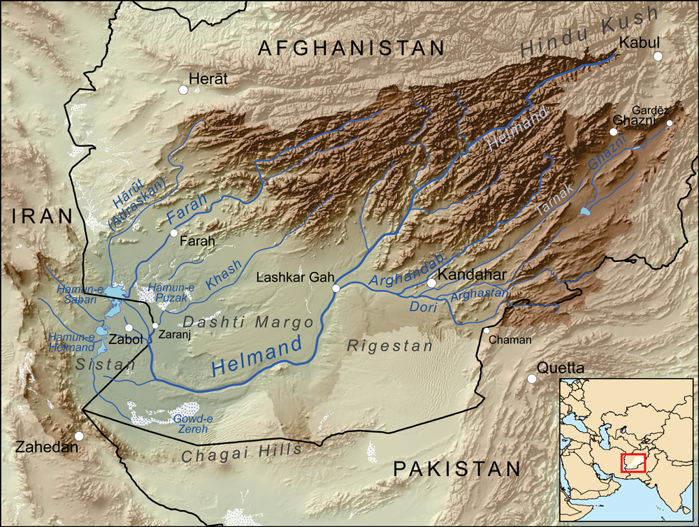
The Kaj is a river of western Afghanistan, flowing through Daykundi Province. It is a major tributary of the Helmand River. Geography The river rises in the far northern province of Daykundi Province in Daykundi District in the region called Hazarajat not far from the boundary with Bamyan Province Bamyan Province ( prs, ولایت بامیان) also spelled Bamiyan, Bāmīān or Bāmyān is one of the thirty-four provinces of Afghanistan, located in the central highlands of the Afghanistan. The terrain in Bamyan is mountainous or semi-m .... Shortly after its birth, Kaj follows a southbound direction. It ends with its confluence with the right bank in Helmand, about forty miles north of Deh Rawod. Hydrology The seasonal pattern of flow is typical of rivers in high mountains of central Afghanistan taking into account seasonal snow melt. The average annual flow or module was calculated over a period of 6 years (from 1974 to 1979) and was more or less than 35 cubic meters ... [...More Info...] [...Related Items...] OR: [Wikipedia] [Google] [Baidu] |
Afghanistan
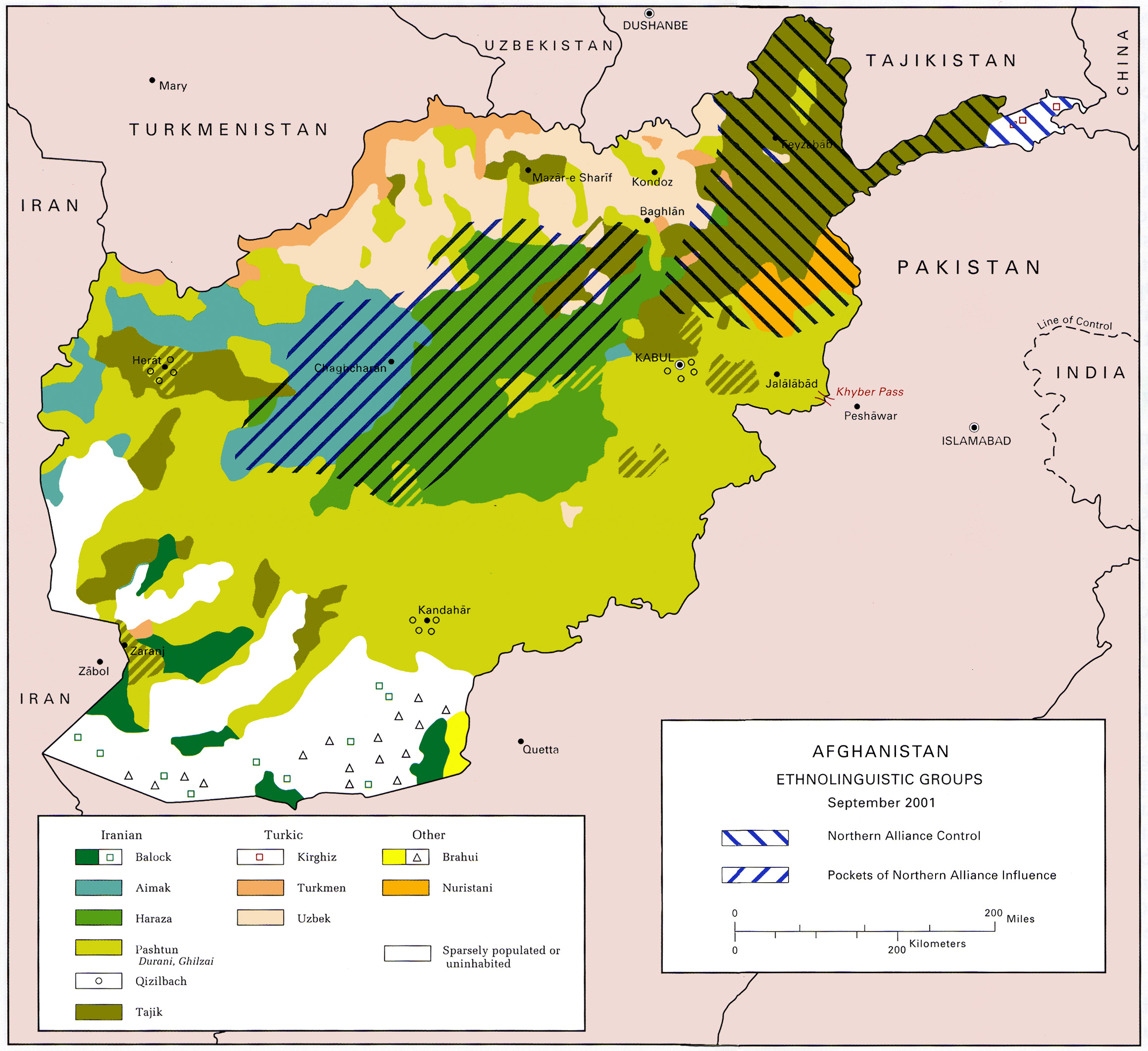
Afghanistan, officially the Islamic Emirate of Afghanistan,; prs, امارت اسلامی افغانستان is a landlocked country located at the crossroads of Central Asia and South Asia. Referred to as the Heart of Asia, it is bordered by Pakistan to the Durand Line, east and south, Iran to the Afghanistan–Iran border, west, Turkmenistan to the Afghanistan–Turkmenistan border, northwest, Uzbekistan to the Afghanistan–Uzbekistan border, north, Tajikistan to the Afghanistan–Tajikistan border, northeast, and China to the Afghanistan–China border, northeast and east. Occupying of land, the country is predominantly mountainous with plains Afghan Turkestan, in the north and Sistan Basin, the southwest, which are separated by the Hindu Kush mountain range. , Demographics of Afghanistan, its population is 40.2 million (officially estimated to be 32.9 million), composed mostly of ethnic Pashtuns, Tajiks, Hazaras, and Uzbeks. Kabul is the country's largest city and ser ... [...More Info...] [...Related Items...] OR: [Wikipedia] [Google] [Baidu] |
Daykundi Province
Daykundi ( prs, دایکندی) also spelled as Daikundi, Daykondi, Daikondi or Dai Kundi, is one of the thirty-four provinces of Afghanistan, located in the central part of the country. It has a population of about 516,504, and is a Hazara Province. Daykundi Province was carved out of the northern part of Uruzgan Province in 2004, becoming a separate province. It falls into the traditionally ethnic Hazara region known as the Hazaristan (Hazarajat) and the provincial capital is Nili. It is surrounded by Bamyan Province in the northeast, Ghazni Province in the southeast, Uruzgan Province in the south, Helmand Province in the southwest, and Ghor Province in the northwest. History Daykundi was established on March 28, 2004, when it was created from the isolated Hazara-dominated northern districts of neighboring Uruzgan Province. Development and security The province maintains its own security through the Afghan police and military. While the Government of Afghanistan, NGOs, th ... [...More Info...] [...Related Items...] OR: [Wikipedia] [Google] [Baidu] |
Helmand River
The Helmand River (also spelled Helmend, or Helmund, Hirmand; Pashto/Persian: ; Greek: ' (''Etýmandros''); Latin: ') is the longest river in Afghanistan and the primary watershed for the endorheic Sistan Basin. It emerges in the Sanglakh Range of the Hindu Kush mountains in the northeastern part of Maidan Wardak Province, where it is separated from the watershed of the Kabul River by the Unai Pass. The Helmand feeds into the Hamun Lake on the border between Afghanistan and Iran. Etymology The name comes from the Avestan ''Haētumant'', literally "dammed, having a dam", which referred to the Helmand River and the irrigated areas around it. Geography The Helmand River stretches for . It rises in the northeastern part of Maidan Wardak Province in the Hindu Kush mountains, about 40 km west of Kabul (), flowing southwestward through Daykundi Province and Uruzgan Province. After passing through the city of Lashkargah in Helmand Province, it enters the desert of Dashti Ma ... [...More Info...] [...Related Items...] OR: [Wikipedia] [Google] [Baidu] |
Daykundi District
Daykundi ( prs, دایکندی) also spelled as Daikundi, Daykondi, Daikondi or Dai Kundi, is one of the thirty-four provinces of Afghanistan, located in the central part of the country. It has a population of about 516,504, and is a Hazara Province. Daykundi Province was carved out of the northern part of Uruzgan Province in 2004, becoming a separate province. It falls into the traditionally ethnic Hazara region known as the Hazaristan (Hazarajat) and the provincial capital is Nili. It is surrounded by Bamyan Province in the northeast, Ghazni Province in the southeast, Uruzgan Province in the south, Helmand Province in the southwest, and Ghor Province in the northwest. History Daykundi was established on March 28, 2004, when it was created from the isolated Hazara-dominated northern districts of neighboring Uruzgan Province. Development and security The province maintains its own security through the Afghan police and military. While the Government of Afghanistan, NGOs, the ... [...More Info...] [...Related Items...] OR: [Wikipedia] [Google] [Baidu] |
Bamyan Province
Bamyan Province ( prs, ولایت بامیان) also spelled Bamiyan, Bāmīān or Bāmyān is one of the thirty-four provinces of Afghanistan, located in the central highlands of the Afghanistan. The terrain in Bamyan is mountainous or semi-mountainous, at the western end of the Hindu Kush mountains concurrent with the Himalayas. The province is divided into eight districts, with the town of Bamyan serving as its capital. The province has a population of about 495,557 and borders Samangan to the north, Baghlan, Parwan and Wardak to the east, Ghazni and Daykundi to the south, and Ghor and Sar-e Pol to the west. It is the largest province in the Hazarajat region of Afghanistan and is the cultural capital of the Hazara ethnic group that predominates in the area. It was a center of commerce and Buddhism in the 4th and 5th centuries. In antiquity, central Afghanistan was strategically placed to thrive from the Silk Road caravans that crisscrossed the region, trading between the ... [...More Info...] [...Related Items...] OR: [Wikipedia] [Google] [Baidu] |
Rivers Of Afghanistan
A river is a natural flowing watercourse, usually freshwater, flowing towards an ocean, sea, lake or another river. In some cases, a river flows into the ground and becomes dry at the end of its course without reaching another body of water. Small rivers can be referred to using names such as creek, brook, rivulet, and rill. There are no official definitions for the generic term river as applied to geographic features, although in some countries or communities a stream is defined by its size. Many names for small rivers are specific to geographic location; examples are "run" in some parts of the United States, "burn" in Scotland and northeast England, and "beck" in northern England. Sometimes a river is defined as being larger than a creek, but not always: the language is vague. Rivers are part of the water cycle. Water generally collects in a river from precipitation through a drainage basin from surface runoff and other sources such as groundwater recharge, springs, a ... [...More Info...] [...Related Items...] OR: [Wikipedia] [Google] [Baidu] |


