|
Joaquín Murrieta
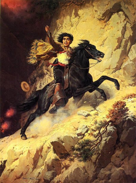
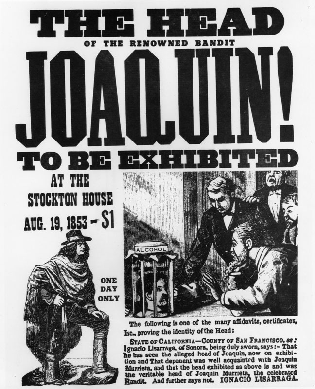
Joaquin Murrieta Carrillo (sometimes spelled Murieta or Murietta) (1829 – July 25, 1853), also called the Robin Hood of the West or the Robin Hood of El Dorado, was a Mexican-American figure of disputed historicity. The novel '' The Life and Adventures of Joaquín Murieta: The Celebrated California Bandit'' (1854) by John Rollin Ridge ostensibly recounts his story. Legends subsequently arose about a notorious outlaw in California during the California Gold Rush of the 1850s, but evidence for a historical Murrieta is scarce. Contemporary documents record testimony in 1852 concerning a minor horse thief of that name. Newspapers reported'' banditos'' named Joaquin, who robbed and killed several people during the same time. A California Ranger named Harry Love was assigned to track down Murrieta and was said to have brought his head in for the bounty. The popular legend of Joaquin Murrieta was that he was a forty-niner, a gold miner and a ''vaquero ''from Sonora. Peace loving, ... [...More Info...] [...Related Items...] OR: [Wikipedia] [Google] [Baidu] |
Major Ridge
Major Ridge, The Ridge (and sometimes Pathkiller II) (c. 1771 – 22 June 1839) (also known as ''Nunnehidihi'', and later ''Ganundalegi'') was a Cherokee leader, a member of the tribal council, and a lawmaker. As a warrior, he fought in the Cherokee–American wars against American frontiersmen. Later, Major Ridge led the Cherokee in alliances with General Andrew Jackson and the United States in the Creek and Seminole wars of the early 19th century. Along with Charles R. Hicks and James Vann, Ridge was part of the "Cherokee triumvirate," a group of rising younger chiefs in the early nineteenth-century Cherokee Nation who supported acculturation and other changes in how the people dealt with the United States. All identified as Cherokee; they were of mixed race and had some exposure to European-American culture. Ridge became a wealthy planter, slave owner, and ferryman in Georgia. Under increasing pressure for removal from the federal government, Ridge and others of the Tr ... [...More Info...] [...Related Items...] OR: [Wikipedia] [Google] [Baidu] |
Altar Desert
The Gran Desierto de Altar is one of the major sub-ecoregions of the Sonoran Desert, located in the State of Sonora, in northwest Mexico. It includes the only active erg dune region in North America. The desert extends across much of the northern border of the Gulf of California, spanning more than east to west and over north to south. It constitutes the largest continuous wilderness area within the Sonoran Desert. The eastern portion of the area contains the volcanic Pinacate Peaks region; together with the western portion, the area forms the El Pinacate y Gran Desierto de Altar Biosphere Reserve and a UNESCO World Heritage Site. Geography The Gran Desierto covers approximately , most of it in the Mexican state of Sonora. The northernmost edges reach across the international border into Organ Pipe Cactus National Monument and Cabeza Prieta National Wildlife Refuge in southwestern Arizona, United States. The region is dominated by sand sheets and dunes ranging in thickness ... [...More Info...] [...Related Items...] OR: [Wikipedia] [Google] [Baidu] |
Joaquin Murieta
Joaquin Murrieta Carrillo (sometimes spelled Murieta or Murietta) (1829 – July 25, 1853), also called the Robin Hood of the West or the Robin Hood of El Dorado, was a Mexican-American figure of disputed historicity. The novel '' The Life and Adventures of Joaquín Murieta: The Celebrated California Bandit'' (1854) by John Rollin Ridge ostensibly recounts his story. Legends subsequently arose about a notorious outlaw in California during the California Gold Rush of the 1850s, but evidence for a historical Murrieta is scarce. Contemporary documents record testimony in 1852 concerning a minor horse thief of that name. Newspapers reported'' banditos'' named Joaquin, who robbed and killed several people during the same time. A California Ranger named Harry Love was assigned to track down Murrieta and was said to have brought his head in for the bounty. The popular legend of Joaquin Murrieta was that he was a forty-niner, a gold miner and a ''vaquero ''from Sonora. Peace loving, ... [...More Info...] [...Related Items...] OR: [Wikipedia] [Google] [Baidu] |
El Salado
EL, El or el may refer to: Religion * El (deity), a Semitic word for "God" People * EL (rapper) (born 1983), stage name of Elorm Adablah, a Ghanaian rapper and sound engineer * El DeBarge, music artist * El Franco Lee (1949–2016), American politician * Ephrat Livni (born 1972), American street artist Arts, entertainment, and media Fictional entities * El, a character from the manga series ''Shugo Chara!'' by Peach-Pit * El, short for Eleven, a fictional character in the TV series ''Stranger Things'' * El, family name of Kal-El (Superman) and his father Jor-El in ''Superman'' *E.L. Faldt, character in the road comedy film ''Road Trip'' Literature * ''Él'', 1926 autobiographical novel by Mercedes Pinto * ''Él'' (visual novel), a 2000 Japanese adult visual novel Music * Él Records, an independent record label from the UK founded by Mike Alway * ''Él'' (Lucero album), a 1982 album by Lucero * "Él", Spanish song by Rubén Blades from ''Caminando'' (album) * "Él" (Luc ... [...More Info...] [...Related Items...] OR: [Wikipedia] [Google] [Baidu] |
Álamos Municipality
Álamos Municipality is a municipality in south-western Sonora, Mexico. It includes the town of Álamos. It is one of the 72 municipalities of the Mexican state of Sonora, located in the southeastern part of the state. Its municipal seat is the magical town of Álamos. Other important localities are: San Bernardo, El Mocúzarit (Conicárit), Los Tanques, among others. There are also a number of communities with the presence of Guarijíos and Mayos indigenous peoples, such as Mesa Colorada, Guajaray, Bavícora, El Paso, and Basiroa. It was decreed an independent municipality in 1813, at the same time as another large number of municipalities, in the first political division of Sonora as a state, through the Spanish Constitution of Cádiz. At that time the municipality ceased to be part of the province of Sinaloa. According to the Population and Housing Census 2020 carried out by the National Institute of Statistics and Geography The National Institute of Statistics and Geogra ... [...More Info...] [...Related Items...] OR: [Wikipedia] [Google] [Baidu] |
Sinaloa
Sinaloa (), officially the Estado Libre y Soberano de Sinaloa ( en, Free and Sovereign State of Sinaloa), is one of the 31 states which, along with Mexico City, comprise the Administrative divisions of Mexico, Federal Entities of Mexico. It is divided into Municipalities of Sinaloa, 18 municipalities and its capital city is Culiacán, Culiacán Rosales. It is located in Northwestern Mexico, and is bordered by the states of Sonora to the north, Chihuahua (state), Chihuahua and Durango to the east (separated from them by the Sierra Madre Occidental) and Nayarit to the south. To the west, Sinaloa faces Baja California Sur across the Gulf of California. The state covers an area of , and includes the Islands of Palmito Verde, Palmito de la Virgen, Altamura, Santa María, Saliaca, Macapule and San Ignacio. In addition to the capital city, the state's important cities include Mazatlán and Los Mochis. History Sinaloa belongs to the northern limit of Mesoamerica. From the Fuerte River ... [...More Info...] [...Related Items...] OR: [Wikipedia] [Google] [Baidu] |
Casanate, Álamos Municipality, Sonora
Casanate, is a village in Álamos Municipality in the Mexican state of Sonora, in northwestern Mexico. It is 48.5 kilometers south southeast of Álamos and 26.7 kilometers Northwest of El Fuerte, in Sinaloa. It lies on the left bank of the Rio Cuchujaqui at an elevation of 140 meters. Its population at the time of its last census was 69 persons, 37 males and 32 females. History Casanate, was the location of a hacienda of Rancho Tapizuelas built by the Spanish Colonel of Militias, of Real de Los Alamos, Don Francisco Julian De Alvarado after he acquired the rancho on July 1, 1748. It was one of the stops located along the route of El Camino Real through Sinaloa and Sonora between El Fuerte, Sinaloa El Fuerte () is a city and El Fuerte Municipality its surrounding municipality in the northwestern Mexican state of Sinaloa. The city population reported in the 2010 census was 12,566 people. El Fuerte, meaning "The Fort", was named a Pueblo M ... and Álamos, Sonora. [...More Info...] [...Related Items...] OR: [Wikipedia] [Google] [Baidu] |
Rio Cuchujaqui
Rio Cuchujaqui, Arroyo Cuchujaqui or Arroyo de Alamos, is a tributary river of the Fuerte River, in the Álamos Municipality of Sonora and in El Fuerte Municipality, Sinaloa, Mexico. It has its source in the Sierra de Álamos a range in the Sierra Madre Occidental in the Álamos Municipality of Sonora. Its mouth is at its confluence with the Fuerte River, just below Tehueco in Sinaloa. Its course is interrupted in Sinaloa by the Josefa Ortiz de Domínguez dam and its reservoir at built between 1964 and 1970. Much of the river's course lies in the Sierra de Álamos–Río Cuchujaqui Biosphere Reserve Sierra (Spanish for "mountain range" and "saw", from Latin '' serra'') may refer to the following: Places Mountains and mountain ranges * Sierra de Juárez, a mountain range in Baja California, Mexico * Sierra de las Nieves, a mountain range i ....UNESC0 2919. "Sierra de Alamos - Río Cuchujaqui Biosphere Reserve, Mexico". Accessed 27 August 2021/ref> References Rivers of ... [...More Info...] [...Related Items...] OR: [Wikipedia] [Google] [Baidu] |
Frank Forrest Latta
Frank Forrest Latta (1892–1983), was a California historian and ethnographer of the Yokuts people. He also wrote histories of the early European-American settlement of the San Joaquin Valley. Early life Frank Forrest Latta was the son of Presbyterian minister Eli C. Latta and teacher Harmonia Campbell, born on September 18, 1892, in Stanislaus County, near Orestimba Creek. Latta lived most of his life in the San Joaquin Valley. His father and three older brothers had come to California from Arkansas during the California Gold Rush. His father and one brother remained in California, where they were joined by his mother. One brother returned to Arkansas, and the third wrote that he was returning to Arkansas with $8,000 in gold, but disappeared without a trace. As a young boy Latta worked on several ranches in the San Joaquin Valley. He became interested in the stories of the early pioneers. In 1906, at the age of 14, he began interviewing people and gathering research regarding ea ... [...More Info...] [...Related Items...] OR: [Wikipedia] [Google] [Baidu] |


