|
Julio Ripamondi Base
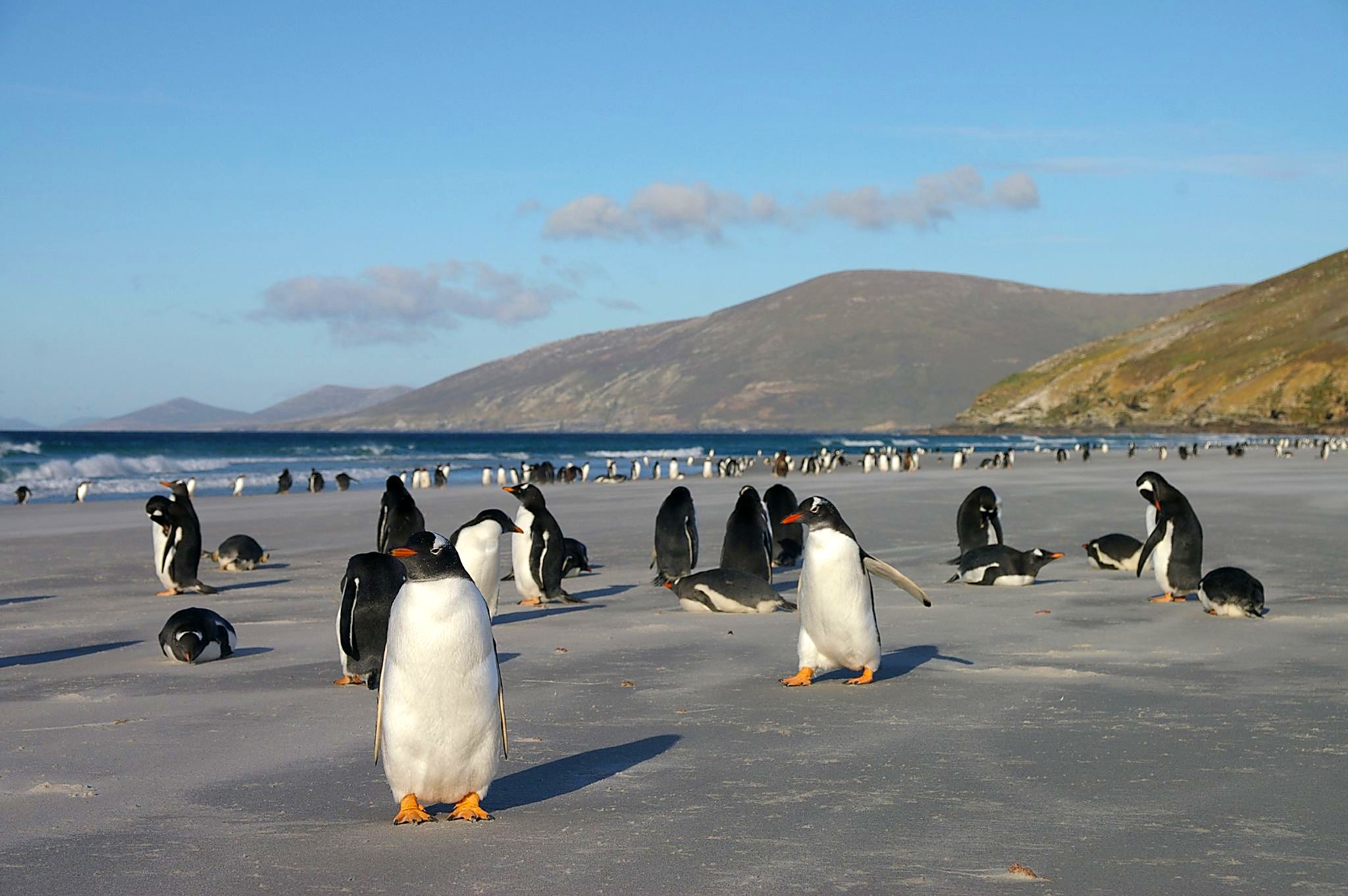
Julio Ripamonti Base is a Chilean Antarctic research base. It is located on Ardley Island in the South Shetland Islands. The base is located 50 meters above sea level, on a solid rock surface, 100 meters from the sea. Opened in 1982, it can accommodate a crew of four people. The installation consists of four modules. Julio Ripamonti is located near a colony of gentoo penguins.http://translate.googleusercontent.com/translate_c?depth=1&hl=en&prev=search&rurl=translate.google.com&sl=es&u=http://eies.ats.aq/Ats.IE/ieGenRpt.aspx%3FidParty%3D8%26period%3D1%26idYear%3D2013&usg=ALkJrhgCP7pxVrQxD_YczonewEv0DEubig See also * List of Antarctic research stations * List of Antarctic field camps Many Antarctic research stations support satellite field camps which are, in general, seasonal camps. The type of field camp can vary – some are permanent structures used during the annual Antarctic summer, whereas others are little more than te ... References Chilean Antarctic Territory ... [...More Info...] [...Related Items...] OR: [Wikipedia] [Google] [Baidu] |
Research Stations In Antarctica
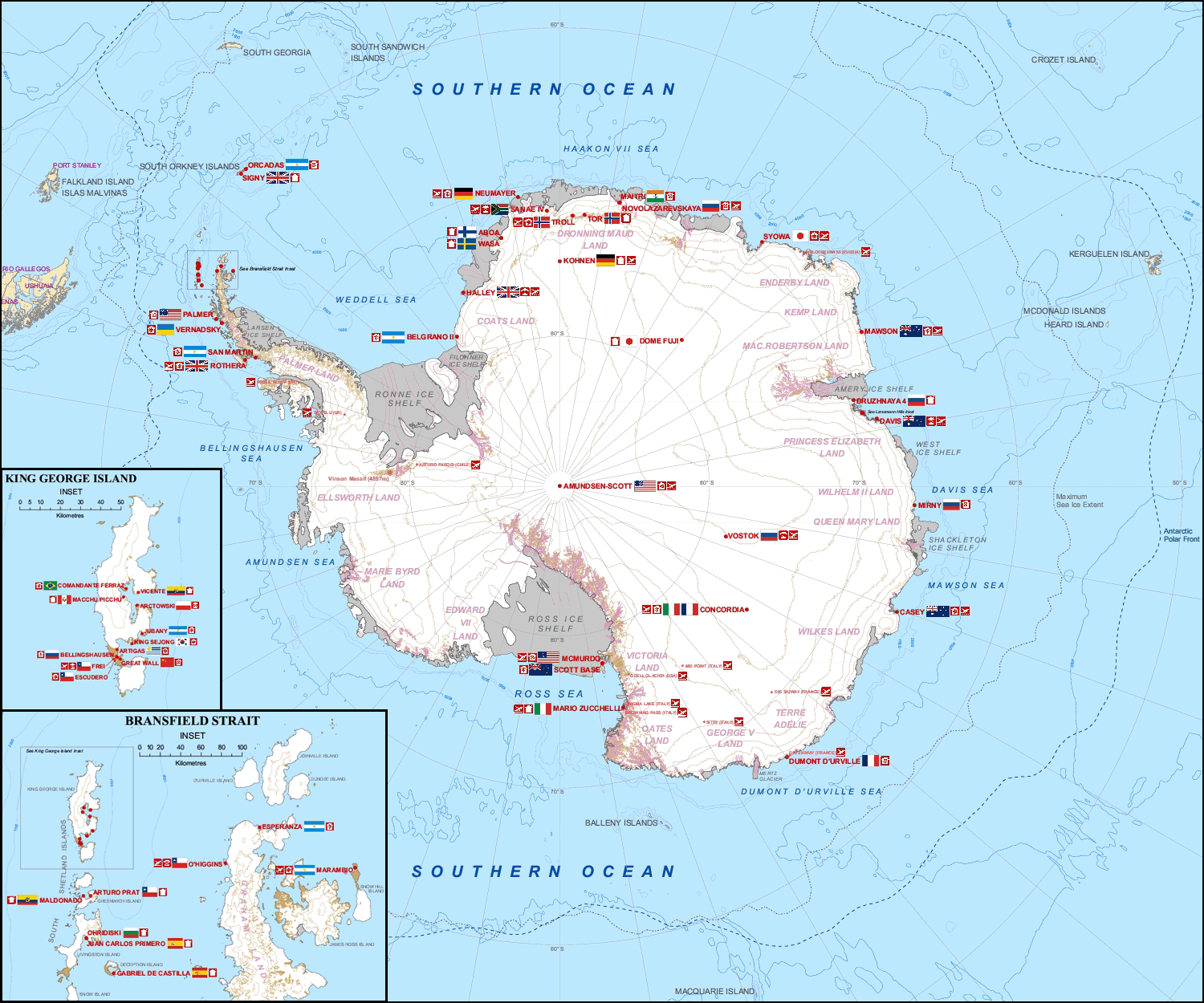
Multiple governments have set up permanent research stations in Antarctica and these bases are widely distributed. Unlike the drifting ice stations set up in the Arctic, the research stations of the Antarctic are constructed either on rock or on ice that is (for practical purposes) fixed in place. Many of the stations are demographics of Antarctica, staffed throughout the year. A total of 42 countries (as of October 2006), all signatories to the Antarctic Treaty System, Antarctic Treaty, operate seasonal (summer) and year-round research stations on the continent. The population of people performing and supporting scientific research on the continent and nearby islands varies from approximately 4,000 during the summer season to 1,000 during winter (June). In addition to these permanent stations, approximately Antarctic field camps, 30 field camps are established each summer to support specific projects. History First bases During the Heroic Age of Antarctic Exploration in t ... [...More Info...] [...Related Items...] OR: [Wikipedia] [Google] [Baidu] |
Antarctica
Antarctica () is Earth's southernmost and least-populated continent. Situated almost entirely south of the Antarctic Circle and surrounded by the Southern Ocean, it contains the geographic South Pole. Antarctica is the fifth-largest continent, being about 40% larger than Europe, and has an area of . Most of Antarctica is covered by the Antarctic ice sheet, with an average thickness of . Antarctica is, on average, the coldest, driest, and windiest of the continents, and it has the highest average elevation. It is mainly a polar desert, with annual precipitation of over along the coast and far less inland. About 70% of the world's freshwater reserves are frozen in Antarctica, which, if melted, would raise global sea levels by almost . Antarctica holds the record for the lowest measured temperature on Earth, . The coastal regions can reach temperatures over in summer. Native species of animals include mites, nematodes, penguins, seals and tardigrades. Where vegetation o ... [...More Info...] [...Related Items...] OR: [Wikipedia] [Google] [Baidu] |
Ardley Island
Ardley Island is an island long, lying in Maxwell Bay close off the south-west end of King George Island, in the South Shetland Islands of Antarctica. It was charted as a peninsula in 1935 by Discovery Investigations personnel of the '' Discovery II'' and named for Lieutenant R.A.B. Ardley, Royal Naval Reserve, an officer on the ship in 1929–31 and 1931–33. Aerial photography has since shown that the feature is an island with Braillard Point being the headland forming the northeast end of Ardley Island. It has been designated an Antarctic Specially Protected Area (ASPA 150) because of the importance of its seabird colonies. Birds The island has been identified as an Important Bird Area by BirdLife International because it supports a breeding colony of about 4,600 pairs of gentoo penguins, as well as smaller numbers of Adélie and chinstrap penguins, southern giant petrels, Wilson's and black-bellied storm petrels, Cape petrels, brown and south polar skuas, and An ... [...More Info...] [...Related Items...] OR: [Wikipedia] [Google] [Baidu] |
King George Island (Antarctica)
King George Island (Argentinian Spanish: Isla 25 de Mayo, Chilean Spanish: Isla Rey Jorge, Russian: Ватерло́о Vaterloo) is the largest of the South Shetland Islands, lying off the coast of Antarctica in the Southern Ocean. The island was named after King George III. Geography King George island has three major bays, Maxwell Bay, Admiralty Bay, and King George Bay. Admiralty Bay contains three fjords, and is protected as an Antarctic Specially Managed Area under the Protocol on Environmental Protection to the Antarctic Treaty. History The island was first claimed for Britain on 16 October 1819, formally annexed by Britain as part of the Falkland Islands Dependencies in 1908, and now as part of the separate British Antarctic Territory. The Island was claimed by Chile in 1940, as part of the Chilean Antarctic Territory. It was also claimed by Argentina in 1943, now as part of Argentine Antarctica, called by the Argentines ''Isla Veinticinco de Mayo'' (25 May) in ho ... [...More Info...] [...Related Items...] OR: [Wikipedia] [Google] [Baidu] |
South Shetland Islands
The South Shetland Islands are a group of Antarctic islands with a total area of . They lie about north of the Antarctic Peninsula, and between southwest of the nearest point of the South Orkney Islands. By the Antarctic Treaty of 1959, the islands' sovereignty is neither recognized nor disputed by the signatories and they are free for use by any signatory for non-military purposes. The islands have been claimed by the United Kingdom since 1908 and as part of the British Antarctic Territory since 1962. They are also claimed by the governments of Chile (since 1940, as part of the Antártica Chilena province) and Argentina (since 1943, as part of Argentine Antarctica, Tierra del Fuego Province). Several countries maintain research stations on the islands. Most of them are situated on King George Island, benefitting from the airfield of the Chilean base Eduardo Frei. There are sixteen research stations in different parts of the islands, with Chilean stations being ... [...More Info...] [...Related Items...] OR: [Wikipedia] [Google] [Baidu] |
Instituto Antártico Chileno
The Chilean Antarctic Institute (in Spanish Instituto Antártico Chileno) is a public service institution in charge of managing and coordinating scientific activities in the Chilean Antarctic Territory. It is the national Antarctic operator and has an active role in Antarctic affairs. External linksOfficial website {{DEFAULTSORT:Instituto Antartico Chileno Chilean Antarctic Territory Research institutes in Chile Chile Chile, officially the Republic of Chile, is a country in the western part of South America. It is the southernmost country in the world, and the closest to Antarctica, occupying a long and narrow strip of land between the Andes to the east a ... Chile and the Antarctic ... [...More Info...] [...Related Items...] OR: [Wikipedia] [Google] [Baidu] |
Chile
Chile, officially the Republic of Chile, is a country in the western part of South America. It is the southernmost country in the world, and the closest to Antarctica, occupying a long and narrow strip of land between the Andes to the east and the Pacific Ocean to the west. Chile covers an area of , with a population of 17.5 million as of 2017. It shares land borders with Peru to the north, Bolivia to the north-east, Argentina to the east, and the Drake Passage in the far south. Chile also controls the Pacific islands of Juan Fernández, Isla Salas y Gómez, Desventuradas, and Easter Island in Oceania. It also claims about of Antarctica under the Chilean Antarctic Territory. The country's capital and largest city is Santiago, and its national language is Spanish. Spain conquered and colonized the region in the mid-16th century, replacing Inca rule, but failing to conquer the independent Mapuche who inhabited what is now south-central Chile. In 1818, after declaring in ... [...More Info...] [...Related Items...] OR: [Wikipedia] [Google] [Baidu] |
Chilean Antarctic Territory
The Chilean Antarctic Territory or Chilean Antarctica (Spanish: ''Territorio Chileno Antártico'', ''Antártica Chilena'') is the territory in Antarctica claimed by Chile. The Chilean Antarctic Territory ranges from 53° West to 90° West and from the South Pole to the 60° South parallel, partially overlapping the Argentine and British Antarctic claims. It is administered by the Cabo de Hornos municipality in the South American mainland. The territory claimed by Chile covers the South Shetland Islands, Antarctic Peninsula, called ''"O'Higgins Land"'' ''("Tierra de O'Higgins" in Spanish)'' in Chile, and adjacent islands, the Alexander Island, Charcot Island, and part of the Ellsworth Land, among others. It has an area of 1,250,257.6 km2. Its boundaries are defined by Decree 1747, issued on November 6, 1940, and published on June 21, 1955, the Ministry of Foreign Affairs established: Within Chilean territorial organization Antártica is the name of the commune that ad ... [...More Info...] [...Related Items...] OR: [Wikipedia] [Google] [Baidu] |
Meters
The metre (British spelling) or meter (American spelling; see spelling differences) (from the French unit , from the Greek noun , "measure"), symbol m, is the primary unit of length in the International System of Units (SI), though its prefixed forms are also used relatively frequently. The metre was originally defined in 1793 as one ten-millionth of the distance from the equator to the North Pole along a great circle, so the Earth's circumference is approximately km. In 1799, the metre was redefined in terms of a prototype metre bar (the actual bar used was changed in 1889). In 1960, the metre was redefined in terms of a certain number of wavelengths of a certain emission line of krypton-86. The current definition was adopted in 1983 and modified slightly in 2002 to clarify that the metre is a measure of proper length. From 1983 until 2019, the metre was formally defined as the length of the path travelled by light in a vacuum in of a second. After the 2019 redefiniti ... [...More Info...] [...Related Items...] OR: [Wikipedia] [Google] [Baidu] |
Gentoo Penguins
The gentoo penguin ( ) (''Pygoscelis papua'') is a penguin species (or possibly a species complex) in the genus ''Pygoscelis'', most closely related to the Adélie penguin (''P. adeliae'') and the chinstrap penguin (''P. antarcticus''). The earliest scientific description was made in 1781 by Johann Reinhold Forster with a Type locality (biology), type locality in the Falkland Islands. The species calls in a variety of ways, but the most frequently heard is a loud trumpeting, which the bird emits with its head thrown back. Names The application of "gentoo" to the penguin is unclear. ''Gentoo (term), Gentoo'' was an Anglo-Indian term to distinguish Hindus from Muslims. The English term may have originated from the Portuguese ''gentio'' ("pagan, gentile"). Some speculate that the white patch on the bird's head was thought to resemble a turban. It may also be a variation of another name for this bird, "Johnny penguin", with Johnny being in Spanish and sounds vaguely like gentoo. Th ... [...More Info...] [...Related Items...] OR: [Wikipedia] [Google] [Baidu] |
Antarctic Field Camps
Many Antarctic research stations support satellite field camps which are, in general, seasonal camps. The type of field camp can vary – some are permanent structures used during the annual Antarctic summer, whereas others are little more than tents used to support short term activities. Field camps are used for many things, from logistics (Sky Blu) to dedicated scientific research (WAIS Divide Field Camp). List of field camps See also *Research stations in Antarctica *Demographics of Antarctica *List of Antarctic expeditions This list of Antarctic expeditions is a chronological list of expeditions involving Antarctica. Although the existence of a southern continent had been hypothesized as early as the writings of Ptolemy in the 1st century AD, the South Pole was no ... * Transport in Antarctica References External links COMNAP Antarctic Facilities() COMNAP Antarctic Facilities Map() Antarctic Digital Database Map ViewerSCAR {{Polar exploration Field ... [...More Info...] [...Related Items...] OR: [Wikipedia] [Google] [Baidu] |


