|
Jerusalem Metropolitan Area
In Israel, the Jerusalem metropolitan area is the area encompassing the approximately one hundred square miles surrounding the Old City of Jerusalem with a population of 1,253,900. The expansion of Jerusalem under Israeli law followed its official annexation of the city in the aftermath of the 1967 . Greater Jerusalem is divided into three areas: the outer ring, the New City/Center, and The Historical Center/Inner Ring. The rings are mainly used as an administrative tool to incorporate, public transit, housing, and utility services under a common structure. Greater Jerusalem can be said to encompass the entire City of Jerusalem (both its |
Israel
Israel (; he, יִשְׂרָאֵל, ; ar, إِسْرَائِيل, ), officially the State of Israel ( he, מְדִינַת יִשְׂרָאֵל, label=none, translit=Medīnat Yīsrāʾēl; ), is a country in Western Asia. It is situated on the southeastern shore of the Mediterranean Sea and the northern shore of the Red Sea, and shares borders with Lebanon to the north, Syria to the northeast, Jordan to the east, and Egypt to the southwest. Israel also is bordered by the Palestinian territories of the West Bank and the Gaza Strip to the east and west, respectively. Tel Aviv is the economic and technological center of the country, while its seat of government is in its proclaimed capital of Jerusalem, although Israeli sovereignty over East Jerusalem is unrecognized internationally. The land held by present-day Israel witnessed some of the earliest human occupations outside Africa and was among the earliest known sites of agriculture. It was inhabited by the Canaanites ... [...More Info...] [...Related Items...] OR: [Wikipedia] [Google] [Baidu] |
Mevasseret Zion
Mevaseret Zion ( he, מְבַשֶּׂרֶת צִיּוֹן, literal meaning: Herald of Zion – Jerusalem) is a suburb of Jerusalem with the administrative status of a local council. Mevaseret Zion is composed of two distinct older townships, Maoz Zion and Mevaseret Yerushalayim, under the jurisdiction of one local council. The newer neighborhoods of Mevaseret Zion were not part of either settlement. Mevaseret Zion is located on a mountain ridge above sea level, on the outskirts of Jerusalem. It is from the city, straddling both sides of the Jerusalem–Tel Aviv highway. In it had a population of 24,409, spread over 15 neighborhoods. It is the wealthiest municipality per capita in the Jerusalem District. Mevaseret Zion's current mayor is Yoram Shimon. History Castel area Due to its strategic location, settlement in the area of Mevasseret Zion goes back to antiquity. The Romans built a fortress there, known as Castellum. On the ruins of this fortress, the Crusaders built a ca ... [...More Info...] [...Related Items...] OR: [Wikipedia] [Google] [Baidu] |
Positions On Jerusalem
The status of Jerusalem is disputed in both international law and diplomatic practice, with both the Israelis and Palestinians claiming Jerusalem as their capital city.Moshe Hirsch, Deborah Housen-Couriel, Ruth Lapidoth''Whither Jerusalem?: Proposals and Positions Concerning the future of Jerusalem'' Martinus Nijhoff Publishers, 1995. pg. 15. . The dispute has been described as "one of the most intractable issues in the Israeli–Palestinian conflict", with conflicting claims to sovereignty over the city or parts of it, and access to its holy sites. The main dispute revolves around the legal status of East Jerusalem and especially the Old City of Jerusalem, while broader agreement exists regarding future Israeli presence in West Jerusalem in accordance with Israel's internationally recognised borders. The majority of United Nations (UN) member states hold the view that the final status of Jerusalem should be resolved through negotiation, and have therefore favored locating the ... [...More Info...] [...Related Items...] OR: [Wikipedia] [Google] [Baidu] |
Green Line (Israel)
The Green Line, (pre-)1967 border, or 1949 Armistice border, is the demarcation line set out in the 1949 Armistice Agreements between the armies of Israel and those of its neighbors (Egypt, Jordan, Lebanon and Syria) after the 1948 Arab–Israeli War. It served as the ''de facto'' borders of the State of Israel from 1949 until the Six-Day War in 1967. The Green Line was intended as a demarcation line rather than a permanent border. The 1949 Armistice Agreements were clear (at Arab insistence) that they were not creating permanent borders. The Egyptian–Israeli agreement, for example, stated that "the Armistice Demarcation Line is not to be construed in any sense as a political or territorial boundary, and is delineated without prejudice to rights, claims and positions of either Party to the Armistice as regards ultimate settlement of the Palestine question." [...More Info...] [...Related Items...] OR: [Wikipedia] [Google] [Baidu] |
City Line (Jerusalem)
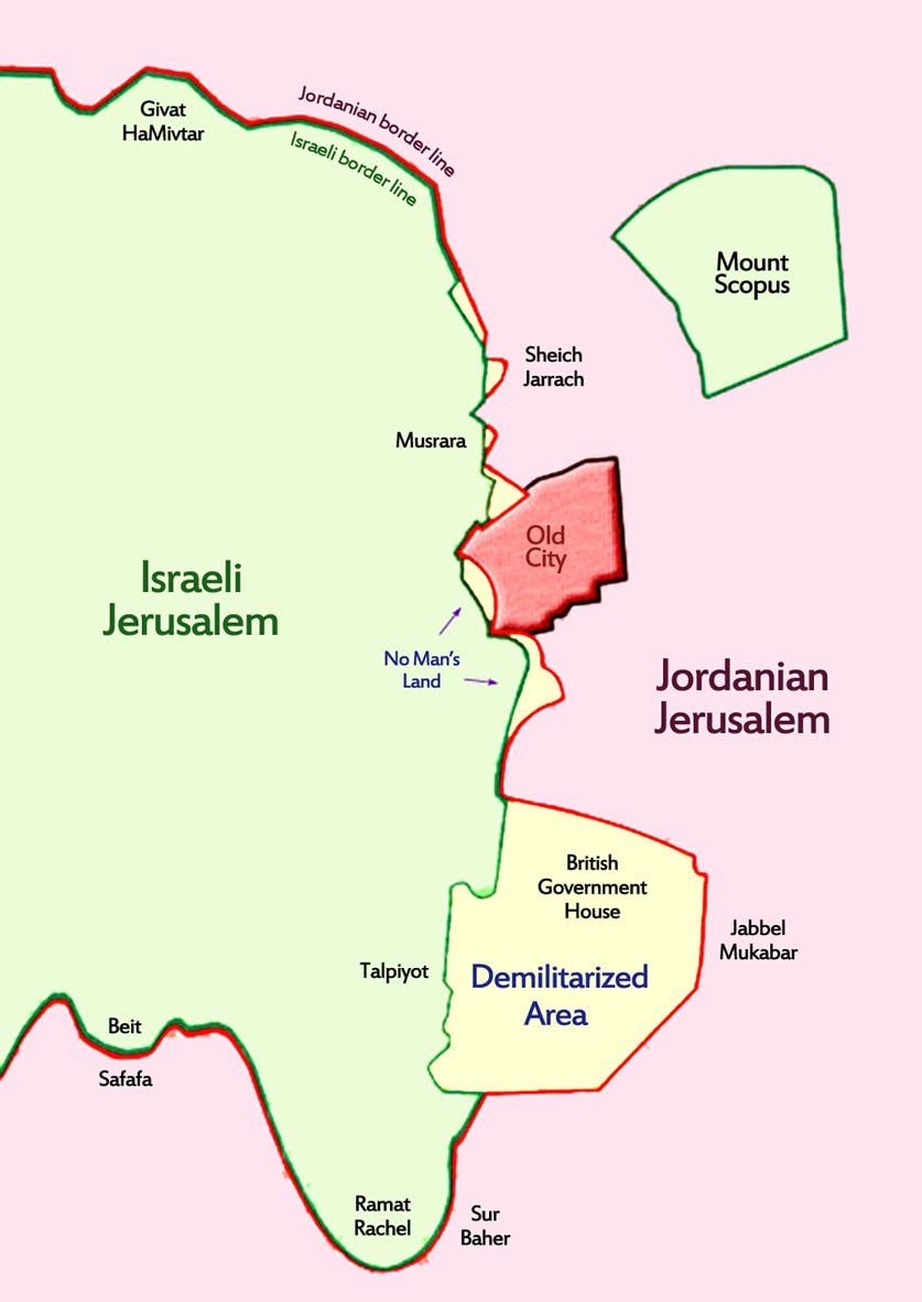
City Line ( he, הקו העירוני, Pronounced: ''HaKav HaIroni'') is the name given to a segment of the Green Line that divided the city of Jerusalem from 1948 to 1967. It was 7 km in length, and constituted a temporary boundary line in accordance with Israel's Armistice Agreement with Jordan, which divided the city between East Jerusalem which was part of the Kingdom of Jordan, and West Jerusalem, the capital of the State of Israel. The Old City bordered the City line on the east side, and thus had been part of the "Jordanian Jerusalem". On both sides of the City line fortifications and obstacles were deployed, and different buildings in the city along the line were used as military posts. History In November 30, 1948, after the end of the 1948 Arab–Israeli War in Jerusalem, Moshe Dayan, commander of the Israeli Etzioni Brigade, and Abdullah el-Tell, the Jordanian commander, met in an abandoned house in Musrara neighborhood. The two officers drew a map at the sc ... [...More Info...] [...Related Items...] OR: [Wikipedia] [Google] [Baidu] |
Jerusalem District
The Jerusalem District ( he, מחוז ירושלים; ar, منطقة القدس) is one of the six administrative districts of Israel. The district capital is Jerusalem. The Jerusalem District has a land area of 652 km2. The population of 1,159,900 is 66.3% Jewish and 32.1% Arab. A fifth (21%) of the Arabs in Israel live in the Jerusalem Municipality, which includes both East and West Jerusalem. Israel's annexation of East Jerusalem has not been recognized by the international community. The majority of Arabs in the Jerusalem District are Palestinians, eligible to apply for citizenship under Israeli law, but either declining to apply or unsuccessful. The minority are Arab citizens of Israel living in Abu Ghosh, Beit Safafa and East Jerusalem, where Arab professionals have settled since the late 1970s, mainly for the provision of legal and other services to the local population. The non-Jewish population is 95.2% Muslim, 3.5% Christian with the others unclassified by relig ... [...More Info...] [...Related Items...] OR: [Wikipedia] [Google] [Baidu] |
Al-Eizariya
Bethany ( grc-gre, Βηθανία,Murphy-O'Connor, 2008, p152/ref> Syriac: ܒܝܬ ܥܢܝܐ ''Bēṯ ʿAnyā'') or what is locally known as Al-Eizariya or al-Azariya ( ar, العيزرية, " laceof Lazarus"), is a Palestinian town in the West Bank. The name al-Eizariya refers to the New Testament figure Lazarus of Bethany, who according to the Gospel of John, was raised from the dead by Jesus. The traditional site of the miracle, the Tomb of Lazarus, in the city is a place of pilgrimage. The town is located on the southeastern slope of the Mount of Olives, less than from Jerusalem. According to the Palestinian Central Bureau of Statistics, it is the second largest Palestinian city in the Jerusalem Governorate (not including East Jerusalem, which is under Israeli control), with a population of 17,606 inhabitants. Being mostly in Area C, it is controlled by the Israeli military rather than the Palestinian Authority. Name Al-Eizariya The name Al-Eizariya ( ar, العيزري ... [...More Info...] [...Related Items...] OR: [Wikipedia] [Google] [Baidu] |
Abu Dis
Abu Dis or Abu Deis ( ar, أبو ديس) is a Palestinian village in the West Bank, in the Jerusalem Governorate of the State of Palestine, bordering Jerusalem. Since the 1995 Oslo II Accord, Abu Dis land has been mostly part of "Area B", under Israeli military control and Palestinian civic control. According to the Palestinian Central Bureau of Statistics (PCBS) census, Abu Dis had a population of 12,604 in 2016. History Abu Dis is situated on an ancient site, surrounded by deep valleys. Ruins have been found of ancient buildings, cisterns, grape presses and caves, one with a columbarium. Ceramics from Late Roman and Byzantine period has also been found. The French explorer Victor Guérin thought Abu Dis was identical with ancient Bahurim, but this identification is not accepted today. Ottoman era Abu Dis was one of the most populous villages in the Sanjak of Jerusalem during the 16th century, with a population of several hundred. Wheat and barley formed the bulk of cash ... [...More Info...] [...Related Items...] OR: [Wikipedia] [Google] [Baidu] |
Bethlehem
Bethlehem (; ar, بيت لحم ; he, בֵּית לֶחֶם '' '') is a city in the central West Bank, Palestine, about south of Jerusalem. Its population is approximately 25,000,Amara, 1999p. 18.Brynen, 2000p. 202. and it is the capital of the Bethlehem Governorate of the State of Palestine. The economy is primarily tourist-driven, peaking during the Christmas season, when Christians make pilgrimage to the Church of the Nativity. The important holy site of Rachel's Tomb is at the northern entrance of Bethlehem, though not freely accessible to the city's own inhabitants and in general Palestinians living in the Israeli-occupied West Bank due to the Israeli West Bank barrier. The earliest known mention of Bethlehem was in the Amarna correspondence of 1350–1330 BCE when the town was inhabited by the Canaanites. The Hebrew Bible, which says that the city of Bethlehem was built up as a fortified city by Rehoboam, identifies it as the city David was from and where he was ... [...More Info...] [...Related Items...] OR: [Wikipedia] [Google] [Baidu] |
El Bireh
Al-Bireh, El Bire, Biré, El Bireh (Arabic: البيرة) or Birra (time of Crusades) is a town in the Rashaya District, south-eastern portion of the Bekaa Governorate of the Republic of Lebanon. Al-Bireh is part of the Rashaya municipal district. It lies west of the road between Majdel Anjar and Rashaya. Its population is estimated to be 9000. It is a small Muslim town with two mosques and two schools. Geography The oldest part of the town lies on top of Jabal Arbi Mountains while the newer parts lie in the Wadi al-Taym valley and is referred to as Izza. Neighboring towns include Rafid, Kamed, Khirbet-Rouha, and Mdouckha. The town is located about 80 km from Beirut and 40 km from Damascus, Syria. From Al-Bireh, Jabal -Al-Sheikh (Mount Hermon) can be seen with its majestic snow-capped peak. Economy More than 60% of the town’s population have emigrated to Brazil, Argentina, United States, Canada, France, Spain, Italy and Portugal. Residents of the town have lef ... [...More Info...] [...Related Items...] OR: [Wikipedia] [Google] [Baidu] |
Ramallah
Ramallah ( , ; ar, رام الله, , God's Height) is a Palestinian city in the central West Bank that serves as the ''de facto'' administrative capital of the State of Palestine. It is situated on the Judaean Mountains, north of Jerusalem, at an average elevation of above sea level, adjacent to al-Bireh. Ramallah has buildings containing masonry from the period of Herod the Great, but no complete building predates the Crusades of the 11th century. The modern city was founded during the 16th century by the Hadadeens, an Arab Christian clan descended from Ghassanids. In 1517, the city was incorporated into the Ottoman Empire, and in 1920, it became part of British Mandatory Palestine after it was captured by the United Kingdom during World War I. The 1948 Arab–Israeli War saw the entire West Bank, including Ramallah, occupied and annexed by Transjordan. Ramallah was later captured by Israel in the 1967 Six-Day War. Since the 1995 Oslo Accords, Ramallah has been go ... [...More Info...] [...Related Items...] OR: [Wikipedia] [Google] [Baidu] |
Maale Adumim
Ma'ale Adumim ( he, מַעֲלֵה אֲדֻמִּים; ar, معالي أدوميم) is an urban Israeli settlement organized as a city council (Israel), city council in the West Bank, seven kilometers () east of Jerusalem. Ma'ale Adumim achieved city council (Israel), city status in 1991. In 2015 its population was . It is located along Highway 1 (Israel), Highway 1, which connects it to Jerusalem and the Tel Aviv Metropolitan Area. The international community considers Israeli settlements in the West Bank International law and Israeli settlements, illegal under international law, but the Israeli government disputes this. Etymology The town name "Ma'ale Adumim" is taken from two mentions made of an area marking the boundaries between two Israelite tribes in the Book of Joshua. At , in a passage on the inheritance of the Tribe of Judah, it is stated that from the Stone of Bohan, son of Reuben, Stone of Bohan the border went up to Debir from the Achor, Valley of Achor, turning n ... [...More Info...] [...Related Items...] OR: [Wikipedia] [Google] [Baidu] |


