|
Islands Of Fleet
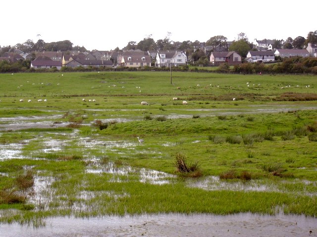
The Islands of Fleet are a group of small islands in Galloway, Scotland. They are in Fleet Bay, which is part of Wigtown Bay, and is in turn part of the Solway Firth in the Irish Sea. There are three main islands. * Murray Isles, owned by the National Trust for Scotland, with the small rock "Horse Mark" off it. * Ardwall Isle (Ard Bhaile - high town), which has a cairn and the remains of a chapel on it, and has the "Old Man of Fleet" off it. The largest of the three, it is approximately in extent.Rick Livingstone’s Tables of the Islands of Scotland (pdf) Argyll Yacht Charters. Retrieved 12 Dec 2011. * Barlocco Island, with the "Three Brethren" off it. Ardwall Isle and Barlocco Isle are two of 43 tidal islands that can be walked to from the mainland of |
Galloway
Galloway ( ; sco, Gallowa; la, Gallovidia) is a region in southwestern Scotland comprising the historic counties of Wigtownshire and Kirkcudbrightshire. It is administered as part of the council area of Dumfries and Galloway. A native or inhabitant of Galloway is called a Gallovidian. The place name Galloway is derived from the Gaelic ' ("amongst the '"). The , literally meaning "Stranger-'"; the specific identity of whom the term was applied to is unknown, but the predominant view is that it referred to an ethnic and/or cultural identity such as the Strathclyde Britons or another related but distinct population. A popular theory is that it refers to a population of mixed Scandinavian and Gaelic ethnicity that may have inhabited Galloway in the Middle Ages. Galloway is bounded by sea to the west and south, the Galloway Hills to the north, and the River Nith to the east; the border between Kirkcudbrightshire and Wigtownshire is marked by the River Cree. The definition has ... [...More Info...] [...Related Items...] OR: [Wikipedia] [Google] [Baidu] |
Scotland
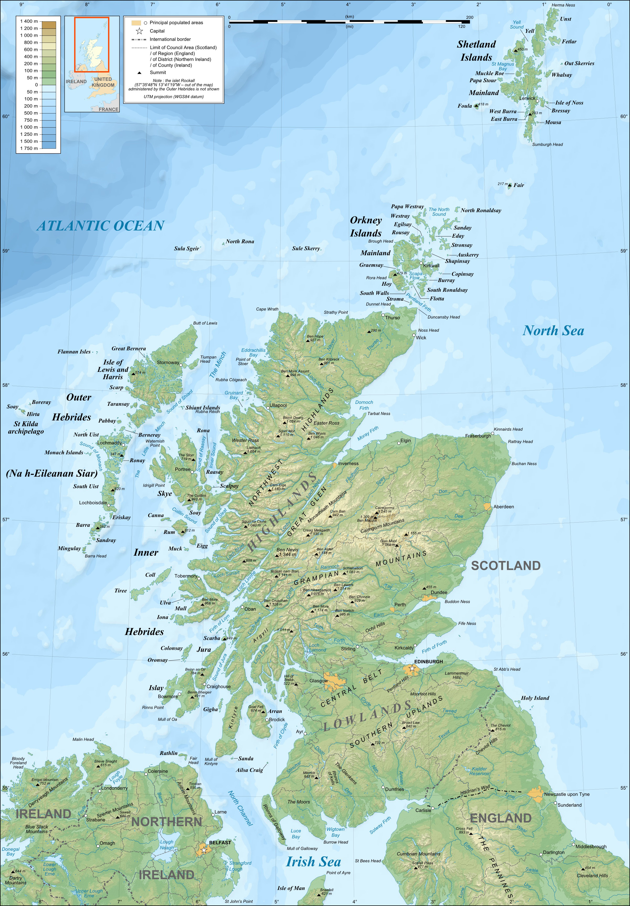
Scotland (, ) is a country that is part of the United Kingdom. Covering the northern third of the island of Great Britain, mainland Scotland has a border with England to the southeast and is otherwise surrounded by the Atlantic Ocean to the north and west, the North Sea to the northeast and east, and the Irish Sea to the south. It also contains more than 790 islands, principally in the archipelagos of the Hebrides and the Northern Isles. Most of the population, including the capital Edinburgh, is concentrated in the Central Belt—the plain between the Scottish Highlands and the Southern Uplands—in the Scottish Lowlands. Scotland is divided into 32 administrative subdivisions or local authorities, known as council areas. Glasgow City is the largest council area in terms of population, with Highland being the largest in terms of area. Limited self-governing power, covering matters such as education, social services and roads and transportation, is devolved from the Scott ... [...More Info...] [...Related Items...] OR: [Wikipedia] [Google] [Baidu] |
Wigtown Bay
Wigtown Bay is a large inlet of the Irish Sea on the coast of Galloway in southwest Scotland. Its coastline falls entirely within the modern administrative area of Dumfries and Galloway and shared between the historical counties of Wigtownshire and Kirkcudbrightshire. The bay is broadly triangular in form, widening to the southeast and with the estuary of the River Cree entering from the northwest at its head. The inner parts of the bay are characterized by large expanses of salt marsh and mudflats. The River Bladnoch flows into the estuarial section of the Cree near Wigtown. The Water of Fleet is a third significant river which enters Wigtown Bay via Fleet Bay on its eastern shore. At the mouth of Fleet Bay are the Islands of Fleet include Ardwall Island, Barlocco Isle and Murray’s Isles. The western shore of the bay is formed by The Machars peninsula. This coast is itself indented by Rigg (or Cruggleton) Bay and by Garlieston Bay on which the village of Garlieston sits. The sm ... [...More Info...] [...Related Items...] OR: [Wikipedia] [Google] [Baidu] |
Solway Firth
The Solway Firth ( gd, Tràchd Romhra) is a firth that forms part of the border between England and Scotland, between Cumbria (including the Solway Plain) and Dumfries and Galloway. It stretches from St Bees Head, just south of Whitehaven in Cumbria, to the Mull of Galloway, on the western end of Dumfries and Galloway. The Isle of Man is also very near to the firth. The firth comprises part of the Irish Sea. The firth’s coastline is characterised by lowland hills and small mountains. It is a mainly rural area, with mostly small villages and settlements (such as Powfoot). Fishing, hill farming, and some arable farming play a large part in the local economy, although tourism is increasing. The northern part of the English coast of the Solway Firth was designated as an Area of Outstanding Natural Beauty, known as the Solway Coast, in 1964. Construction of the Robin Rigg Wind Farm in the firth began in 2007. Within the firth, there are some salt flats and mud flats that can b ... [...More Info...] [...Related Items...] OR: [Wikipedia] [Google] [Baidu] |
Irish Sea
The Irish Sea or , gv, Y Keayn Yernagh, sco, Erse Sie, gd, Muir Èireann , Ulster-Scots: ''Airish Sea'', cy, Môr Iwerddon . is an extensive body of water that separates the islands of Ireland and Great Britain. It is linked to the Celtic Sea in the south by St George's Channel and to the Inner Seas off the West Coast of Scotland in the north by the North Channel. Anglesey, North Wales, is the largest island in the Irish Sea, followed by the Isle of Man. The term ''Manx Sea'' may occasionally be encountered ( cy, Môr Manaw, ga, Muir Meann gv, Mooir Vannin, gd, Muir Mhanainn). On its shoreline are Scotland to the north, England to the east, Wales to the southeast, Northern Ireland and the Republic of Ireland to the west. The Irish Sea is of significant economic importance to regional trade, shipping and transport, as well as fishing and power generation in the form of wind power and nuclear power plants. Annual traffic between Great Britain and Ireland amounts t ... [...More Info...] [...Related Items...] OR: [Wikipedia] [Google] [Baidu] |
National Trust For Scotland
The National Trust for Scotland for Places of Historic Interest or Natural Beauty, commonly known as the National Trust for Scotland ( gd, Urras Nàiseanta na h-Alba), is a Scottish conservation organisation. It is the largest membership organisation in Scotland and describes itself as "the conservation charity that protects and promotes Scotland's natural and cultural heritage for present and future generations to enjoy". The Trust owns and manages around 130 properties and of land, including castles, ancient small dwellings, historic sites, gardens, coastline, mountains and countryside. It is similar in function to the National Trust, which covers England, Wales, and Northern Ireland, and to other national trusts worldwide. History The Trust was established in 1931 following discussions held in the smoking room of Pollok House (now a Trust property). The Trust was incorporated on 1 May 1931, with John Stewart-Murray, 8th Duke of Atholl being elected as its first president, ... [...More Info...] [...Related Items...] OR: [Wikipedia] [Google] [Baidu] |
Great Britain
Great Britain is an island in the North Atlantic Ocean off the northwest coast of continental Europe. With an area of , it is the largest of the British Isles, the largest European island and the ninth-largest island in the world. It is dominated by a maritime climate with narrow temperature differences between seasons. The 60% smaller island of Ireland is to the west—these islands, along with over 1,000 smaller surrounding islands and named substantial rocks, form the British Isles archipelago. Connected to mainland Europe until 9,000 years ago by a landbridge now known as Doggerland, Great Britain has been inhabited by modern humans for around 30,000 years. In 2011, it had a population of about , making it the world's third-most-populous island after Java in Indonesia and Honshu in Japan. The term "Great Britain" is often used to refer to England, Scotland and Wales, including their component adjoining islands. Great Britain and Northern Ireland now constitute the ... [...More Info...] [...Related Items...] OR: [Wikipedia] [Google] [Baidu] |
List Of Islands Of Scotland
This is a list of islands of Scotland, the mainland of which is part of the island of Great Britain. Also included are various other related tables and lists. The definition of an offshore island used in this list is "land that is surrounded by seawater on a daily basis, but not necessarily at all stages of the tide, excluding human devices such as bridges and causeways". Scotland has over 790 offshore islands, most of which are to be found in four main groups: Shetland, Orkney, and the Hebrides, sub-divided into the Inner Hebrides and Outer Hebrides. There are also clusters of islands in the Firth of Clyde, Firth of Forth, and Solway Firth, and numerous small islands within the many bodies of fresh water in Scotland including Loch Lomond and Loch Maree. The largest island is Lewis and Harris which extends to 2,179 square kilometres, and there are a further 200 islands which are greater than 40 hectares in area. Of the remainder, several such as Staffa and the Flannan Isles ... [...More Info...] [...Related Items...] OR: [Wikipedia] [Google] [Baidu] |
List Of Outlying Islands Of Scotland
The outlying islands of Scotland are not part of the larger archipelagos and island groups of Scotland—the Hebrides, the Northern Isles or the Islands of the Forth and Clyde estuaries. None of these islands are currently inhabited and few of them ever were, although Hirta was occupied from the Neolithic age until 1930 and Stroma was permanently occupied until the 1970s and thereafter by lighthouse keepers and their families until 1996. Several other outlying islands have lighthouses, none of which is still staffed. In this list, an island is defined as "land that is surrounded by seawater on a daily basis, but not necessarily at all stages of the tide, excluding human devices such as bridges and causeways". A complication relating to membership of this list is that there are various descriptions of the scope of the Hebrides, the large group of islands that lie off Scotland's west coast. The '' Collins Encyclopedia of Scotland'' describes the Inner Hebrides as lying "east ... [...More Info...] [...Related Items...] OR: [Wikipedia] [Google] [Baidu] |
Islands Of The Solway
An island or isle is a piece of subcontinental land completely surrounded by water. Very small islands such as emergent land features on atolls can be called islets, skerries, cays or keys. An island in a river or a lake island may be called an eyot or ait, and a small island off the coast may be called a holm. Sedimentary islands in the Ganges Delta are called chars. A grouping of geographically or geologically related islands, such as the Philippines, is referred to as an archipelago. There are two main types of islands in the sea: continental islands and oceanic islands. There are also artificial islands (man-made islands). There are about 900,000 official islands in the world. This number consists of all the officially-reported islands of each country. The total number of islands in the world is unknown. There may be hundreds of thousands of tiny islands that are unknown and uncounted. The number of sea islands in the world is estimated to be more than 200,000. The to ... [...More Info...] [...Related Items...] OR: [Wikipedia] [Google] [Baidu] |


