|
Isiolo
Isiolo is a town in Isiolo County, of which it is the capital. It is located in the upper eastern region of Kenya and geographically considered the centre of the country Kenya. It lies 285 kilometres north of the capital Nairobi. The town grew around the local military camps, much of the population being descendants of former Somali soldiers who had fought in World War I as well as other Cushitic-speaking pastoral communities and the Ameru community. The town has an estimated population of 120,000people, most of them living around the outskirts of the town. Like most African cities, there has been a steady increase in the urban population in recent years, especially moving from as far as Moyale, Marsabit and Mandera. Isiolo town is also becoming a centre of interest because of its newly acquired status as a resort city cashing in on the popular Samburu and Shaba Game reserves, which have become preferred destinations after the famed Maasai Mara. Isiolo lies along the long A2 Roa ... [...More Info...] [...Related Items...] OR: [Wikipedia] [Google] [Baidu] |
Lamu Port And Lamu-Southern Sudan-Ethiopia Transport Corridor
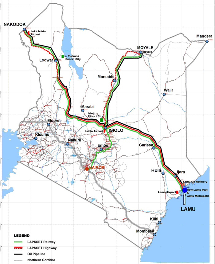
Lamu Port-South Sudan-Ethiopia-Transport (LAPSSET) Corridor project, also known as Lamu corridor is a transport and infrastructure project in Kenya that, when complete, will be the country's second transport corridor. Kenya's other transport corridor is the Mombasa - Uganda transport corridor that passes through Nairobi and much of the Northern Rift. Some basic LAPSSET infrastructure has been built (a police station and harbor office in Lamu and lengthening of the Lamu airport runway). The construction of LAPSSET's main components (ports, pipelines, roads, railways) is currently ongoing with construction of the first berth at Lamu Port completed in October, 2019 (situation as per October 2019).. Although the project is not formally stalled, its short to medium term success looks increasingly unlikely. Insecurity and political instability in Kenya are mostly to blame for this, as are more commercially viable alternative pipeline options through Tanzania or Ethiopia. The low oil ... [...More Info...] [...Related Items...] OR: [Wikipedia] [Google] [Baidu] |
Isiolo County
Isiolo County is a county in the former Eastern Province of Kenya. Its population is 268,002 (2019 census) and its capital and largest city is Isiolo. Isiolo County is to be the first county to be developed as part of the Kenya Vision 2030 program. Other upcoming urban centres are: Garbatulla, Modogashe, Kinna, Merti and Oldonyiro. The local topography is arid or semi-arid low plains. Ewaso Nyiro River flows through the county and partly bounds it. It borders Marsabit County to the north, Wajir County to the east, Garissa and Tana River counties to the south east, Meru County to the south, Laikipia County to the south west and Samburu County to the west. Three different National Game Reserves are located in Isiolo County: Bisanadi National Reserve, Buffalo Springs National Reserve and Shaba National Reserve. Demographics Isiolo county has a total population of 268,002 persons as 2019 census and of this 139,510 are males; 128,483 are females; 9 intersex persons. There i ... [...More Info...] [...Related Items...] OR: [Wikipedia] [Google] [Baidu] |
Vicariate Apostolic Of Isiolo
The Apostolic Vicariate of Isiolo (''Vicariatus Apostolicus Isiolansus'') is a Latin Church missionary jurisdiction or vicariate apostolic in Eastern Province, Kenya. It is exempt to the Holy See, specifically its Roman Congregation for the Evangelization of Peoples, and not part of any ecclesiastical province. It has its episcopal see in Isiolo, where the St. Eusebius Cathedral is located. History It was created on 15 December 1995 as Apostolic Vicariate of Isiolo/ Isiolan(us) (Latin adjective), on territory split off from the Diocese of Meru. Statistics As per 2014, the vicariate pastorally serves 49,800 Catholics (34.8% of 143,294 total) on an area of 25,605 km², in 13 parishes and a mission with 22 priests (16 diocesan, 6 religious), 55 lay religious (9 brothers, 46 sisters) and 12 seminarians. Episcopal ordinaries ;''Apostolic Vicars of Isiolo'' * Luigi Locati (born Italy) (15 Dec 1995 – death 14 July 2005 fatally shot during an attempted robbery), Titul ... [...More Info...] [...Related Items...] OR: [Wikipedia] [Google] [Baidu] |
Luigi Locati
Luigi Locati (July 23, 1928 – July 14, 2005) was an Italian Catholic missionary and bishop. He was shot to death at the pastoral center of Isiolo, Kenya. Two priests, Cyril Mukuchia(Cyril was later found innocent and not guilty and was cleared off all the accusations and charges) and Peter Malley Guyo Wako, were arrested in connection to his murder. Biography Born in the village Vinzaglio in northern Italy, he was ordained as priest on June 29, 1952. In the 1960s he came to Kenya as a missionary and worked as a parish priest in Isiolo. On December 15, 1995, he was appointed as vicar apostolic of the newly created Vicariate Apostolic of Isiolo, Kenya, and titular bishop of . In Isiolo he knew Annalena Tonelli Annalena Tonelli (2 April 1943 – 5 October 2003) was an Italian Catholic lay missionary and social activist. She worked for 33 years in East Africa, where she focused on tuberculosis and HIV/AIDS prevention and treatment, campaigns for era ..., an Italian woman w ... [...More Info...] [...Related Items...] OR: [Wikipedia] [Google] [Baidu] |
Buffalo Springs National Reserve
Buffalo Springs National Reserve is a protected area in the Isiolo County in northern Kenya. Organization The reserve was established in 1948 as part of the Samburu - Isiolo Game Reserve, and the present boundaries were established in 1985. The reserve is managed by the Isiolo County Council. Most operators of Kenyan safaris offer a visit to the reserve, which has several Safari Lodges and safari camps. Location The Buffalo Springs National Reserve is south of the Samburu National Reserve, which lies on the other side of the Ewaso Ngiro river. It is named after an oasis of clear water at its western end. The reserve has an area of , and is at an altitude of between and above sea level. It is a gently rolling lowland plain of old lava flows and volcanic soils of olivine basalt. The main feature is the Champagne Ride in the southeast, an ancient lava-terrace. The climate is hot, dry and semi-arid. Flora There is a narrow band of riverine forest along the Ewaso Ngiro which include ... [...More Info...] [...Related Items...] OR: [Wikipedia] [Google] [Baidu] |
Marsabit
Marsabit is a town in the northern Marsabit County in Kenya. It is situated in the former Eastern Province and is almost surrounded by the Marsabit National Park. The town is located east of the centre of the East African Rift at an elevation of between 1300 and 1400 metres. It serves as the capital of Marsabit County, and lies southeast of the Chalbi Desert in a forested area known for its volcanoes and crater lakes and others. Overview Marsabit is an outpost of urban civilization in the desert of northern Kenya. The town is situated on an isolated extinct volcano, Mount Marsabit, which rises almost a kilometer above the desert. The hills here are heavily forested, in contrast to the desert beyond, with their own "insular" eco-system. The town has a population of about 5,000. The town is mainly inhabited by the Cushitic-speaking Borana Oromo people. There are also very few Nilotic Turkana and Bantu Ameru residents. Additionally, there are also few non-Cushitic-speaking trade ... [...More Info...] [...Related Items...] OR: [Wikipedia] [Google] [Baidu] |
Shaba National Reserve
Shaba National Reserve is a protected area in Isiolo County in northern Kenya to the east of the Samburu and Buffalo Springs national reserves. Together, the three reserves form a large protected area. The Shaba reserve has dramatic scenery including river-side forests, scattered woodlands and dry grasslands dominated by the Shaba Hill volcano. The plentiful wildlife relies on waterholes and marshes scattered throughout the reserve. Shaba is home to the endangered Grevy's zebra and the rare Williams's lark. Shaba was the setting for the book and film ''Born Free'', for the film ''Out of Africa'' and for the reality show '' Survivor: Africa''. The reserve is a popular destination for tourists. There is some risk that excess numbers of visitors and growth of the local population around the reserve may place stress on the environment. Location The Shaba National Reserve was gazetted in 1974. It is administered by the Isiolo County Council. It is just east of Samburu and to th ... [...More Info...] [...Related Items...] OR: [Wikipedia] [Google] [Baidu] |
Counties Of Kenya
The Counties of Kenya ( sw, Kaunti za Kenya) are geographical units envisioned by the 2010 Constitution of Kenya as the new units of devolved government that replaced the previous provincial system. The establishment and executive powers of the counties is provided in Chapter Eleven of the Constitution on devolved government, the Constitution's Fourth Schedule and any other legislation passed by the Senate of Kenya concerning counties. The counties are also single-member constituencies for the election of members of parliament to the Senate of Kenya, and special women members to the National Assembly of Kenya. As of 2022, there are 47 counties whose size and boundaries are based on the 47 legally recognized regions established by the 2010 Constitution. Following the re-organization of Kenya's national administration, counties were integrated into a new national administration with the national government posting county commissioners to counties to serve as a collaborative ... [...More Info...] [...Related Items...] OR: [Wikipedia] [Google] [Baidu] |
A2 Road (Kenya)
The A2 road is a long road in Kenya extending from the Tanzanian border to the Ethiopian border. The northern section of the road, from Isiolo to Moyale, was completely paved in 2016. Towns The following towns, listed from north to south, are located along the highway. * Moyale * Marsabit * Isiolo * Nanyuki * Thika * Nairobi * Athi River * Kajiado * Namanga Namanga is a town divided by the Tanzania-Kenya border. It is in Longido District, Tanzania and Kajiado County, Kenya. It is around 110 kilometers from Arusha, Tanzania. Namanga's economy has been heavily dependent on tourism since 2004 as touri ... References {{Kenya-road-stub Roads in Kenya ... [...More Info...] [...Related Items...] OR: [Wikipedia] [Google] [Baidu] |
Kenya Vision 2030
Kenya Vision 2030 ( Swahili: ''Ruwaza ya Kenya 2030'') is the country's development programme from 2008 to 2030. It was launched on 10 June 2008 by President Mwai Kibaki. Its objective is to help transform Kenya into a "newly industrializing, middle-income country providing a high quality of life to all its citizens by 2030 in a clean and secure environment." Developed through "an all-inclusive and participatory stakeholder consultative process, involving Kenyans from all parts of the country," the Vision is based on three "pillars": Economic, Social, and Political. The Vision's adoption comes after the country's GDP growth went from 0.6% in 2002 to 6.1% in 2006, under Kibaki'Economic Recovery Strategy for Wealth and Employment Creation(ERS). The Kenya Vision 2030 is to be implemented in successive five-year plans, with the first such plan covering the period 2008–2012. Under the Vision, Kenya expected to meet its Millennium Development Goals (MDGs) by the deadline in 2015, al ... [...More Info...] [...Related Items...] OR: [Wikipedia] [Google] [Baidu] |
Lewa Downs
The Lewa Wildlife Conservancy (also known as Lewa Downs) is located in northern Kenya. It was formed in and is a wildlife sanctuary incorporating the Ngare Ndare Forest covering over . The Conservancy is home to a wide variety of wildlife including the rare and endangered black rhinos, Grevy's zebras and sitatungas. It also includes the big five ( lion, leopards, elephants, rhinos and Cape buffaloes). Lewa holds over 12% of Kenya's eastern black rhinoceros population and the largest single population of Grevy's zebras in the world (approximately 350 individuals). The Conservancy is also home to the Northern Rangelands Trust, an innovative partnership with a number of communities to the north who have given land for the preservation of wildlife. Lewa has its own education program that helps develop schools and students. Lewa Wildlife Conservancy is located in Meru County, south of Isiolo town but north of Mount Kenya. History of Lewa The Craig/Douglas family were alloc ... [...More Info...] [...Related Items...] OR: [Wikipedia] [Google] [Baidu] |
Ameru People
The Meru or Amîîrú (including the Ngaa) are a Bantu ethnic group that inhabit the Meru region of Kenya on the fertile lands of north and eastern slopes of Mount Kenya, in the former Eastern Province of Kenya. The word Meru means Shining Light in Kimîîrú language. In Kiswahili, it is Ng'aa, a Bantu word meaning "Dazzling Shine" in both Kimîîrú and Kiswahili languages. Ameru in Kimîîrú language therefore means The Shining Ones or The Children Of The Shining One. The Ameru people comprise nine sections: the Igoji, Imenti, Tigania, Mitine, Igembe, Mwimbi, Muthambi, Chuka and Tharaka. The Tharaka live in the semi-arid part of the greater Meru and they, together with the Mwimbi, Muthambi and Chuka, form the Tharaka-Nithi County. The Ameru are however unrelated to the Wameru of northern Tanzania, other than both being avid farming Bantu communities. Languages The Ngaa people known as Meru speak the Kimîîrú language. Kimîîrú, Kikamba, Kiembu, Kimbeere and Kiku ... [...More Info...] [...Related Items...] OR: [Wikipedia] [Google] [Baidu] |


