|
Innlandet
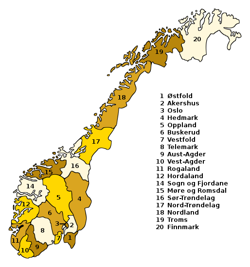
Innlandet is a county in Norway. It was created on 1 January 2020 with the merger of the old counties of Oppland and Hedmark (the municipalities of Jevnaker and Lunner were transferred to the neighboring county of Viken on the same date). The new county has an area of , making it the second largest county in Norway after Troms og Finnmark county. The county name translates to "The Inland" which reflects that the county is the only landlocked county in Norway. The county covers approximately 17% of the total area of the mainland area of Norway. It stretches from the Viken county and the Oslo region in the south to Trøndelag county in the north. In the northwest, the county borders Møre og Romsdal and the Vestland county in the west. To the east the county borders the Swedish counties of Värmland and Dalarna. The northern and western areas of the county are dominated by the mountainous areas Rondane, Dovrefjell and Jotunheimen. The Galdhøpiggen mountain is located with ... [...More Info...] [...Related Items...] OR: [Wikipedia] [Google] [Baidu] |
Lillehammer
Lillehammer () is a municipality in Innlandet county, Norway. It is located in the traditional district of Gudbrandsdal. The administrative centre of the municipality is the town of Lillehammer. Some of the more notable villages in the municipality include Fåberg, Hunderfossen, Jørstadmoen, Vingnes, and Vingrom. The municipality is the 211th largest by area out of the 356 municipalities in Norway. Lillehammer is the 38th most populous municipality in Norway with a population of 28,425. The municipality's population density is and its population has increased by 6.2% over the previous 10-year period. The town of Lillehammer is the largest urban centre in the municipality. It lies in the central part of the municipality and it is surrounded by more rural areas. The town centre is a late nineteenth-century concentration of wooden houses, which enjoys a picturesque location overlooking the northern part of lake Mjøsa and the river Lågen, surrounded by mountains. Lil ... [...More Info...] [...Related Items...] OR: [Wikipedia] [Google] [Baidu] |
Hamar
Hamar is a town in Hamar Municipality in Innlandet county, Norway. Hamar is the administrative centre of Hamar Municipality. It is located in the traditional region of Hedmarken. The town is located on the shores of Mjøsa, Norway's largest lake. Historically, it was the principal city of the former Hedmark county which is now part of the larger Innlandet county. The town of Hamar lies in the southwestern part of the municipality, and the urban area of the town actually extends over the municipal borders into both Ringsaker and Stange municipalities. The town has a population (2021) of 28,535 and a population density of . About and 2,109 residents within the town are actually located in Ringsaker Municipality and another and 305 residents of the town are located within Stange Municipality. General information Name The municipality (originally the town) is named after the old farm ( non, Hamarr). The medieval market was first built on this farm and that market eventually beca ... [...More Info...] [...Related Items...] OR: [Wikipedia] [Google] [Baidu] |
Knut Storberget
Knut Storberget (born 6 October 1964) is a Norwegian lawyer and politician for the Labour Party. He is currently serving as the county governor of Innlandet since 2019. He previously served as Minister of Justice under Jens Stoltenberg from 2005 to 2011. He was also an MP for Hedmark from 2001 to 2017, and deputy MP for the same constituency from 1993 to 2001. Early life and education Storberget was born in the small town of Elverum, Hedmark, on 6 October 1964. The son of forester Lars Storberget (1921–1992) and nurse Marit Drangsholt-Salvesen (1923–1992). After completing high school, he attended the University of Oslo, graduating first in 1985, receiving an associate degree in Political science, he later received a law degree after completing law school at the same university in 1990. Political career From 1992 to 2002 he worked as an attorney-at-law, participating in several high-profile cases, including at the supreme court. He was namely a defense attorney. On the lo ... [...More Info...] [...Related Items...] OR: [Wikipedia] [Google] [Baidu] |
Galdhøpiggen
Galdhøpiggen () is the highest mountain in Norway, Scandinavia, and Northern Europe. The tall mountain is located in Lom Municipality in Innlandet county, Norway. It is in the Jotunheimen mountains within Jotunheimen National Park. The mountain sits about southwest of the village of Fossbergom and about northeast of the village of Øvre Årdal. The mountain is surrounded by several other notable mountains including Keilhaus topp to the east; Store Styggehøe to the southeast; Svellnosbreahesten, Midtre Tverråtinden, and Store Tverråtinden to the south; Storjuvtinden and Skardstinden to the west; Veslpiggen, Storgrovtinden, and Storgrovhøe to the northwest; and Galdhøi and Juvvasshøi to the northeast. Etymology ''Galdhøpiggen'' means "the peak/spike ('' piggen'') of the mountain Galdhø." The first element in the name of the mountain is '' gald'' (m.) which means "steep mountain road". The last element is '' hø'' (f.) which means "(big and) rounded mountain." An ... [...More Info...] [...Related Items...] OR: [Wikipedia] [Google] [Baidu] |
Dovrefjell
Dovrefjell is a mountain range in Central Norway that forms a natural barrier between Eastern Norway and Trøndelag. The mountain range is located in Innlandet, Møre og Romsdal, and Trøndelag counties in Norway. As a result of its central location, its valleys and passes have been heavily trafficked during and probably preceding historical times. Several mountain inns were established in the Middle Ages to house pilgrims traveling through Dovrefjell to Trondheim, and there are even ruins of an old leper colony in the northern area of it. The main south-north highway (European route E6) and the Dovrebanen railway line both run through a mountain pass in the Dovrefjell range. The highway is a year-round highway but on rare occasions it is closed for short periods during heavy winter weather conditions. The mountain range runs through the municipalities of Oppdal in Trøndelag county, Folldal, Dovre, and Lesja in Innlandet county, and Sunndal in Møre og Romsdal c ... [...More Info...] [...Related Items...] OR: [Wikipedia] [Google] [Baidu] |
Counties Of Norway
Norway is divided into 11 administrative regions, called counties (singular no, fylke, plural nb, fylker; nn, fylke from Old Norse: ''fylki'' from the word "folk", sme, fylka, sma, fylhke, smj, fylkka, fkv, fylkki) which until 1918 were known as '' amter''. The counties form the first-level administrative divisions of Norway and are further subdivided into 356 municipalities (''kommune'', pl. ''kommuner'' / ''kommunar''). The island territories of Svalbard and Jan Mayen are outside the county division and ruled directly at the national level. The capital Oslo is both a county and a municipality. In 2017, the Solberg government decided to abolish some of the counties and to merge them with other counties to form larger ones, reducing the number of counties from 19 to 11, which was implemented on 1 January 2020. This sparked popular opposition, with some calling for the reform to be reversed. The Storting voted to partly undo the reform on 14 June 2022, ... [...More Info...] [...Related Items...] OR: [Wikipedia] [Google] [Baidu] |
Atnsjøen
Atnsjøen is a lake in Innlandet county, Norway. The lake lies along the border of the municipalities of Sør-Fron and Stor-Elvdal, just east of Rondane National Park. The Norwegian County Road 27 runs along the eastern shoreline of the entire lake. The village of Sollia lies about to the southeast of the lake. See also *List of lakes in Norway This is a list of lakes and reservoirs in Norway, sorted by Counties of Norway, county. For the geography and history of lakes in that country, see Lakes in Norway, including: *Lakes in Norway#Largest lakes, List of largest lakes in Norway *L ... References Sør-Fron Stor-Elvdal Lakes of Innlandet {{Innlandet-lake-stub ... [...More Info...] [...Related Items...] OR: [Wikipedia] [Google] [Baidu] |
Oppland
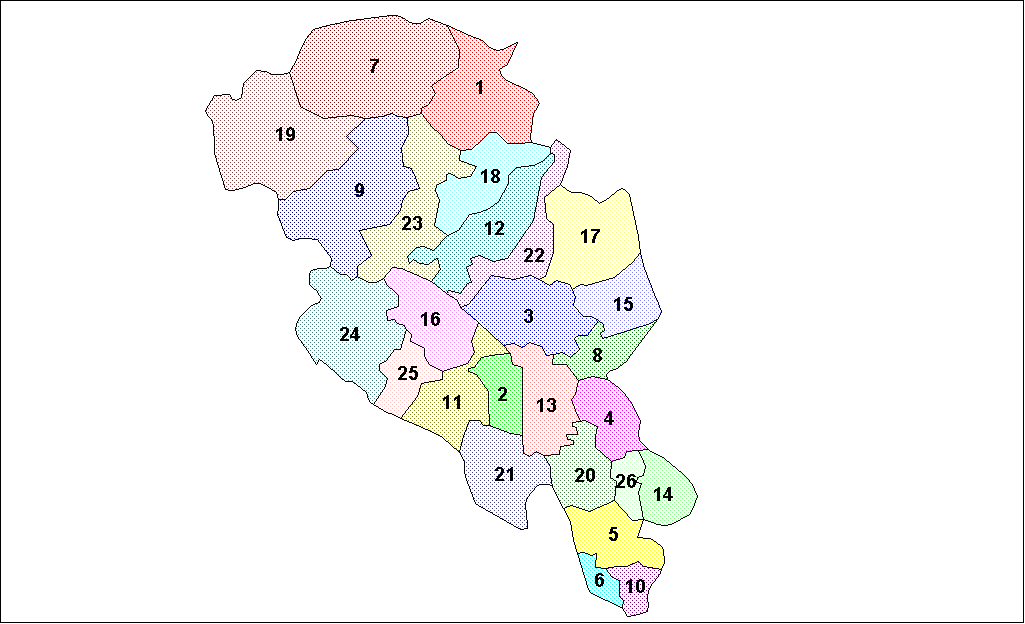
Oppland is a former county in Norway which existed from 1781 until its dissolution on 1 January 2020. The old Oppland county bordered the counties of Trøndelag, Møre og Romsdal, Sogn og Fjordane, Buskerud, Akershus, Oslo and Hedmark. The county administration was located in the town of Lillehammer. Merger On 1 January 2020, the neighboring counties of Oppland and Hedmark were merged to form the new Innlandet county. Both Oppland and Hedmark were the only landlocked counties of Norway, and the new Innlandet county is the only landlocked county in Norway. The two counties had historically been one county that was divided in 1781. Historically, the region was commonly known as " Opplandene". In 1781, the government split the area into two: Hedemarkens amt and Kristians amt (later renamed Hedmark and Oppland. In 2017, the government approved the merger of the two counties. There were several names debated, but the government settled on '' Innlandet''. Geography Oppland ... [...More Info...] [...Related Items...] OR: [Wikipedia] [Google] [Baidu] |
Rondane
Rondane National Park ( no, Rondane nasjonalpark) is the oldest national park in Norway, having been established on 21 December 1962. The park is located in Innlandet county, in the municipalities of Dovre, Folldal, Sel, Nord-Fron, Sør-Fron, Stor-Elvdal, and Ringebu. The park contains ten peaks above , with the highest being Rondeslottet at an altitude of . The park is an important habitat for herds of wild reindeer. The park was enlarged in 2003, and now covers an area of . Rondane lies just to the east of the Gudbrandsdalen valley and two other mountain areas, Dovre and Jotunheimen are nearby. Dovre National Park lies a very short distance to the north of this park. Geography Rondane is a typical high mountain area, with large plateaus and a total of ten peaks above . The highest point is Rondeslottet ("The Rondane Castle") at an altitude of . The lowest point is just below the tree line, which is located at approximately above sea level. The climate is mild but re ... [...More Info...] [...Related Items...] OR: [Wikipedia] [Google] [Baidu] |
Jotunheimen
Jotunheimen (; "the home of the Jötunn") is a mountainous area of roughly in southern Norway and is part of the long range known as the Scandinavian Mountains. The 29 highest mountains in Norway are all located in the Jotunheimen mountains, including the tall mountain Galdhøpiggen (the highest point in Norway). The Jotunheimen mountains straddle the border between Innlandet and Vestland counties (historically part of the old Oppland and Sogn og Fjordane counties). Tourism Jotunheimen is very popular with hikers and climbers, and the Norwegian Mountain Touring Association maintains a number of mountain lodges in the area, as well as marked trails that run between the lodges and others that run up to some of the peaks. The area has more than 50 marked trails, ranging from shorter hikes to multi day trails. The image from Gjende shows a cliff trailing down into the lake. At its base there is a popular guest house called Memurubu. The picture is taken from Gjendesheim, ... [...More Info...] [...Related Items...] OR: [Wikipedia] [Google] [Baidu] |
Mjøsa
Mjøsa is Norway's largest lake, as well as one of the deepest lakes in Norway and in Europe. It is the fourth-deepest lake in Norway. It is located in the southern part of Norway, about north of the city of Oslo. Its main tributary is the river Gudbrandsdalslågen flowing in from the north; the only distributary is the river Vorma in the south. Inflows would theoretically need 5.6 years to fill the lake. With an average depth of about , most of the lake's volume is under sea level. The average outflow of the lake (measured from 1931–1982) is which is about . Mjøsa contains about of water compared to the in the lake Røssvatnet, the second largest lake by volume in Norway. With a surface elevation of about , the depth of Mjøsa means that the deepest part of the basin is located approximately below sea level. This is lower than the deepest point of the sea inlet of Kattegat and the lower than the vast majority of Skagerrak off Norway's south coast. Mjøsa retains a l ... [...More Info...] [...Related Items...] OR: [Wikipedia] [Google] [Baidu] |
Hedmark
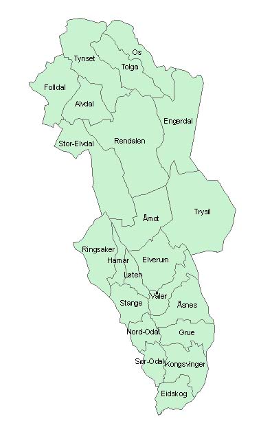
Hedmark () was a county in Norway before 1 January 2020, bordering Trøndelag to the north, Oppland to the west, Akershus to the south, and Sweden to the east. The county administration is in Hamar. Hedmark and Oppland counties were merged into Innlandet county on 1 January 2020, when Norway's former 19 counties became 10 bigger counties / regions Hedmark made up the northeastern part of Østlandet, the southeastern part of the country. It had a long border with Sweden to the east ( Dalarna County and Värmland County). The largest lakes were Femunden and Mjøsa, the largest lake in Norway. Parts of Glomma, Norway's longest river, flowed through Hedmark. Geographically, Hedmark was traditionally divided into: Hedemarken (east of the lake Mjøsa), Østerdalen ("East Valley" north of the town Elverum), and Solør / Glåmdalen (south of Elverum) and Odal in the very south. Hedmark and Oppland were the only Norwegian counties with no coastline. Hedmark also hoste ... [...More Info...] [...Related Items...] OR: [Wikipedia] [Google] [Baidu] |


