|
Inchmurrin
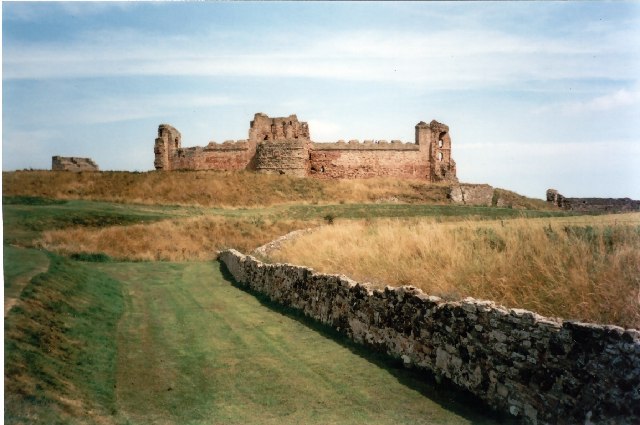
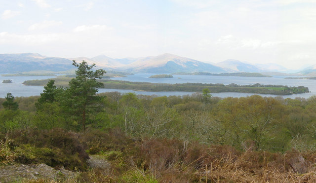
Inchmurrin ( gd, Innis Mhearain) is an island in Loch Lomond in Scotland. It is the largest fresh water island in the British Isles. Geography and geology Inchmurrin is the largest and most southerly of the islands in Loch Lomond. It reaches a height of towards the north and is largely wooded. There is an excellent view of the north end of the loch. Along with Creinch, Torrinch, and Inchcailloch, Inchmurrin forms part of the Highland boundary fault. History Inchmurrin was the site of a 7th-century monastery, with a chapel dedicated to Saint Mirin, after whom it was named. The island was formerly a deer park of the Dukes of Montrose, who had a hunting lodge built in 1793 and maintained a gamekeeper and his family there. 200 deer are recorded in 1800. There are ruins of a castle, probably built for Duncan, 8th Earl of Lennox whose seat was Balloch Castle at the south end of Loch Lomond. The castle was probably a hunting lodge for the deer park established on the island ... [...More Info...] [...Related Items...] OR: [Wikipedia] [Google] [Baidu] |
Loch Lomond
Loch Lomond (; gd, Loch Laomainn - 'Lake of the Elms'Richens, R. J. (1984) ''Elm'', Cambridge University Press.) is a freshwater Scottish loch which crosses the Highland Boundary Fault, often considered the boundary between the lowlands of Central Scotland and the Highlands.Tom Weir. ''The Scottish Lochs''. pp. 33-43. Published by Constable and Company, 1980. Traditionally forming part of the boundary between the counties of Stirlingshire and Dunbartonshire, Loch Lomond is split between the council areas of Stirling, Argyll and Bute and West Dunbartonshire. Its southern shores are about northwest of the centre of Glasgow, Scotland's largest city. The Loch forms part of the Loch Lomond and The Trossachs National Park which was established in 2002. Loch Lomond is long and between wide, with a surface area of . It is the largest lake in Great Britain by surface area; in the United Kingdom, it is surpassed only by Lough Neagh and Lough Erne in Northern Ireland. In the Briti ... [...More Info...] [...Related Items...] OR: [Wikipedia] [Google] [Baidu] |
Isabella Of Lennox
Isabella of Lennox (d.1458) was the ruler of Lennox, from 1437–1458, and last in the line of Mormaers or native Scottish rulers. As the wife of Murdoch Stewart, 2nd Duke of Albany (d.1425), she was also Duchess of Albany (1420–1425), but in 1425 her family would be almost completely destroyed when her husband, father and two sons were executed by King James I of Scotland because of their rebellion. Only one son, James the Fat, would escape their family's punishment, and he would die in exile in Ireland. Isabella succeeded in escaping the fate of her family, and would eventually regain her title and estates, retiring to her castle in Loch Lomond where she raised her grandchildren. She would eventually live to see the assassination of her family's opponent, King James. Though none of her four sons survived her, her grandson Andrew Stewart, 1st Lord Avandale would in time rise to become Lord Chancellor of Scotland. Early life Isabella was the daughter of Donnchadh, Earl of L ... [...More Info...] [...Related Items...] OR: [Wikipedia] [Google] [Baidu] |
Highland Boundary Fault
The Highland Boundary Fault is a major fault zone that traverses Scotland from Arran and Helensburgh on the west coast to Stonehaven in the east. It separates two different geological terranes which give rise to two distinct physiographic terrains: the Highlands and the Lowlands, and in most places it is recognisable as a change in topography. Where rivers cross the fault, they often pass through gorges, and the associated waterfalls can be a barrier to salmon migration. The fault is believed to have formed in conjunction with the Strathmore syncline to the south-east during the Acadian orogeny in a transpressive regime that caused the uplift of the Grampian block and a small sinistral movement on the Highland Boundary Fault. Discovery One of the earliest and most prominent references to the Highland Boundary Fault was by George Barrow in 1912 ʻOn the Geology of Lower Dee-side and the Southern Highland Borderʼ, which highlights the nature of the rocks accompanying the ... [...More Info...] [...Related Items...] OR: [Wikipedia] [Google] [Baidu] |
Balloch Castle (West Dunbartonshire)
Balloch Castle is an early 19th-century country house situated at the southern tip of Loch Lomond, in West Dunbartonshire, Scotland. Balloch was a property of the Lennox family from the 11th century, and the old castle was built in the 13th century. In the 19th century the estate was purchased by John Buchanan of Ardoch, who demolished the ruins of the old castle and erected the present building. The Tudor Gothic architecture is the work of Robert Lugar. In 1915 Balloch was bought by Glasgow City Corporation, and has been leased by West Dunbartonshire Council since 1975. The estate was designated as a country park in 1980, and since 2002 has been part of Loch Lomond and The Trossachs National Park. Although the house has been periodically used for visitor facilities and council offices, it is now included on the Buildings at Risk Register. Balloch Castle is a category A listed building, and the estate is included on the Inventory of Gardens and Designed Landscapes in Scotland. H ... [...More Info...] [...Related Items...] OR: [Wikipedia] [Google] [Baidu] |
Donnchadh, Earl Of Lennox
Donnchadh of Lennox was the Mormaer of Lennox, 1385–1425. He was a son of Baltar mac Amlaimh and Margaret, daughter of Domhnall, Earl of Lennox. When Domhnall of Lennox died in 1365, Donnchadh's mother Margaret became ruler of Lennox. It had been Domhnall's intention that the marriage would eventually allow the succession of a son, i.e. Donnchadh, but it is probable that Baltar intended to rule in his turn. It is not known how relations deteriorated, but it seems that Donnchadh got impatient. In the summer of 1384, King Robert II issued two charters formally conferring the Mormaerdom on Baltar. However, a year later he and his wife Margaret resigned the Mormaerdom over to their eldest son Donnchadh, and hence Donnchadh became ruler. However, in 1388, Baltar and Margaret were handed custody of the Mormaerdom for the remainder of their lives, with Donnchadh retaining the title. Donnchadh was confined to a stronghold in Loch Lomond, Inchmurrin castle. Donnchadh was forced to for ... [...More Info...] [...Related Items...] OR: [Wikipedia] [Google] [Baidu] |
Creinch
Creinch ( gd, Craobh-Innis, Tree Island) is an island on the Highland Boundary Fault in Loch Lomond. History Formerly Inchcroin (not to be confused with Inchcruin), Creinch lies a little north of Inchmurrin.Wilson, Rev. John ''The Gazetteer of Scotland'' (Edinburgh, 1882) Published by W. & A.K. Johnstone Inchcailloch, Torrinch, Creinch and Inchmurrin form part of the Highland boundary fault.Worsley, Harry ''Loch Lomond: The Loch, the Lairds and the Legends'' Lindsay Publications (Glasgow) 1988 In 1800 Garnett referred to the island as 'Grange'. Wildlife As the Gaelic name implies, it is completely covered in ivy draped trees, including some wych elms. In summer it can be difficult to penetrate the interior and in spring, it is carpeted in wild garlic, wild hyacinths and wood anemone The phrase wood anemone is used in common names for several closely related species of flowering plants in genus ''Anemonoides'', including: * ''Anemonoides nemorosa ''Anemonoides nemorosa'' (sy ... [...More Info...] [...Related Items...] OR: [Wikipedia] [Google] [Baidu] |
Torrinch
Torrinch or Inchtore ( gd, Torr-Innis) is a wooded island in Loch Lomond in Scotland. The name Torremach is also recorded for it.Wilson, Rev. John ''The Gazetteer of Scotland'' (Edinburgh, 1882) Published by W. & A.K. Johnstone Geography It is one of the smaller islands in the loch. Torrinch, along with Inchmurrin, Creinch, and Inchcailloch, forms part of the Highland Boundary Fault.Worsley, Harry ''Loch Lomond: The Loch, the Lairds and the Legends'' Lindsay Publications (Glasgow) 1988 In the 1800s it was covered with oaks.Garnett, T. (1800). ''Observations on a Tour of the Highlands'' ... London. V.1. p. 40. It lies just to the south-west of the larger island of Inchcailloch, and north-east of Creinch Creinch ( gd, Craobh-Innis, Tree Island) is an island on the Highland Boundary Fault in Loch Lomond. History Formerly Inchcroin (not to be confused with Inchcruin), Creinch lies a little north of Inchmurrin.Wilson, Rev. John ''The Gazetteer of S .... Footnotes External l ... [...More Info...] [...Related Items...] OR: [Wikipedia] [Google] [Baidu] |
Saint Mirin
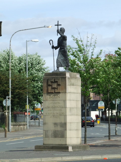
Saint Mirin was born in 565, is also known as Mirren of Benchor (now called Bangor), Merinus, Merryn and Meadhrán. The patron saint of the town and Roman Catholic diocese of Paisley, Scotland, he was the founder of a religious community which grew to become Paisley Abbey. The shrine of this saint in the abbey became a centre of pilgrimage. A contemporary of the better known St Columba of Iona and disciple of Saint Comgall, he was prior of Bangor Abbey in County Down, Ireland before making his missionary voyage to Scotland. He is venerated in both Ireland and Scotland and in the Orthodox tradition. History and legend Much of what is known about Mirin is difficult to separate from fable, however it is believed that he was of noble birth. While still a young boy, his mother took him to the monastery of Bangor Abbey in County Down in the north east of Ireland, where he was placed under the care of St. Comgall. St Mirin later took oversight of the monastery and thus became the p ... [...More Info...] [...Related Items...] OR: [Wikipedia] [Google] [Baidu] |
Inchcailloch
Inchcailloch ( gd, Innis na Cailleach) is an islet on Loch Lomond in Scotland. It is at its highest point. It is also known to some as Inchebroida. The name Inchcailloch means "Isle of the old woman" or "Isle of the Cowled (Hooded) Woman" in the Scottish Gaelic language. Saint Kentigerna went to Scotland from Ireland to preach and spread Christianity and the island is thought to be named after her. Geography and geology Inchmurrin, Creinch, Torrinch, and Inchcailloch all form part of the Highland boundary fault. There is a burial ground in the north of the island, and a bay, Port Bawn ( gd, Port Bàn; en, White Port), in the south. Like many of the Loch Lomond islands, it is quite heavily wooded. Transport There is a passenger ferry across the short channel separating it from Balmaha on the mainland. As a result, it receives more visitors than most of the Loch Lomond islands, currently 20,000 visitors per year. There is a camp site in the south at Port Bawn and a nature ... [...More Info...] [...Related Items...] OR: [Wikipedia] [Google] [Baidu] |
Clan Colquhoun
Clan Colquhoun ( gd, Clann a' Chombaich ) is a Scottish clan. History Origins of the clan The lands of the clan Colquhoun are on the shores of Loch Lomond. During the reign of Alexander II, Umphredus de Kilpatrick received from Malduin, Earl of Lennox, the estates of Colquhoun, Auchentorily and Dumbuck. The clan chief's early stronghold was at Dunglass Castle, which is perched on a rocky promontory by the River Clyde. Dunglass was also close to the royal Dumbarton Castle, of which later Colquhoun chiefs were appointed governors and keepers. The chief's title was that of the Barony of Luss which came to the clan when Sir Robert of Colquhoun married the heiress of the Lord of Luss in about 1368. 15th and 16th centuries During the minority of James II of Scotland, Sir John Colquhoun was appointed governor of the royal Dumbarton Castle. However he was murdered during a raid at Inchmurrin in 1439. He was succeeded by his son, another Sir John, who rose to be Comptroller ... [...More Info...] [...Related Items...] OR: [Wikipedia] [Google] [Baidu] |
West Dunbartonshire
West Dunbartonshire ( sco, Wast Dunbairtonshire; gd, Siorrachd Dhùn Breatann an Iar, ) is one of the 32 local government council areas of Scotland. The area lies to the west of the City of Glasgow and contains many of Glasgow's commuter towns and villages. West Dunbartonshire also borders Argyll and Bute, East Dunbartonshire, Renfrewshire and Stirling. The area was formed on 1 April 1996 from part of the former Strathclyde Region, namely the entire district of Clydebank, and the Dumbarton district less the Helensburgh area. In the Local Government etc. (Scotland) Act 1994 that created the council area its name was Dumbarton and Clydebank; however the council, elected as a shadow authority in 1995, resolved to change the name of the area to West Dunbartonshire. The West Dunbartonshire area is essentially composed of three parts: the towns of Clydebank, Dumbarton and the Vale of Leven District. The council is administered from 16 Church Street in Dumbarton (the old Dumbarto ... [...More Info...] [...Related Items...] OR: [Wikipedia] [Google] [Baidu] |
Falkland Palace
Falkland Palace, in Falkland, Fife, Scotland, is a royal palace of the Scottish Kings. It was one of the favourite places of Mary, Queen of Scots, providing an escape from political and religious turmoil. Today it is under the stewardship of Ninian Stuart, who delegates most of his duties to The National Trust for Scotland. The Chapel Royal in the Palace is dedicated to Thomas the Apostle, and is also open to the public and reserved for Catholic worship. History Early years A hunting lodge existed on the site in the 12th century. The lodge was expanded in the 13th century and became a castle which was owned by the Earls of Fife – the famous Clan MacDuff. The castle was built here because the site sits on a slight hill which could be defended. The surrounding land eventually became the Palace gardens. There was a great oak wood to the north between the royal stable and the River Eden, with many groves merging into the surrounding parkland. Timber was occasionally cut ... [...More Info...] [...Related Items...] OR: [Wikipedia] [Google] [Baidu] |


