|
Hundersfield
Hundersfield ( ; also more anciently known as Honersfield and Honnersfield) was a manor, parish and, from 1746, township, within the parish of Rochdale, in the hundred of Salford, England. It straddled the historic county boundary between Lancashire and the West Riding of Yorkshire. There are written references to the parish dating back to 1202. Hundersfield lay on high moorland around Blackstone Edge, containing the settlements of Todmorden, Walsden, Littleborough, Wardle, Smallbridge and parts of Rochdale Rochdale ( ) is a large town in Greater Manchester, England, at the foothills of the South Pennines in the dale on the River Roch, northwest of Oldham and northeast of Manchester. It is the administrative centre of the Metropolitan Borough .... The name Hundersfield is a corruption of Honorsfield; and that was derived from the word "Honore", signifying a Saxon lord. Hundersfield was originally one of four townships within Rochdale, but was itself split into ... [...More Info...] [...Related Items...] OR: [Wikipedia] [Google] [Baidu] |
Rochdale (ancient Parish)
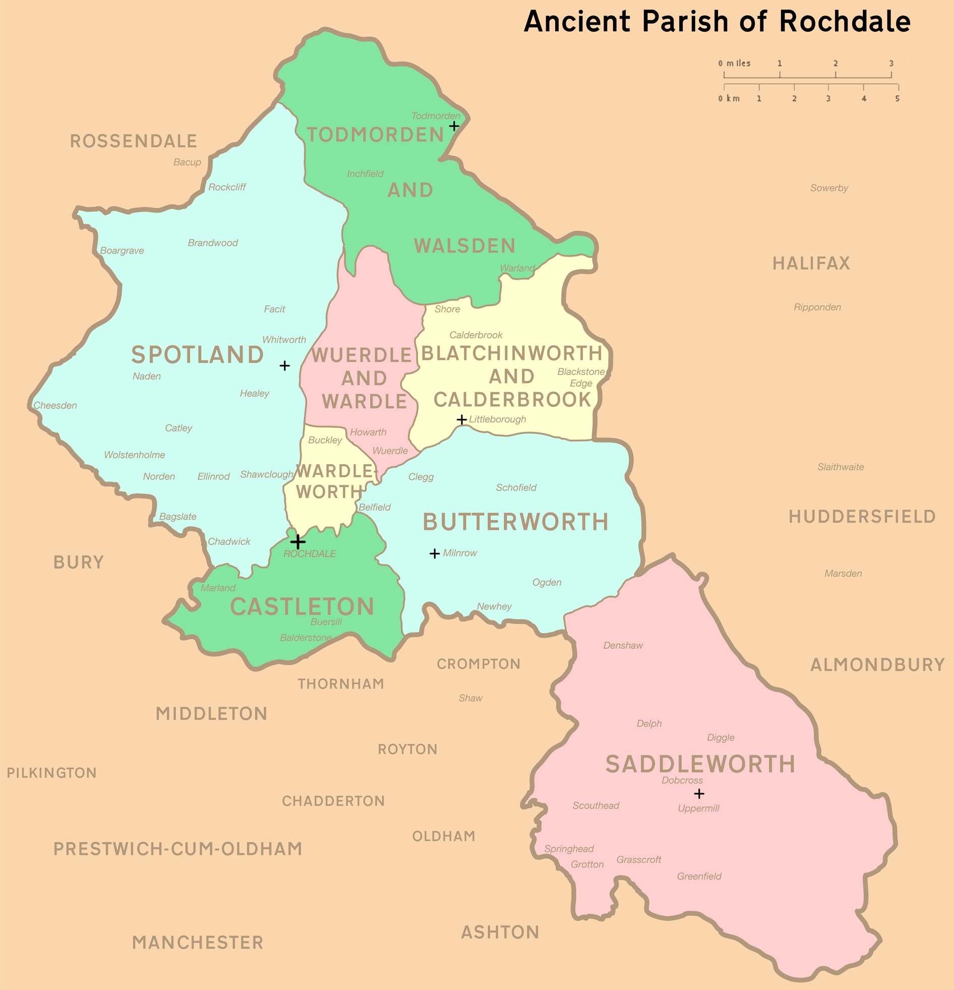
Rochdale was an ecclesiastical parish of early-medieval origin in northern England, administered from the Church of St Chad, Rochdale. At its zenith, it occupied of land amongst the South Pennines, and straddled the historic county boundary between Lancashire and the West Riding of Yorkshire. To the north and north-west was the parish of Whalley; to the southwest was the parish of Bury; to the south was Middleton and Prestwich-cum-Oldham. Anciently a dependency of Whalley Abbey, the parish of Rochdale is believed to be of Anglo-Saxon origin, as evidenced by historical documentation, toponymy and its dedication to Chad of Mercia. Urbanisation, population shifts, and local government reforms all contributed towards the gradual alteration and ultimate dissolution of the historic parish boundaries; the social welfare functions of the parish were broadly superseded by the English Poor Laws and new units of local governance, such as the County Borough of Rochdale and the Milnrow Ur ... [...More Info...] [...Related Items...] OR: [Wikipedia] [Google] [Baidu] |
Littleborough, Greater Manchester
Littleborough ( ) is a town in the Metropolitan Borough of Rochdale, Greater Manchester, England, in the upper Roch Valley by the foothills of the South Pennines, northeast of Rochdale and northeast of Manchester; Milnrow and the M62 motorway are to the south, and the rural uplands of Blackstone Edge to the east. In 2001, Littleborough, and its suburbs of Calderbrook, Shore and Smithy Bridge,. had a population of 13,807. Within the boundaries of the historic county of Lancashire, Littleborough and its surroundings have provided evidence of Neolithic, Celtic, Roman and Anglo-Saxon activity in the area. During the Middle Ages, Littleborough was a hamlet in the manor of Hundersfield, parish of Rochdale and hundred of Salford.. It was focussed upon the junction of two ancient routes over the Pennines — one of which may have been a Roman road — that joined to cross the River Roch. By 1472, Littleborough consisted of a chapel, a cluster of cottages, and an inn, and its inha ... [...More Info...] [...Related Items...] OR: [Wikipedia] [Google] [Baidu] |
Salford (hundred)
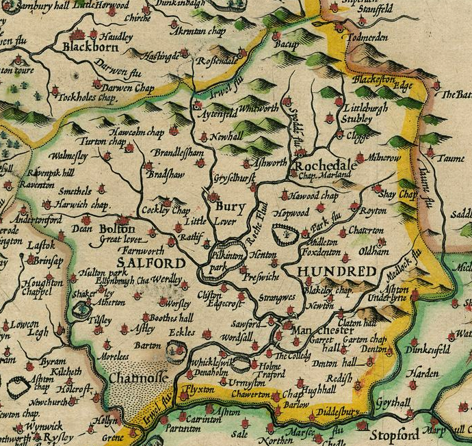
The Salford Hundred (also known as Salfordshire) was one of the subdivisions of the historic county of Lancashire, in Northern England (see:Hundred (county division). Its name alludes to its judicial centre being the township of Salford (the suffix ''-shire'' meaning the territory was appropriated to the prefixed settlement). It was also known as the Royal Manor of Salford and the Salford wapentake.. Origins The Manor or Hundred of Salford had Anglo-Saxon origins. The ''Domesday Book'' recorded that the area was held in 1066 by Edward the Confessor. Salford was recorded as part of the territory of ''Inter Ripam et Mersam'' or "Between Ribble and Mersey", and it was included with the information about Cheshire, though it cannot be said clearly to have been part of Cheshire. The area became a subdivision of the County Palatine of Lancaster (or Lancashire) on its creation in 1182. Salford Hundred Court In spite of its incorporation into Lancashire, Salford Hundred retained a se ... [...More Info...] [...Related Items...] OR: [Wikipedia] [Google] [Baidu] |
Rochdale
Rochdale ( ) is a large town in Greater Manchester, England, at the foothills of the South Pennines in the dale on the River Roch, northwest of Oldham and northeast of Manchester. It is the administrative centre of the Metropolitan Borough of Rochdale, which had a population of 211,699 in the 2011 census. Located within the historic boundaries of the county of Lancashire. Rochdale's recorded history begins with an entry in the Domesday Book of 1086 under "Recedham Manor". The ancient parish of Rochdale was a division of the hundred of Salford and one of the largest ecclesiastical parishes in England, comprising several townships. By 1251, Rochdale had become important enough to have been granted a Royal charter. Rochdale flourished into a centre of northern England's woollen trade, and by the early 18th century was described as being "remarkable for many wealthy merchants". Rochdale rose to prominence in the 19th century as a mill town and centre for textile manufacture ... [...More Info...] [...Related Items...] OR: [Wikipedia] [Google] [Baidu] |
Wardle, Greater Manchester
Wardle (; pop. 7,092) is a village near Littleborough within the Metropolitan Borough of Rochdale, in Greater Manchester, England. It lies amongst the foothills of the South Pennines, east-southeast of Whitworth, north-northwest of Rochdale and north-northeast of the city of Manchester. Historically a part of Lancashire, Wardle and its surroundings have provided archaeological evidence of Mesolithic activity in the area. The name Wardle is said to be derived from "Ward Hill", implying "fortified place". Brown Wardle Hill overlooks the village from the north, its name being derived from the Celtic word ''bron'' meaning "round". During the Middle Ages Wardle was a small centre of domestic flannel and woollen cloth production, and many of the original weavers' cottages survive today as listed buildings. Wardle, the most northerly settlement in Greater Manchester,Rochdale Metropolitan Borough Council (N.D.), p. 33. encompasses small parts of Smallbridge and Dearnley � ... [...More Info...] [...Related Items...] OR: [Wikipedia] [Google] [Baidu] |
Todmorden
Todmorden ( ; ) is a market town and civil parishes in England, civil parish in the Upper Calder Valley in Calderdale, West Yorkshire, England. It is north-east of Manchester, south-east of Burnley and west of Halifax, West Yorkshire, Halifax. In 2011 it had a population of 15,481. Todmorden is at the confluence of three steep-sided Pennines, Pennine valleys and is surrounded by moorlands with outcrops of Aeolian processes, sandblasted gritstone. The Historic counties of England, historic boundary between Yorkshire and Lancashire is the River Calder, West Yorkshire, River Calder and its tributary, Walsden Water, which run through the town. The administrative border was altered by the Local Government Act 1888 placing the whole of the town within the West Riding of Yorkshire, West Riding. The town is served by and railway stations. History Toponymy The name Todmorden first appears in 1641. The town had earlier been called Tottemerden, Totmardene, Totmereden or Totmerd ... [...More Info...] [...Related Items...] OR: [Wikipedia] [Google] [Baidu] |
Blackstone Edge
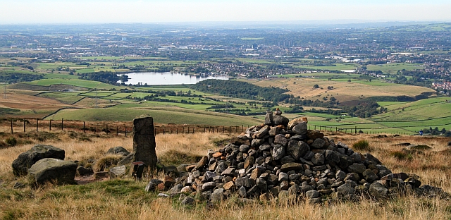
Blackstone Edge ( ) is a gritstone escarpment at 472 m (1,549 feet) above sea level in the Pennine hills surrounded by moorland on the boundary between Greater Manchester and West Yorkshire in England. History Crossing the escarpment is Blackstone Edge Long Causeway, also known as Blackstone Edge Roman Road, a partially paved road on the Greater Manchester side, becoming a holloway through peat as it runs into Yorkshire. The Blackstone Edge Long Causeway was originally thought to be of Roman origin until investigations by James Maxim, who proposed the theory that it was actually a 1735 turnpike or packhorse route. This theory was widely accepted until 2012 when investigations by Archaeological Services WYAS led them to conclude that "The archaeological surface evidence...suggests that the route of the road is unlikely to have originated as part of a turnpike scheme as probable medieval and post-medieval features, including a packhorse road, appear to overlie the substantia ... [...More Info...] [...Related Items...] OR: [Wikipedia] [Google] [Baidu] |
History Of The Metropolitan Borough Of Rochdale
History (derived ) is the systematic study and the documentation of the human activity. The time period of event before the invention of writing systems is considered prehistory. "History" is an umbrella term comprising past events as well as the memory, discovery, collection, organization, presentation, and interpretation of these events. Historians seek knowledge of the past using historical sources such as written documents, oral accounts, art and material artifacts, and ecological markers. History is not complete and still has debatable mysteries. History is also an academic discipline which uses narrative to describe, examine, question, and analyze past events, and investigate their patterns of cause and effect. Historians often debate which narrative best explains an event, as well as the significance of different causes and effects. Historians also debate the nature of history as an end in itself, as well as its usefulness to give perspective on the problems of the p ... [...More Info...] [...Related Items...] OR: [Wikipedia] [Google] [Baidu] |
Saxons
The Saxons ( la, Saxones, german: Sachsen, ang, Seaxan, osx, Sahson, nds, Sassen, nl, Saksen) were a group of Germanic * * * * peoples whose name was given in the early Middle Ages to a large country (Old Saxony, la, Saxonia) near the North Sea coast of northern Germania, in what is now Germany. In the late Roman Empire, the name was used to refer to Germanic coastal raiders, and as a name similar to the later "Viking". Their origins are believed to be in or near the German North Sea coast where they appear later, in Carolingian times. In Merovingian times, continental Saxons had been associated with the activity and settlements on the coast of what later became Normandy. Their precise origins are uncertain, and they are sometimes described as fighting inland, coming into conflict with the Franks and Thuringians. There is possibly a single classical reference to a smaller homeland of an early Saxon tribe, but its interpretation is disputed. According to this proposal, the S ... [...More Info...] [...Related Items...] OR: [Wikipedia] [Google] [Baidu] |
Smallbridge, Greater Manchester
Smallbridge is a district of Rochdale in Greater Manchester, England. It lies at the foothills of the Pennines, in the northeast of Rochdale, contiguous with Buckley, and to the south of the village of Wardle. The Rochdale ward is called Smallbridge and Firgrove. This ward had a population of 11,469 at the 2011 Census. See also *Listed buildings in Wardle, Greater Manchester Wardle, Greater Manchester, Wardle is a village in the Metropolitan Borough of Rochdale, Greater Manchester, England, and it is civil parish, unparished. The village, together with the nearby settlement of Smallbridge, Greater Manchester, Smallbr ... References External linksWardle and Smallbridge History GroupHome page of the local history group Areas of Rochdale {{GreaterManchester-geo-stub ... [...More Info...] [...Related Items...] OR: [Wikipedia] [Google] [Baidu] |
Township (England)
In England, a township (Latin: ''villa'') is a local division or district of a large parish containing a village or small town usually having its own church. A township may or may not be coterminous with a chapelry, manor, or any other minor area of local administration. The township is distinguished from the following: *Vill: traditionally, among legal historians, a ''vill'' referred to the tract of land of a rural community, whereas ''township'' was used when referring to the tax and legal administration of that community. *Chapelry: the 'parish' of a chapel (a church without full parochial functions). *Tithing: the basic unit of the medieval Frankpledge system. 'Township' is, however, sometimes used loosely for any of the above. History In many areas of England, the basic unit of civil administration was the parish, generally identical with the ecclesiastical parish. However, in some cases, particularly in Northern England, there was a lesser unit called a township, being a ... [...More Info...] [...Related Items...] OR: [Wikipedia] [Google] [Baidu] |
Walsden
Walsden (; ) is a large village in the civil parish In England, a civil parish is a type of administrative parish used for local government. It is a territorial designation which is the lowest tier of local government below districts and counties, or their combined form, the unitary authority ... of Todmorden in the Metropolitan Borough of Calderdale, West Yorkshire, England, though Historic counties of England, historically partially administered in Lancashire (the Walsden Water as tributary to the River Calder, West Yorkshire, Calder serving as the county boundary), and close to the modern boundary with Greater Manchester. It lies along the A6033 road (Great Britain), A6033 Keighley to Littleborough road in the Walsden Valley, a branch of the Upper Calder Valley, and is south of Todmorden and north of Littleborough, Greater Manchester, Littleborough. Overview Walsden railway station, on the Leeds-Todmorden-Manchester line, originally opened in 1841 and re-opened 10 ... [...More Info...] [...Related Items...] OR: [Wikipedia] [Google] [Baidu] |


.jpg)

