|
Herreroland
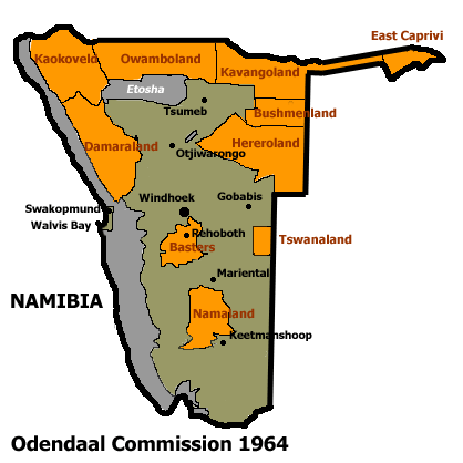
Hereroland was the first bantustan in South West Africa (present day Namibia), intended by the apartheid government to be a self-government, self-governing homeland for the Herero people. It was set up in 1968. Hereroland, like other homelands in South West Africa, was abolished in May 1989 at the start of the Namibian War of Independence, transition to independence. See also *Apartheid *Leaders of Hereroland References History of Namibia Bantustans in South West Africa Herero people States and territories established in 1968 States and territories disestablished in 1989 1968 establishments in South West Africa {{Namibia-hist-stub ... [...More Info...] [...Related Items...] OR: [Wikipedia] [Google] [Baidu] |
Bantustan
A Bantustan (also known as Bantu homeland, black homeland, black state or simply homeland; ) was a territory that the National Party administration of South Africa set aside for black inhabitants of South Africa and South West Africa (now Namibia), as part of its policy of apartheid. By extension, outside South Africa the term refers to regions that lack any real legitimacy, consisting often of several unconnected enclaves, or which have emerged from national or international gerrymandering.Macmillan DictionaryBantustan, "1. one of the areas in South Africa where black people lived during the apartheid system; 2. SHOWING DISAPPROVAL any area where people are forced to live without full civil and political rights." The term, first used in the late 1940s, was coined from Bantu' (meaning "people" in some of the Bantu languages) and '' -stan'' (a suffix meaning "land" in the Persian language and some Persian-influenced languages of western, central, and southern Asia). It subs ... [...More Info...] [...Related Items...] OR: [Wikipedia] [Google] [Baidu] |
Okakarara
Okakarara is a town in Otjozondjupa Region, Namibia, located southeast of Waterberg National Park. It has an estimated population of 7,000 and is currently growing by 1,500 inhabitants annually. Okakarara consists of the residential areas of ''Pamue'', the former whites-only area, and ''Okakarara Proper'', the former black residential area. It is the district capital of the Okakarara electoral constituency that includes surrounding settlements. History The first house was built by Salathiel Kambamba Kambazembi and Reinard Tjerije who arrived in the area in 1923. The settlement grew over time and was proclaimed a town in 1992. Okakarara became the centre of the Herero Tribal Authority in the early 1970s. Economy and infrastructure The town further features a secondary school, a government hospital, a vocational training centre, and an abattoir. Since 2007, Okakarara hosts the annual Okakarara trade fair, a four-day event to bring the breeders of the communal land area around ... [...More Info...] [...Related Items...] OR: [Wikipedia] [Google] [Baidu] |
South African Rand
The South African rand, or simply the rand, ( sign: R; code: ZAR) is the official currency of the Southern African Common Monetary Area: South Africa, Namibia (alongside the Namibian dollar), Lesotho (alongside the Lesotho loti) and Eswatini (alongside the Swazi lilangeni). It is subdivided into 100 cents (sign: "c"). The South African rand is legal tender in the Common Monetary Area member states of Namibia, Lesotho and Eswatini, with these three countries also having their own national currency (the dollar, the loti and the lilangeni respectively) pegged with the rand at parity and still widely accepted as substitutes. The rand was also legal tender in Botswana until 1976, when the pula replaced the rand at par. Etymology The rand takes its name from the Witwatersrand ("white waters' ridge" in English, ''rand'' being the Dutch and Afrikaans word for 'ridge'), the ridge upon which Johannesburg is built and where most of South Africa's gold deposits were found. In Eng ... [...More Info...] [...Related Items...] OR: [Wikipedia] [Google] [Baidu] |
Plan Odendaal
A plan is typically any diagram or list of steps with details of timing and resources, used to achieve an objective to do something. It is commonly understood as a temporal set of intended actions through which one expects to achieve a goal. For spatial or planar topologic or topographic sets see map. Plans can be formal or informal: * Structured and formal plans, used by multiple people, are more likely to occur in projects, diplomacy, careers, economic development, military campaigns, combat, sports, games, or in the conduct of other business. In most cases, the absence of a well-laid plan can have adverse effects: for example, a non-robust project plan can cost the organization time and money. * Informal or ad hoc plans are created by individuals in all of their pursuits. The most popular ways to describe plans are by their breadth, time frame, and specificity; however, these planning classifications are not independent of one another. For instance, there is a close re ... [...More Info...] [...Related Items...] OR: [Wikipedia] [Google] [Baidu] |
Bantustan
A Bantustan (also known as Bantu homeland, black homeland, black state or simply homeland; ) was a territory that the National Party administration of South Africa set aside for black inhabitants of South Africa and South West Africa (now Namibia), as part of its policy of apartheid. By extension, outside South Africa the term refers to regions that lack any real legitimacy, consisting often of several unconnected enclaves, or which have emerged from national or international gerrymandering.Macmillan DictionaryBantustan, "1. one of the areas in South Africa where black people lived during the apartheid system; 2. SHOWING DISAPPROVAL any area where people are forced to live without full civil and political rights." The term, first used in the late 1940s, was coined from Bantu' (meaning "people" in some of the Bantu languages) and '' -stan'' (a suffix meaning "land" in the Persian language and some Persian-influenced languages of western, central, and southern Asia). It subs ... [...More Info...] [...Related Items...] OR: [Wikipedia] [Google] [Baidu] |
South West Africa
South West Africa ( af, Suidwes-Afrika; german: Südwestafrika; nl, Zuidwest-Afrika) was a territory under South African administration from 1915 to 1990, after which it became modern-day Namibia. It bordered Angola (Portuguese colony before 1975), Botswana ( Bechuanaland before 1966), South Africa, and Zambia (Northern Rhodesia before 1964). Previously the German colony of South West Africa from 1884–1915, it was made a League of Nations mandate of the Union of South Africa following Germany's defeat in the First World War. Although the mandate was abolished by the United Nations in 1966, South African control over the territory continued despite its illegality under international law. The territory was administered directly by the South African government from 1915 to 1978, when the Turnhalle Constitutional Conference laid the groundwork for semi-autonomous rule. During an interim period between 1978 and 1985, South Africa gradually granted South West Africa a limited for ... [...More Info...] [...Related Items...] OR: [Wikipedia] [Google] [Baidu] |
Namibia
Namibia (, ), officially the Republic of Namibia, is a country in Southern Africa. Its western border is the Atlantic Ocean. It shares land borders with Zambia and Angola to the north, Botswana to the east and South Africa to the south and east. Although Kazungula, it does not border Zimbabwe, less than 200 metres (660 feet) of the Botswanan right bank of the Zambezi, Zambezi River separates the two countries. Namibia gained independence from South Africa on 21 March 1990, following the Namibian War of Independence. Its capital and largest city is Windhoek. Namibia is a member state of the United Nations (UN), the Southern African Development Community (SADC), the African Union (AU) and the Commonwealth of Nations. The driest country in sub-Saharan Africa, Namibia has been inhabited since pre-historic times by the San people, San, Damara people, Damara and Nama people. Around the 14th century, immigration, immigrating Bantu peoples arrived as part of the Bantu expansion. Since ... [...More Info...] [...Related Items...] OR: [Wikipedia] [Google] [Baidu] |
Self-government
__NOTOC__ Self-governance, self-government, or self-rule is the ability of a person or group to exercise all necessary functions of regulation without intervention from an external authority. It may refer to personal conduct or to any form of institution, such as family units, social groups, affinity groups, legal bodies, industry bodies, religions, and political entities of various degree. Self-governance is closely related to various philosophical and socio-political concepts such as autonomy, independence, self-control, self-discipline, and sovereignty. In the context of nation states, self-governance is called national sovereignty which is an important concept in international law. In the context of administrative division, a self-governing territory is called an autonomous region. Self-governance is also associated with political contexts in which a population or demographic becomes independent from colonial rule, absolute government, absolute monarchy or any governmen ... [...More Info...] [...Related Items...] OR: [Wikipedia] [Google] [Baidu] |
Herero People
The Herero ( hz, Ovaherero) are a Bantu ethnic group inhabiting parts of Southern Africa. There were an estimated 250,000 Herero people in Namibia in 2013. They speak Otjiherero, a Bantu language. Though the Herero primarily reside in Namibia, there are also significant populations in Botswana and Angola. In Botswana, the Hereros or Ovaherero are mostly found in Maun and some villages surrounding Maun. These villages among others are Sepopa, Toromuja, Karee and Etsha. Some of them are at Mahalapye. In the South eastern part of Botswana they are at Pilane. There are also a few of them in the Kgalagadi South, that is Tsabong, Omawaneni, Draaihoek and Makopong Villages. Overview Unlike most Bantu, who are primarily subsistence farmers,Immaculate N. Kizza, ''The Oral Tradition of the Baganda of Uganda: A Study and Anthology of Legends, Myths, Epigrams and Folktales'' p. 21: "The Bantu were, and still are, primarily subsistence farmers who would settle in areas, clear land, or ... [...More Info...] [...Related Items...] OR: [Wikipedia] [Google] [Baidu] |
Namibian War Of Independence
The South African Border War, also known as the Namibian War of Independence, and sometimes denoted in South Africa as the Angolan Bush War, was a largely asymmetric conflict that occurred in Namibia (then South West Africa), Zambia, and Angola from 26 August 1966 to 21 March 1990. It was fought between the South African Defence Force (SADF) and the People's Liberation Army of Namibia (PLAN), an armed wing of the South West African People's Organisation (SWAPO). The South African Border War resulted in some of the largest battles on the African continent since World War II and was closely intertwined with the Angolan Civil War. Following several years of unsuccessful petitioning through the United Nations and the International Court of Justice for Namibian independence from South Africa, SWAPO formed the PLAN in 1962 with material assistance from the Soviet Union, China, and sympathetic African states such as Tanzania, Ghana, and Algeria. Fighting broke out between PLAN and th ... [...More Info...] [...Related Items...] OR: [Wikipedia] [Google] [Baidu] |
Apartheid
Apartheid (, especially South African English: , ; , "aparthood") was a system of institutionalised racial segregation that existed in South Africa and South West Africa (now Namibia) from 1948 to the early 1990s. Apartheid was characterised by an authoritarian political culture based on ''baasskap'' (boss-hood or boss-ship), which ensured that South Africa was dominated politically, socially, and economically by the nation's minority white population. According to this system of social stratification, white citizens had the highest status, followed by Indians and Coloureds, then black Africans. The economic legacy and social effects of apartheid continue to the present day. Broadly speaking, apartheid was delineated into ''petty apartheid'', which entailed the segregation of public facilities and social events, and ''grand apartheid'', which dictated housing and employment opportunities by race. The first apartheid law was the Prohibition of Mixed Marriages ... [...More Info...] [...Related Items...] OR: [Wikipedia] [Google] [Baidu] |
Leaders Of Hereroland
The Herero people of Namibia are ruled by traditional leaders, the highest office is that of the ''Paramount Chief''. During part of the South African apartheid administration in South West Africa, when Hereroland was a bantustan (designated area for Herero settlement), they additionally had a political representative to the South African Administration, which was decoupled from chieftaincy in 1980. Fast forward a few years after Independence in 1990, there are many traditional authoritiein terms of Traditional Authorities Act, 1995 (Act No. 25 of 2000 as amended) Since the implementation of the Traditional Authorities Act in 1995, the independent government of the Republic of Namibia sought to recognize individual royal houses within the Ovaherero communities as stand-alone traditional authorities, and denied recognition the overarching Ovaherero Traditional Authority (OTA) that has been in existence since 1863. Paramount Chief Riruako fought for recognition and the Authority was th ... [...More Info...] [...Related Items...] OR: [Wikipedia] [Google] [Baidu] |


