|
Hauran
The Hauran ( ar, حَوْرَان, ''Ḥawrān''; also spelled ''Hawran'' or ''Houran'') is a region that spans parts of southern Syria and northern Jordan. It is bound in the north by the Ghouta oasis, eastwards by the al-Safa field, to the south by Jordan's desert steppe and to the west by the Golan Heights. Traditionally, the Hauran consists of three subregions: the Nuqrah and Jaydur plains, the Jabal al-Druze massif, and the Lajat volcanic field. The population of the Hauran is largely Arab, but religiously heterogeneous; most inhabitants of the plains are Sunni Muslims belonging to large agrarian clans, while Druze form the majority in the eponymous Jabal al-Druze and a significant Greek Orthodox and Greek Catholic minority inhabit the western foothills of Jabal al-Druze. The region's largest towns are Daraa, al-Ramtha and al-Suwayda. From the mid-1st century BCE, the region was governed by the Roman Empire's Herodian and Nabatean client kings until it was formal ... [...More Info...] [...Related Items...] OR: [Wikipedia] [Google] [Baidu] |
Lajat
The Lajat (/ ALA-LC: ''al-Lajāʾ''), also spelled ''Lejat'', ''Lajah'', ''el-Leja'' or ''Laja'', is the largest lava field in southern Syria, spanning some 900 square kilometers. Located about southeast of Damascus, the Lajat borders the Hauran plain to the west and the foothills of Jabal al-Druze to the south. The average elevation is between 600 and 700 meters above sea level, with the highest volcanic cone being 1,159 meters above sea level. Receiving little annual rainfall, the Lajat is largely barren, though there are scattered patches of arable land in some of its depressions. The region has been known by a number of names throughout its history, including "Argob" ( ''’Argōḇ'',) in the Hebrew Bible and "Trachonitis" () by the Greeks, a name under which it is mentioned in the Gospel of Luke (). Long inhabited by Arab groups, it saw development under the Romans, who built a road through the center of the region connecting it with the empire's province of Syria. The ... [...More Info...] [...Related Items...] OR: [Wikipedia] [Google] [Baidu] |
Druze
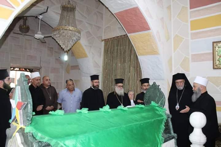
The Druze (; ar, دَرْزِيٌّ, ' or ', , ') are an Arabic-speaking esoteric ethnoreligious group from Western Asia who adhere to the Druze faith, an Abrahamic, monotheistic, syncretic, and ethnic religion based on the teachings of Hamza ibn Ali ibn Ahmad and ancient Greek philosophers like Plato, Aristotle, Pythagoras, and Zeno of Citium. Adherents of the Druze religion call themselves " the Monotheists" or "the Unitarians" (''al-Muwaḥḥidūn''). The Epistles of Wisdom is the foundational and central text of the Druze faith. The Druze faith incorporates elements of Isma'ilism, Christianity, Gnosticism, Neoplatonism, Zoroastrianism, Buddhism, Hinduism, Pythagoreanism, and other philosophies and beliefs, creating a distinct and secretive theology based on an esoteric interpretation of scripture, which emphasizes the role of the mind and truthfulness. Druze believe in theophany and reincarnation. Druze believe that at the end of the cycle of rebirth, which i ... [...More Info...] [...Related Items...] OR: [Wikipedia] [Google] [Baidu] |
Nabatean Kingdom
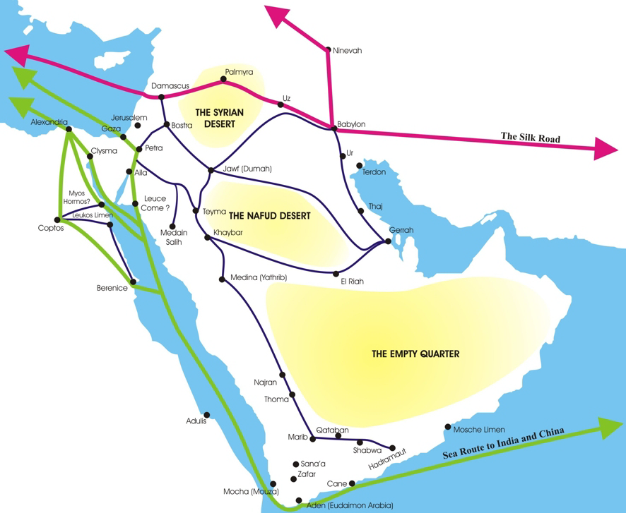
The Nabataean Kingdom ( Nabataean Aramaic: 𐢕𐢃𐢋𐢈 ''Nabāṭū''), also named Nabatea (), was a political state of the Arab Nabataeans during classical antiquity. The Nabataean Kingdom controlled many of the trade routes of the region, amassing large wealth and drawing the envy of its neighbors. It stretched south along the Red Sea coast into the Hejaz, up as far north as Damascus, which it controlled for a short period (85–71 BC). Nabataea remained an independent political entity from the mid-3rd century BC until it was annexed in AD 106 by the Roman Empire, which renamed it Arabia Petraea. History Nabataeans The Nabataeans were one among several nomadic Bedouin tribes that roamed the Arabian Desert and moved with their herds to wherever they could find pasture and water. They became familiar with their area as seasons passed, and they struggled to survive during bad years when seasonal rainfall diminished. Although the Nabataeans were initially embedded in A ... [...More Info...] [...Related Items...] OR: [Wikipedia] [Google] [Baidu] |
Daraa
Daraa ( ar, دَرْعَا, Darʿā, Levantine Arabic: , also Darʿā, Dara’a, Deraa, Dera'a, Dera, Derʿā and Edrei; means "''fortress''", compare Dura-Europos) is a city in southwestern Syria, located about north of the border with Jordan. It is the capital of Daraa Governorate, historically part of the ancient Hauran region. The city is located about south of Damascus on the Damascus–Amman highway, and is used as a stopping station for travelers. Nearby localities include Umm al-Mayazen and Nasib to the southeast, Al-Naimah to the east, Ataman to the north, al-Yadudah to the northwest and Ramtha, Jordan to the southwest. According to the Syrian Central Bureau of Statistics, Daraa had a population of 97,969 in the 2004 census. It is the administrative center of a ''nahiyah'' ("sub-district") which contains eight localities with a collective population of 146,481 in 2004. By the 3rd-century, it gained the status of a ''polis'' (self-governed city). Roman histor ... [...More Info...] [...Related Items...] OR: [Wikipedia] [Google] [Baidu] |
Ar Ramtha
Ar-Ramtha ( ar, الرَّمثا, ar-Ramṯā), colloquially transliterated as Ar-Romtha ( ar, الرُّمثا, ar-Rumṯā), is a city situated in the far northwest of Jordan near the border with Syria. It covers 40 km2 on a plain 30 km northeast of the Jordan River and Irbid. In the 2017, Ar-Ramtha had a population of approximately 164,211, making it the eleventh largest city in Jordan, and the second in Irbid Governorate, and the city has grown since then. It is part of the Ar-Ramthā district of the Irbid Governorate. Etymology The origin of the name Ar-Ramtha is debated. Some claim it is named after a local desert plant, al-ramath ( ar, الرمثا). Many biblical archaeologists identify Ar-Ramtha with the ancient Israelite city of Ramoth-Gilead, Hebrew for "Heights of Gilead"; in that case, the present-day Arabic name might preserve the Biblical Hebrew one. During the Roman and Byzantine periods, Ar-Ramtha was known as Ramatha. History Prehistory The stable ... [...More Info...] [...Related Items...] OR: [Wikipedia] [Google] [Baidu] |
Batanea
Batanaea or Batanea (the Hellenized/Latinised form of Bashan) was an area of the Biblical Holy Land, north-east of the Jordan River, to the west of Trachonitis. History Bataneaea was one of the four post- Exile divisions of the area of Bashan. Today, Batanaea is more commonly called Nuqrah, and runs north-south along the east side of the Lejah (Trachonitis) and the Hauran (Auranitis), from Salkhad on the south, to Tells Khaledyeh and Asfar on the north. It is, on average, 12 miles wide, and for 30 miles along it extends the Gebel Hauran, a range of hills, whose central plateau is 2670 ft. above sea level and whose highest point is 6400 ft. Its highest peak may be the "Hill of Basan" referred to in . In the 1st century BCE the land was acquired by Herod the Great. He established a Jewish community there of Jews from Babylon who were brought to Batanaea for the purpose of maintaining order against the banditry of the Trachonites. Upon Herod's death in 4 BCE, Batanaea p ... [...More Info...] [...Related Items...] OR: [Wikipedia] [Google] [Baidu] |
Ghouta
Ghouta ( ar, غُوطَةُ دِمَشْقَ / ALA-LC: ''Ḡūṭat Dimašq'') is a countryside and suburban area in southwestern Syria that surrounds the city of Damascus along its eastern and southern rim. Name Ghouta is the Arabic term (''ghuta'') for 'garden'. Geography The Ghouta is an oasis formed by the Barada River, as its waters flow east of Mount Qasioun, and its seven tributaries. It surrounds the city of Damascus. To the east and south of the Ghouta lies the Marj plain, which forms a narrow belt of fields, and south of that lies the Hauran plain. The Barada River Valley borders the Ghouta to the northeast. The area north of the Ghouta is less fertile and eventually desolate hill country. To the west of the region is the Anti-Lebanon Mountains. The Ghouta is historically the most celebrated 'green zone' (a verdant, fertile area around an urban center) in the Levant, according to the historian Beshara Doumani. He also notes that its fame in this regard persist ... [...More Info...] [...Related Items...] OR: [Wikipedia] [Google] [Baidu] |
Al-Suwayda
As-Suwayda ( ar, ٱلسُّوَيْدَاء / ALA-LC romanization: ''as-Suwaydāʾ''), also spelled ''Sweida'' or ''Swaida'', is a mainly Druze city located in southwestern Syria, close to the border with Jordan. It is the capital of As-Suwayda Governorate, one of Syria's 14 governorates, bordering Jordan in the South and Daraa Governorate in the West and Rif Dimashq Governorate in the north and east. The city is referred to by some as "Little Venezuela" due to the city's influx of affluent Venezuelan Syrian immigrants. Demographics and population The inhabitants of the city are mainly Druze with a prominent Greek Orthodox Christians and Sunni Muslim minority. The population of As-Suwayda Governorate is 313,231 (2004 census). History Ancient and Medieval eras The city was founded by the Nabataeans as Suada. It became known as Dionysias Soada ( grc, Διονῡσιάς) in the Hellenistic period and the Roman Empire, for the god Dionysus, patron of wine - the city is ... [...More Info...] [...Related Items...] OR: [Wikipedia] [Google] [Baidu] |
Arab
The Arabs (singular: Arab; singular ar, عَرَبِيٌّ, DIN 31635: , , plural ar, عَرَب, DIN 31635, DIN 31635: , Arabic pronunciation: ), also known as the Arab people, are an ethnic group mainly inhabiting the Arab world in Western Asia, North Africa, the Horn of Africa, and the western List of islands in the Indian Ocean, Indian Ocean islands (including the Comoros). An Arab diaspora is also present around the world in significant numbers, most notably in the Americas, Western Europe, Arabs in Turkey, Turkey, Arab Indonesians, Indonesia, and Iranian Arabs, Iran. In modern usage, the term "Arab" tends to refer to those who both Arab identity, carry that ethnic identity and speak Arabic as their native language. This contrasts with the narrower traditional definition, which refers to the descendants of the tribes of Arabia. The religion of Islam was developed in Arabia, and Classical Arabic serves as the language of Islamic literature. 93 percent of Arabs are Muslims ... [...More Info...] [...Related Items...] OR: [Wikipedia] [Google] [Baidu] |
Golan Heights
The Golan Heights ( ar, هَضْبَةُ الْجَوْلَانِ, Haḍbatu l-Jawlān or ; he, רמת הגולן, ), or simply the Golan, is a region in the Levant spanning about . The region defined as the Golan Heights differs between disciplines: as a geological and biogeographical region, the term refers to a basaltic plateau bordered by the Yarmouk River in the south, the Sea of Galilee and Hula Valley in the west, the Anti-Lebanon with Mount Hermon in the north and Wadi Raqqad in the east. As a geopolitical region, it refers to the border region captured from Syria by Israel during the Six-Day War of 1967; the territory has been occupied by the latter since then and was subject to a de facto Israeli annexation in 1981. This region includes the western two-thirds of the geological Golan Heights and the Israeli-occupied part of Mount Hermon. The earliest evidence of human habitation on the Golan dates to the Upper Paleolithic period. According to the Bible ... [...More Info...] [...Related Items...] OR: [Wikipedia] [Google] [Baidu] |
Melkite Greek Catholic Church
el, Μελχιτική Ελληνική Καθολική Εκκλησία , image = Melkite Greek Catholic Church, Damascus, Syria.jpg , imagewidth = 200px , alt = , caption = , abbreviation = , type = Antiochian , main_classification = Eastern Catholic , orientation = Melkite , scripture = , theology = Catholic Theology , polity = Episcopal , governance = , structure = , leader_title = Pope , leader_name = Francis , leader_title1 = Primate , leader_name1 = Patriarch Youssef Absi , leader_title2 = , leader_name2 = Cyril VI Tanas , leader_title3 = , leader_name3 = , fellowships_type = , fellowships = , fellowships_type1 = , fellowships1 = , division_type = , division = , division_type1 = , division1 = , div ... [...More Info...] [...Related Items...] OR: [Wikipedia] [Google] [Baidu] |
Syria
Syria ( ar, سُورِيَا or سُورِيَة, translit=Sūriyā), officially the Syrian Arab Republic ( ar, الجمهورية العربية السورية, al-Jumhūrīyah al-ʻArabīyah as-Sūrīyah), is a Western Asian country located in the Eastern Mediterranean and the Levant. It is a unitary republic that consists of 14 governorates (subdivisions), and is bordered by the Mediterranean Sea to the west, Turkey to the north, Iraq to the east and southeast, Jordan to the south, and Israel and Lebanon to the southwest. Cyprus lies to the west across the Mediterranean Sea. A country of fertile plains, high mountains, and deserts, Syria is home to diverse ethnic and religious groups, including the majority Syrian Arabs, Kurds, Turkmens, Assyrians, Armenians, Circassians, Albanians, and Greeks. Religious groups include Muslims, Christians, Alawites, Druze, and Yazidis. The capital and largest city of Syria is Damascus. Arabs are the largest ethnic group, ... [...More Info...] [...Related Items...] OR: [Wikipedia] [Google] [Baidu] |


