|
Hranice (Cheb District)
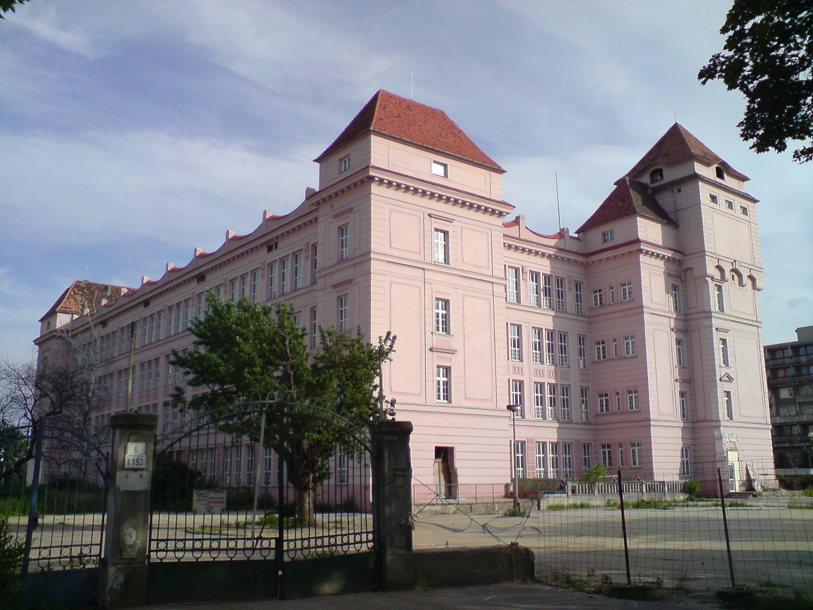
Hranice (; german: Roßbach) is a town in Cheb District in the Karlovy Vary Region of the Czech Republic. It has about 2,100 inhabitants. Administrative parts Villages of Pastviny, Studánka and Trojmezí are administrative parts of Hranice. Etymology The old German name ''Rossbach'' means "Horse brook", referring to the brook where first inhabitants watered their horses. Therefore the horse appears on the town's coat of arms and flag. In Czech, ''hranice'' means "border". Following the partition of Germany, a border tripoint (between Czechoslovakia, West and East Germany) was situated near the town, for which the village of Trojmezí (literally "Tripoint") is named. The village is also the tripoint of the three historical regions of Bohemia, Bavaria and Saxony. Geography Hranice is located about northwest of Cheb. It lies in the Aš Panhandle region, in the westernnmost part of the region, on the border with Germany. It neighbors the German municipalities of Bad Elster to the ... [...More Info...] [...Related Items...] OR: [Wikipedia] [Google] [Baidu] |
Obec
Obec (plural: ''obce'') is the Czech language, Czech and Slovak language, Slovak word for a municipality (in the Czech Republic, in Slovakia and abroad). The literal meaning of the word is "Intentional community, commune" or "community". It is the smallest administrative unit that is governed by elected representatives. Cities and towns are also municipalities. Definition Legal definition (according to the Czech code of law with similar definition in the Slovak code of law) is: ''"The municipality is a basic territorial self-governing community of citizens; it forms a territorial unit, which is defined by the boundary of the municipality."'' Every municipality is composed of one or more cadastre, cadastral areas. Every municipality is composed of one or more administrative parts, usually called town parts or villages. A municipality can have its own flag and coat of arms. Czech Republic Almost whole area of the republic is divided into municipalities, with the only exception be ... [...More Info...] [...Related Items...] OR: [Wikipedia] [Google] [Baidu] |
Adorf
Adorf () is a small town and municipality in the Vogtlandkreis to the south-west of the Free State of Saxony, Germany. Gettengrün, a village within the municipality, borders on the Czech Republic. Etymology The name Adorf can be analysed as "water-village", the "A" coming from old German word for water (''"Ahha"''), and "dorf" meaning a village. History Adorf was founded around 1200. In 1293 it gained the status of a "town". The town walls were commenced in 1477. Industries developed because of its favorable position and transport links: crafts, spinning, weaving, embroidery working with mother-of-pearl and musical instrument making. The Johanniskirche was constructed in 1498. The town was destroyed by fire in 1768. The Freiberger Tor, the last remaining town gate in Vogtland, was rebuilt between 1768 and 1773 with a wooden framed upper storey. The current Rathaus was built in 1896- a period when many substantial houses were added to the streets round the market place.Topogra ... [...More Info...] [...Related Items...] OR: [Wikipedia] [Google] [Baidu] |
Textile Industry
The textile industry is primarily concerned with the design, production and distribution of yarn, cloth and clothing. The raw material may be natural, or synthetic using products of the chemical industry. Industry process Cotton manufacturing Cotton is the world's most important natural fibre. In the year 2007, the global yield was 25 million tons from 35 million hectares cultivated in more than 50 countries. There are five stages of cotton manufacturing: * Cultivating and Harvesting * Preparatory Processes * Spinning — giving yarn * Weaving — giving fabrics * Finishing — giving textiles Synthetic fibres Artificial fibres can be made by extruding a polymer, through a spinneret (polymers) into a medium where it hardens. Wet spinning (rayon) uses a coagulating medium. In dry spinning (acetate and triacetate), the polymer is contained in a solvent that evaporates in the heated exit chamber. In melt spinning (nylons and polyesters) the extruded polymer is cooled in gas or ... [...More Info...] [...Related Items...] OR: [Wikipedia] [Google] [Baidu] |
Chiloé Archipelago
The Chiloé Archipelago ( es, Archipiélago de Chiloé, , ) is a group of islands lying off the coast of Chile, in the Los Lagos Region. It is separated from mainland Chile by the Chacao Channel in the north, the Sea of Chiloé in the east and the Gulf of Corcovado in the southeast. All islands except the Desertores Islands form Chiloé Province. The main island is Chiloé Island. Of roughly rectangular shape, the southwestern half of this island is a wilderness of contiguous forests, wetlands and, in some places, mountains. The landscape of the northeastern sectors of Chiloé Island and the islands to the east is dominated by rolling hills, with a mosaic of pastures, forests and cultivated fields. The archipelago is known within Chile for its distinctive folklore, mythology, potatoes, cuisine and unique architecture. The culture of Chiloé is the result of mixing of Huilliche, Spanish and Chono influences in centuries of isolation without much contact with the rest of Chile o ... [...More Info...] [...Related Items...] OR: [Wikipedia] [Google] [Baidu] |
Mapuche
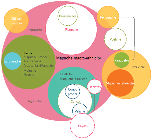
The Mapuche ( (Mapuche & Spanish: )) are a group of indigenous inhabitants of south-central Chile and southwestern Argentina, including parts of Patagonia. The collective term refers to a wide-ranging ethnicity composed of various groups who shared a common social, religious, and economic structure, as well as a common linguistic heritage as Mapudungun speakers. Their habitat once extended from Aconcagua Valley to Chiloé Archipelago and later spread eastward to Puelmapu, a land comprising part of the Argentine pampa and Patagonia. Today the collective group makes up over 80% of the indigenous peoples in Chile, and about 9% of the total Chilean population. The Mapuche are particularly concentrated in the Araucanía region. Many have migrated from rural areas to the cities of Santiago and Buenos Aires for economic opportunities. The Mapuche traditional economy is based on agriculture; their traditional social organization consists of extended families, under the direction of a ... [...More Info...] [...Related Items...] OR: [Wikipedia] [Google] [Baidu] |
Puyuhuapi
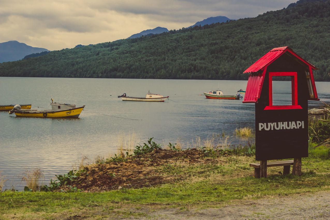
Puyuhuapi (Puyuguapi) is a village in southern Chile in the Aysén Region. It is located on Route 7, the Carretera Austral, where the Rio Pascal enters the head of the Puyuhuapi fjord, a small fjord off the Ventisquero Sound. Its harbor on the fjord is called Puerto Puyuhuapi. Puyuhuapi is administratively in the Chilean commune of Cisnes. In the 2002 census it had a population of 535, but by 2007 it had grown to 826. Just southwest of the village are the Puyuhuapi hot springs. The government invited German settlement in the village, which was founded by Sudeten German settlers from Hranice (former German name Rossbach) in present-day Czech Republic and Mapuches from Chiloé Archipelago. German settlers gave temporary work to the Mapuches in the area, and then they settled with their families, which gave rise to a mestizo population. It is served by Puyuhuapi Airport. Among the local handicrafts are hand-made jerseys. In popular culture Puyuhuapi was featured in the 2014 ... [...More Info...] [...Related Items...] OR: [Wikipedia] [Google] [Baidu] |
Chile
Chile, officially the Republic of Chile, is a country in the western part of South America. It is the southernmost country in the world, and the closest to Antarctica, occupying a long and narrow strip of land between the Andes to the east and the Pacific Ocean to the west. Chile covers an area of , with a population of 17.5 million as of 2017. It shares land borders with Peru to the north, Bolivia to the north-east, Argentina to the east, and the Drake Passage in the far south. Chile also controls the Pacific islands of Juan Fernández, Isla Salas y Gómez, Desventuradas, and Easter Island in Oceania. It also claims about of Antarctica under the Chilean Antarctic Territory. The country's capital and largest city is Santiago, and its national language is Spanish. Spain conquered and colonized the region in the mid-16th century, replacing Inca rule, but failing to conquer the independent Mapuche who inhabited what is now south-central Chile. In 1818, after declaring in ... [...More Info...] [...Related Items...] OR: [Wikipedia] [Google] [Baidu] |
Sudeten German
German Bohemians (german: Deutschböhmen und Deutschmährer, i.e. German Bohemians and German Moravians), later known as Sudeten Germans, were ethnic Germans living in the Czech lands of the Bohemian Crown, which later became an integral part of Czechoslovakia. Before 1945, over three million German Bohemians constituted about 23% of the population of the whole country and about 29.5% of the population of Bohemia and Moravia. Ethnic Germans migrated into the Kingdom of Bohemia, an electoral territory of the Holy Roman Empire, from the 11th century, mostly in the border regions of what was later called the "Sudetenland", which was named after the Sudeten Mountains. The process of German expansion was known as ''Ostsiedlung'' ("Settling of the East"). The name "Sudeten Germans" was adopted during rising nationalism after the fall of Austria-Hungary after the First World War. After the Munich Agreement, the so-called Sudetenland became part of Germany. After the Second World Wa ... [...More Info...] [...Related Items...] OR: [Wikipedia] [Google] [Baidu] |
Městys
Městys (or, unofficially or obsolete, městečko (literally "small town")), translated as "market town", is a status conferred on certain municipalities in the Czech Republic, lying in terms of size and importance higher than that of simple ''obec'' (municipality), but lower than that of ''město'' (city, town). Historically a ''městys'' was a locality which had the right to stage livestock markets (and some other "extraordinary" and annual markets), and it is therefore translated as "market town". The term went out of official use in Czechoslovakia in 1954, but was reintroduced in the Czech Republic in 2006. As of September 2020, there are 228 municipalities on which the status of ''městys'' has been re-admitted. In all cases, these are municipalities that have requested the return of their former title. This title has not been newly awarded to any municipality that would not have it in the past, the law does not even set any specific criteria for it, only procedural competenc ... [...More Info...] [...Related Items...] OR: [Wikipedia] [Google] [Baidu] |
County Of Neipperg
County of Neipperg was a county of southeastern Baden-Württemberg, Germany. Barony of Neipperg-Schwaigern was created in 1520 as a baronial partition of the Barony of Neipperg, It was renamed from Neipperg-Schwaigern in 1726, and raised to a county in 1766. Neipperg was mediatised to the Kingdom of Württemberg The Kingdom of Württemberg (german: Königreich Württemberg ) was a German state that existed from 1805 to 1918, located within the area that is now Baden-Württemberg. The kingdom was a continuation of the Duchy of Württemberg, which exist ... in 1806. Counts of Neipperg (1726–1806) * Wilhelm Reinhard (1726-1774) * Leopold (1774-1792) * Joseph (1792-1806) References 1726 establishments in the Holy Roman Empire Counties of the Holy Roman Empire {{Germany-hist-stub ... [...More Info...] [...Related Items...] OR: [Wikipedia] [Google] [Baidu] |
House Of Zedtwitz
The House of Zedtwitz is the name of an old and distinguished German and Czech noble house which originated from Franconia, Germany. History The family first appeared in a written document in 1235 and later in 1288 where progenitor Berthold von Zedwitz is mentioned. Between c. 1400 and c. 1945 it ruled the region around the town of Aš. The family had several lines, one of which was Baronial and the other branch received the title of Imperial Count in 1766, as well as Count in Bavaria on 25. August 1790 by Charles Theodore, Elector of Bavaria. Properties Image:Doubrava - bývalý zámeček Zedwitzů 08-06-14.JPG, Zedtwitz castle in Doubrava. Image:Libá chateau 2008-06-28.JPG, Zedtwitz castle Libá, in Libá. Notable members * Curt Franz Wenzel Christoph Erdmann Zedtwitz, ''Graf von'' Moraván und Duppau (1822–1909) * Peter Emanuel ''Freiherr von'' Zedtwitz(-Liebenstein) (1715–1786) (de) See also * The von Zedtwitz Life Master Pairs, national bridge champio ... [...More Info...] [...Related Items...] OR: [Wikipedia] [Google] [Baidu] |
Fichtel Mountains
The Fichtel MountainsRandlesome, C. et al. (2011). ''Business Cultures in Europe'', 2nd ed., Routledge, Abingdon and New York, p. 52. . (german: Fichtelgebirge, cs, Smrčiny), form a small horseshoe-shaped mountain range in northeastern Bavaria, Germany. They extend from the valley of the Red Main River to the Czech border, a few foothills spilling over into the Czech Republic. They continue in a northeasterly direction as the Elster Mountains, and in a southeasterly direction as the Upper Palatine Forest. The Fichtel Mountains contain an important nature park, the Fichtel Mountain Nature Park, with an area of . Etymology The first person to write about the Fichtel Mountains, Matthias of Kemnath (actually Matthias Widmann, born 23 February 1429 in Kemnath) reported in 1476: ''Ein bergk, hoch, weitt, wolbekant ligt in Beiern, gnant der Fichtelberg'' ("A mountain, high, wide and well-known, lies in Bavaria, known as the Fichtelberg"). In descriptions of the border in 1499 and 15 ... [...More Info...] [...Related Items...] OR: [Wikipedia] [Google] [Baidu] |


