|
Holmbank
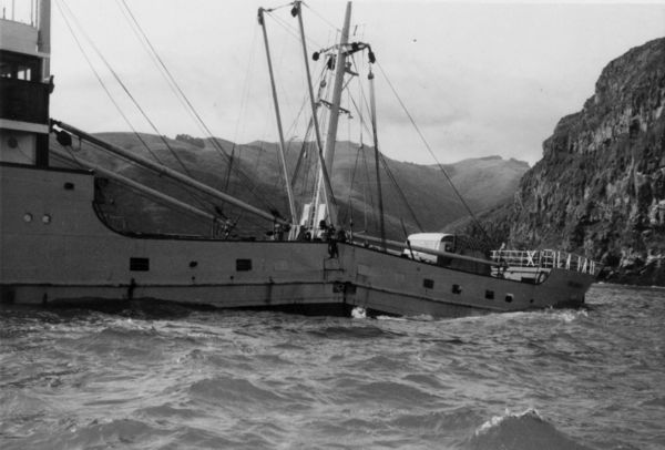
''Holmbank'' was a Norwegian ship built in 1948 and launched as ''Anne''. It sank in New Zealand in 1963. Construction ''Holmbank'' was of steel construction, built in the yard of Bergens Mek Verk, Bergen, Norway. Launched in 1948, ''Holmbank'' had a gross tonnage of 515 tons. Length 53m, beam 8.6m, draft 3.7m. Powered by diesel engines, ''Holmbank'' was propelled by a single screw. When sailing in New Zealand, it was one of the first vessels on the New Zealand coast with a controllable pitch propeller. Ownership and name changes ''Holmbank'' was named ''Anne'' when launched in 1948, being renamed ''Sunny Girl'' the following year. Bought by a New Zealand company, the vessel was renamed ''Turihau'' in 1952, before finally being renamed ''Holmbank'' in 1962 when bought by Holm Shipping Company. Voyages ''Holmbank'' was employed in coastal trade throughout New Zealand from 1952 until 1963. Between 1952 and 1961, while named ''Turihau'', the vessel was involved in four cas ... [...More Info...] [...Related Items...] OR: [Wikipedia] [Google] [Baidu] |
Holmbank Wrecked On Whale Rock
''Holmbank'' was a Norwegian ship built in 1948 and launched as ''Anne''. It sank in New Zealand in 1963. Construction ''Holmbank'' was of steel construction, built in the yard of Bergens Mek Verk, Bergen, Norway. Launched in 1948, ''Holmbank'' had a gross tonnage of 515 tons. Length 53m, beam 8.6m, draft 3.7m. Powered by diesel engines, ''Holmbank'' was propelled by a single screw. When sailing in New Zealand, it was one of the first vessels on the New Zealand coast with a controllable pitch propeller. Ownership and name changes ''Holmbank'' was named ''Anne'' when launched in 1948, being renamed ''Sunny Girl'' the following year. Bought by a New Zealand company, the vessel was renamed ''Turihau'' in 1952, before finally being renamed ''Holmbank'' in 1962 when bought by Holm Shipping Company. Voyages ''Holmbank'' was employed in coastal trade throughout New Zealand from 1952 until 1963. Between 1952 and 1961, while named ''Turihau'', the vessel was involved in four cas ... [...More Info...] [...Related Items...] OR: [Wikipedia] [Google] [Baidu] |
Holm & Co
Holm & Co were ship owners, ship brokers and stevedores based in Wellington, New Zealand. They were agents for Australian and other foreign airways and shipping lines. The business was founded by Swedish-born Captain Pehr Ferdinand Holm (1844—1917) when he bought the barque Genevie M Tucker in 1889. He had settled in Wellington in 1868. His last sailing ship was the barquentine Titania wrecked off Nouméa in 1914 when the lighthouse was under a wartime blackout. Two sons became marine engineers and two became master mariners. Sydney Holm ran the business before his father died and thereafter. A company was incorporated to take ownership of the business in 1918 with offices in the Huddart Parker Line building in Wellington's Post Office Square.NZ Ship & Marine Society accessed 18 September 2021 The [...More Info...] [...Related Items...] OR: [Wikipedia] [Google] [Baidu] |
Bergen
Bergen (), historically Bjørgvin, is a city and municipality in Vestland county on the west coast of Norway. , its population is roughly 285,900. Bergen is the second-largest city in Norway. The municipality covers and is on the peninsula of Bergenshalvøyen. The city centre and northern neighbourhoods are on Byfjorden, 'the city fjord', and the city is surrounded by mountains; Bergen is known as the "city of seven mountains". Many of the extra-municipal suburbs are on islands. Bergen is the administrative centre of Vestland county. The city consists of eight boroughs: Arna, Bergenhus, Fana, Fyllingsdalen, Laksevåg, Ytrebygda, Årstad, and Åsane. Trading in Bergen may have started as early as the 1020s. According to tradition, the city was founded in 1070 by King Olav Kyrre and was named Bjørgvin, 'the green meadow among the mountains'. It served as Norway's capital in the 13th century, and from the end of the 13th century became a bureau city of the Hanseatic Leag ... [...More Info...] [...Related Items...] OR: [Wikipedia] [Google] [Baidu] |
Mercury Islands
The Mercury Islands are a group of seven islands off the northeast coast of New Zealand's North Island. They are located off the coast of the Coromandel Peninsula, and northeast of the town of Whitianga. History The Ngāti Karaua (a hapu of the Ngāti Whanaunga) and the Ngāti Hei inhabited the islands since the 14th century. A settler claimed to have bought Great Mercury Island in 1839.https://www.govt.nz/assets/Documents/OTS/Ngati-Hei/Ngati-Hei-Deed-of-Settlement-17-Aug-2017.pdf Great Mercury (Ahuahu), Kawhitu or Stanley Island and Double Island (Moturehu) where purchased and taken as crown land in 1858–65. These included Whakakapua (73 acres) and Kowhaka (21 acres) being purchased in January 1865. Despite inhabiting Ahuahu, the Ngati Hei were not consulted about this purchase. A 2017 settlement recognized the Ngāti Hei as having a legitimate claim to Great Mercury Island. Description The main chain of the Mercury Islands consists of the large Great Mercury Island (a ... [...More Info...] [...Related Items...] OR: [Wikipedia] [Google] [Baidu] |
Cape Jackson, New Zealand
Cape Jackson is a peninsula in Marlborough, in the South Island of New Zealand. It lies between Queen Charlotte Sound and Cook Strait. Cape Jackson's history involves gold mining, sheep farming, and more recently carbon farming (growing trees for carbon sequestration purposes). Cape Jackson is privately owned. The land is reserved as a private wilderness park known aQueen Charlotte Wilderness Park and is available to the public via arrangement with the owners. The cliffs on Cape Jackson are known as , , named for their resemblance to nets being hung out to dry. According to legend Kupe left a fishing net here. Major efforts are underway to regenerate the native bush which once covered the of the peninsula. Naming ''Cape Jackson'' was named by James Cook on the 29th of March 1770, after Sir George Jackson, one of the Admiralty secretaries and a friend & patron of Cook. ''Te Taonui-a-Kupe'' is the Māori Māori or Maori can refer to: Relating to the Māori people * Mā ... [...More Info...] [...Related Items...] OR: [Wikipedia] [Google] [Baidu] |
Timaru
Timaru (; mi, Te Tihi-o-Maru) is a port city in the southern Canterbury Region of New Zealand, located southwest of Christchurch and about northeast of Dunedin on the eastern Pacific coast of the South Island. The Timaru urban area is home to people, and is the largest urban area in South Canterbury, and the second largest in the Canterbury Region overall, after Christchurch. The town is the seat of the Timaru District, which includes the surrounding rural area and the towns of Geraldine, Pleasant Point and Temuka, which combined have a total population of . Caroline Bay beach is a popular recreational area located close to Timaru's main centre, just to the north of the substantial port facilities. Beyond Caroline Bay, the industrial suburb of Washdyke is at a major junction with State Highway 8, the main route into the Mackenzie Country. This provides a road link to Pleasant Point, Fairlie, Twizel, Lake Tekapo, Aoraki / Mount Cook and Queenstown. Timaru has been built ... [...More Info...] [...Related Items...] OR: [Wikipedia] [Google] [Baidu] |
Wellington
Wellington ( mi, Te Whanganui-a-Tara or ) is the capital city of New Zealand. It is located at the south-western tip of the North Island, between Cook Strait and the Remutaka Range. Wellington is the second-largest city in New Zealand by metro area, and is the administrative centre of the Wellington Region. It is the world's southernmost capital of a sovereign state. Wellington features a temperate maritime climate, and is the world's windiest city by average wind speed. Legends recount that Kupe discovered and explored the region in about the 10th century, with initial settlement by Māori iwi such as Rangitāne and Muaūpoko. The disruptions of the Musket Wars led to them being overwhelmed by northern iwi such as Te Āti Awa by the early 19th century. Wellington's current form was originally designed by Captain William Mein Smith, the first Surveyor General for Edward Wakefield's New Zealand Company, in 1840. The Wellington urban area, which only includes urbanised ar ... [...More Info...] [...Related Items...] OR: [Wikipedia] [Google] [Baidu] |
Akaroa
Akaroa is a small town on Banks Peninsula in the Canterbury Region of the South Island of New Zealand, situated within a harbour of the same name. The name Akaroa is Kāi Tahu Māori for "Long Harbour", which would be spelled in standard Māori. The area was also named ''Port Louis-Philippe'' by French settlers after the reigning French king Louis Philippe I. The town is by road from Christchurch and is the terminus of State Highway 75. It is set on a sheltered harbour and is overlooked and surrounded by the remnants of a miocene volcano. Akaroa is entirely dependent upon rainfall on the hills. Akaroa is a popular resort town. Many Hector's dolphins may be found within the harbour, and 'swim with the dolphins' boat tours are a major tourist attraction. Ōnuku marae, a (tribal meeting ground) of Ngāi Tahu and its Ōnuku Rūnanga branch, is located in Akaroa. It includes the Karaweko (meeting house). History In 1830, the Māori settlement at Takapūneke, just east ... [...More Info...] [...Related Items...] OR: [Wikipedia] [Google] [Baidu] |
Peraki
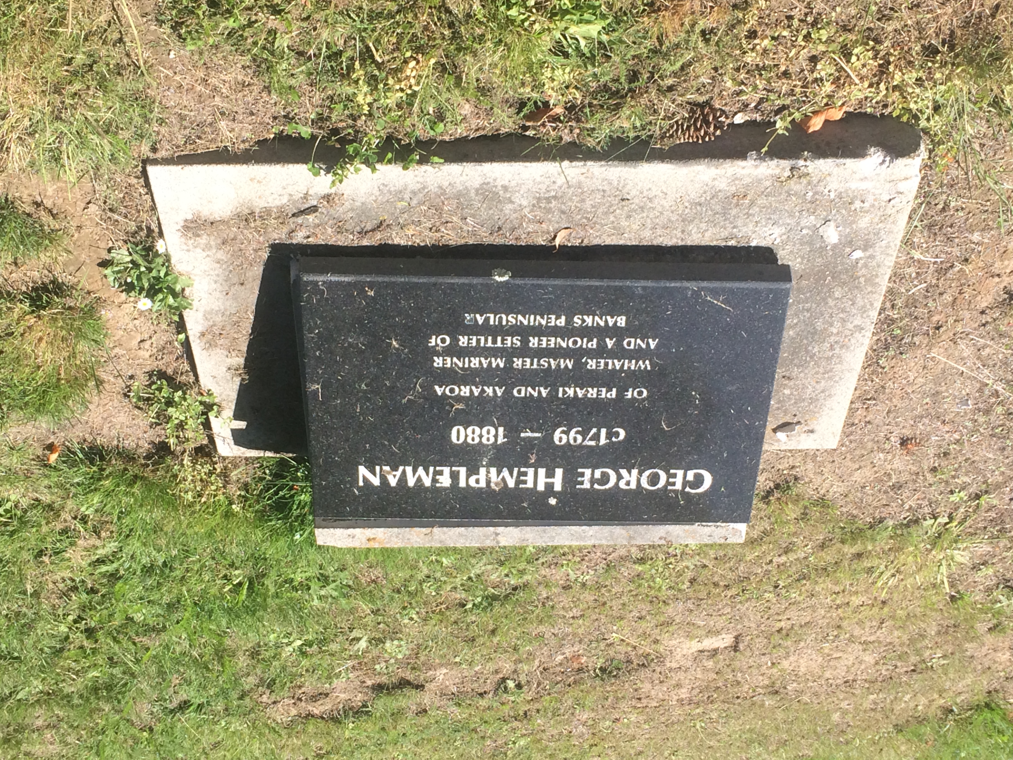
Peraki, a Māori language place name with an initial spelling of Pireka, is a bay on the south side of Banks Peninsula, New Zealand. It is the site of the first permanent European settlement in Canterbury. George Hempelman, a Prussian whaler, established a whaling station in the bay in 1835, and from 1837 lived there permanently. Peraki has a small cemetery, one of the earliest European cemeteries in New Zealand. The Wairewa and Akaroa Counties paid for a memorial to Hempelman that was placed on Peraki Beach in March 1939. The memorial is made up of a whale try pot with the following inscription: Erected to commemorate the centenary of the first white settler in Canterbury, New Zealand, Captain George Hempelman, who established a whaling station at Peraki in 1835. Hempelman flew the German flag in front of his house, and in 1840 he was ordered by Captain Owen Stanley Captain Owen Stanley FRS RN (13 June 1811 – 13 March 1850) was a British Royal Navy officer and surve ... [...More Info...] [...Related Items...] OR: [Wikipedia] [Google] [Baidu] |
Shipwrecks Of Banks Peninsula
A shipwreck is the wreckage of a ship that is located either beached on land or sunken to the bottom of a body of water. Shipwrecking may be intentional or unintentional. Angela Croome reported in January 1999 that there were approximately three million shipwrecks worldwide (an estimate rapidly endorsed by UNESCO and other organizations). When a ship's crew has died or abandoned the ship, and the ship has remained adrift but unsunk, they are instead referred to as ghost ships. Types Historic wrecks are attractive to maritime archaeologists because they preserve historical information: for example, studying the wreck of revealed information about seafaring, warfare, and life in the 16th century. Military wrecks, caused by a skirmish at sea, are studied to find details about the historic event; they reveal much about the battle that occurred. Discoveries of treasure ships, often from the period of European colonisation, which sank in remote locations leaving few l ... [...More Info...] [...Related Items...] OR: [Wikipedia] [Google] [Baidu] |


